Berwick, Pennsylvania
| Berwick, Pennsylvania | |
|---|---|
| Borough | |
|
Dickson Block in 1912 | |
| Motto: "Proud of Our Heritage" | |
 Location of Berwick in Columbia County | |
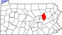 Location of Columbia County in Pennsylvania | |
 Berwick Location of Berwick in Pennsylvania | |
| Coordinates: 41°03′17″N 76°14′01″W / 41.05472°N 76.23361°WCoordinates: 41°03′17″N 76°14′01″W / 41.05472°N 76.23361°W | |
| Country | United States |
| State | Pennsylvania |
| County | Columbia, Luzerne |
| Settled | 1769 |
| Incorporated | 1818 |
| Government | |
| • Type | Borough Council |
| • Mayor | Tim Burke |
| • Council President | Alvin Hill |
| • Borough Manager | Robert Hivish, Jr. |
| • Fire Chief | William Coolbaugh |
| • Police Chief | Kenneth Strish |
| Area | |
| • Total | 3.25 sq mi (8.43 km2) |
| • Land | 3.08 sq mi (7.97 km2) |
| • Water | 0.18 sq mi (0.46 km2) |
| Elevation[1] | 558 ft (170 m) |
| Population (2010) | |
| • Total | 10,477 |
| • Density | 3,406/sq mi (1,314.9/km2) |
| Time zone | Eastern (EST) (UTC-5) |
| • Summer (DST) | EDT (UTC-4) |
| ZIP code | 18603 |
| Area code(s) | 570 Exchanges: 752,759 |
| Website |
www |

Berwick is a borough in Columbia County, Pennsylvania, United States, 28 miles (45 km) southwest of Wilkes Barre. As of the 2010 census, Berwick had a population of 10,477.[2] It is one of the two principal communities of the Bloomsburg-Berwick, PA Micropolitan Statistical Area, a micropolitan area that covers Columbia and Montour counties,[3] and had a combined population of 85,562 at the 2010 census.[4]
History
Berwick was founded by Evan Owen, a Welsh Quaker and surveyor. He was the son of Hugh Owen from Trefeglwys, Montgomeryshire, Wales. Berwick was named after Berwick-upon-Tweed, England. Situated on the north bank of the Susquehanna River, the borough was first settled in 1769, founded in 1786, and incorporated in 1818.
Light and heavy manufacturing industries, such as American Car and Foundry Company and Wise Potato Chips, have flourished in Berwick, which consolidated with the borough of West Berwick, where 5,512 people lived in 1910. The population of Berwick in 1910 was 5,357; in 1920, after consolidation, the population was 12,181; and in 1950 the population peaked at 14,010. The population was 10,477 at the 2010 census. Berwick is famous for its high school football team, the Bulldogs, who are six time state champions and three time national champions. Berwick is also the home of the 2008 PIAA AAA baseball state champions. It is the school's first ever baseball state championship.

Since 1947, the Berwick Christmas Boulevard, created by the Jaycees, displays over a mile long Christmas show of lights and displays down Market Street. The Berwick Christmas Boulevard is seen by thousands of visitors every year, and it has been a regional favorite for over 60 years.[5] Santa Claus is present every year to serve Berwick's famous Wise Potato Chips to everyone who drives past him.

The Berwick Armory and Jackson Mansion and Carriage House are listed on the National Register of Historic Places.[6] [7]
Geography

Berwick is located in eastern Columbia County, bordered to the north by Briar Creek Township, to the west by Briar Creek borough, to the south across the Susquehanna River by Mifflin Township, and to the east by Salem Township in Luzerne County. The borough of Nescopeck in Luzerne County is to the southeast, across the Susquehanna. According to the United States Census Bureau, Berwick has a total area of 3.25 square miles (8.43 km2), of which 3.08 square miles (7.97 km2) is land and 0.18 square miles (0.46 km2), or 5.45%, is water.[2]
U.S. Route 11 runs through the center of Berwick as Front Street (one-way northeast) and Second Street (one-way southwest). US 11 leads northeast 26 miles (42 km) to Kingston, across the Susquehanna from Wilkes-Barre, and southwest 12 miles (19 km) to Bloomsburg, the Columbia County seat. Pennsylvania Route 93 shares Front and Second Streets with US 11 in the center of Berwick, but turns south to cross the Susquehanna via the Market Street Bridge to Nescopeck.[8] In the other direction, PA 93 splits west from US 11 as Orange Street and leads 10 miles (16 km) to Orangeville.
Interstate 80 passes south of Berwick, with the closest exits being at US 11, 6 miles (10 km) southwest of town, and at PA 93, 9 miles (14 km) southeast of town.
The eastern terminus of the Susquehanna, Bloomsburg, and Berwick Railroad used to be in Berwick.[9]
Demographics
| Historical population | |||
|---|---|---|---|
| Census | Pop. | %± | |
| 1870 | 923 | — | |
| 1880 | 2,095 | 127.0% | |
| 1890 | 2,701 | 28.9% | |
| 1900 | 3,916 | 45.0% | |
| 1910 | 5,357 | 36.8% | |
| 1920 | 12,181 | 127.4% | |
| 1930 | 12,660 | 3.9% | |
| 1940 | 13,181 | 4.1% | |
| 1950 | 14,010 | 6.3% | |
| 1960 | 13,353 | −4.7% | |
| 1970 | 12,274 | −8.1% | |
| 1980 | 11,850 | −3.5% | |
| 1990 | 10,976 | −7.4% | |
| 2000 | 10,774 | −1.8% | |
| 2010 | 10,477 | −2.8% | |
| Est. 2015 | 10,223 | [10] | −2.4% |
| Sources:[11][12][13][14] | |||
As of the census[13] of 2000, there were 10,774 people, 4,595 households, and 2,802 families residing in the borough. The population density was 3,477.0 people per square mile (1,341.9/km²). There were 4,992 housing units at an average density of 1,611.0 per square mile (621.7/km²). The racial makeup of the borough was 97.10% White, 0.88% African American, 0.28% Native American, 0.43% Asian, 0.05% Pacific Islander, 0.61% from other races, and 0.65% from two or more races. Hispanic or Latino of any race were 1.62% of the population.
The Berwick area had a large influx of immigrants approximately between 1890–1920, which had a great impact on the current population that continues to this day. These immigrants included Slovaks, Ukrainians, Ruthenians, Lithuanians, and Poles. These immigrants were primarily Eastern Catholic and Roman Catholic.
There were 4,595 households, out of which 26.4% had children under the age of 18 living with them, 43.8% were married couples living together, 12.3% had a female householder with no husband present, and 39.0% were non-families. 33.6% of all households were made up of individuals, and 17.0% had someone living alone who was 65 years of age or older. The average household size was 2.28 and the average family size was 2.90.
In the borough the population was spread out, with 23.1% under the age of 18, 7.7% from 18 to 24, 27.1% from 25 to 44, 21.5% from 45 to 64, and 20.7% who were 65 years of age or older. The median age was 40 years. For every 100 females there were 87.8 males. For every 100 females age 18 and over, there were 84.6 males.
The median income for a household in the borough was $27,442, and the median income for a family was $32,357. Males had a median income of $26,467 versus $21,061 for females. The per capita income for the borough was $14,538. About 9.6% of families and 14.9% of the population were below the poverty line, including 20.8% of those under age 18 and 11.1% of those age 65 or over.
Economy

Berwick was one of the places where the Stuart tank was produced in World War II. American Car & Foundry, a producer of rolling stock for railroads, also operated a plant in Berwick. The borough is home to Berwick Offray, a gift ribbon manufacturing division of CSS Industries, and Wise Foods, a snack food company founded by Berwick native Earl Wise in the first half of the twentieth century, famous for its potato chips.
Education
Berwick is home to the Berwick Area School District. There are six public schools located within the district: Berwick Area High School, Berwick Area Middle School, Fourteenth Street Elementary School, Nescopeck Elementary School, Orange Street Elementary School, and Salem Elementary School.[15] According to the Pennsylvania Department of Education, as of the 2009-10 school year, 94% of all students in the district attend class regularly and 88% of all students graduate on time.[16]
Berwick is also served by Columbia-Montour Area Vocational-Technical School, Central Susquehanna Intermediate Unit 16, as well as three private schools: Holy Family School, a Catholic-based school for grades K-5, Heritage Christian Academy, a Baptist-based school for grades K-12, and New Story, a school for children with serious and complex educational and behavioral challenges.[17][18]

Berwick is home to a dedicated campus of Luzerne County Community College, located in the Eagles Building.[19] Nearby colleges and universities include Bloomsburg University (12.4 mi), Penn State Hazleton (14.2 mi), the main campus of Luzerne County Community College in Nanticoke (21.9 mi), King's College (28.2 mi), and Wilkes University (28.2 mi).

The McBride Memorial Library, built at a cost of $2.35 million and opened to the public in January 2008, serves the residents of Berwick and its surrounding areas.[20] Nearby libraries include the Columbia County Traveling Library, the Bloomsburg Public Library, the Orangeville Public Library, and libraries at those colleges and universities listed above.
Notable people
- Nick Adams, actor (interred)
- Thomas Bowman, Methodist Episcopal bishop
- Russ Canzler, baseball player - third base
- George Curry, football coach
- Matt Karchner, baseball pitcher
- Jake Kelchner, football quarterback
- Douglas Major, composer of sacred music and concert organist
- Warren P. Noble, congressman
- Bo Orlando, football player
- Billy Petrolle, boxer
- Tony Piet, baseball player
- Ron Powlus, football quarterback
- Benjamin F. Rittenhouse, Civil War hero
- Mike Souchak, golfer
- Jimmy Spencer, racecar driver and commentator
- Ted Stuban, politician
- Jayson Terdiman, Olympic luger
- Joe Torsella, museum director
- William H. Woodin, FDR's first Treasury Secretary
Climate
The Köppen Climate Classification subtype for this climate is "Dfb" (Warm Summer Continental Climate).[21]
| Climate data for Berwick, Pennsylvania | |||||||||||||
|---|---|---|---|---|---|---|---|---|---|---|---|---|---|
| Month | Jan | Feb | Mar | Apr | May | Jun | Jul | Aug | Sep | Oct | Nov | Dec | Year |
| Average high °C (°F) | 2 (36) |
4 (39) |
9 (48) |
17 (62) |
23 (73) |
28 (82) |
30 (86) |
29 (84) |
24 (76) |
19 (66) |
11 (51) |
4 (39) |
17 (62) |
| Average low °C (°F) | −7 (19) |
−7 (20) |
−2 (28) |
3 (37) |
9 (48) |
14 (57) |
16 (61) |
16 (60) |
12 (53) |
5 (41) |
1 (33) |
−5 (23) |
4 (40) |
| Average precipitation mm (inches) | 58 (2.3) |
58 (2.3) |
69 (2.7) |
86 (3.4) |
100 (4) |
91 (3.6) |
104 (4.1) |
100 (4) |
91 (3.6) |
71 (2.8) |
81 (3.2) |
74 (2.9) |
990 (39) |
| Source: Weatherbase [22] | |||||||||||||
Photo gallery
-

The fire hall of the East Berwick Fire Co.
-

Defender volunteer fire company. The older engine for show and parades
-

Berwick Christian Church
-

Berwick Assembly of God Church
-

Bower Memorial United Methodist Church
-

Berwick has a special relationship with Berwick-Upon-Tweed in England.
-

Berwick Theater, still showing films in 2015
-

1st United Methodist Church
-

Salvation Army building
-
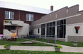
The Berwick YMCA, in a former school building
-

Water storage tank for Wise Snacks
-

Dalo's, a long-standing bakery
-

May's Drive In, long time landmark
-

Berwick Red Cross building
-
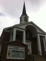
St. Paul United Methodist Church
-

Seventh Day Adventist Church
-

St. Joseph Catholic Church
-

Grace Lutheran Church
-

Calvary United Methodist Church
-

1st United Church of Christ
-

Knights of Columbus
-

The Elks club building
-

VFW post
-

Army tank behind VFW post
-

"Double house" (duplex), one of many built in first half of 20th century
-

Edith Orvis, who came to help meet the social and spiritual needs of immigrants
-

Founders of Berwick
-

Crispin Field, home of the Bulldogs
-

Four and a half street, a unique street name, running from Berwick into Salem Township
References
- ↑ http://geonames.usgs.gov/pls/gnispublic/f?p=gnispq:3:::NO::P3_FID:1169321
- 1 2 "Geographic Identifiers: 2010 Census Summary File 1 (G001): Berwick borough, Pennsylvania". U.S. Census Bureau, American Factfinder. Retrieved May 19, 2015.
- ↑ MICROPOLITAN STATISTICAL AREAS AND COMPONENTS Archived June 29, 2007, at the Wayback Machine., Office of Management and Budget, May 11, 2007. Accessed 2008-07-27.
- ↑ "Profile of General Population and Housing Characteristics: 2010 Census Summary File 1 (DP-1): Bloomsburg-Berwick, PA Micro Area". U.S. Census Bureau, American Factfinder. Retrieved May 19, 2015.
- ↑ http://www.berwickborough.org/index.php?pageid=14
- ↑ National Park Service (2010-07-09). "National Register Information System". National Register of Historic Places. National Park Service.
- ↑ Ninnau March 2004
- ↑ maps.google.com
- ↑ books.google.com ("Susquehanna, Bloomsburg, and Berwick Railroad")
- ↑ "Annual Estimates of the Resident Population for Incorporated Places: April 1, 2010 to July 1, 2015". Retrieved July 2, 2016.
- ↑ "Number of Inhabitants: Pennsylvania" (PDF). 18th Census of the United States. U.S. Census Bureau. Retrieved 22 November 2013.
- ↑ "Pennsylvania: Population and Housing Unit Counts" (PDF). U.S. Census Bureau. Retrieved 22 November 2013.
- 1 2 "American FactFinder". United States Census Bureau. Archived from the original on 2013-09-11. Retrieved 2008-01-31.
- ↑ "Annual Estimates of the Resident Population". U.S. Census Bureau. Retrieved 22 November 2013.
- ↑ http://nces.ed.gov/ccd/schoolsearch/school_list.asp?Search=1&DistrictID=4203480
- ↑ http://paayp.emetric.net/Content/reportcards/RC10D116191103.PDF[]
- ↑ http://holyfamilyschoolberwick.org/about.php[]
- ↑ "Archived copy". Archived from the original on 2011-09-01. Retrieved 2011-07-16.
- ↑ http://www.luzerne.edu/about/oc/berwick.jsp?offcampus=BERW
- ↑ "Archived copy". Archived from the original on 2011-07-27. Retrieved 2011-07-16.
- ↑ Climate Summary for Berwick, Pennsylvania
- ↑ "Weatherbase.com". Weatherbase. 2013. Retrieved on August 9, 2013.
External links
Municipalities and communities of Columbia County, Pennsylvania, United States | ||
|---|---|---|
| Town | | |
| Boroughs | ||
| Townships | ||
| CDPs | ||
| Unincorporated communities | ||
| Ghost Towns | ||
| Footnotes | ‡This populated place also has portions in an adjacent county or counties | |