South Centre Township, Columbia County, Pennsylvania
| South Centre Township, Pennsylvania | |
|---|---|
| Township | |
|
Field in South Centre Township | |
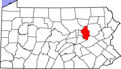
 Map of Columbia County, Pennsylvania highlighting South Centre Township | |
 Map of Columbia County, Pennsylvania | |
| Country | United States |
| State | Pennsylvania |
| County | Columbia |
| Settled | 1771 |
| Incorporated | 1923 |
| Area | |
| • Total | 5.9 sq mi (15.4 km2) |
| • Land | 5.4 sq mi (14.1 km2) |
| • Water | 0.5 sq mi (1.4 km2) |
| Population (2010) | |
| • Total | 1,937 |
| • Density | 357/sq mi (137.7/km2) |
| Time zone | Eastern (EST) (UTC-5) |
| • Summer (DST) | EDT (UTC-4) |
| Area code(s) | 570 |
| Website |
www |

South Centre Township is a township in Columbia County, Pennsylvania, United States. The population was 1,937 at the 2010 census.[1]
Geography
South Centre Township is located east of the geographic center of Columbia County, along the north side of the Susquehanna River. It is bordered to the west by Scott Township, to the north by North Centre Township, to the east by the borough of Briar Creek, and to the south, across the Susquehanna, by Mifflin Township and Main Township. The unincorporated community of Lime Ridge is in the southern part of the township, along the Susquehanna, and a portion of Almedia is in the southwest corner.
Interstate 80 passes through the township, crossing the Susquehanna into Mifflin Township. Access to I-80 is at Exit 241 (U.S. Route 11), next to Lime Ridge. US 11 runs parallel to the Susquehanna, leading west towards Bloomsburg, the county seat, and east through Briar Creek to Berwick.
According to the United States Census Bureau, South Centre Township has a total area of 5.9 square miles (15.4 km2), of which 5.4 square miles (14.1 km2) is land and 0.54 square miles (1.4 km2), or 8.82%, is water.[1]
Demographics
As of the census[2] of 2000, there were 1,972 people, 822 households, and 571 families residing in the township. The population density was 370.7 people per square mile (143.1/km²). There were 865 housing units at an average density of 162.6/sq mi (62.8/km²). The racial makeup of the township was 98.99% White, 0.15% African American, 0.05% Native American, 0.25% Asian, 0.05% Pacific Islander, 0.05% from other races, and 0.46% from two or more races. Hispanic or Latino of any race were 1.06% of the population.
There were 822 households, out of which 29.1% had children under the age of 18 living with them, 55.8% were married couples living together, 10.0% had a female householder with no husband present, and 30.5% were non-families. 25.4% of all households were made up of individuals, and 10.0% had someone living alone who was 65 years of age or older. The average household size was 2.39 and the average family size was 2.84.
In the township the population was spread out, with 22.0% under the age of 18, 7.0% from 18 to 24, 29.2% from 25 to 44, 26.5% from 45 to 64, and 15.3% who were 65 years of age or older. The median age was 40 years. For every 100 females there were 95.2 males. For every 100 females age 18 and over, there were 90.3 males.
The median income for a household in the township was $34,764, and the median income for a family was $40,395. Males had a median income of $27,875 versus $21,507 for females. The per capita income for the township was $16,600. About 6.2% of families and 9.6% of the population were below the poverty line, including 12.2% of those under age 18 and 8.2% of those age 65 or over.
Education
The area's local school district is the Central Columbia School District. It serves about 2,100 students and features three academic buildings and one administration building. Students are divided into the Elementary School (grades K through 4), Middle School (grades 5 through 8) and the High School (grades 9 through 12).
According to the 2003 data collected by Standard & Poor's, 18.4% of students are economically disadvantaged, 13.1% receive special education services and 71.1% of students pass the state-mandated testing. The district spends about $6,999 per student.[3]
In 2007, the Pittsburgh Business Times ranked the district 146th out of 499 Pennsylvania school districts based on three years of Pennsylvania System of Student Assessment test scores.[4]
The Middle School is under construction, as of 2006. Several small additions are being added to accommodate the increasing class size, and a major renovation on the existing portion will bring it up to code. It's expected to be near completion by the beginning of the 2007-2008 school year.
References
- 1 2 "Geographic Identifiers: 2010 Census Summary File 1 (G001): South Centre township, Columbia County, Pennsylvania". U.S. Census Bureau, American Factfinder. Retrieved May 27, 2015.
- ↑ "American FactFinder". United States Census Bureau. Retrieved 2008-01-31.
- ↑ Central Columbia School District report, School Matters, Standard & Poors 2003, 2005.
- ↑ Blacklidge, Karen, Valley schools all over the Chart, The Daily Item, June 6, 2007. http://www.dailyitem.com/archivesearch/local_story_163000144.html
External links
Municipalities and communities of Columbia County, Pennsylvania, United States | ||
|---|---|---|
| Town | | |
| Boroughs | ||
| Townships | ||
| CDPs | ||
| Unincorporated communities | ||
| Ghost Towns | ||
| Footnotes | ‡This populated place also has portions in an adjacent county or counties | |
Coordinates: 41°01′30″N 76°22′35″W / 41.02500°N 76.37639°W