Bloomfield, Indiana
| Bloomfield, Indiana | |
|---|---|
| Town | |
|
Buildings in downtown Bloomfield | |
 Location in the state of Indiana | |
| Coordinates: 39°1′29″N 86°56′25″W / 39.02472°N 86.94028°WCoordinates: 39°1′29″N 86°56′25″W / 39.02472°N 86.94028°W | |
| Country | United States |
| State | Indiana |
| County | Greene |
| Township | Richland |
| Area[1] | |
| • Total | 1.38 sq mi (3.57 km2) |
| • Land | 1.38 sq mi (3.57 km2) |
| • Water | 0 sq mi (0 km2) |
| Elevation[2] | 607 ft (185 m) |
| Population (2010)[3] | |
| • Total | 2,405 |
| • Estimate (2012)[4] | 2,388 |
| • Density | 1,742.8/sq mi (672.9/km2) |
| Time zone | EST (UTC-5) |
| • Summer (DST) | EST (UTC-4) |
| ZIP code | 47424 |
| Area code | 812 |
| FIPS code[2][5] | 18-05716 |
| GNIS ID[2][5] | 431200 |

Bloomfield is a town in Richland Township, Greene County, Indiana, United States. The population was 2,405 at the 2010 census. The city is the county seat of Greene County.[6]
Bloomfield is part of the Bloomington, Indiana Metropolitan Statistical Area. The current mayor of Bloomfield is Mike Canty.
History
The area where Bloomfield is located has been inhabited by Native Americans since prehistory. Tribes that have lived in the area include the Miami tribe, Kickapoo, Piankeshaw and Wea. A settlement of Woodland period people has been excavated by Indiana University and Ball State University research teams near the confluence of Richland Creek and the White River south of Bloomfield.[7][8]
The town of Bloomfield was laid out in 1824 when Greene County needed a new county seat due to the lack of a reliable water source for the town of Burlington. Burlington was located west of Bloomfield near the west fork of the White River.
The town's first structure was the Greene County Courthouse, a log structure, in the center of town. The current Greene County Courthouse, a brick structure built in the late 19th century, stands at the same location. An expansion and renovation project was completed in 2008. It was listed on the National Register of Historic Places in 2008.[9]
In 1824, Peter Cornelius Van Slyke donated land to Greene County for the purpose of establishing a new county seat. [10] Van Slyke was born on the Mohawk River in Schenectady County, New York, on April 5, 1766. He migrated to southern Indiana in 1816. Van Slyke was a veteran of the War of 1812 and died on September 25, 1834.
Geography
Bloomfield is located at 39°1′29″N 86°56′25″W / 39.02472°N 86.94028°W (39.024634, -86.940307).[11]
According to the 2010 census, Bloomfield has a total area of 1.38 square miles (3.57 km2), all land.[1]
Demographics
| Historical population | |||
|---|---|---|---|
| Census | Pop. | %± | |
| 1850 | 234 | — | |
| 1870 | 656 | — | |
| 1880 | 988 | 50.6% | |
| 1890 | 1,229 | 24.4% | |
| 1900 | 1,588 | 29.2% | |
| 1910 | 2,069 | 30.3% | |
| 1920 | 1,872 | −9.5% | |
| 1930 | 2,298 | 22.8% | |
| 1940 | 2,270 | −1.2% | |
| 1950 | 2,086 | −8.1% | |
| 1960 | 2,224 | 6.6% | |
| 1970 | 2,565 | 15.3% | |
| 1980 | 2,705 | 5.5% | |
| 1990 | 2,592 | −4.2% | |
| 2000 | 2,542 | −1.9% | |
| 2010 | 2,405 | −5.4% | |
| Est. 2015 | 2,336 | [12] | −2.9% |
| Source: U.S. Census Bureau[13] | |||
2010 census
As of the 2010 census,[3] there were 2,405 people, 1,109 households, and 628 families residing in the town. The population density was 1,742.8 inhabitants per square mile (672.9/km2). There were 1,263 housing units at an average density of 915.2 per square mile (353.4/km2). The racial makeup of the town was 98.0% White, 0.5% African American, 0.6% Asian, 0.1% from other races, and 0.7% from two or more races. Hispanic or Latino of any race were 1.3% of the population.
There were 1,109 households of which 29.7% had children under the age of 18 living with them, 40.3% were married couples living together, 12.9% had a female householder with no husband present, 3.4% had a male householder with no wife present, and 43.4% were non-families. 40.2% of all households were made up of individuals and 18.7% had someone living alone who was 65 years of age or older. The average household size was 2.16 and the average family size was 2.89.
The median age in the town was 39.7 years. 24.5% of residents were under the age of 18; 8.3% were between the ages of 18 and 24; 24.3% were from 25 to 44; 24.5% were from 45 to 64; and 18.5% were 65 years of age or older. The gender makeup of the town was 46.9% male and 53.1% female.
2000 census
As of the 2000 census,[14] there were 2,542 people, 1,180 households, and 665 families residing in the town. The population density was 1,841.1 people per square mile (711.2/km²). There were 1,315 housing units at an average density of 952.4 per square mile (367.9/km²). The racial makeup of the town was 98.31% White, 0.20% African American, 0.08% Native American, 0.43% Asian, 0.31% from other races, and 0.67% from two or more races. Hispanic or Latino of any race were 1.10% of the population.
There were 1,180 households out of which 23.6% had children under the age of 18 living with them, 43.6% were married couples living together, 10.3% had a female householder with no husband present, and 43.6% were non-families. 40.5% of all households were made up of individuals and 18.9% had someone living alone who was 65 years of age or older. The average household size was 2.06 and the average family size was 2.76.
In the town the population was spread out with 20.8% under the age of 18, 8.5% from 18 to 24, 26.2% from 25 to 44, 22.7% from 45 to 64, and 21.7% who were 65 years of age or older. The median age was 41 years. For every 100 females there were 91.0 males. For every 100 females age 18 and over, there were 87.2 males.
The median income for a household in the town was $30,224, and the median income for a family was $42,656. Males had a median income of $31,864 versus $23,879 for females. The per capita income for the town was $18,045. About 12.0% of families and 16.6% of the population were below the poverty line, including 21.2% of those under age 18 and 11.8% of those age 65 or over.
Local landmarks and attractions
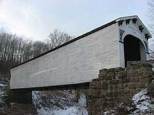

- One of the best preserved covered bridges in the state is Bloomfield's Richland-Plummer Creek Covered Bridge, built by A.M. Kennedy and Sons in 1883. It is located approximately 1 3⁄4 miles south of town. It was listed on the National Register of Historic Places in 1993.[9]
- Near Bloomfield is the Tulip Viaduct.
- Bloomfield is the home of the Shawnee Summer Theater Indiana's oldest continuously running professional summer theater. Shawnee has operated, uninterrupted, since 1960.
- The man who owned the land where Bloomfield was built (Peter Cornelius Van Slyke) is buried in Bloomfield in the Van Slyke cemetery on the west end of town (behind the old woolen mill).
- Shawnee Field is approximately 5 miles west of town.
- Just east of Bloomfield is the source for Walnut Grove premium Spring Water.
Festivals
- Annual Bloomfield Apple Festival and Parade held typically on the first full weekend of October.
- Fireworks held on the 4th of July.
- Annual Town-Wide Yard Sales (the largest in the county) are the Saturday before Father's Day in June.
References
- 1 2 "G001 - Geographic Identifiers - 2010 Census Summary File 1". United States Census Bureau. Retrieved 2015-07-13.
- 1 2 3 "Feature ID 431200". Geographic Names Information System. United States Geological Survey. Retrieved June 30, 2014.
- 1 2 "American FactFinder". United States Census Bureau. Retrieved 2012-12-11.
- ↑ "Incorporated Places and Minor Civil Divisions Datasets: Subcounty Resident Population Estimates: April 1, 2010 to July 1, 2012". United States Census Bureau. Archived from the original on 2013-06-17. Retrieved 2013-06-25.
- 1 2 "FIPS55 Data: Indiana". FIPS55 Data. United States Geological Survey. February 23, 2006. Archived from the original on June 18, 2006. Retrieved June 30, 2014.
- ↑ "Find a County". National Association of Counties. Archived from the original on 2011-05-31. Retrieved 2011-06-07.
- ↑ "Introduction to the Prehistory of Indiana". Kellar, James H. Retrieved 2013-01-23.
- ↑ "Patterns in lithic resource procurement and exploitation among early paleo-Indians of the midwestern United States". Tankersley, Kenneth B. Retrieved 2013-01-23.
- 1 2 National Park Service (2010-07-09). "National Register Information System". National Register of Historic Places. National Park Service.
- ↑ "Greene County Indiana History and Genealogy". County History Preservation Society. Retrieved 2013-01-23.
- ↑ "US Gazetteer files: 2010, 2000, and 1990". United States Census Bureau. 2011-02-12. Retrieved 2011-04-23.
- ↑ "Annual Estimates of the Resident Population for Incorporated Places: April 1, 2010 to July 1, 2015". Retrieved July 2, 2016.
- ↑ "Indiana City/Town Census Counts, 1900 to 2010". STATS Indiana. Indiana Business Research Center. Retrieved June 30, 2014.
- ↑ "American FactFinder". United States Census Bureau. Archived from the original on 2013-09-11. Retrieved 2008-01-31.
External links
| Wikimedia Commons has media related to Bloomfield, Indiana. |
Municipalities and communities of Greene County, Indiana, United States | ||
|---|---|---|
| Cities | ||
| Towns | ||
| Townships | ||
| CDPs | ||
| Other unincorporated communities |
| |
| Footnotes | ‡This populated place also has portions in an adjacent county or counties | |