Winchester, Indiana
| City of Winchester, Indiana | |
|---|---|
| City | |
|
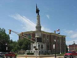
Randolph County Courthouse and veterans' monument in downtown Winchester | |
| Nickname(s): Dub - C (WC), Sugar Cream Pie Capital | |
 Location of Winchester, Indiana | |
 View of Winchester from the air | |
| Coordinates: 40°10′23″N 84°58′39″W / 40.17306°N 84.97750°WCoordinates: 40°10′23″N 84°58′39″W / 40.17306°N 84.97750°W | |
| Country | United States |
| State | Indiana |
| County | Randolph |
| Township | White River |
| Named for | Winchester, Hampshire |
| Government | |
| • Mayor | Shon Byrum (D) |
| Area[1] | |
| • Total | 3.34 sq mi (8.65 km2) |
| • Land | 3.33 sq mi (8.62 km2) |
| • Water | 0.01 sq mi (0.03 km2) |
| Elevation | 1,089 ft (332 m) |
| Population (2010)[2] | |
| • Total | 4,935 |
| • Estimate (2012[3]) | 4,887 |
| • Density | 1,482.0/sq mi (572.2/km2) |
| Time zone | EST (UTC-5) |
| • Summer (DST) | EDT (UTC-4) |
| ZIP code | 47394 |
| Area code(s) | 765 |
| FIPS code | 18-84752[4] |
| GNIS feature ID | 0446166[5] |
| Website | http://www.winchesterindiana.us/ |
Winchester is a city in White River Township, Randolph County, Indiana, United States. The population was 4,935 at the 2010 census. The city is the county seat of Randolph County.[6] It is the home of Winchester Speedway.
History
Winchester was laid out in 1818 as the county seat.[7] A post office has been in operation at Winchester since 1820.[8]
The Gen. Asahel Stone Mansion, Winchester Courthouse Square Historic District, and Winchester Residential Historic District are listed on the National Register of Historic Places.[9][10]
Geography
Winchester is located at 40°10′23″N 84°58′39″W / 40.17306°N 84.97750°W (40.173165, -84.977435).[11]
According to the 2010 census, Winchester has a total area of 3.343 square miles (8.66 km2), of which 3.33 square miles (8.62 km2) (or 99.61%) is land and 0.013 square miles (0.03 km2) (or 0.39%) is water.[1]
Demographics
| Historical population | |||
|---|---|---|---|
| Census | Pop. | %± | |
| 1850 | 532 | — | |
| 1870 | 1,456 | — | |
| 1880 | 1,958 | 34.5% | |
| 1890 | 3,014 | 53.9% | |
| 1900 | 3,705 | 22.9% | |
| 1910 | 4,266 | 15.1% | |
| 1920 | 4,021 | −5.7% | |
| 1930 | 4,487 | 11.6% | |
| 1940 | 5,303 | 18.2% | |
| 1950 | 5,467 | 3.1% | |
| 1960 | 5,742 | 5.0% | |
| 1970 | 5,493 | −4.3% | |
| 1980 | 5,659 | 3.0% | |
| 1990 | 5,095 | −10.0% | |
| 2000 | 5,037 | −1.1% | |
| 2010 | 4,935 | −2.0% | |
| Est. 2015 | 4,769 | [12] | −3.4% |
2010 census
As of the census[2] of 2010, there were 4,935 people, 2,051 households, and 1,281 families residing in the city. The population density was 1,482.0 inhabitants per square mile (572.2/km2). There were 2,349 housing units at an average density of 705.4 per square mile (272.4/km2). The racial makeup of the city was 96.1% White, 0.5% African American, 0.5% Native American, 0.5% Asian, 1.3% from other races, and 1.1% from two or more races. Hispanic or Latino of any race were 2.6% of the population.
There were 2,051 households of which 30.2% had children under the age of 18 living with them, 43.1% were married couples living together, 14.3% had a female householder with no husband present, 5.0% had a male householder with no wife present, and 37.5% were non-families. 32.2% of all households were made up of individuals and 14.9% had someone living alone who was 65 years of age or older. The average household size was 2.32 and the average family size was 2.89.
The median age in the city was 40.2 years. 23.6% of residents were under the age of 18; 8.3% were between the ages of 18 and 24; 23.8% were from 25 to 44; 25.4% were from 45 to 64; and 18.9% were 65 years of age or older. The gender makeup of the city was 47.6% male and 52.4% female.
2000 census
As of the census[4] of 2000, there were 5,037 people, 2,171 households, and 1,350 families residing in the city. The population density was 1,623.8 people per square mile (627.4/km²). There were 2,377 housing units at an average density of 766.3 per square mile (296.1/km²). The racial makeup of the city was 98.31% White, 0.24% African American, 0.26% Native American, 0.30% Asian, 0.32% from other races, and 0.58% from two or more races. Hispanic or Latino of any race were 1.41% of the population.
There were 2,171 households out of which 27.4% had children under the age of 18 living with them, 48.1% were married couples living together, 10.5% had a female householder with no husband present, and 37.8% were non-families. 33.7% of all households were made up of individuals and 16.2% had someone living alone who was 65 years of age or older. The average household size was 2.23 and the average family size was 2.83.
In the city spread out with 22.2% under the age of 18, 8.9% from 18 to 24, 27.4% from 25 to 44, 22.0% from 45 to 64, and 19.6% who were 65 years of age or older. The median age was 40 years. For every 100 females there were 88.7 males. For every 100 females age 18 and over, there were 84.9 males.
The median income for a household in the city was $28,500, and the median income for a family was $37,607. Males had a median income of $28,947 versus $22,226 for females. The per capita income for the city was $17,753. About 10.9% of families and 15.0% of the population were below the poverty line, including 20.2% of those under age 18 and 6.9% of those age 65 or over.
Notable people
- James P. Goodrich, Governor of Indiana, 1917–1921, born in Winchester
- Randy Jo Hobbs, musician born in Winchester
- James Eli Watson, U. S. Senator
- Robert Wise, Hollywood director, born in Winchester
- Greg Leffler, Indy car driver
- Troy Puckett, pitcher for the Philadelphia Phillies in 1911, born in Winchester
- I. Marlene King, creator of the ABC Family original series Pretty Little Liars
References
- 1 2 "G001 - Geographic Identifiers - 2010 Census Summary File 1". United States Census Bureau. Retrieved 2015-07-29.
- 1 2 "American FactFinder". United States Census Bureau. Retrieved 2012-12-11.
- ↑ "Population Estimates". United States Census Bureau. Retrieved 2013-06-25.
- 1 2 "American FactFinder". United States Census Bureau. Retrieved 2008-01-31.
- ↑ "US Board on Geographic Names". United States Geological Survey. 2007-10-25. Retrieved 2008-01-31.
- ↑ "Find a County". National Association of Counties. Retrieved 2011-06-07.
- ↑ Tucker, E. (1882). History of Randolph County, Indiana: With Illustrations and Biographical Sketches of Some of Its Prominent Men and Pioneers : to which are Appended Maps of Its Several Townships. A.L. Klingman. p. 36.
- ↑ "Randolph County". Jim Forte Postal History. Retrieved 1 November 2015.
- ↑ National Park Service (2010-07-09). "National Register Information System". National Register of Historic Places. National Park Service.
- ↑ "National Register of Historic Places Listings". Weekly List of Actions Taken on Properties: 3/21/11 through 3/25/11. National Park Service. 2011-04-01.
- ↑ "US Gazetteer files: 2010, 2000, and 1990". United States Census Bureau. 2011-02-12. Retrieved 2011-04-23.
- ↑ "Annual Estimates of the Resident Population for Incorporated Places: April 1, 2010 to July 1, 2015". Retrieved July 2, 2016.
- ↑ "Census of Population and Housing". Census.gov. Retrieved June 4, 2015.
External links
Municipalities and communities of Randolph County, Indiana, United States | ||
|---|---|---|
| Cities | ||
| Towns | ||
| Townships | ||
| Unincorporated communities |
| |
| Footnotes | ‡This populated place also has portions in an adjacent county or counties | |