Yên Lập District
| Yên Lập District Huyện Yên Lập | |
|---|---|
| Rural district | |
| Country |
|
| Region | Northeast |
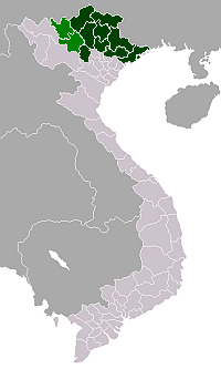
| Province | Phú Thọ |
| Capital | Yên Lập |
| Area | |
| • Total | 169 sq mi (437 km2) |
| Population (2003) | |
| • Total | 79,548 |
| Time zone | UTC + 7 (UTC+7) |
Yên Lập is a rural district of Phú Thọ Province in the Northeast region of Vietnam. As of 2003 the district had a population of .[1] The district covers an area of 437 km². The district capital lies at Yên Lập.[1]
Administrative divisions
Yên Lập, Mỹ Lung, Mỹ Lương, Lương Sơn, Xuân An, Xuân Viên, Xuân Thủy, Hưng Long,Thượng Long, Nga Hoàng, Trung Sơn, Đồng Thịnh, Phúc Khánh, Ngọc Lập, Ngọc Đồng, Minh Hòa, Đồng Lạc.
References
- 1 2 "Districts of Vietnam". Statoids. Retrieved March 23, 2009.
Coordinates: 21°25′01″N 104°57′00″E / 21.417°N 104.950°E
This article is issued from Wikipedia - version of the 10/17/2013. The text is available under the Creative Commons Attribution/Share Alike but additional terms may apply for the media files.