Cao Bằng Province
| Cao Bằng Province Tỉnh Cao Bằng | |
|---|---|
| Province | |
 | |
| Nickname(s): High Plateau | |
 Location of Cao Bằng within Vietnam | |
| Coordinates: 22°40′N 106°0′E / 22.667°N 106.000°ECoordinates: 22°40′N 106°0′E / 22.667°N 106.000°E | |
| Country |
|
| Region | http://www.northeastvietnam.com[ Northeast (Vietnam) |
| Capital | Cao Bằng |
| Area | |
| • Total | 6,724.6 km2 (2,596.4 sq mi) |
| Population (2008) | |
| • Total | 528,100 |
| • Density | 79/km2 (200/sq mi) |
| Demographics | |
| • Ethnicities | Tày, Nùng, Dao, H'Mông, Vietnamese, Hoa, Sán Chay |
| Time zone | ICT (UTC+7) |
| Calling code | 26 |
| ISO 3166 code | VN-04 |
| Website | www.caobang.gov.vn |
Cao Bằng (![]() listen) is a province of the Northeast region of Vietnam. The province has borders with Hà Giang, Tuyên Quang, Bắc Kạn, and Lạng Sơn provinces within Vietnam. It also has common international border with Guangxi Province of the People's Republic of China. The province covers an area of 6,724.6 square kilometres, and, as of 2008, its population was 528,100 people.[1]
listen) is a province of the Northeast region of Vietnam. The province has borders with Hà Giang, Tuyên Quang, Bắc Kạn, and Lạng Sơn provinces within Vietnam. It also has common international border with Guangxi Province of the People's Republic of China. The province covers an area of 6,724.6 square kilometres, and, as of 2008, its population was 528,100 people.[1]
The area has a rich history tracing to the Bronze Age of the Tày Âu Kingdom in Vietnam. The dynasties which ruled the area were Tày lords, Be Khac Thieu and Nag Dac Thai. The province is in the region where the Vietnamese people lived thousands of years ago before their southwards expansion. Cao Bằng has several points of historical interest as well as many natural features such as the Pác Bó (at the mouth of the confluence of two rivers, the Bằng Giang and Hien rivers) where Hồ Chí Minh in January 1941 established a revolutionary force at Cốc Bó cave, the Mạc emperor's Temple, the Kỳ Sầm Temple, Coi Bin Church, the Bản Giốc waterfall area at the international border between Vietnam and China, and the Thang Hen Mountain Lake.
History
Cao Bằng's proximity to China has meant that it has had a somewhat turbulent history, having changed hands a number of times.
The kingdom of Văn Lang went through a series of changes with turbulent history, having changed hands a number of times and the Âu Việt came to existence with Cao Bằng as its capital.[2] The Âu Việt were a conglomeration of upland tribes living in what is today the mountainous region of northernmost Vietnam, western Guangdong, and southern Guangxi, China, since at least the 3rd century BC. Their capital was located in what is today Cao Bằng Province of northeastern Vietnam.[2]
What are now the Vietnamese provinces of Cao Bằng and Lạng Sơn were known as châu Quảng Nguyên during the time of the Lý and Trần Dynasties. Quảng Nguyên became part of Đại Việt (as Vietnam was called as the time) in 1039, when Emperor Lý Thái Tông expelled Nùng Trí Cao, a Nùng leader, from the area.[3]
Cao Bằng history can be traced to the Bronze Age when the Tày Au Kingdom flourished. They had shifted their capital to Co Loa in Red River Delta but the Vietnamese culture dominated. The Kings fortified their territory around the 10th century due to its proximity to the Chinese border. The feudal dynasties that ruled the area were Tay lords, Be Khac Thieu and Nga Dac Thai. In the 1430s, the Lê Dynasty had many rebellions. Royalty faced strong revolt during the 16th and early part of 17th century – Mac Dang Dung initially occupied the territory and the Lê throne in 1527. However, the Lê kings were reinstated in 1592. Still, the war for control of the region continued and Mac family had the upper hand as they declared it an independent region and ruled for 75 years. As witness to this period, here lie ruins of a temple, which was also the palace of the Mac Kings. It can be seen in the town of Cao Bình, which is located about 12 kilometres (7.5 mi) north of the town of Cao Bằng. Cao Bình was a prominent administrative town until the French occupied the territory; the capital was shifted to the Cao Bằng peninsula when the French conquered the area in 1884. They fortified the town with a fort on a hill overlooking the town (ruins of this fort are seen even now). This fort area is now a high security zone of the People’s Army of Vietnam.[2][3]
Cao Bằng has a long history of revolutionaries and nationalists. The significant history of the peninsula to the present regime is recorded from the 1920s when it became the "cradle of the revolutionary movement in the north". Many pro-independence groups based themselves in the mountains. The Communist Party of Vietnam chose the province as a base, using the rough terrain as protection. Its historicity was further accentuated when Hồ Chí Minh, on his return from China in exile in 1941, made his headquarters at Pắc Bó, in Trường Hà commune, Hà Quảng District, 56 kilometres (35 mi) north of Cao Bằng for the decisive revolutionary movement between 1940 and 1945.[4]
In 1950, the province had 10 districts: Bảo Lạc, Hạ Lang, Hòa An, Nguyên Bình, Phú Thạch, Phục Hòa, Quảng Uyên, Thạch An, Trấn Biên and Trùng Khánh. In 1958, Trấn Biên was renamed Trà Lĩnh. The district of Thông Nông was created out of part of the district of Hà Quảng by Decision 67-CP on 7 April 1966. The districts of Phục Hòa and Quảng Uyên were merged to become Quảng Hòa by Decision 27-CP on 8 March 1967. The district of Hạ Lang was abolished and integrated into the districts of Quảng Hòa and Trùng Khánh by Decision 176-CP on 15 September 1969.[2][3]
In December 1978, the two districts of Ngân Sơn and Chợ Rã were transferred from the province of Bắc Thái to Cao Bằng by a decree of the congress of the Communist Party. This meant that Cao Bằng had 11 districts: Bảo Lạc, Hà Quảng, Hòa An, Nguyên Bình, Quảng Hòa, Thạch An, Thông Nông, Trà Lĩnh, Trùng Khánh, Ngân Sơn and Chợ Rã. The district of Chợ Rã was renamed Ba Bể by Decision 144-HĐBT on 6 November 1984.[3]
On 27 February 1979, during the Sino-Vietnamese War, Chinese infantry entered the city of Cao Bằng and occupied it, inflicting a "scorched earth" policy by levelling most of the city, including places of worship.[5] The historical areas near the Pác Bó caves in the commune of Trường Hà in Hà Quảng district were mined and bombed, demolishing most of the cave mouth where Hồ Chí Minh based his guerrilla activities in the 1940s and 1950s. In 1996, the districts of Ngân Sơn and Ba Bể were transferred into the newly created province of Bắc Kạn. The district of Bảo Lâm was created by carving out a portion of Bảo Lạc District, in accordance with Decree 52/2000/NĐ-CP on 25 September 2000.[2][3]
Geography
Cao Bằng Province located in the northern part of the country has borders with Hà Giang, Tuyên Quang, Bắc Kạn, and Lạng Sơn provinces within Vietnam. It also has a common international border (322 kilometres (200 mi) long) with the Guangxi province of the People's Republic of China. The main town is also named Cao Bằng.[6]
The geographical setting of the province is mostly mountainous, with land available for habitation thus being limited. The average temperature reported in the province is 22 °C (72 °F). Winter temperatures in some areas occasionally experience freezing conditions and some amount of snowfall. The Bản Giốc Waterfall which is on the border with China is a well known natural feature in the province.[6] The western side of Cao Bằng borders Tuyên Quang and Hà Giang Provinces. The southern side of Cao Bằng borders the provinces of Bắc Kạn and Lạng Sơn. The north-west expanse of the province is 80 kilometres (50 mi), from Trọng Con in Thạch An district to Đức Hạnh in Bảo Lâm district). It stretches 170 kilometres (110 mi) from east to west, from Quảng Lâm in Bảo Lâm district to Lý Quốc in Hạ Lang district. Cao Bằng has an area of 6,724.6 square kilometres (2,596.4 sq mi) (2008 figures). Mountainous forests take up more than 90% of the province.
The Peninsular valley of the Cao Bằng Province is formed between the Bang Giang and Hien rivers. The two rivers confluence to the northwest of the town. In the war with China the town was damaged in 1979 and has been since rebuilt. The market in Cao Bằng town is believed to be the largest in Vietnam.[7] Cao Bằng town is located on Highway 3 and is 270 kilometres (170 mi) from Hanoi. The road from Nao Pac to Cao Bằng passes through the Cao Bắc Pass. Since the elevation of the town is 300 metres (980 ft) it has salubrious temperate climate throughout the year.[7]
Demographics
The province of Cao Bằng is home to many people belonging to Vietnam's ethnic minority groups. The most notable of these are the Tày, Nùng, Dao, and Hmong.
According to the General Statistics Office of the Government of Vietnam, the population of Cao Bằng province as of 2008 was 528,100 with a density of 79 persons per km2 over a total land area of 6,724.6 square kilometres (2,596.4 sq mi) of the province. It is one of the least populated provinces in the Northern midlands and mountain areas of Vietnam.[8] The male population during this period was 256,300[9] with females accounting for 271,800.[10] The rural population was 445,100 against an urban population of 83,000.[11][12]
Languages spoken in Cao Bằng province include the following.
- Hmong-Mien languages
- Hmong
- Kim Mun
- Tai languages
- Tày Bảo Lạc - Bảo Lạc District
- Tày Trùng Khánh - Trùng Khánh District
- Nùng An - Quảng Uyên District
- Nùng Giang - Hà Quảng District
- Giáy - Bảo Lạc District
- Kra languages
- En (Nùng Vên) - Hà Quảng District
- Tibeto-Burman languages
- Black Lolo - Bảo Lạc District
Administrative divisions
Cao Bằng is subdivided into 13 district-level sub-divisions:
- 12 districts:
- 1 provincial city:
- Cao Bằng (capital)
They are further subdivided into 14 commune-level towns (or townlets), 181 communes, and 4 wards.[13]
Table of local government divisions
| Name | Division type | Population (2003) | Area (km²) | Towns (huyện lỵ or thị trấn) (bold) and communes (xã) |
|---|---|---|---|---|
| Cao Bằng | Township (thị xã) | 51,386[14] | 55[14] | Wards (phường): Hợp Giang, Tân Giang, Sông Bằng, Sông Hiến, Hoà Chung, Ngọc Xuân, Duyệt Chung, Đề Thám Communes (xã): Hưng Đạo, Vĩnh Quang, Chu Trinh |
| Bảo Lạc District | District (huyện) | 47,019[14] | 919[14] | Bảo Lạc, Sơn Lộ, Đình Phùng, Hưng Đạo, Huy Giáp, Hồng An, Xuân Trường, Khánh Xuân, Phan Thanh, Hồng Trị, Cô Ba, Bảo Toàn, Cốc Pàng, Thượng Hà, Hưng Thịnh, Sơn Lập, Kim Cúc |
| Bảo Lâm District | District (huyện) | 107,279[14] | 1457[14] | Pác Miầu, Mông Ân, Thái Học, Thái Sơn, Nam Cao, Nam Quang, Tân Việt, Yên Thổ, Quảng Lâm, Thạch Lâm, Lý Bôn, Đức Hạnh, Vĩnh Quang, Vĩnh Phong |
| Hạ Lang District | District (huyện) | 26,330[14] | 463[14] | Hạ Lang, Thị Hoa, Thái Đức, Cô Ngân, Vinh Quý, Việt Chu, Quang Long, An Lạc, Kim Loan, Đức Quang, Thắng Lợi, Minh Long, Đồng Loan, Lý Quốc, Thanh Nhật |
| Hà Quảng District | District (huyện) | 34,113[14] | 454[14] | Sóc Hà, Trường Hà, Kéo Yên, Lũng Nặm, Vân An, Cải Viên, Tổng Cọt, Nội Thôn, Hồng SĨ, Sĩ Hai, Mã Ba, Hạ Thôn, Phù Ngọc, Đào Ngạn, Xuân Hoà, Quý Quân, Nà Sac, Thượng Thôn, Vần Dính |
| Hòa An District | District (huyện) | 72,104[14] | 656[14] | Nước Hai, Dân Chủ, Đức Long, Công Trừng, Trương Lương, Bình Long, Nam Tuấn, Đại Tiến, Đức Xuân, Ngũ Lão, Bế Triều, Hồng Việt, Hoàng Tung, Bình Dương, Bạch Đằng, Lê Chung, Hà Trì, Quang Trung, Nguyễn Huệ |
| Nguyên Bình District | District (huyện) | 39,153[14] | 837[14] | Nguyên Bình, Tĩnh Túc, Thịnh Vượng, Hoa Thám, Lang Môn, Tam Kim, Hưng Đạo, Quang Thành, Thành Công, Phan Thanh, Mai Long, Ca Thành, Vũ Nông, Yên Lạc, Triệu Nguyên, Thể Dục, Thái Học, Minh Thanh, Bắc Hợp, Minh Tâm |
| Phục Hòa District | District (huyện) | 102,974 [14] | 263[14] | Hòa Thuận, Tà Lùng, Mỹ Hưng, Hồng Đại, Cách Linh, Triệu Ẩu, Đại Sơn, Tiên Thành, Lương Thiện |
| Quảng Uyên District | District (huyện) | 42,544[14] | 383[14] | Quảng Uyên, Bình Lăng, Cai Bộ, Chí Thảo, Đoài Khôn, Độc Lập, Hồng Định, Hạnh Phúc, Hồng Quang, Hoàng Hải, Phúc Sen, Phi Hải, Quốc Phong, Quảng Hưng, Quốc Dân, Tự Do, Ngọc Động |
| Thạch An District | District (huyện) | 31,942[14] | 683[14] | Đông Khê, Đức Long, Danh Sĩ, Lê Lợi, Đức Xuân, Trọng Con, Lê Lai, Thụy Hùng, Thị Ngân, Vân Trình, Thái Cương, Đức Thông, Quang Trọng, Minh Khai, Canh Tân, Kim Đồng |
| Thông Nông District | District (huyện) | 23,116[14] | 360[14] | Thông Nông, Bình Lãng, Thanh Long, Lương Can, Yên Sơn, Đa Thông, Lương Thông, Vị Quang, Cần Yên, Cần Nông, Ngọc Động |
| Trà Lĩnh District | District (huyện) | 21,600[14] | 257[14] | Hùng Quốc, Tri Phương, Cô Mười, Quang Hán, Quang Vinh, Lưu Ngọc, Cao Chương, Quốc Toản, Xuân Nội, Quang Trung |
| Trùng Khánh District | District (huyện) | 50,189[14] | 469[14] | Trùng Khánh, Đàm Thủy, Chí Viễn, Phong Châu, Cao Thăng, Đoàn Côn, Thân Giáp, Thông Huề, Đức Hồng, Trung Phúc, Cảnh Tiên, Đình Minh, Đình Phong, Ngọc Khê, Ngọc Chung, Phong Nậm, Lăng Yên, Khâm Thành, Lăng Hiếu |
Economy
Cao Bằng is relatively poor compared to other Vietnamese provinces. Most of the province's economy is centered on agriculture and forestry, although other industries exist. Facilities such as schools and hospitals tend to be in poor condition, but are gradually improving. Transportation, once a major problem, has been improved considerably by new road construction.
As against the national figure of 7,592 of Agriculture, Forestry and Fishery cooperatives there are only 4 cooperatives in the province; all are agricultural cooperatives.[15][16] There are only 57 farms compared to the national total of 120,699.[17]
The output value of agriculture produce at constant 1994 prices in the province was 676.6 billion đồngs against the national value of 156,681.9 billion dongs.[18] In 1994 the province produced 151,800 tonnes of cereals compared to the national production of 229.1 million tonnes [19] The per capita production of cereals in the district was 448.6 kg as against the national figure of 501.8 kg in 2007.[20] In 2007, the industrial output of the province was a meagre 571.8 billion dongs against the national output of 1.47 million billion dongs.[21]
Attractions
As the province is in the region where the Vietnamese people lived thousands of years ago before their southwards expansion, Cao Bằng has several points of historical interest as well as many natural features.
- Pác Bó
Pác Bó, located at the mouth of the confluence of two rivers namely Bang Giang and Hien rivers. Its historicity is due to the fact that Hồ Chí Minh, on his return from China (where he had lived for 30 years) on 28 January 1941 established a revolutionary force at a cave near Pác Bó valley inhabited by the Nung tribes. He organized the revolutionary movement by training the cadres, translated the History of Communist Party in the USSR into the Vietnamese language and also edited a revolutionary news paper called the 'Independent Vietnam' from Pác Bó. The Vietnam Independence League (Vietnam Doc Lap Dong Minh Hoi) known by its short form as Viet Minh was established here during the Eighth Congress of the Communist Party Central Committee held at Pác Bó from 10–19 March 1941. Between 1941 and 1945 until the Japanese left was a period of great turmoil in Vietnam. The Japanese set up King Bai as the head of state to counter the influence of the French government and the Viet Minh had established themselves their rule in six provinces in North Vietnam in the Red River delta. Following the surrender of Japan on 13 August 1945 in World War II, Hồ Chí Minh had expanded the ambit of his "August revolution" to Hanoi, Huế and Saigon, and the king abdicated. Hồ Chí Minh declared the independence of Vietnam and addressed the nation from Hanoi on 2 September 1945. The Pac ba Vestiges Area Exhibition Centre has an array of display of artifacts of the revolution with a Ho Chi Minh House of Remembrance. A stream and a hill near Pác Bó were named as "Lenin Stream" and "Karl Marx Mountains".[22]
- Kỳ Sầm Temple
Kỳ Sầm Temple was built as a memorial at Nung village (200 metres (660 ft) east of Highway 203) of Ngan in honour of Nùng Trí Cao, Nùng Lord of Quảng Uyên for organizing the ethnic minority revolt in the 11th century against the Vietnamese monarchy. The first effort at rebellion against the King Lê Thai Tong was started by Nùng Trí Cao's father, Nùng Ton Phuc, and elder brother, Nùng Trí Thong. This failed and both were caught and executed. Two years later Cao mobilised rebellion army and captured the territory and declared himself as the king of the Nùng Kingdom and named it as Dai Lich. However, this occupancy was short-lived as he was captured by Viet forces. He was, however, let go by the King and allowed to return to Quảng Uyên. Six years later he again launched a rebellion against the king in 1048 and captured the territory in southern China and declared himself as the "Emperor of Dai Nam." His kingdom survived for 5 years by manipulation of the King of China and the King of Viet. However, in 1053 the Vietnamese king Lê Thai Tong captured Cao and executed him. The temple built in his honour, though ancient, is now a refurbished monument (renovated in the 19th century) consisting of two buildings. The outer building has the altar of one of his generals and the inner shrine housed the images of Cao, his wife and his mother till they were stolen a few years ago. An inscription still seen here narrates Cao's war exploits and his avowed commitment to the cause of his nation.[23]
- Coi Binh Church
Coi Binh Church is one of the three churches that was built in 1906 by the French; the other two are at Cao Bằng and That Khe. Except for the Vicar's house the rest of the residential buildings around the church were destroyed in 1979. The vicarage is now the venue of "Cao Bằng region's most famous apiaries".[24]
- Mac King's Temple
Mac King's Temple is the 16th-century palace of the Mạc Dynasty. It is located on a hill top above the Lang Den (meaning the "Temple Village"). It is located on the west bank of the Dau Gen River, which is a tributary of the Bang Giang River. The construction of this palace is credited to a general of the Le Army in 1521–1522 after he forcibly dethroned the 11 year King Lê Chieu Tong, exiled him and installed his brother Lê Thung as the king. However, two years later Lê Chieu Tong was reinstalled as the King of Đại Việt. The Mạc Dynasty then ruled for 65 years. The Lê dynasty continued to fight the Mac Kings and finally succeeded to regain power in 1592 for a short time with the help of the powerful Trin family. A nephew of Mac Mau Hop took control of Cao Bằng and three generations of his family ruled for 75 years till the armies of the Trin family captured Cao Bằng in 1667. The small palace building has canons placed near the main entranc even nowe.[24]
Nature
Cao Bằng, which lies on the Quây Sơn River, in Ngọc Khê commune, in Trùng Khánh district has many mountains, forests, rivers and springs throughout. The area near Bản Doc Waterfall is a well known scenic tourist site. The city of Cao Bằng had many buildings of World War II vintage of French design, which were in ruins, but since rebuilt. There is an 'Exhibition Centre' in the town where the history of the revolutionary struggle in Vietnam, which originated in this province, is displayed along with Hồ Chí Minh's vintage car, bearing the registration number "BAC 808".[7]
- Bản Giốc waterfall
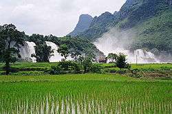
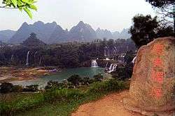
Bản Giốc Waterfalls are located 80 kilometres (50 mi) north of Cao Bằng at the Vietnam-China International Border. It originates from the Quy Xuan River and falls over a height of 30 metres (98 ft) and is300 metres (980 ft)wide At the top, the waterfall is seen in three parts divided by rocks and trees. As the water falls down the cliff and merges with sunlight, a seven-coloured rainbow formation is witnessed. Many green trees and flowers that perfume the air are located at the base of the fall.[25][26]
The Bản Giốc waterfall area at the international border between Vietnam and China is stated to be "among areas having a borderline defined on rivers and streams". It has been clarified by the Head of the Border Committee that the borderline of the fall shall be as fixed along the median of the main flow which shall be done jointly by both sides.[27] Even though in Vietnam the two falls are considered as one fall with the name Bản Giốc, the physical fact is that the water fall is named under two ownership divisions namely, "Detian - Banyue Falls" (Chinese: 德天瀑布 & 板約瀑布) or "Ban Gioc Falls" (Vietnamese: thác Bản Giốc).[Note 1][28]
This water fall is the 4th largest waterfall along a national border in the world, the other three are Iguazu Falls, Victoria Falls, and Niagara Falls, in that order. It was also one of the crossing points for China's army during the brief Sino-Vietnamese War. Nearby there is the Tongling Gorge accessible only through a cavern from an adjoining gorge. Rediscovered only recently, it has many species of endemic plants, found only in the gorge. This cave was a hideout for the local bandits whose treasure is occasionally still found in the cliff-side caves. Ban Gioc Fall is also famous for the fish species "tram huong." During the 1920s, this was a hunting and fishing location for the French who built cottages for the purpose.[29]
- Pác Bó Cave
Pác Bó Cave is the cave where Ho Chi Minh lived on his return from China and launched his revolutionary movement.[30]
- Thang Hen Mountain lake
Thang Hen Mountain lake, in Trà Lĩnh district, consists of 36 small natural lakes located on the top of a hill at 1,000 metres (3,300 ft) elevation. The lakes have been created in limestone formations and some of them flow out as steams. An unusual feature of the lakes is that their water level fluctuates like the tides of the seas, which phenomenon is attributed to the springs of water emerging from artesian wells in lime stone formations. The lakes flow through the river, which eventually becomes the Ban Gioc waterfall.[26]
Notes
- ↑ The two falls have separate names in Chinese: Dé Tiān=德天=Đức Thiên;Bǎn Yuē=板約=Bản Giốc. However, in Vietnamese, the two falls are considered as two parts of one waterfall with the sole name Bản Giốc.
References
- ↑ "Population and population density in 2008 by province". General Statistics Office of Vietnam. Retrieved 5 September 2010.
- 1 2 3 4 5 Chapuis, Oscar (1995). A history of Vietnam: from Hong Bang to Tu Duc. Rulers of Vietnam. Greenwood Publishing Group. pp. 11–13. ISBN 0-313-29622-7. Retrieved 2010-07-02.
- 1 2 3 4 5 "Cao Bang Province". Cambodia Travel Key and Foot Print Vietnam. Retrieved 2010-08-30.
- ↑ Boobbyer, pp. 133–135
- ↑ "Chinese Invasion of Vietnam, February 1979". Global Security.org. Retrieved 2010-08-27.
- 1 2 "Geography". Museum of Learning. Retrieved 2010-06-28.
- 1 2 3 Boobbyer, Claire (2008). Footprint Vietnam. Footprint Travel Guides. pp. 134–36. ISBN 1-906098-13-1. Retrieved 2010-07-02.
- ↑ "Population and population density in 2008 by province". General Statistics Office of the Government of Vietnam. Retrieved 2010-06-23.
- ↑ "Population and Employment :Average male population by province". Population and Employment: General Statistics Office of the Government of Vietnam. Retrieved 2010-06-23.
- ↑ "Average female population by province". General Statistics Office of the Government of Vietnam. Retrieved 2010-06-23.
- ↑ "Average urban population by province". Population and Employment: General Statistics Office of the Government of Vietnam. Retrieved 2010-06-23.
- ↑ "Average rural population by province". Population and Employment: General Statistics Office of the Government of Vietnam. Retrieved 2010-06-23.
- ↑ "Administrative Unit, Land and Climate: Number of administrative units as of 31 December 2008 by province". General Statistics Office of the Government of Vietnam. Retrieved 2010-06-26.
- 1 2 3 4 5 6 7 8 9 10 11 12 13 14 15 16 17 18 19 20 21 22 23 24 25 26 "Districts of Vietnam". Statoids. Retrieved June 20, 2010.
- ↑ "Agriculture, Forestry and Fishery: Number of cooperatives by province". Population and Employment :General Statistics Office of the Government of Vietnam. Retrieved 2010-06-23.
- ↑ "Number of cooperatives in 2008 by kind of activity and by province: Agriculture, Forestry and Fishery". Population and Employment: General Statistics Office of the Government of Vietnam. Retrieved 2010-06-23.
- ↑ "Agriculture, Forestry and Fishery: Number of farms by province". Population and Employment: General Statistics Office of the Government of Vietnam. Retrieved 2010-06-23.
- ↑ "Agriculture, Forestry and Fishery :Output value of agriculture at constant 1994 prices". Population and Employment: General Statistics Office of the Government of Vietnam. Retrieved 2010-06-23.
- ↑ "Agriculture, Forestry and Fishery:Production of cereals by province". Population and Employment: General Statistics Office of the Government of Vietnam. Retrieved 2010-06-23.
- ↑ "Agriculture, Forestry and Fishery: Production of cereals per capita by province". Population and Employment: General Statistics Office of the Government of Vietnam. Retrieved 2010-06-23.
- ↑ "Industry: Industrial output value at current prices by province". Population and Employment: General Statistics Office of the Government of Vietnam. Archived from the original on 2009-08-31. Retrieved 2010-06-23.
- ↑ Boobbyer, pp. 135–136
- ↑ Boobbyer, p. 134
- 1 2 Boobbyer, p. 135
- ↑ "Vietnam Destinations: Ban Gioc (Cao Bang) travel tours information". Archived from the original on 2007-02-17. Retrieved 2010-07-02.
- 1 2 "Cao Bang - the land of mountains and water". English Vietnamvnet. Archived from the original on March 1, 2009. Retrieved 2010-07-02.
- ↑ "On the settlement of Vietnam-China border issue". Vietnam Embassy. 2002-09-16. Retrieved 2010-07-02.
- ↑ "Cao Bằng". triphanoi.com. Retrieved 2007-02-12.
- ↑ "Ban Gioc Waterfall – the largest one in Vietnam!". Vietnam Beauty.com. Retrieved 2010-07-02.
- ↑ Boobbyer, p.136
- Cœdès, George. (1966). The Making of South East Asia (illustrated, reprint ed.). University of California Press. ISBN 0520050614. Retrieved 7 August 2013.
External links
 |
Guangxi, |
| ||
| Hà Giang Province | |
|||
| ||||
| | ||||
| Bắc Kạn Province | Lạng Sơn Province |