Union County, Tennessee
| Union County, Tennessee | |
|---|---|
 Union County Courthouse in Maynardville | |
|
Location in the U.S. state of Tennessee | |
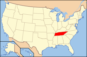 Tennessee's location in the U.S. | |
| Founded | 1850 |
| Named for | Either its creation from parts of five other counties or its support for the Union during the Civil War[1] |
| Seat | Maynardville |
| Largest city | Maynardville |
| Area | |
| • Total | 247 sq mi (640 km2) |
| • Land | 224 sq mi (580 km2) |
| • Water | 24 sq mi (62 km2), 9.5% |
| Population (est.) | |
| • (2015) | 19,119 |
| • Density | 85/sq mi (33/km²) |
| Congressional district | 3rd |
| Time zone | Eastern: UTC-5/-4 |
| Website |
www |
Union County is a county located in the U.S. state of Tennessee. As of the 2010 census, the population was 19,109.[2] Its county seat is Maynardville.[3]
Union County is included in the Knoxville, TN Metropolitan Statistical Area.
History
Union County was formed in 1850 from portions of Grainger, Claiborne, Campbell, Anderson and Knox counties. There are at least two theories on the source of its name. The name may commemorate the "union" of sections of five counties, or it may reflect East Tennessee's support for the preservation of the Union in the years before the Civil War.[4] The county seat was originally named "Liberty," but renamed "Maynardville" in honor of attorney and congressman, Horace Maynard, who had defended the county in a court case that sought to block its formation.[1]
In the 1930s, the damming of the Clinch River by Norris Dam to form Norris Lake inundated a large part of the county,[5] including the community of Loyston, and displaced many residents. With assistance from the National Park Service and the Civilian Conservation Corps (CCC), the Tennessee Valley Authority (TVA) developed Big Ridge State Park as a demonstration park on the shore of the lake in Union County. The park's recreational facilities opened in May 1934.[6]
Geography
According to the U.S. Census Bureau, the county has a total area of 247 square miles (640 km2), of which 224 square miles (580 km2) is land and 24 square miles (62 km2) (9.5%) is water.[7] The county is situated in the Ridge-and-Valley Appalachians, a range characterized by long, narrow ridges alternating with similarly-shaped valleys. Prominent ridges in Union County include Copper Ridge, Hinds Ridge and Lone Mountain. The southern end of Clinch Mountain forms part of the county's border with Grainger County to the east.

The Clinch River, Union County's primary stream, flows through the northern part of the county. This section of the river is part of Norris Lake. Big Ridge Dam, a small non-generating dam, impounds an inlet of Norris Lake, creating Big Ridge Lake at Big Ridge State Park. The "Loyston Sea," one of the widest sections of Norris Lake, is located in Union County just north of the state park.[8]
Adjacent counties
- Claiborne County (north)
- Grainger County (east)
- Knox County (south)
- Anderson County (southwest)
- Campbell County (northwest)
State protected areas
- Big Ridge State Park
- Chuck Swan State Forest (part)
Demographics
| Historical population | |||
|---|---|---|---|
| Census | Pop. | %± | |
| 1860 | 6,117 | — | |
| 1870 | 7,605 | 24.3% | |
| 1880 | 10,260 | 34.9% | |
| 1890 | 11,459 | 11.7% | |
| 1900 | 12,894 | 12.5% | |
| 1910 | 11,414 | −11.5% | |
| 1920 | 11,615 | 1.8% | |
| 1930 | 11,371 | −2.1% | |
| 1940 | 9,030 | −20.6% | |
| 1950 | 8,670 | −4.0% | |
| 1960 | 8,498 | −2.0% | |
| 1970 | 9,072 | 6.8% | |
| 1980 | 11,707 | 29.0% | |
| 1990 | 13,694 | 17.0% | |
| 2000 | 17,808 | 30.0% | |
| 2010 | 19,109 | 7.3% | |
| Est. 2015 | 19,119 | [9] | 0.1% |
| U.S. Decennial Census[10] 1790-1960[11] 1900-1990[12] 1990-2000[13] 2010-2014[2] | |||

At the 2000 census,[15] there were 17,808 people, 6,742 households and 5,191 families residing in the county. The population density was 80 per square mile (31/km²). There were 7,916 housing units at an average density of 35 per square mile (14/km²). The racial makeup of the county was 98.46% White, 0.10% Black or African American, 0.23% Native American, 0.16% Asian, 0.02% Pacific Islander, 0.17% from other races, and 0.86% from two or more races. 0.79% of the population were Hispanic or Latino of any race.
There were 6,742 households of which 35.40% had children under the age of 18 living with them, 62.20% were married couples living together, 10.50% had a female householder with no husband present, and 23.00% were non-families. 19.80% of all households were made up of individuals and 7.40% had someone living alone who was 65 years of age or older. The average household size was 2.62 and the average family size was 2.99.
25.70% of the population were under the age of 18, 8.90% from 18 to 24, 31.00% from 25 to 44, 23.60% from 45 to 64, and 10.80% who were 65 years of age or older. The median age was 36 years. For every 100 females there were 98.80 males. For every 100 females age 18 and over, there were 96.60 males.
The median household income was $27,335 and the median family income was $31,843. Males had a median income of $26,436 versus $18,665 for females. The per capita income for the county was $13,375. About 16.80% of families and 19.60% of the population were below the poverty line, including 25.10% of those under age 18 and 27.80% of those age 65 or over.
Education
- Big Ridge Elementary School
- Horace Maynard Middle School (previously Horace Maynard High School until 1997)
- Luttrell Elementary School
- Maynardville Elementary School
- Paulette Elementary School
- Sharps Chapel Elementary School
- Union County Alternative Center Grades 6-12
- Union County High School
Attractions
- Roy Acuff Museum
Communities
Cities
- Luttrell
- Maynardville (county seat)
- Plainview
Unincorporated communities
Ghost town
Notable people
- Roy Acuff, entertainer
- Chet Atkins, entertainer
- Jake Butcher, former banker and politician, convicted of fraud
- Kenny Chesney, entertainer
- John Rice Irwin, historian and founder of Museum of Appalachia
- Florence Reece, who wrote the song "Which Side Are You On?", was born in Sharps Chapel in 1900.
- Carl Smith, entertainer
See also
References
- 1 2 Bonnie Heiskell Peters, "Union County," Tennessee Encyclopedia of History and Culture. Retrieved: 19 April 2013.
- 1 2 "State & County QuickFacts". United States Census Bureau. Retrieved December 7, 2013.
- ↑ "Find a County". National Association of Counties. Retrieved 2011-06-07.
- ↑ Origins Of Tennessee County Names, Tennessee Blue Book, 2005-2006, page 513
- ↑ History, Union County Chamber of Commerce website, accessed December 5, 2009
- ↑ America from the Great Depression to World War II: Black-and-White Photographs from the FSA-OWI, 1935-1945, LC-USW33- 015718-C
- ↑ "2010 Census Gazetteer Files". United States Census Bureau. August 22, 2012. Retrieved April 14, 2015.
- ↑ Michelle Gibson, "Waterside at Norris Lake," Knoxnews.com, 16 May 2008. Retrieved: 7 November 2013.
- ↑ "County Totals Dataset: Population, Population Change and Estimated Components of Population Change: April 1, 2010 to July 1, 2015". Retrieved July 2, 2016.
- ↑ "U.S. Decennial Census". United States Census Bureau. Retrieved April 14, 2015.
- ↑ "Historical Census Browser". University of Virginia Library. Retrieved April 14, 2015.
- ↑ Forstall, Richard L., ed. (March 27, 1995). "Population of Counties by Decennial Census: 1900 to 1990". United States Census Bureau. Retrieved April 14, 2015.
- ↑ "Census 2000 PHC-T-4. Ranking Tables for Counties: 1990 and 2000" (PDF). United States Census Bureau. April 2, 2001. Retrieved April 14, 2015.
- ↑ Based on 2000 census data
- ↑ "American FactFinder". United States Census Bureau. Retrieved 2011-05-14.
External links
| Wikimedia Commons has media related to Union County, Tennessee. |
- Official site
- Union County Chamber of Commerce
- Union County Public Schools
- TNGenWeb
- Union County at DMOZ
 |
Campbell County | Claiborne County | | |
| |
Grainger County | |||
| ||||
| | ||||
| Anderson County | Knox County |
Municipalities and communities of Union County, Tennessee, United States | ||
|---|---|---|
| Cities | ||
| Unincorporated communities | ||
| Ghost town | ||
| Principal City |  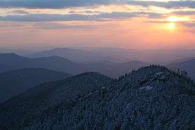 | |
|---|---|---|
| Other Cities | ||
| Counties | ||
Coordinates: 36°17′N 83°50′W / 36.28°N 83.84°W