Trousdale County, Tennessee
| Trousdale County, Tennessee | |
|---|---|
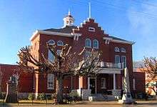 Trousdale County Courthouse in Hartsville | |
|
Location in the U.S. state of Tennessee | |
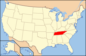 Tennessee's location in the U.S. | |
| Founded | September 5, 1870[1] |
| Named for | William Trousdale[2] |
| Seat | Hartsville |
| Largest town | Hartsville |
| Area | |
| • Total | 117 sq mi (303 km2) |
| • Land | 114 sq mi (295 km2) |
| • Water | 2.5 sq mi (6 km2), 2.1% |
| Population (est.) | |
| • (2015) | 8,042 |
| • Density | 69/sq mi (27/km²) |
| Congressional district | 6th |
| Time zone | Central: UTC-6/-5 |
| Website |
www |
Trousdale County, also known as Hartsville/Trousdale County,[3] is a county located in the U.S. state of Tennessee. As of the 2010 census, the population was 7,870.[4] Its county seat is Hartsville,[5] with which it shares a uniquely formed consolidated city-county government. With an area of just 117 square miles (300 km2), it is Tennessee's smallest county.
Trousdale County is part of the Nashville-Davidson–Murfreesboro–Franklin, TN Metropolitan Statistical Area, although it is located just beyond the ring of "bedroom communities" in the Nashville metropolitan area. Farming and livestock-raising characterize this largely rural area.
Hartsville is the county seat of Trousdale County and now coextensive with it as a metropolitan government by virtue of a referendum which passed in Trousdale County by a single vote. Trousdale County High School is located here, as well as a technical school operated by the Tennessee Board of Regents. Trousdale County is one of two counties in Tennessee to have legalized parimutuel betting on horse racing, but no group has ever stepped forward to build a racetrack.[6]
History
Trousdale County was formed in 1870 from parts of Macon, Smith, Sumner and Wilson counties. It was named for William Trousdale (1790–1872), Brigadier General in the Mexican War, Governor of Tennessee, 1849–1851, and U.S. Minister to Brazil, 1853–1857.[2] Hartsvillians had initially sought the creation of their own, separate county in 1849, but the effort failed.[2]
Geography

According to the U.S. Census Bureau, the county has a total area of 117 square miles (300 km2), of which 114 square miles (300 km2) is land and 2.5 square miles (6.5 km2) (2.1%) is water.[7] It is the smallest county by area in Tennessee.
Adjacent counties
- Macon County (north)
- Smith County (east)
- Wilson County (south)
- Sumner County (west)
State protected areas
- Old Hickory Wildlife Management Area (part)
Demographics
| Historical population | |||
|---|---|---|---|
| Census | Pop. | %± | |
| 1880 | 6,646 | — | |
| 1890 | 5,850 | −12.0% | |
| 1900 | 6,004 | 2.6% | |
| 1910 | 5,874 | −2.2% | |
| 1920 | 5,996 | 2.1% | |
| 1930 | 5,629 | −6.1% | |
| 1940 | 6,113 | 8.6% | |
| 1950 | 5,520 | −9.7% | |
| 1960 | 4,914 | −11.0% | |
| 1970 | 5,155 | 4.9% | |
| 1980 | 6,137 | 19.0% | |
| 1990 | 5,920 | −3.5% | |
| 2000 | 7,259 | 22.6% | |
| 2010 | 7,870 | 8.4% | |
| Est. 2015 | 8,042 | [8] | 2.2% |
| U.S. Decennial Census[9] 1790-1960[10] 1900-1990[11] 1990-2000[12] 2010-2014[4] | |||

As of the census[14] of 2000, there were 7,259 people, 2,780 households, and 2,034 families residing in the county. The population density was 64 people per square mile (25/km²). There were 3,095 housing units at an average density of 27 per square mile (10/km²). The racial makeup of the county was 86.57% White, 11.35% Black or African American, 0.23% Native American, 0.11% Asian, 0.03% Pacific Islander, 0.99% from other races, and 0.72% from two or more races. 1.52% of the population were Hispanic or Latino of any race.
There were 2,780 households out of which 31.90% had children under the age of 18 living with them, 58.30% were married couples living together, 11.30% had a female householder with no husband present, and 26.80% were non-families. 23.00% of all households were made up of individuals and 10.30% had someone living alone who was 65 years of age or older. The average household size was 2.55 and the average family size was 2.99.
In the county, the population was spread out with 24.20% under the age of 18, 8.50% from 18 to 24, 28.10% from 25 to 44, 24.90% from 45 to 64, and 14.30% who were 65 years of age or older. The median age was 38 years. For every 100 females there were 96.90 males. For every 100 females age 18 and over, there were 92.40 males.
The median income for a household in the county was $32,212, and the median income for a family was $37,401. Males had a median income of $27,466 versus $21,207 for females. The per capita income for the county was $15,838. About 9.70% of families and 13.40% of the population were below the poverty line, including 14.00% of those under age 18 and 20.00% of those age 65 or over.
Communities
Hartsville, the county seat, is the only officially constituted municipality in Trousdale County. Unincorporated communities include:
- Barthelia
- Beech Grove
- Cato
- Gravel Hill
- Halltown
- Kings
- Providence
- Puryears Bend
- Shady Grove
- Templow
- Walnut Grove
- Willard
See also
References
- ↑ " Genealogy Inc. Trousdale County, Tennessee Facts. Retrieved: 12 June 2016.
- 1 2 3 Jeffrey Durbin, "Trousdale County," Tennessee Encyclopedia of History and Culture. Retrieved: 19 April 2013.
- ↑ Hartsville/Trousdale County, USA.com. Retrieved: 6 November 2013.
- 1 2 "State & County QuickFacts". United States Census Bureau. Retrieved December 7, 2013.
- ↑ "Find a County". National Association of Counties. Retrieved 2011-06-07.
- ↑ Ridley Wills II, "Thoroughbred Horse Breeding and Racing." The Tennessee Encyclopedia of History and Culture, 2009. Retrieved: 11 February 2013.
- ↑ "2010 Census Gazetteer Files". United States Census Bureau. August 22, 2012. Retrieved April 14, 2015.
- ↑ "Annual Estimates of the Resident Population for Incorporated Places: April 1, 2010 to July 1, 2015". Retrieved July 2, 2016.
- ↑ "U.S. Decennial Census". United States Census Bureau. Retrieved April 14, 2015.
- ↑ "Historical Census Browser". University of Virginia Library. Retrieved April 14, 2015.
- ↑ Forstall, Richard L., ed. (March 27, 1995). "Population of Counties by Decennial Census: 1900 to 1990". United States Census Bureau. Retrieved April 14, 2015.
- ↑ "Census 2000 PHC-T-4. Ranking Tables for Counties: 1990 and 2000" (PDF). United States Census Bureau. April 2, 2001. Retrieved April 14, 2015.
- ↑ Based on 2000 census data
- ↑ "American FactFinder". United States Census Bureau. Retrieved 2011-05-14.
External links
| Wikimedia Commons has media related to Trousdale County, Tennessee. |
- Official website
- TNGenWeb
- Tennessee Central Economic Alliance for Trousdale County
- Trousdale County at DMOZ
 |
Macon County | | ||
| Sumner County | |
Smith County | ||
| ||||
| | ||||
| Wilson County |
Municipalities and communities of Trousdale County, Tennessee, United States | ||
|---|---|---|
| Towns | ||
| Unincorporated communities |
| |
Coordinates: 36°23′N 86°10′W / 36.39°N 86.16°W