West Tennessee
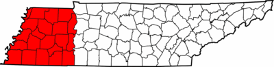
West Tennessee is one of the three Grand Divisions of the state of Tennessee. Of the three, it is the one that is most sharply defined geographically. Its boundaries are the Mississippi River on the west and the Tennessee River on the east. This region's boundaries have been expanded slightly to include all of Hardin County, which is bisected by the Tennessee River. The states of Kentucky and Mississippi provide the respective northern and southern boundaries, with the exception of a portion of Lauderdale County, Alabama, which lies southeast of Hardin County. The region consists of twenty-one counties.
Unlike the geographic divisions of most American states, the term West Tennessee has a legal as well as a socio-economic meaning. West Tennessee, Middle Tennessee, and East Tennessee are Tennessee's three Grand Divisions. According to the State Constitution, no more than two of the Tennessee Supreme Court's five Justices can be residents of any one Grand Division and the Supreme Court rotates meeting in courthouses in each of the three divisions. The Supreme Court building for West Tennessee is in Jackson, Tennessee. Similar rules apply to certain other state commissions and boards, as well, to prevent them from showing any geographical biases.
West Tennessee is by slight amounts less populous and smaller in land area than the other two Grand Divisions. At the time of the 2000 U.S. Census, West Tennessee had 1,499,802 inhabitants living in its 21 counties, and these have a combined land area of approx. 27,582 km² (10,650 square mi). West Tennessee's population was about 26.4 percent of the state's total, and its land area is about 25.8 percent of the state's land area. West Tennessee's population density was about 140 persons per square mile (54.4 persons per square kilometer) at the time of the 2000 United States Census. Of the nearly 1.5 million persons living in West Tennessee at the time of the 2000 Census, approximately 650,000 of those lived in Memphis, or about 43.3% of the grand division's population.
History
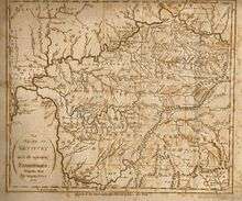
While the region of Tennessee west of the Tennessee River was, on paper, part of Tennessee at its statehood in 1796, it had been recognized as Chickasaw territory by the 1786 Treaty of Hopewell, and it did not come under actual American control until it was obtained in a series of cessions by the Chickasaw in 1818, an acquisition known as the Jackson Purchase, and named for Andrew Jackson, one of the officials involved. The purchase also included the westernmost area of Kentucky as well as a part of northern Mississippi. Although the vast majority of the purchases lie in Tennessee, the term "Jackson Purchase" is used today mostly to refer solely to the Kentuckian portion of the acquisition. This term is also somewhat misleading. Jackson, a military officer at the time, was one of several federal treaty commissioners. He did not personally negotiate the whole land cession, nor was it done in a single treaty.
Geography
West Tennessee is located within the Mississippi Embayment, part of the Gulf Coastal Plain. Because of this, the terrain is flatter than the eastern parts of the state. Areas right along the Mississippi River are located within the alluvial floodplain. However, much of the western counties of the region are protected from flooding by the Chickasaw Bluffs, ridges of loess rising 50–200 feet above the floodplain. Although the land is lower and flatter than Middle and East Tennessee, some hilly terrain exists, especially along the bluffs bordering the Mississippi River and the land bordering the Tennessee River (known as the West Tennessee Highlands). Hilly land in these areas is forested. Otherwise, most of the land in West Tennessee is used as farmland. The soil in this part of the state comes from when a prehistoric sea dried up and left sediment in its place. Unlike in the rest of the state, bedrock is buried a few thousand feet below the surface.
Hydrology
Several rivers and streams, besides the Mississippi and Tennessee, exist in West Tennessee. All of them were originally slowly moving swamps or low-gradient meandering streams before nearly all of them were channelized in the 20th century. Rivers that empty into the Mississippi River include the Obion River, Forked Deer River, Hatchie River (which has not been channelized), Loosahatchie River, Wolf River, and Nonconnah Creek. Rivers that empty into the Tennessee River include the Big Sandy River and Beech River.
Aquifer
West Tennessee sits on top of an artesian aquifer. This aquifer is the main source of water for Memphis and Shelby County, as well as many other communities. In the Memphis area and areas along the bluffs, the loess and gravel serves as a cap over the sand making up the aquifer. The rest of West Tennessee serves as a recharge area for the aquifer. This aquifer provides some of the cleanest water in the United States.
Earthquake risk
The entire West Tennessee region, especially the area closest to the Mississippi River, lies in a zone of fairly high estimated risk for earthquakes. This area is at the edge of the New Madrid Seismic Zone. In 1811 and 1812, three of the largest quakes in American history hit this region back when it had few European settlers. By some reports, the earthquakes briefly reversed the flow of the Mississippi River.[1] A lasting legacy of the earthquakes is the Reelfoot Lake, a large but shallow body of water in northwestern Tennessee that was created by the earthquakes.
Counties
There are 21 counties in West Tennessee:
Cities
- Cities and towns with 10,000+ population (2010 Census)[2]
Seven of the thirteen cities in West Tennessee with a population greater than 10,000 are located within Shelby County, which comprises Memphis and its six suburbs.
- Memphis (662,897)
- Jackson (65,211)
- Bartlett (54,613)
- Collierville (43,965)
- Germantown (38,844)
- Dyersburg (17,145)
- Lakeland (12,430)
- Arlington (11,517)
- Martin (11,473)
- Union City (10,895)
- Brownsville (10,292)
- Millington (10,176)
- Paris (10,156)
Demographics
West Tennessee is by slight amounts less populous and smaller in land area than the other two Grand Divisions. At the time of the 2000 U.S. Census West Tennessee had 1,499,802 inhabitants living in its 21 counties, and these have a combined land area of approx. 27,582 km² (10,650 square mi). West Tennessee's population was about 26.4 percent of the state's total, and its land area is about 25.8 percent of the state's land area. West Tennessee's population density was about 140 persons per square mile (54.4 persons per square kilometer) at the time of the 2000 United States Census.
African Americans constitute a much larger fraction of the population in West Tennessee than in Middle and East Tennessee. According to the 2010 U.S. census the twenty one counties that make up West Tennessee had a total population of 1,562,220 of which 621,001 were of full or partial African American descent. This means African Americans account for roughly 40% of West Tennessee's population. 57.6% of all Tennessee blacks live in West Tennessee; and the twelve counties in Tennessee whose black percentages are higher than the state average, nine are in West Tennessee. Culturally West Tennessee has much more in common with the Deep South than it does the rest of Tennessee.
West Tennessee registered a population growth rate significantly below the state and national average (11.5% and 9.7% respectively) from 2000 to 2010, significantly less than that of Middle and East Tennessee (18.0% and 10.4%). West Tennessee's population grew only 4.2 percent during the 10-year period; predominantly black Haywood County was the most rapidly diminishing county in the state, losing 5.1% of its population. Only three counties (Chester, Fayette, and Tipton, all increasingly playing a role as bedroom suburbs of metropolitan areas) recorded a growth rate of more than 10 percent from 2000 to 2010. Many West Tennessee counties are not on the state's major transportation routes (railroads or highways) and have no air transport to speak of; and rely heavily on agriculture. With fewer farms and farmers, and the continuing decline of manufacturing, economic opportunities diminish in these counties, and young residents look outside the area for jobs, leading to substantial out-migration. Thus, the population in West Tennessee is increasingly older, with median ages above the state average in most counties; and the over-65 age group constitutes a larger percentage of the total population than the state average, leading in turn to a below-replacement-rate birth/death ratio, and economic decline, including empty and neglected housing and business structures.[3]
Congressional Districts
West Tennessee is represented by part of the 7th district, and all of the 8th and 9th districts. The 7th district covers Benton, Decatur, Henderson, Hardeman, Chester, McNairy, and Hardin counties. The 8th district represents the remaining counties except for Memphis and Millington, which are represented by the 9th district.
Area codes
Until the year 2001, West Tennessee, including all of Hardin County, was in the area code 901. After a large amount of population growth necessitated two area codes for West Tennessee, Memphis, its northern and eastern suburbs, as well as Fayette and Tipton counties, retained the 901 area code, with the remainder of West Tennessee being placed into area code 731. The Memphis area is one of the largest metropolitan areas that does not require 10-digit dialing, and it is anticipated it will remain this way for many years to come.
Transportation
Roads and highways
West Tennessee currently has four interstate highways running through it. The longest one is Interstate 40, which runs for 134 miles (216 km) from the Mississippi River in Memphis, passes south of Brownsville, north of Jackson, and crosses the Tennessee River in Benton County. Interstate 240 is a bypass route of I-40 and runs to the south of Memphis. Interstate 55 runs for 13 miles (21 km) from the Mississippi state line to the Mississippi River, all of which are within southwest Memphis. Interstate 155 is located in the northwestern part of West Tennessee. It runs from the Mississippi River to Dyersburg. Two future interstates are to travel in West Tennessee: Interstate 69 and Interstate 22. I-69 will go from South Fulton and pass through Union City, Dyersburg, Ripley, Covington, Millington, and Memphis. Interstate 269 will serve as an outer beltway for Memphis running to the east of it. I-22 will come from Mississippi to connect with I-240.
The U.S. Highways that travel through West Tennessee are:
- U.S. Route 45
- U.S. Route 51
- U.S. Route 61
- U.S. Route 64
- U.S. Route 70
- U.S. Route 72
- U.S. Route 78
- U.S. Route 79
- U.S. Route 412
- U.S. Route 641
Rail transport
Freight railways crisscross West Tennessee. Norfolk Southern maintains a line running through the southern counties from Memphis to the shoals area of Alabama. They also maintain a line which runs from South Fulton through Martin, Milan, Jackson, and Selmer crossing into Mississippi. Canadian National runs a line from South Fulton, through Union City, Dyersburg and Memphis. From here the line splits into two: one runs through the Mississippi Delta and the other one runs through the center of Mississippi. BNSF runs through Memphis from Mississippi to downtown Memphis, crossing the River on the Frisco Bridge. Union Pacific maintains a short line through Memphis crossing the river on the Harahan Bridge and connects with other lines in the area. CSX runs a line from Memphis through Memphis, Brownsville, Humboldt, Milan, McKenzie, and Camden, then crossing the Tennessee River. Many other short line railroads exist scattered throughout the region.
There are three intermodal facilities around the Memphis area. One is operated by Norfolk Southern in Rossville, one operated by BNSF in Southeast Memphis, and one operated by Canadian National in Southwest Memphis.
Amtrak runs the City of New Orleans passenger rail service along the CN rail line. There are two stops in West Tennessee along this route, which are in Downtown Memphis at Central Station and in Newbern north of Dyersburg.
Airports
West Tennessee has one international airport, Memphis International Airport. This is the largest freight airport in the United States and the second largest in the world. Two regional airports exist: McKellar-Sipes Regional Airport is located outside of Jackson and Dyersburg Regional Airport southwest of Dyersburg. In addition to these, several general aviation exist along with two former military airstrips. Arnold Field in Lauderdale County maintains an airstrip and Millington Regional Jetport serves as a backup landing strip for FedEx.
Universities and colleges
The public universities and colleges in West Tennessee are the University of Memphis, the University of Tennessee at Martin, Dyersburg State Community College, Jackson State Community College, Southwest Tennessee Community College, and the University of Tennessee Health Science Center in Memphis, which has state medical, dental, nursing, and pharmacy schools, as well as a graduate program in health sciences. The University of Memphis has a branch campus in Jackson after taking over the former Lambuth University campus.
Private institutions of higher education located in the region include Christian Brothers University, LeMoyne–Owen College, and Rhodes College in Memphis. Jackson is the home of Union University and Lane College. A few other private institutions of higher education lie in other areas of West Tennessee, such as Bethel University and Freed-Hardeman University.
References
- ↑ Feldman, Jay. When the Mississippi Ran Backwards : Empire, Intrigue, Murder, and the New Madrid Earthquakes New York: Free Press, 2005. ISBN 978-0-7432-4278-3
- ↑ U.S. Census Bureau State & County QuickFacts http://quickfacts.census.gov/qfd/states/47/4775940.html
- ↑ Moser, H. Ronald and John, Horace E. "Tennessee Population Growth 2000-2010" Tennessee Business October 2011