Wilson County, Tennessee
| Wilson County, Tennessee | ||
|---|---|---|
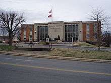 Wilson County Courthouse in Lebanon | ||
| ||
|
Location in the U.S. state of Tennessee | ||
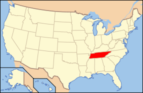 Tennessee's location in the U.S. | ||
| Founded | October 26, 1799 | |
| Seat | Lebanon | |
| Largest city | Mt. Juliet | |
| Area | ||
| • Total | 583 sq mi (1,510 km2) | |
| • Land | 571 sq mi (1,479 km2) | |
| • Water | 12 sq mi (31 km2), 2.1% | |
| Population (est.) | ||
| • (2015) | 128,911 | |
| • Density | 200/sq mi (77/km²) | |
| Congressional district | 6th | |
| Time zone | Central: UTC-6/-5 | |
| Website |
www | |

Wilson County is a county located in the U.S. state of Tennessee. As of the 2010 census, the population was 113,993.[1] Its county seat is Lebanon.[2] The largest city in the county is Mt. Juliet.
Wilson County is part of the Nashville-Davidson–Murfreesboro–Franklin, TN Metropolitan Statistical Area.
History
Wilson County was created in 1799 from a portion of Sumner County, and named for Major David Wilson, a Revolutionary War veteran and statesman.[3] The county remained predominantly agrarian throughout the 19th century. The arrival of the railroad after the Civil War boosted the county's timber sector, and several large factories were constructed in the county during the early 20th century.[3]
Wilson County was the site of an important saltpeter mine. Saltpeter is the main ingredient of gunpowder and was obtained by leaching the earth from Valley Cave. Valley Cave is located near Statesville. Numerous saltpeter hoppers still inside the cave indicate that this was a relatively large mining operation. These saltpeter vats may date from either the War of 1812 mining era or the Civil War mining era, or perhaps both. Further research is needed to determine when this mine was active.[4]
Geography
According to the U.S. Census Bureau, the county has a total area of 583 square miles (1,510 km2), of which 571 square miles (1,480 km2) is land and 12 square miles (31 km2) (2.1%) is water.[5] The Cumberland River flows along the county's northern border with Trousdale and Sumner counties. This section of the river is part of Old Hickory Lake. Several streams in the western part of the county are part of the Stones River basin.
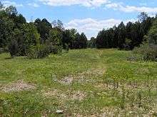
Wilson County is home to a large concentration of cedar glades, a unique ecosystem where the soil is too rocky or shallow for trees to grow. Many of these glades are found in Cedars of Lebanon State Park.
Adjacent counties
- Trousdale County (north)
- Smith County (northeast)
- DeKalb County (east)
- Cannon County (southeast)
- Rutherford County (south)
- Davidson County (west)
- Sumner County (northwest)
State protected areas
- Cedars of Lebanon State Forest
- Cedars of Lebanon State Park
- Couchville Cedar Glade State Natural Area (part)
- Gattinger's Cedar Glade and Barrens State Natural Area (part)
- John and Hester Land Cedar Glades State Natural Area
- Old Hickory Wildlife Management Area (part)
- Percy Priest Wildlife Management Area (part)
- Vesta Cedar Glade State Natural Area
- Vine Cedar Glade State Natural Area
Demographics
| Historical population | |||
|---|---|---|---|
| Census | Pop. | %± | |
| 1800 | 3,261 | — | |
| 1820 | 18,730 | — | |
| 1830 | 25,472 | 36.0% | |
| 1840 | 24,460 | −4.0% | |
| 1850 | 27,443 | 12.2% | |
| 1860 | 26,072 | −5.0% | |
| 1870 | 25,881 | −0.7% | |
| 1880 | 28,747 | 11.1% | |
| 1890 | 27,148 | −5.6% | |
| 1900 | 27,078 | −0.3% | |
| 1910 | 25,394 | −6.2% | |
| 1920 | 26,241 | 3.3% | |
| 1930 | 23,929 | −8.8% | |
| 1940 | 25,267 | 5.6% | |
| 1950 | 26,318 | 4.2% | |
| 1960 | 27,668 | 5.1% | |
| 1970 | 36,999 | 33.7% | |
| 1980 | 56,064 | 51.5% | |
| 1990 | 67,675 | 20.7% | |
| 2000 | 88,809 | 31.2% | |
| 2010 | 113,993 | 28.4% | |
| Est. 2015 | 128,911 | [6] | 13.1% |
| U.S. Decennial Census[7] 1790-1960[8] 1900-1990[9] 1990-2000[10] 2010-2014[1] | |||
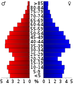
As of the census[12] of 2000, there were 88,809 people, 32,798 households, and 25,582 families residing in the county. The population density was 156 people per square mile (60/km²).
There were 34,921 housing units at an average density of 61 per square mile (24/km²). The racial makeup of the county was 91.50% White, 6.26% Black or African American, 0.32% Native American, 0.48% Asian, 0.03% Pacific Islander, 0.48% from other races, and 0.92% from two or more races. 1.27% of the population were Hispanic or Latino of any race.
There were 32,798 households out of which 37.20% had children under the age of 18 living with them, 64.20% were married couples living together, 10.10% had a female householder with no husband present, and 22.00% were non-families. 18.10% of all households were made up of individuals and 6.10% had someone living alone who was 65 years of age or older. The average household size was 2.67 and the average family size was 3.03.
In the county, the population was spread out with 26.20% under the age of 18, 7.70% from 18 to 24, 31.70% from 25 to 44, 24.70% from 45 to 64, and 9.70% who were 65 years of age or older. The median age was 36 years. For every 100 females there were 97.40 males. For every 100 females age 18 and over, there were 94.80 males.
The median income for a household in the county was $50,140, and the median income for a family was $56,650. Males had a median income of $39,848 versus $26,794 for females. The per capita income for the county was $22,739. About 4.60% of families and 6.70% of the population were below the poverty line, including 7.80% of those under age 18 and 11.50% of those age 65 or over.
In the 2004 U.S. presidential election, 65 percent of voters supported the reelection of President of the United States George W. Bush. In the 2008 U.S. presidential election, 68 percent of voters favored Republican Senator John McCain.
By 2008 the population of Wilson County had risen to nearly 110,000.[13]
By 2014, 330 children were homeless in Wilson County.[14]
Education
Wilson County Schools oversees 22 public schools, including 2 adult education centers and a technical education center. The county has four high schools: Lebanon High School, Wilson Central High School, Watertown High School and Mount Juliet High School.
Cumberland University is located in Lebanon.
Communities
Cities
- Lebanon (county seat)
- Mt. Juliet (largest city)
Town
Unincorporated
- Cainsville
- Carroll
- Cherry Valley
- Couchville
- Doaks Crossroads
- Egan
- Gladeville
- Green Hill
- Hunter's Point
- Hurricane
- LaGuardo
- Leeville
- Martha
- Norene
- Oakland
- Possum Town
- Prosperity
- Rural Hill
- Shop Springs
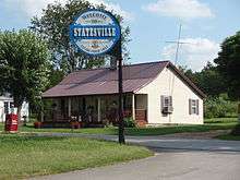
- Statesville
- Suggs Creek
- Tuckers Crossroads
- Vesta
- Vine
Former community
Notable people
- Jordan Anderson, Slave freed during the American Civil War
- Casey Atwood, RNASCAR driver
- Adrian Belew, Rock guitarist and King Crimson member
- Charlie Daniels, country and rock musician
- Dan Evins, founder of the Cracker Barrel restaurants
- Bobby Hamilton, 2004 NASCAR Craftsman Truck Series champion
- Erika Jo, Country music singer, 2005 Nashville Star winner
- Kings of Leon, rock band
- John Roane (1817–1867), 4th Governor of Arkansas; Brigadier-General in the Provisional Army of the Confederate States
- David P. Sartor, Composer and conductor
- Gretchen Wilson, Country musician
- Ross Winn, Anarchist writer and publisher
See also
References
- 1 2 "State & County QuickFacts". United States Census Bureau. Retrieved December 7, 2013.
- ↑ "Find a County". National Association of Counties. Retrieved 2011-06-07.
- 1 2 Frank Burns, "Wilson County," Tennessee Encyclopedia of History and Culture. Retrieved: 24 April 2013.
- ↑ Thomas C. Barr, Jr., "Caves of Tennessee", Bulletin 64 of the Tennessee Division of Geology, 1961, 568 pages.
- ↑ "2010 Census Gazetteer Files". United States Census Bureau. August 22, 2012. Retrieved April 14, 2015.
- ↑ "County Totals Dataset: Population, Population Change and Estimated Components of Population Change: April 1, 2010 to July 1, 2015". Retrieved July 2, 2016.
- ↑ "U.S. Decennial Census". United States Census Bureau. Retrieved April 14, 2015.
- ↑ "Historical Census Browser". University of Virginia Library. Retrieved April 14, 2015.
- ↑ Forstall, Richard L., ed. (March 27, 1995). "Population of Counties by Decennial Census: 1900 to 1990". United States Census Bureau. Retrieved April 14, 2015.
- ↑ "Census 2000 PHC-T-4. Ranking Tables for Counties: 1990 and 2000" (PDF). United States Census Bureau. April 2, 2001. Retrieved April 14, 2015.
- ↑ Based on 2000 census data
- ↑ "American FactFinder". United States Census Bureau. Retrieved 2008-01-31.
- ↑ 2008 Census Population Estimates by County
- ↑ Esh, Connie (November 23, 2014). "Homeless in Wilson County". The Wilson Post. Retrieved August 27, 2016.
Homeless children may live in a tent or a camper, sleep on a different couch every night, sleep in a car or even sleep in a ditch. [...] And in the Wilson County school system, at least 330 children fit that definition.
External links
| Wikimedia Commons has media related to Wilson County, Tennessee. |
- Official site
- Lebanon-Wilson County Chamber of Commerce
- Wilson County Schools
- Wilson County Convention and Visitors Bureau
- Tennessee Central Economic Alliance for Wilson County
- Wilson County at TNGenWeb
- Wilson County at DMOZ
 |
Sumner County | Trousdale County | Smith County | |
| Davidson County | |
DeKalb County | ||
| ||||
| | ||||
| Rutherford County | Cannon County |
Municipalities and communities of Wilson County, Tennessee, United States | ||
|---|---|---|
| Cities | ||
| Town | ||
| CDPs | ||
| Unincorporated communities | ||
| Ghost towns | ||
Coordinates: 36°10′N 86°18′W / 36.16°N 86.30°W