LaFollette, Tennessee
| LaFollette, Tennessee | |
|---|---|
| City | |
|
Buildings along Central Avenue (U.S. Route 25W) | |
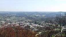
 Location of La Follette, Tennessee | |
| Coordinates: 36°22′30″N 84°7′39″W / 36.37500°N 84.12750°WCoordinates: 36°22′30″N 84°7′39″W / 36.37500°N 84.12750°W | |
| Country | United States |
| State | Tennessee |
| County | Campbell |
| Government | |
| • Mayor | Mike Stanfield |
| • Vice Mayor | Bob Fannon |
| Area | |
| • Total | 4.9 sq mi (12.7 km2) |
| • Land | 4.9 sq mi (12.7 km2) |
| • Water | 0.0 sq mi (0.0 km2) |
| Elevation | 1,073 ft (327 m) |
| Population (2014 est.) | |
| • Total | 7,131[1] |
| • Density | 1,487/sq mi (574.1/km2) |
| Time zone | Eastern (EST) (UTC-5) |
| • Summer (DST) | EDT (UTC-4) |
| ZIP code | 37766 |
| Area code(s) | 423 |
| FIPS code | 47-40180[2] |
| GNIS feature ID | 1652480[3] |
| Website |
www |

LaFollette is a city in Campbell County, Tennessee, United States. Its population was 7,456 at the 2010 census,[4] with an estimated population in 2014 of 7,131.[1] It is the principal city of the LaFollette, Tennessee Micropolitan Statistical Area, which includes all of Campbell County, and is a component of the Knoxville-Sevierville-La Follette Combined Statistical Area. While the city's official spelling is one word ("LaFollette")—after its founders, Harvey Marion LaFollette and his younger brother Grant LaFollette—several federal agencies spell the city's name with two words ("La Follette").
History
Harvey and Grant LaFollette purchased 37,000 acres (150 km2) at Big Creek Gap, where the present community lies, around 1890. They founded the LaFollette Coal, Iron, and Railway Company in order to exploit mineral resources they had observed. Although the business failed during the 1920s, the community continued to grow.[5][6] The city of LaFollette was incorporated in 1897.
Geography
LaFollette is located near the geographic center of Campbell County at 36°22′30″N 84°7′39″W / 36.37500°N 84.12750°W (36.375006, −84.127623).[7] The city is situated in Powell Valley, where the Appalachian Ridge-and-Valley province gives way to the Cumberland Plateau region. Cumberland Mountain, a 50-mile (80 km) ridge stretching from Cumberland Gap in the east to Bruce Gap in the west, rises north of LaFollette. Norris Lake dominates the area to the south. Jacksboro lies adjacent to LaFollette to the southwest. A leg of the Cumberland Trail is accessible off Tennessee Avenue at the north end of LaFollette.
According to the United States Census Bureau, the city has a total area of 4.9 square miles (12.7 km2), all land.[4] The elevation varies around the city, around 1,050 feet (320 m) in the valley areas to 1,500 feet (460 m) on ridge tops. The average elevation is around 1,150 feet (350 m).
U.S. Route 25W and state routes 9 and 63 run concurrently through the community. Interstate 75 is 8 miles (13 km) to the southwest, beyond Jacksboro. Jellico is 23 miles (37 km) to the north via US 25W, over the Cumberland Plateau.
Demographics
| Historical population | |||
|---|---|---|---|
| Census | Pop. | %± | |
| 1900 | 366 | — | |
| 1910 | 2,816 | 669.4% | |
| 1920 | 3,056 | 8.5% | |
| 1930 | 2,637 | −13.7% | |
| 1940 | 4,010 | 52.1% | |
| 1950 | 5,797 | 44.6% | |
| 1960 | 6,204 | 7.0% | |
| 1970 | 6,902 | 11.3% | |
| 1980 | 8,198 | 18.8% | |
| 1990 | 7,192 | −12.3% | |
| 2000 | 7,926 | 10.2% | |
| 2010 | 7,456 | −5.9% | |
| Est. 2015 | 7,053 | [8] | −5.4% |
| Sources:[1][9] | |||
As of the census[2] of 2000, there were 7,926 people, 3,422 households, and 2,135 families residing in the city. The population density was 1,624.7 people per square mile (627.1/km²). There were 3,779 housing units at an average density of 774.6 per square mile (299.0/km²). The racial makeup of the city was 97.89% White, 0.54% African American, 0.40% Native American, 0.18% Asian, 0.08% Pacific Islander, 0.14% from other races, and 0.77% from two or more races. Hispanic or Latino of any race were 0.42% of the population.
There were 3,422 households out of which 26.5% had children under the age of 18 living with them, 39.8% were married couples living together, 17.9% had a female householder with no husband present, and 37.6% were non-families. 34.5% of all households were made up of individuals and 17.5% had someone living alone who was 65 years of age or older. The average household size was 2.24 and the average family size was 2.86.
In the city the population was spread out with 22.0% under the age of 18, 8.7% from 18 to 24, 25.5% from 25 to 44, 22.6% from 45 to 64, and 21.2% who were 65 years of age or older. The median age was 40 years. For every 100 females there were 82.8 males. For every 100 females age 18 and over, there were 78.1 males.
The median income for a household in the city was $18,370, and the median income for a family was $24,235. Males had a median income of $25,541 versus $18,835 for females. The per capita income for the city was $13,355. About 28.3% of families and 33.1% of the population were below the poverty line, including 48.7% of those under age 18 and 21.1% of those age 65 or over.
Notable people
- Adele Arakawa, television news anchor
- Howard "Louie Bluie" Armstrong, musician
- The Isaacs, a southern gospel/bluegrass family singing group
- Carl Stiner, U.S. Army general
- J. Will Taylor, congressman
References
- 1 2 3 "Annual Estimates of the Resident Population: April 1, 2010 to July 1, 2014 (PEPANNRES): Incorporated Places in Tennessee". U.S. Census Bureau, American Factfinder. Retrieved July 2, 2015.
- 1 2 "American FactFinder". United States Census Bureau. Retrieved 2008-01-31.
- ↑ "US Board on Geographic Names". United States Geological Survey. 2007-10-25. Retrieved 2008-01-31.
- 1 2 "Geographic Identifiers: 2010 Census Summary File 1 (G001): La Follette city, Tennessee". U.S. Census Bureau, American Factfinder. Retrieved July 2, 2015.
- ↑ Greg Miller, "Lafollette, Tennessee, A City of Dreams," LaFollette official website, 2007.
- ↑ Jim Matheny, Why do they call it that- LaFollette, WBIR.com, 19 August 2011. Retrieved: 30 August 2011.
- ↑ "US Gazetteer files: 2010, 2000, and 1990". United States Census Bureau. 2011-02-12. Retrieved 2011-04-23.
- ↑ "Annual Estimates of the Resident Population for Incorporated Places: April 1, 2010 to July 1, 2015". Retrieved July 2, 2016.
- ↑ "Census of Population and Housing: Decennial Censuses". United States Census Bureau. Retrieved 2012-03-04.
External links
| Wikimedia Commons has media related to LaFollette, Tennessee. |
- Official website
- Municipal Technical Advisory Service entry for LaFollette — information on local government, elections, and link to charter
- LaFollette Press newspaper
- An essay on local radio in La Follette in the 1950s and 1960s, including original audio: Hanson, Bradley, "The Tennessee Jamboree: Local Radio, the Barn Dance, and Cultural Life in Appalachian East Tennessee," Southern Spaces, November 20, 2008.
Municipalities and communities of Campbell County, Tennessee, United States | ||
|---|---|---|
| Cities | ||
| Towns | ||
| CDP | ||
| Unincorporated communities | ||
| Footnotes | ‡ This populated place also has portions in an adjacent county or counties | |
| Principal City |   | |
|---|---|---|
| Other Cities | ||
| Counties | ||