Tirupattur taluk
%2C_Tirupattur%2C_Vellore_Dt%2C_Tamil_Nadu.jpg)
| Tirupattur திருப் பத்தூ ர் | |
|---|---|
| Big town | |
| Nickname(s): Sandana Nagaram | |
 Tirupattur Location in Tamil Nadu, India | |
| Coordinates: 12°30′N 78°36′E / 12.50°N 78.60°ECoordinates: 12°30′N 78°36′E / 12.50°N 78.60°E | |
| Country |
|
| State | Tamil Nadu |
| District | Vellore |
| Government | |
| • Chairman | MR.Arasu |
| Elevation | 387 m (1,270 ft) |
| Population (2011) | |
| • Total | 63,798 |
| Languages | |
| • Official | Tamil |
| Time zone | IST (UTC+5:30) |
| PIN | 635601, 635602 |
| Telephone code | 04179 |
| Vehicle registration | TN-83 |
| Nearest city | Vellore (90 km), Salem (108 km) & Bangalore (130 km) |
| Sex ratio | 993 ♂/♀ |
| Lok Sabha constituency | Thiruvannamalai |
| Vidhan Sabha constituency | Tirupattur |
| Website | Tirupattur |
Tirupattur taluk is a taluk in Vellore district of the Indian state of Tamil Nadu. The headquarters of the taluk is the town of Tirupattur. This fastest developing town is also known as "SANDALWOOD CITY" known for its rich and pure Sandalwoods.
Population
In the 2001 Indian census, the taluk of Tirupattur had a population of 50,455 with 23,656 males and 22,799 females. There were 973 women for every 1000 men. The taluk had a literacy rate of 66.07. The total number of households was 111,192.[1]
In the 2011 census Tirupattur taluk had a population of 567,396.[2]
Tiruppattur is a town located in Vellore District, India, which is one of the oldest towns in Tamil Nadu. It is located approximately 40 km from Krishnagiri, 85 km from Hosur, 85 km from thiruvannamalai and 125 km from Bangalore. The town has mainly small-scale industries and mills. It is an important commercial center from time immemorial (whereas Vaniyambadi and Ambur, which were once smaller towns, have recently flourished). It was a revenue subdivision during British raj and remains so. It has Old Shiva, Vishnu temples and Tanks (Big Tank & Small Tank) built during the Hoysala Dynasty. It is well connected by road and rail to other important cities of Tamil Nadu such as Thiruvannamalai, Chennai, Salem, Coimbatore and Vellore and to Bangalore in Karnataka. This town is also famous in Islamic religious circles as many great saints "Awliyas" had made it their home town. Some of them are buried at various places in the town, including Hazrath Syed Sha Mohammed alias Syed Khawja Meeran Hussaini Jaffari, Hazrath Syed ShaAmeenuddin Hussaini Chisty ur Kahdri (who is better known as Munshi Hazrath); he was the last among a series of saints who have lived and have been buried at Tirupattur.
The name Tirupattur means a group of ten villages/small towns. There exists a village called Aathiyur (Aathi means Begin) in the southern fringes of the Town and Kodiyur (Kodi means End) in the northern fringes of the town. It is surrounded by several of these villages, making Tirupattur a Taluk. Tirupattur's population and land area are good enough to have political representations in the state legislature of Tamil Nadu (Member of the Legislative Assembly), and part of Thiruvannamalai constituency for the central/federal legislature of India (Member of Parliament as of 2009 elections). Tirupattur Municipality Tirupattur Municipality was constituted as a third grade municipality in the year 1886. As per G.O. No. 194, date: 10.02.1970, classified as Second Grade Municipality. At present from 1.4.1977 onwards as per G.O. No. 654, classified as first grade municipality.
Demographics
In the 2001 Indian census, Tirupathur had a population of 60,803. Males constituted 51% of the population and females 49%. Tirupathur had an average literacy rate of 73%, significantly higher than the national average of 59.5%: male literacy was 79%, and female literacy was 67%. In 2001 in Tirupathur, 11% of the population was under 6 years of age.[1]
In the 2011 census, the city of Tirupathur had a population of 63,798.[3] Males constituted 51% of the population and females 49%. Tirupathur had an average literacy rate of 78%, significantly higher than the national average of 59.5%: male literacy was 80%, and female literacy was 76%. In 2011 in Tirupathur, 11% of the population was under 6 years of age.
Geography
It is known as the "Sandalwood Town" due to the abundant availability of sandalwood trees in the surrounding hills.It is very close to the 4th major hill station of Tamil Nadu, the Yelagiri hills, which is also known as the common man's Ooty. The town is at an average elevation of 388 m.
History
A long time ago Tirupattur had been known as Thasaranyam, and was famous for ten large forests in and around Tirupattur and for its Rich Sandalwood. Various famous people visited this place including Adi Sankara.Even from the olden days this town is highly valued due to its purest form of sandalwood and the people of Tirupattur is known for their hard work and excellency in work.
Economy
This area is very famous for sandalwood. It claims to be the second biggest depot in Asia. The main businesses is goldsmithing and selling raw products.
Location of Tirupattur
The strategic location of this town is such that the town acts as an "urban magnet" to radius of 20 to 25 km all-round. Nearly 200 villages are mainly depending on this town for all their urban needs. The growth is dominated by wholesale agriculture production and Sandalwood. The Urban Municipal town spreads over an extent of 9.26sq.km this is a class-I town in Vellore District is based on population range floating population is increasing day by day.
Infrastructure
The Tirupattur town has 56.059 km length of roads and the municipality is maintaining ‘B’ Grade Bus stand in the heart of the town. There is a century old municipal market having 413 shops which helps in promoting commercial and economic activities of the town.
Climate
This town is known for recording coldest temperature in the Tamil Nadu plains during winter. The seasonal climate conditions are moderate and the weather is uniformly salubrious. The town experiences hot summers and cool winters.
The town gets its majority of rainfall during the south west monsoon period. September and October are the wettest months with around 400 mm of rain being received in these two months. The town also experiences fairly frequent thunderstorms in late April and May, which gives necessary relief from the heat, along with the dip in night temperatures. The warmest nights are in May, when the town has an average minimum temperature of 23.4 °C. The coldest nights are in January, when the average minimum temperatures drop to 16.1 °C. May is the hottest month with an average maximum of 37.0 °C.
The highest ever temperature recorded in the town is 46.3 °C on 7 May 1976. The lowest ever recorded temperature is 10.2 °C on 15 December 1974. The highest 24‑hour precipitation is 167.3mm received on 4 November 1966. The average annual rainfall being received in the town is 982 mm.
| Climate data for Tirupattur (1951-2012) | |||||||||||||
|---|---|---|---|---|---|---|---|---|---|---|---|---|---|
| Month | Jan | Feb | Mar | Apr | May | Jun | Jul | Aug | Sep | Oct | Nov | Dec | Year |
| Record high °C (°F) | 35.6 (96.1) |
39.4 (102.9) |
41.2 (106.2) |
45.8 (114.4) |
46.3 (115.3) |
41.8 (107.2) |
39.6 (103.3) |
39.3 (102.7) |
40.0 (104) |
37.1 (98.8) |
36.3 (97.3) |
34.3 (93.7) |
46.3 (115.3) |
| Average high °C (°F) | 29.6 (85.3) |
32.3 (90.1) |
34.9 (94.8) |
36.3 (97.3) |
37.0 (98.6) |
34.8 (94.6) |
33.2 (91.8) |
33.4 (92.1) |
32.9 (91.2) |
31.5 (88.7) |
29.9 (85.8) |
29.0 (84.2) |
32.9 (91.21) |
| Average low °C (°F) | 16.1 (61) |
18.3 (64.9) |
20.4 (68.7) |
22.6 (72.7) |
23.4 (74.1) |
23.1 (73.6) |
22.9 (73.2) |
22.9 (73.2) |
22.6 (72.7) |
21.9 (71.4) |
19.8 (67.6) |
17.2 (63) |
20.93 (69.68) |
| Record low °C (°F) | 10.3 (50.5) |
10.5 (50.9) |
12.8 (55) |
16.6 (61.9) |
18.3 (64.9) |
19.1 (66.4) |
18.4 (65.1) |
17.0 (62.6) |
14.6 (58.3) |
15.5 (59.9) |
12.1 (53.8) |
10.2 (50.4) |
10.2 (50.4) |
| Average precipitation mm (inches) | 1.3 (0.051) |
4.3 (0.169) |
8.3 (0.327) |
22.0 (0.866) |
103.8 (4.087) |
58.5 (2.303) |
124.3 (4.894) |
132.4 (5.213) |
192.5 (7.579) |
190.2 (7.488) |
101.8 (4.008) |
42.1 (1.657) |
981.5 (38.642) |
| Average precipitation days | 0.1 | 0.3 | 0.5 | 1.6 | 5.0 | 3.1 | 5.5 | 5.6 | 7.9 | 8.0 | 4.7 | 1.7 | 44 |
| Source: India Meteorological Department,[4] | |||||||||||||
Nature of Soil The major group of soils that are found in the town are black and red varieties. The red soil constitutes 90 percent while black soil only 10 percent.
Historical Moments
Tirupattur is called as the "Sandal City", "Sandal Kingdom", Even a rough estimation cannot easily be established on the origin of Tirupattur town, owing to its antiquity.
Tirupattur has a unique name for its own to have the "FIRST COLLECTOR OFFICE" in India. And this Collector office is currently serving the nation as the Tirupattur railway Junction.
Through, the inscriptions, so far surveyed by Archaeological Survey of India in Tirupattur, it is estimated that this town is more than 1600 years old. During the regimes of various rulers like Cholas, Vijaya Nagara Dynasty, Hoysalas the town had been referred to, by the following names :
Sri Mathava Chaturvedi Mangalam,Veera Narayana Chaturvedi Mangalam, Tiruperur and Brahmapuram (Brahmeeswaram). The present name "Tirupattur" might have got derived from "Tiruperur". Erstwhile "Tiruperur" or "Sri Madhava Chaturvedi Mangalam" was in "Eyyil Nadu", subdivision of "Nigarili Chola Mandalam", division of "Chola Empire".
There existed a fort in the eastern part of the town around 800 years ago. Its entrance might have been near the Kottai Darwaja Sri Veera Anjaneyar Temple, since the word "Kottai" in Tamil means "Fort", and the word "Darwaja" in Hindi/Urdu means "Gate" or "Door". The area is still known as "Kottai"(fort).
The Town was ruled by Cholas, Pallavas, Hoysalas, Vijaya Nagara rulers, Vallala Maharajan, Sambuvarayars, Tipu, Nawabs of Arcot and undoubtedly by the British.
Places to visit
 A view from yelagiri
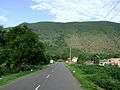 Yelagiri hill
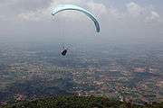 Paragliding in Yelagiri
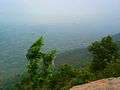 A view from yelagiri
- Yelagiri Hills(27 km from Tirupattur)
Yelagiri is a hill-station on the Vaniyambadi-Tirupattur Road, midway between Chennai and Bangalore. Located at an altitude of 1,050 metres (3,500 ft) and spread across 30 km2, the Yelagiri village (also spelt Elagiri at times) is surrounded by orchards, rose-gardens, and green valleys.
- Vainu Bappu Observatory (37 km from Tirupattur - The largest telescope in Asia.)
- Sri vetkaaliamman temple(142 feet height)(13 km)kandhili
- Jalagamparai Falls (14 km from Tirupattur)
Jalagamparai waterfalls is found on the eastern slope of the Yelagiri hills. It is around 14 km from Tirupattur.
- Javadi Hills(35 km from Tiurpattur)
- Bheeman Falls(38 km from Tirupattur)located over jamunamathur hills.
The Javadi Hills are located about 35 km from Tirupattur. The "Sevan Falls" lies near by. In the middle of this hill, lies the Kavalur Observatory, which has several optical and reflective telescopes run and governed by the Indian Institute of Astrophysics.
Temples to visit
There are several temples to be visited in this ancient town,
- Natham,Jurahara Eswarar(siva) Temple(very olg aged temple built by chola king located at thulanathi River)
"Kottai Eeswaran" temple is the largest temple in Tirupattur and it is believed to have an underground passage which connects to the Vellore Fort.It is approximately 1000-year-old temple. Historical event occurred in this temple that ADHI SANKARAR visited to this temple and presented SRI SAKARA plates, Currently its placed in amman sanidhi. Every month Full Moon pooja and Pradhosa pooja's happening.
- C K Ashram(Place for PEACE)
- Gajendra Varadharaja perumal Temple
- Kamatchiamman/kaliamman Temple.
- Sri Renuga Parameshwari Temple(Chinnakulam Mariamman Temple), This temple is in the bank of a Pond. This is a historical pond.It is 800 years old.The Temple is 1000 years old. Adi Mariamman Thiruvizha is a great festival for the devotees of this temple. Navarathiri, Fullmoon day of Ipasi, First Friday of every month,108 Sangu Pooja special arathanas were conducted.
- Sri SANKARA NILAYAM Temple
- Sri Sakthi Saibaba Temple.
- Dhandapani Temple. Panguni Uthiram is the most famous festival in this temple. People use to carry 'Paal kaavadis' on this day and special poojas are conducted on Thaipoosam. Soora Samharam is also a famous event conducted every year.[5]
•' ChristhuKula Ashram where everymonth Prayers and spiritual meetings happen quiet often by several renowned people like Mohan C Lazarus, Sam Appadhurai, etc.'
- Kannanoor mariyamman temple, at Dharmaraja Kovil street, goddess amman the main deity here, has been exploring its specialty for special alankara (dressing of variour avatars of goddess) every Fridays, such that over 3 turns of 108 weeks has been with successful poojas. peoples from all over town and villages come and get involved in spiritual activities especially every Fridays. 1000-1200 peoples do visit every weeks.
- Sri Shiva Subramani Swamy Temple Located In Adhiyur Village.This is famous Temple In Tirupattur Area and Adhiyur.This Temple Thaipoosam Festival is conducted in Every year.
- Rettai Vinayagar temple, at venugopalswamy kovil street. God vinayagar is found here as two. And also lord krishna here called in the name of "venugopalswamy". The lord vinayaga has appearing two and lord krishna has in the same place in this temple only.
Places of worship
Church
Mary Help of Christians - Parish,
CSI Christ Church,
Sacred Heart College Church,
Don Bosco School Church,
Mary Immaculate School Church,
Koviloor church-pudukottai,
Immanuel Church (Immanuel Gospel Mission),
The Pentecostal Mission Church,
Indian Evangelical Lutheran Church.
Christhukula Ashram(Place for PEACE)
Mosque/ Arabic: Masjid مسجد/ தமிழ்: பள்ளிவாசல்
Muslims perform regular & periodic prayers in Masjids
Aqsa Masjid/Fort Idga Mosque, Makkah Masjid, Gol Gumbaz Dargah Masjid, Jamiah Masjid, Tawakkal Masjid, Qusray Ilahi (Qazi) Masjid, Qilah Masjid/ Fort Mosque, Poorah Masjid, Bilal Masjid, Madina Masjid, Abu bakker Masjid, Umar Farooque Masjid, Noor Masjid, Ijtimah Masjid, Market Masjid, Nayi Gali Masjid
Temples Jurahara Eswarar Temple@Natham Hindu Temples: pudukottai Mariamman Temple, Jalagamparai water fall's Murugan Temple, Varadharaja Perumal Koil, Dhandapani Koil, Kumarasamy Koil, Kottai Bhrameswaran Koil, Kottai Darwaja Anjaneyar Koil, Dharmaraja Koil, Kaliyamman Koil, Muthumariamman Koil, Renuga Parameswari (Chinna Kulam Mariamman koil), Karu mariammam Koil, Tirupathi Gangaiamman Koil, Angamuthumariamman Koil, Gateoor Mariammam Koil, Adhiyur Sri ShivaSubramani Swami Temple, Police line (Muthumariamman) Koil vallalar Nagar Nava Shakthi Mariamman Temple Ezharuvi Murugam Koil and Water Falls
Map routes
 |
Natrampalli | Vaniyambadi, Pallikonda, Vellore | Yelagiri, Alangayam | |
| Krishnagiri | |
Thiruvannamalai | ||
| ||||
| | ||||
| Dharmapuri | Harur, Salem | Singarapettai |
Roadways
The Tamil Nadu state Bus transport corporation (TNSTC) is providing 85% of transport facilities to this town. Tirupattur is well connected by road and rail to major cities of India. Regarding transportation linkage, the highway (NH 46) from Chennai to Krishnagiri (via) Natrampalli passes through the outskirts of the town. The town is separated by a distance with Chennai (225 km), Bangalore (130 km), Vellore (87 km) and Salem (108 km). Several State Highways connects the town from Dharmapuri (60 km), Krishnagiri (40 km) Vaniyambadi (22 km) and Salem (108 km) section. TNSTC also operates luxury volvo A/C buses (Route no:502B) to Chennai daily. Frequent buses are there to Chennai, Vellore, Salem, Bangalore, Villupuram.
A/C Volvo Bus Timings:
From Tirupattur to Chennai
5:00 AM
11:00 AM
6:00 PM
10:00 PM
From Chennai to Tirupattur
6:30 AM
12:30 PM
4:15 PM
11:00 PM
Railways
Tirupattur Railway Station is under the administrative control of the Southern Railways.It is 2 km away from bus stand. Traveling north, Jolarpettai Junction (8 km) is the nearest junction and going south-west, Samalpatti is the next station.Due to proximity to the Jolarpet Railway Junction only few express trains halt here.
The Yelagiri express runs from Tirupattur to Chennai every day.
The Westcoast express (Mangalore-Chennai Central-Manglore) stops at Tiruppattur Railway Station every day. The Other trains that stop at tirupattur station are:
- Yelagiri - Chennai Mail Express - Daily
- Yercaud Express - Daily
- Bangalore-kanyakumari Express -Daily
- Westcoast Express -Daily
- Dhanbad -Allepey Express -Daily
- Erode - jolarpettai Passenger
- Katpadi- Salem Passenger
- Nagercoil -Chennai central Express-only Monday
- Nagercoil-Mumbai CST Express - except Thursday,Saturday, Sunday
- Ernakulam junction-Yeshwantpur Express - only Tuesday
- Ernakulam junction-Bangalore superfast Express - only Monday and Wednesday
- Trivandrum central- Bangalore City junction Express - only on Thursday
- Trivandrum central- Mumbai CST Express - only Saturday
- Coimbatore- Rajkot Express - only Friday
- Trivandrum central- Bangalore City junction Super fast Express - only Sunday
Air
The nearest airports:
Domestic:
- Salem(105 km)
- Vellore Air Strip(85 km)
International:
- Bengaluru (135 km)
- Chennai (225 km)
Schools
CBSE Schools
- Green Valley Public School
- Shri Nandanam International Residential School
- T.K.Raja International School
- Don Bosco School of Excellence
- Shri Ramesh CBSE international school
Elementary Schools
- Our Lady's School.
- Vivekananda Aided Elementary School
- TMS Aided Elementary School
- Government Garden Aided Elementary School
Higher Secondary Schools
- DON BOSCO Matriculation Higher Secondary School
- Dominic Savio Higher Secondary School
- Mary Immaculate Higher Secondary School
- Our Lady's Nursery and Primary School
- C.S.I Girls Matriculation Higher Secondary School
- YMCA Brown Matriculation Higher Secondary School
- Holy Cross Matriculation Higher Secondary School
- Ramakrishna Higher Sccondary School
- Shri Amrita Higher Secondary School
- Ubaibas Girls Higher Secondary School
- TMS Higher Secondary School
- Good Will Matriculation Higher Secondary School
- I.V.N Govt Higher Secondary School
- St. Charles Matriculation Higher Secondary School
- Lions Matriculation Higher Secondary School
- Al Ameen Matriculation Higher Secondary School
- Osmania Higher Secondary School
- Meenakshi Government Girls Higher Secondary School
- Government Boys Higher Secondary School
- Government Garden High School
- RamaKrishna Vidhyalaya Matriculation Higher Secondary School
- Vijayashanthi Vidyalaya Matriculation Higher Secondary School
- Lingannamani Matriculation Higher Secondary School
- Dewan Mohammed Memorial Matriculation Higher Secondary School
- Pudupet Higher Secondary School
Colleges
Arts College
- Tirupattur Arts and Science College
- T.K Raja Arts and Science College
- Sacred Heart College
(A Don Bosco Institution) http://www.shctpt.edu/
- Marappan Lakshmiammal Arts And Science College
- Holy Cross Arts and Science College for Women
- Government College of Arts and Science
- Vannavil Arts and Science College
- Yelagiri Arts and Science College
B.Ed College
- Amrita College of Education
- Amritalaya College of Education
- Dr. David Raja and Dr.Chandraleka College of Education
- G.P. Secondary Teacher Education Training College
- Sri Kalaimagal College of Education
- St. Joseph Women's College of Education
- T.K. Raja College of Education
- Thirumal College of Education
- TES Teacher Training Institute
Polytechnic
- Pandian Polytechnic College
- G.P Polytechnic College
- Sri Nandhanam Polytechnic College
- Sri Padmam Polytechnic College
- Tirupattur Polytechnic College
- Kamaraj Polytechnic College
- Government Polytechnic College
Engineering
- Sri Nandhanam College of Engineering & Technology
- Sri Nandhanam Maritime Academy
- Podhygai College of Engineering & Technology
- Bharathidasan Engineering college
Teacher Training Institutes
- Mary Immaculate Teacher Training Institute
- Amritalaya Teacher Training Institute
- Shri Amrita Teacher Training Institute
- Tirupattur Teacher Training Institute
- G.Ponnusamy Teacher Training Institute
- Sri Padmam Teacher Training Institute
- TES Teacher Training Institute, Jayapuram
- Dr. David Raja Teacher Training Institute, Vengalapuram
Computer Institutes
- Nirmal Multi-Tech Industries
- Aptech Computer Education
- Bosco Integrated Computing Service
- Anugraha Computer Center
- CRN computer Education
- SRM Infotec
Internet Browsing Centers
- Magi Computers, Pudupet Road, Tirupatur Phone: 8124 342889, Email: magicomputerstpt@gmail.com
- Sathyam Computers, Krishnagiri main road(opp. Sapthagiri Hospital), Tirupattur.
- Grace Net Cafe 04179 224885, 9159 224885
- SysSoft Computers Sakthinagar Tirupattur
- Students Net Park, TNHB, Tirupattur
- CCS MICROTECH computer education,browsing, education consultancy, G.B.Complex OPP,pudupet Road,tirupattur. mob:9500245394
- HASTECH Computers. Cutchery street. Tirupattur
- SakthiSoft Internet, No.60, NVS Building, MadhaLodge 1st Floor, Vaniyambadi Road, Tirupattur.
- KCG Net Park, Opp.New Cinema Theatre, Ponniyamman Koil St, Tirupattur
- Global Internet
- Globus
- Dharani
- Friends Net cafe
Nursing College
- jeya nursing college
Politics
Tirupattur assembly constituency is part of Tiruvannamalai (Lok Sabha constituency).[6]
Municipal Chairman S Arasu M.A,M.Ed
References
- 1 2 "Census of India 2001: Data from the 2001 Census, including cities, villages and towns (Provisional)". Census Commission of India. Archived from the original on 2004-06-16. Retrieved 2008-11-01.
- ↑ "NPR Report: Tamil Nadu: Vellore". National Population Register, Ministry of Home Affairs, Government of India. 2011.
- ↑ "NPR Report: Tamil Nadu: Vellore: Tirupathur".
- ↑ "Climatological Information for Tirupattur,India". India Meteorological Department.
- ↑ "Dhandapani Murugan Kovil". Tamilnadu.com. 5 March 2013.
- ↑ "List of Parliamentary and Assembly Constituencies" (PDF). Tamil Nadu. Election Commission of India. Retrieved 2008-10-08.
External links
| State symbols |
|
|---|---|
| Governance |
|
| Topics | |
| Districts |
|
| Major cities | |