Nagercoil
| Nagercoil நாகர்கோவில் നാഗർകോവിൽ | |
|---|---|
| Municipality | |
 Nagercoil kanyakumari | |
| Coordinates: 8°10′N 77°26′E / 8.17°N 77.43°ECoordinates: 8°10′N 77°26′E / 8.17°N 77.43°E | |
| Country |
|
| State | Tamil Nadu |
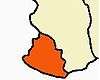
| District | Kanyakumari |
| Government | |
| • Type | Special Grade Municipality |
| • Body | Nagercoil Municipality |
| • Municipal Council | Meena Dev |
| Area | |
| • Total | 49.371 km2 (19.062 sq mi) |
| Elevation | 40 m (130 ft) |
| Population (2011) | |
| • Total | 224,849 |
| • Density | 9,813/km2 (25,420/sq mi) |
| Languages | |
| • Official | Tamil |
| Time zone | IST (UTC+5:30) |
| PIN | 629 xxx |
| Telephone code | 91-4652 & 91-4651 |
| Vehicle registration | TN-74 & TN-75 |
| Literacy | 95.35%[1][2] |
| Website | Official Site |
Nagercoil (Tamil: நாகர்கோவில், Nākarkōyil,Malayalam: നാഗർകോവിൽ, lit. "Temple of the Nāgas") is a town in the southernmost Indian state of Tamil Nadu and a municipality and administrative headquarters of Kanyakumari District. The city is situated close to the tip of the Indian peninsula, locked with the Western Ghats on all sides.[3][4] It was briefly part of the erstwhile Travancore state, till almost a decade after India's Independence from Britain in 1947. In 1956, it was merged with Tamil Nadu. In its earlier days, the town and its surroundings were known as Nanjilnadu. Nagercoil holds a number of educational institutions, hospitals, offices and industries. It is also the hub of industrial and commercial activity in the district, and a fertile agricultural area that produces paddy. The minerals ilmenite and monazite are mined there. The land is surrounded by hills and lush green paddy fields. It is also known for different varieties of bananas. Nagercoil is a land of great traditional and cultural significance.
Etymology
Nagercoil derives its name from a famous old temple called the Nagaraja Temple, Nagercoil (temple of the serpent king) which still exists in the central part of the city. It has been an important temple for Hindus, for centuries and is also a tourist attraction. According to certain accounts, it may once have been a Jain temple as icons of the Tirthankaras Mahavira and Parshvanatha are found on the pillars of the temple.
History
Early history
Nagercoil came under the rule of various kingdoms, notably the Chera, Chola and Pandya kingdoms, at various points in time; historical records reveal that these kingdoms fought over the control of the fertile area of Nanjilnadu and Kottar, a town mentioned in old Tamil writings and maps of ancient India. Archaeological records also show Jain influences in ancient times. Also the literatures reveal the fact that the Nanjil Nadu and Kottar were ruled by Nanjil Valluvan (Sambavars),[5] from Naga tribe with Pandyan origin called Bharathars (Paravar).
Modern history
The modern history of the town is interwoven with the history of Travancore state. The modern town of Nagercoil grew around Kottar, now a locality within the municipal limits. The town came to prominence during and after the reign of Maharaja Marthanda Varma, the king of Travancore, the capital of which was Padmanabhapuram, about 20 km to the north of Nagercoil. The capital was later shifted to Trivandrum, now Thiruvananthapuram, the capital of Kerala state.In the erstwhile Travancore state, Nagercoil was the second most important town in the state, after the capital Trivandrum.His successors continued the reforms he instituted. Although Travancore was considered by many to be a "Hindu" administration, the rulers generally showed religious tolerance, and were not hostile to European aeducators, missionaries and traders. Until the 19th century, the coffers of Travancore were greatly helped by revenues from the trade of pepper and other spices, with the European powers.Irrigation systems (an excellent system is still found around Nagercoil), dams, roads, schools etc. developed under the able administration of the Travancore regents and their Dewan. The British in India considered Travancore a "model native state". At the time, Travancore was the most socially developed, and one of the most economically developed, states under the British Raj. During the British Raj, Travancore was essentially a vassal-state to the British, but the British never interfered in the general administration of the state.
At the time of India's independence from Britain, the then Dewan of Travancore, Sir C. P. Ramaswami Iyer, preferred Travancore to be a sovereign country, but eventually gave up after a tough stand by Sardar Vallabhbhai Patel, India's federal minister in charge of home affairs, as also the Indian National Congress. The late Sir C. P. Ramaswami Iyer is still held in high esteem in Nagercoil, for the many developmental projects he undertook in the then South Travancore, of which the town was a part. After a political fight in the 1950s led by Marshal Nesamony, the Government of Travancore-Cochin gave part of Tamil Nadu and on November 1, 1956 Kanyakumari district was established because the majority of the population spoke Tamil in the district. This was enacted in the Indian States Reorganisation Act, 1956.
-

Political map of South India, 210 B.C. Showing Nagercoil as Nanjil.
-

A view of Padmanabhapuram Palace. This place is native of Vishwalingam Kanagasabapathy
Demographics
According to 2011 census, Nagercoil had a population of 224,849 with a sex-ratio of 1,050 females for every 1,000 males, much above the national average of 929.[6][7] A total of 20,241 were under the age of six, constituting 10,119 males and 10,122 females. Scheduled Castes and Scheduled Tribes accounted for 4.19% and .17% of the population respectively. The average literacy of the city was 95.35%.[7] The city had a total of 59,997 households. There were a total of 76,345 workers, comprising 244 cultivators, 1,155 main agricultural laborers, 2,271 in household industries, 67,050 other workers, 5,625 marginal workers, 110 marginal cultivators, 361 marginal agricultural laborers, 447 marginal workers in household industries and 4,707 other marginal workers.[8]
As per the religious census of 2011, Nagercoil had 49.06% Hindus, 1.89% Muslims, 50.00% Christians, 0.01% Sikhs, 0.02% Buddhists, 0.02% Jains and 0.06% following other religions or not stating their position.[9]
The largest concentration of the population of the town and the District is along the coastal belt, on the eastern side, while the largely forested areas on the western side of the district (along the Western Ghats) are sparsely populated.
Geography
| Nagercoil | ||||||||||||||||||||||||||||||||||||||||||||||||||||||||||||
|---|---|---|---|---|---|---|---|---|---|---|---|---|---|---|---|---|---|---|---|---|---|---|---|---|---|---|---|---|---|---|---|---|---|---|---|---|---|---|---|---|---|---|---|---|---|---|---|---|---|---|---|---|---|---|---|---|---|---|---|---|
| Climate chart (explanation) | ||||||||||||||||||||||||||||||||||||||||||||||||||||||||||||
| ||||||||||||||||||||||||||||||||||||||||||||||||||||||||||||
| ||||||||||||||||||||||||||||||||||||||||||||||||||||||||||||


Nagercoil is situated in the Kanyakumari district of the Indian state Tamil Nadu, which is located on the southernmost tip of India and is surrounded by Tirunelveli on its east and north and by Kerala on its west and northwest.One of the best thing about the climate of Nagercoil is that, it is the only Indian town to receive both the south-west and north-east monsoons. Summers are quite hot here with winters being gentle. It receives more rain than other parts of Tamil Nadu.
Climate
Summers are pretty humid and temperature reaches at 34 °C easily at that time. Summer months start from March and end in May. Monsoon months are from June till September with an average temperature of about 25 °C during the same time. Winters start from November and ends in February with an average temperature of 22 °C. Although, Nagercoil is located at a distance of only 20 km from Kanyakumari, temperature difference in the day stands at around 3 -4 degrees always.
| Climate data for Nagercoil | |||||||||||||
|---|---|---|---|---|---|---|---|---|---|---|---|---|---|
| Month | Jan | Feb | Mar | Apr | May | Jun | Jul | Aug | Sep | Oct | Nov | Dec | Year |
| Record high °C (°F) | 34.4 (93.9) |
34.7 (94.5) |
36.0 (96.8) |
36.8 (98.2) |
36.2 (97.2) |
36.2 (97.2) |
35.2 (95.4) |
35.9 (96.6) |
35.5 (95.9) |
35.2 (95.4) |
34.3 (93.7) |
33.6 (92.5) |
36.8 (98.2) |
| Average high °C (°F) | 29.8 (85.6) |
30.6 (87.1) |
31.1 (88) |
32.7 (90.9) |
32.5 (90.5) |
32.5 (90.5) |
30.3 (86.5) |
30.4 (86.7) |
30.6 (87.1) |
30.5 (86.9) |
30.2 (86.4) |
29.2 (84.6) |
30.87 (87.57) |
| Average low °C (°F) | 23.4 (74.1) |
23.8 (74.8) |
25.0 (77) |
26.1 (79) |
26.2 (79.2) |
24.5 (76.1) |
24.0 (75.2) |
23.9 (75) |
24.3 (75.7) |
24.3 (75.7) |
24.0 (75.2) |
23.7 (74.7) |
24.43 (75.98) |
| Record low °C (°F) | 20.1 (68.2) |
18.8 (65.8) |
21.4 (70.5) |
20.9 (69.6) |
21.3 (70.3) |
19.3 (66.7) |
19.0 (66.2) |
21.3 (70.3) |
21.0 (69.8) |
20.8 (69.4) |
20.1 (68.2) |
19.0 (66.2) |
18.8 (65.8) |
| Average precipitation mm (inches) | 17.4 (0.685) |
19.3 (0.76) |
36.3 (1.429) |
82.5 (3.248) |
91.2 (3.591) |
147.8 (5.819) |
92.0 (3.622) |
55.4 (2.181) |
60.9 (2.398) |
186.5 (7.343) |
191.3 (7.531) |
64.1 (2.524) |
1,044.7 (41.131) |
| Source: India Meteorological Department[10][11] | |||||||||||||
Economy
The Liquid Propulsion Systems Centre of the Indian Space Research Organisation (ISRO) is a major testing facility for cryogenic and liquid propulsion rocket engines sited in the Mahendragiri hills, on the Western Ghats near Nagercoil.
The public sector Indian Rare Earths (IREL) also has its largest facility at Manavalakurichy, near the town, which pioneers in the mining, processing and production of thorium.[12] The plant is situated 25 km north of Kanyakumari (Cape Comorin), the southernmost tip of the Indian sub-continent. All-weather major seaport Tuticorin and the nearest airport at Thiruvananthapuram are equidistant, about 65 km from the plant site. Nagercoil at a distance of about 18 km from the plant, is the closest major railway station. MK plant annually produces about 90,000t ilmenite of 55%. TiO2 grade, 3500t rutile and 10,000t of zircon in addition to 3000t monazite and 10,000t garnet, based primarily on beach-washing by fishermen of the surrounding five villages. IREL has also mining lease of mineral rich areas wherein raw sand can be made available in large quantities through dredging operations. In addition to mining and minerals separation, the unit has a chemical plant to add value to zircon in the form of zircon frit and other zirconium based chemicals in limited quantities.
Fish-net manufacturing is a growing business in and around the town; nets for commercial fishing are supplied to the domestic and export markets.[13] Cottage industries include coir-making, floral trade, handloom-weaving, rubber products, food-processing units, and lace-making (export-oriented).[14]
Being the closest major city of Tamil Nadu to the Kerala capital, Thiruvananthapuram (65 km away and the closest international airport to Nagercoil), trading and sending supplies to Kerala and Thiruvananthapuram is a major activity for the markets at Vadasery and Kottar. Greater availability and lower prices for many items compared to Kareala assists this business. Supply of marine and agricultural produce to the overseas export-markets are also important economic activities, though primarily done through exporters or agents in Kerala. Remittances to Nagercoil from overseas, from Non-Resident Indians (NRIs) hailing from the town, is a major contributor to the local economy.
Cement, software, logistics, and BPO are among the rapidly developing industries growing in Nagercoil.
Transport
Road

The road network in Nagercoil consists of National highways, State highways, District roads and Rural roads. Total length of roads in Nagercoil municipality is 198.58 km.NH 47,which extends from Kanyakumari to Salem, passes through the town. An extension of this road viz NH 47B connects the town with NH 7 at kavalkinaru providing link to Madurai and the northern parts of the state. There are 2 bus stations in Nagercoil viz. Anna Bus Stand and Vadasery Bus stand. While the long route buses ply from Vadasery bus stand and only the buses close to Nagercoil run from Anna Bus stand. There are several means of transport easily available to get around the town of Nagercoil. Government and private buses frequent between various cities and have a wide network.

Rail
Nagercoil Junction railway station (Station code NCJ) is an important station in Kanyakumari district. Many express trains to major cities of India start at Nagercoil and passenger trains also run from this junction to the nearby cities. The station has four platforms connecting the west-coast lines with the east-coast lines. The junction has lines connecting Chennai, Mangalore, Kanyakumari, Chettikulam and Karaikudi. The route from Nagercoil to Trivandrum, through Nagercoil Town (NJT) runs through tunnels and hilly terrain. While most of the trains are connected to Nagercoil via Madurai, trains also run to Trivandrum for Nagercoil. Journey times are around 4–5 hours from Madurai to Nagercoil, and 1 hour 40 minutes from Trivandrum to Nagercoil. Nagercoil Railway Junction is one of the most profit generating station making an annual profit of around 20 crores annually.
Nagercoil Town railway station (NJT) is becoming increasingly important. There are plans for trains to bypass Nagercoil Junction station and instead pass through Nagercoil Town station, saving about one hour.
Air

The nearest international airport is Trivandrum airport which is 70 km north west of the town. Trivandrum connects the city further to other major cities like Bangalore, Mumbai, Cochin, Delhi, Goa, and Chennai by air. Also TNSTC buses take you directly to the Nagercoil town in about 2 hours. Tuticorin Airport is the next nearest airport from Nagercoil at 113 km located at southern part of Tamil Nadu state.There is a proposal to build an Airport in Nagercoil by Airports Authority of India.
Architecture
Nagaraja Temple

It is difficult to ascertain the exact age of the Nagaraja temple. There is no authentic epigraph to aid the historian with its chronology. The mountain Mahendragiri in the Kanyakumari district is referred to as the abode of Nagas in the Ramayana of Valmiki. From this, it can be presumed that the origin of Naga influence in the area goes back to legendary times.From the five-headed-serpent deity of the temple, the name of this place (city) Nagercoil is derived; gradually its old name, Kottar, has mostly faded. There is a part of town called Kottar, so the old name remains. Within a five kilometer radius of the temple, there has been no recorded human death from snake bite.
Nagercoil Clock Tower
The Nagercoil Clock Tower was built to commemorate the visit of Sri Moolam Thirunal, then ruler of Travancore, in 1893, and was designed by Hogeorf and S. Horesly of England. The Maharajah himself inaugurated it on February 15 of that year. The pendulum of the clock was made in Derbyshire by Smith of Derby Group, London. The clock is attached to a 60-foot-long chain with a weight, operated with pulleys through gravitational force.
The clock in the Nagercoil Clock Tower was presented to the Maharajah by the European LMS Missionary, Rev. Duthie.[15] The total cost for constructing the Nagercoil Clock Tower was Rs.3258, 9 Chakrams and 12 Kasu. The Maharajah of Travancore donated Rs.1017/- and the balance was donated by the public.[15]
The clock tower was handed over to experts for repair by the Nagercoil Municipality in 2009. The sponsor renovated the tower twice in 2010 and 2012 by spending around Rs. 4 lakh. A technician from Thiruvananthapuram, Richard, used to repair the clock, which stopped ticking after his death.
St. Xavier's Church
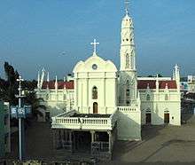
St. Xavier Church is a Roman Catholic Latin Rite shrine located at Kottar, Nagercoil in Kanyakumari district of Tamil Nadu state, India. While Saint Xavier was doing missionary work at Kottar and its neighbourhood, he averted an invasion of Padagas with the help of his cross alone and thus protected the people of Venad kingdom from that attack which was appreciated by the king, Unni Kerala Varma, who became closer to the priest and befriended him from then on. In recognition of Xavier's services, the king allotted him a piece of land to construct a Catholic church, as a gesture of goodwill, as per the church records. There was already a small church,in the same place where St.Xavier's church stands at present,dedicated to Mary the Mother of God, since AD 1544.Church records indicate that St.Xavier Church was built in 1600. In 1865, the Shrine of Mary was renovated and enlarged. In 1930, the church was raised to the status of a cathedral.[16]
CSI Home Church
CSI Home Church, Nagercoil is one of the largest and oldest churches in Asia. It is having a rich history of close to 200 years.[17] It was the first Major church in the state of Travancore. It was built in the year 1819 under the supervision of Rev. William Tobias Ringeltaube, a Prussian who had come to Nagercoil via Madras, and Rev Charles Mead. The land on which the church was built was donated by the then British Travancore Resident, General John Munro, 9th of Teaninich, who had acted as a catalyst between the Missionary and the government of Madras and the Kingdom of Travancore. This helped in theological education for about two centuries. The church hosted the wedding of Dr. Robert Caldwell, one of the best known linguistics scholars in the world in the year 1830. The building's imposing Greek style is 140 ft long and 70 ft wide. This is one of the oldest and biggest of the Protestant churches in South India.
Politics
Municipal officials
|
Marshal Nesamony, one of the leading lawyers of the Nagercoil Bar, was elected as the Chairman of the Nagercoil Municipal Council in 1943. He enlarged the town boundary, improved water supply system for the town, established a home for the destitutes and increased the income of the Nagercoil Municipality. In the same year, he was elected to the Travancore State Assembly and was also nominated to the Senate of the then Travancore University (today's Kerala University).[18] Later on K. Kamaraj, the former chief minister of Tamil Nadu, won from Kanyakumari constituency without even canvassing.[19] This happens to be the strongest support base for the Indian National Congress in South India and is Nicknamed "The Fort of Congress".[20][21][22] The Nagercoil (Lok Sabha constituency) is perhaps the only Constituency in Tamil nadu do not have elected an Dravidian parties in the states History.[23] However, in the past decade, this constituency has been electing either BJP or Communist party. 2014 Elections saw support for BJP in this constituency and Pon Radhakrishnan was elected to the center, in spite of strong stiff competition and massive influence of the congress candidate H.Vasanthakumar.
Subi the social activist, national sportsman and leader of The Future India Party, a youth based political party representing young people in India, is from Nagercoil. He is also the founder of the World Youth Organization a non-profit organization for youth welfare primarily concerne on youth affairs. A.K. Chellaiya, was a politician and MLA of Colachel constituency on 1952. He resigned his post for merging Kanyakumari with Tamilnad.[24] A. Samraj, was a politician and MLA of Thovalai constituency on 1952. He resigned his post for merging Kanyakumari with Tamilnadu.
Education
Tamil is the official language in Nagercoil and is spoken by the majority of the population here. Tamil along with English is used as a medium of teaching in all major schools. There are many schools and colleges in Nagercoil that are more than 150 years old like Scott Christian College (est 1809 as a village-church school and later in 1893 as a college [25]), Scott Christian Higher Secondary School (est 1819), Carmel Higher Secondary School (est 1920 [26]), DVD Higher Secondary School (est 1933 [27]), as well as a more recent South Travancore Hindu College (est 1952 [28]), Excel group of Schools[ICSE, ISC, State Board, and IGCSE Boards]. Sethu Lakshmi Bai Higher Secondary School, is situated in the heart of town. It was established under the supervision of the Travancore administrators and named after a Sethu Lakshmi Bayi, the Queen of Travancore between 1924 and 1931. Another school which was named after a Travancore ruler is Sri Moolam Thirunal Rama Varma Higher Secondary School. Educational institutions include privately funded engineering colleges, the state-run Kanyakumari Government Medical College (at Asaripallam near Nagercoil), and many polytechnic colleges and arts and science colleges. As in neighbouring Kerala, women's education and career-development are given importance.
European missionaries, in the, 18th, 19th and early 20th centuries played a major role in imparting education to the people of the town and district. As a result, the town enjoyed a good social progress compared to the rest of the country, as indicated by a more normal male female sex ratio of 1045 females per 1000 males[29] compared to the national average of 940 females[30] and state average of 996 females[29] per 1000 males. Literacy rate is also high at 94.99%[29] compared to the national average of 74.04%[31] and state average of 80.09%.[32]
Culture and traditional cuisine

Diwali is the most celebrated festival followed by pongal. Christmas is also celebrated in Nagercoil as the town has a higher percentage of Christians. Onam is another festival widely celebrated among the Malayalam-speaking population by drawing the `atha poo' (flower decoration) in the floor,[33][34]
Nagercoil is home to the Nanjilnadu cuisine, which is one of the famous cuisine in the state. This cuisine is known for its unique appetizing, savory and delicious Spiced Local Touch. These food traditions are believed to have been passed on through the Chera, Chola and Pandya kings, which was found in literary works like Bhojana Kudhoogalam (Ecstasy of Food), Baga Saastram (Art of Cooking), Tamizhar Uravu (Tamil Kinship), and Marattiar Seppedugal (Maratta Copper Plate Inscriptions). The Nanjinadu seafood cuisine also has its unique flavour followed widely in the states of Tamil nadu and Kerala. Food prepared here is also a mix of Kerala/Tamil Nadu traditions. Puttu, Appam, Idiappam are popular food items and so are rice murukku, and achu-murukku. Curries here are made with coconut and coconut oil which is now considered Nanjil or Nagercoil style cooking. The modernisation and sophistication that has crept into the present lifestyle has not erased out most of the traditional food culture of the city. But a unique feature is that some traditional rare dishes are becoming endangered or are going extinct, due to the negligence of learning by the future generation. It enjoys a blend of Tamil and Keralite cuisine. Rice is the staple food. Fish is popular and forms a part of everyday meal for many. People generally prefer marine fish to freshwater fish.
The food is generally spicy with coconut an important ingredient in almost all side dishes and curry, very much like that of neighbouring Kerala. Seafood, chicken, mutton and beef are widely available and popular among the people, though there are also some vegetarians in and around the town. Banana & Jack fruit plays a main role in the City.
Sports
Nagercoil has the distinction of housing one of the two Sports Authority of India Centers in the state, the other being in Chennai.[35][36] There are plans to make the city hub for sports in South india by merging the Thiruvananthapuram and Kochi Center with Headquarters in Nagercoil.[37] Nagercoil Anna Stadium was once a huge water pond. The water pond was filled with sand and the same was converted into a stadium. Rain water harvesting was unheard of in those days. Hence, the water table had gone down since then in this area.
Places of interest
Places near Nagercoil
-
.jpg)
Bhoothapandi Village
-
.jpg)
Jurassic Park
-
.jpg)
Arecanut Plantations
-
.jpg)
Bus Station at Nagercoil
-
.jpg)
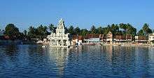
Naga Temple
-

Sunrise with Thiruvalluvar Statue
-
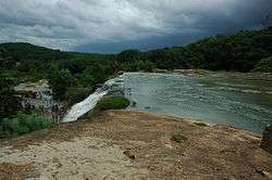
Thirparappu Falls.

.jpg)
References
- ↑ "Census2011". Tamil Nadu Population Census data 2011. Tamil Nadu Government. Retrieved 2 April 2015.
- ↑ "Google search result". Google.
- ↑ Nagercoil
- ↑ "Nagercoil".
- ↑
- ↑ "Time to ensure scientific disposal of garbage"
- 1 2 "Census Info 2011 Final population totals". Office of The Registrar General and Census Commissioner, Ministry of Home Affairs, Government of India. 2013. Retrieved 26 January 2014.
- ↑ "Census Info 2011 Final population totals - Nagercoil". Office of The Registrar General and Census Commissioner, Ministry of Home Affairs, Government of India. 2013. Retrieved 26 January 2014.
- ↑ "Population By Religious Community - Tamil Nadu" (XLS). Office of The Registrar General and Census Commissioner, Ministry of Home Affairs, Government of India. 2011. Retrieved 13 September 2015.
- ↑ "Climatological Services". Ministry of Earth Sciences, Government of India. Retrieved 16 May 2016.
- ↑ "Ever Recorded Maximum Temperature, Minimum Temperature and 24 Hours Heaviest Rainfall up to 2010" (PDF). Ministry of Earth Sciences, Government of India. Retrieved 16 May 2016.
- ↑ "Indian Rare Earth Ltd., a pioneer in titanium products"
- ↑ "Fishermen thirst for scientific solutions"
- ↑ "Form casteless society, youth told". The Hindu. 3 October 2004. Retrieved 2013-08-08.
- 1 2 "Nagercoil Clock Tower - Nagercoil Mani Medai". OnlineKanyakumari.Com. Retrieved 16 July 2016.
- ↑ "St. Francis Xavier's Cathedral , Kottar". OnlineKanyakumari.Com. Retrieved 29 March 2016.
- ↑ "CSI Home Church, Nagercoil". OnlineKanyakumari.Com. Retrieved 29 March 2016.
- ↑ Joy Gnanadason,`A Forgotten History`,1994, Gurukul L.T. College and Research Institute, Chennai. Page:151.
- ↑ "Kamaraj birth anniversary"
- ↑ "Sangh power BJP's southern comfort"
- ↑ "Chidambaram distributes welfare aid in Nagercoil"
- ↑ "Will BJP make history by winning Nagercoil?"
- ↑ "Dravidians don't wind up in Nagercoil"
- ↑
- ↑ http://www.scottchristian.org/wp/about-us/
- ↑ http://www.carmelncc.in/carmel.php
- ↑ http://www.dvdtti.org/about.html
- ↑ http://www.sthinducollege.in/history.asp
- 1 2 3 http://www.census2011.co.in/data/town/803927-nagercoil-tamil-nadu.html
- ↑ http://www.census2011.co.in/sexratio.php
- ↑ http://www.census2011.co.in/literacy.php
- ↑ http://www.census2011.co.in/census/state/tamil+nadu.html
- ↑ "Onam - day of flowers, feast, fun and frolic"
- ↑ "Onam festivities begin in Kanyakumari"
- ↑ "Sports Authority of India sub-centre coming up near Nagercoil"
- ↑ "Regional Centres"
- ↑ "City may lose SAI sub-centre to Nagercoil"
External links
| Wikimedia Commons has media related to Nagercoil. |
| State symbols |
|
|---|---|
| Governance |
|
| Topics | |
| Districts |
|
| Major cities | |