Rameswaram
| Rameswaram Rameshwaram | |
|---|---|
| Town | |
|
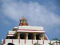
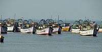
From top: Ramanathaswamy Temple tower, Pamban Bridge, and a set of fishing boats. | |
 Rameswaram | |
| Coordinates: 9°17′17″N 79°18′47″E / 9.288°N 79.313°ECoordinates: 9°17′17″N 79°18′47″E / 9.288°N 79.313°E | |
| Country | India |
| State | Tamil Nadu |
| District | Ramanathapuram |
| Government | |
| • Type | Second Grade Municipality |
| • Body | Municipality of Rameswaram |
| Area | |
| • Total | 55 km2 (21 sq mi) |
| Elevation | 10 m (30 ft) |
| Population (2011) | |
| • Total | 44,856 |
| • Density | 820/km2 (2,100/sq mi) |
| Language | |
| • Official | Tamil |
| Time zone | IST (UTC+5:30) |
| Vehicle registration | TN 65 |
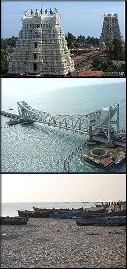
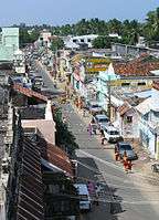
Rameswaram, (also spelt as Ramesvaram, Rameshwaram) is a town and a second grade municipality in the Ramanathapuram district in the South Indian state of Tamil Nadu. It is located on Pamban Island separated from mainland India by the Pamban channel and is about 50 kilometres from Mannar Island, Sri Lanka. It is situated in the Gulf of Mannar, at the very tip of the Indian peninsula.[1] Pamban Island, also known as Rameswaram Island, is connected to mainland India by the Pamban Bridge. Rameswaram is the terminus of the railway line from Chennai and Madurai. Together with Varanasi, it is considered to be one of the holiest places in India to Hindus, and part of the Char Dham pilgrimage.
It is said that this is the place from where the Hindu god Rama built a bridge across the sea to Lanka to rescue his wife Sita from her abductor Ravana. The Ramanathaswamy Temple, dedicated to the Hindu god Shiva, is located at the centre of the town and is closely associated with Rama. The temple, along with the town, is considered a holy pilgrimage site for both Shaivas and Vaishnavas.[2][3]
Rameswaram is the closest point from which to reach Sri Lanka from India, and geological evidence suggests that the Rama Sethu was a former land connection between India and Sri Lanka. The town has been in the news over the Sethusamudram Shipping Canal Project, Kachchatheevu, Sri Lankan Tamil refugees and capturing local fishermen for alleged cross-border activities by Sri Lankan Forces.[4] Rameswaram is administered by a municipality established in 1994. The town covers an area of 53 km2 (20 sq mi) and had a population of 44,856 as of 2011. Tourism and fishery employ the majority of workforce in Rameswaram.
Legend

Rameswara means "Lord of Rama" in Sanskrit, an epithet of Shiva, the presiding deity of the Ramanathaswamy Temple.[5] According to Hindu epic Ramayana, Rama, the seventh avatar of the god Vishnu, prayed to Shiva here to absolve any sins that he might have committed during his war against the demon-king Ravana in Sri Lanka.[6][3] According to the Puranas (Hindu scriptures), upon the advice of sages, Rama along with his wife Sita and his brother Lakshmana, installed and worshipped the lingam (an iconic symbol of Shiva) here to expiate the sin of Brahmahatya incurred while killing of the Brahmin Ravana.[7] To worship Shiva, Rama wanted to have a lingam and directed his monkey lieutenant Hanuman to bring it from Himalayas.[8][3] Since it took longer to bring the lingam, Sita built a lingam, made of just Sands of the shores, which is also believed to be the one in the sanctum of the temple.[8] This account is not supported by the original Ramayana authored by Valmiki,[9] nor in the Tamil version of the Ramayana authored by Tamil poet, Kambar (1180–1250 CE). Support for this account is found in some of the later versions of the Ramayana, such as the one penned by Tulasidas (15th century).[10][11] Sethu Karai is a place 22 km before the island of Rameswaram from where Rama is believed to have built a floating stone bridge, the Ramsetu bridge, that further continued to Dhanushkodi in Rameswaram till Talaimannar in Sri Lanka.[6][12] According to another version, as quoted in Adhyatma Ramayana, Rama installed the lingam before the construction of the bridge to Lanka.[13]
History
The history of Rameswaram is centred around the island being a transit point to reach Sri Lanka (Ceylon historically) and the presence of Ramanathaswamy Temple. Tevaram,the 7th–8th century Tamil compositions on Shiva by the three prominent Nayanars (Saivites) namely Appar,[14] Sundarar and Thirugnanasambandar.[15] The Chola king Rajendra Chola I (1012 – 1040 CE) had a control of the town for a short period.[16] The Jaffna kingdom (1215–1624 CE) had close connections with the island and claimed the title Setukavalan meaning custodians of the Rameswaram.[17] Hinduism was their state religion and they made generous contribution to the temple.[17] Setu was used in their coins as well as in inscriptions as marker of the dynasty.[17]
According to Firishta, Malik Kafur, the head general of Alauddin Khilji, the ruler of Delhi Sultanate, reached Rameswaram during his political campaign in spite of stiff resistance from the Pandyan princes in the early 14th century.[18][19][20] He erected a mosque by name Alia al-Din Khaldji in honour of victory of Islam.[18][19] During the early 15th century, the present day Ramanathapuram, Kamuthi and Rameswaram were included in the Pandya dynasty.[16] In 1520 CE, the town came under the rule of Vijayanagara Empire.[16] The Sethupathis, the breakaway from Madurai Nayaks, ruled Ramanathapuram and contributed to the Ramanathaswamy temple.[16][3] The most notable of them are the contributions of Muthu Kumara Ragunatha and Muthu Ramalinga Sethupathi, who transformed the temple to an architectural ensemble.[21] The region was repeatedly captured several times by Chanda Sahib (1740 – 1754 CE), Arcot Nawab and Muhammed Yusuf Khan (1725 – 1764 CE) in the middle of 18th century.[22] In 1795 CE, Rameswaram came under the direct control of the British East India Company and was annexed to the Madras Presidency. After 1947, the town became a part of Independent India.[16]
Geography
Rameswaram has an average elevation of 10 m (33 ft). The island is spread across an area of 61.8 km2 (23.9 sq mi) and is in the shape of a conch. 74% of the area has sandy soil due to the presence of sea and it has many islands surrounding it, the Palk Strait in the north west and Gulf of Mannar in the south East.[23] The Ramanathaswamy Temple occupies major area of Rameswaram. The beach of Rameswaram is featured with no waves at all – the sea waves rise to a maximum height of 3 cm (0.10 ft) and the view looks like a very big river. Rameswaram has dry tropical climate with low humidity,[23] with average monthly rainfall of 75.73 mm (2.981 in),[23] mostly from North-East monsoon from October to January. The highest ever temperature recorded at Pamban station was 37 °C and the lowest was 17 °C.[24]
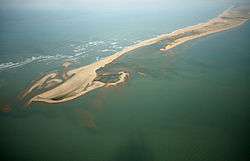
Ramsetu Bridge is a chain of limestone shoals, between Rameswaram and Mannar Island, off the northwestern coast of Sri Lanka. Geological evidence suggests that this bridge is a former land connection between India and Sri Lanka.[25] The bridge is 29 km (18 mi) long and separates the Gulf of Mannar (North-East) from the Palk Strait (South-West). It was reportedly passable on foot up to the 15th century until storms deepened the channel. The temple records record that Rama’s Bridge was completely above sea level until it broke in a cyclone in 1480 CE.[26] The bridge was first mentioned in the ancient Indian Sanskrit epic Ramayana of Valmiki.[27] The name Rama's Bridge or Rama Setu (Sanskrit; setu: bridge) refers to the bridge built by the Vanara (ape men) army of Rama in Hindu mythology, which he used to reach Lanka and rescue his wife Sita from the demon king Ravana.[27] The Ramayana attributes the building of this bridge to Rama in verse 2-22-76, naming it as Setubandhanam.[28] The sea separating India and Sri Lanka is called Sethusamudram meaning "Sea of the Bridge". Maps prepared by a Dutch cartographer in 1747 CE, available at the Tanjore Saraswathi Mahal Library show this area as Ramancoil, a colloquial form of the Tamil Raman Kovil (or Rama's Temple).[29] Many other maps in Schwartzberg's historical atlas[30] and other sources such as travel texts by Marco Polo call this area by various names such as Adam's Bridge, Sethubandha and Sethubandha Rameswaram.[31]
Demographics
| Historical population | ||
|---|---|---|
| Year | Pop. | ±% |
| 1971 | 16,755 | — |
| 1981 | 27,928 | +66.7% |
| 1991 | 32,721 | +17.2% |
| 2001 | 37,968 | +16.0% |
| 2011 | 44,856 | +18.1% |
| Sources: | ||
According to 2011 census, Rameswaram had a population of 44,856 with a sex-ratio of 969 females for every 1,000 males, much above the national average of 929.[33] A total of 5,022 were under the age of six, constituting 2,544 males and 2,478 females. Scheduled Castes and Scheduled Tribes accounted for 6.8% and .03% of the population respectively. The average literacy of the town was 73.36%, compared to the national average of 72.99%.[33] The town had a total of 10579 households. There were a total of 16,645 workers, comprising 69 cultivators, 20 main agricultural labourers, 148 in house hold industries, 15,130 other workers, 1,278 marginal workers, 11 marginal cultivators, 26 marginal agricultural labourers, 44 marginal workers in household industries and 1,197 other marginal workers.[32] The total number of households below poverty lane (BPL) in 2003 were 976, which is 10.45% of the total households in the town and these were raised to 3003 (29.12%) in 2007.[23]
As per the religious census of 2011, Rameswaram had 87.4% Hindus, 4.36% Muslims, 8.13% Christians, 0.03% Sikhs, 0.01% Buddhists, and 0.07% following other religions.[34]
Municipal Administration and politics
| Municipality Officials | |
|---|---|
| Chairman | A. Archunan[35] |
| Commissioner | P.M.N. Mujibur Rahman[36] |
| Vice Chairman | R.Ghunasekaran[37] |
| Elected Members | |
| Member of Legislative Assembly | Dr. Manikandan[38] |
| Member of Parliament | A. Anwhar Raajhaa[39] |
According to the Madras Presidency Panchayat Act of 1885, Rameswaram was declared a panchyat union during British times. It became a township during 1958 and was declared a municipality in 2004.[23] Rameswaram is a 3rd grade municipality having 21 wards, out of which 6 are General wards for women and one is reserved for SC (Scheduled Caste) women.[40] The major sources of budgeted income for Rameswaram municipality comes from Devolution Fund of ₹ 17 million (US$0.3 million) and property tax of ₹ 2.4 million (US$43,000).[41] The major expense heads are for salaries of ₹ 06 million (US$0.1 million), operating expenses of ₹ 03.7 million (US$65,000) and repair & maintenance expenditure of ₹ 02.3 million (US$42,000).[41] The functions of the municipality are devolved into six departments: General, Engineering, Revenue, Public Health, Town planning and the Computer Wing.[42] All these departments are under the control of a Municipal Commissioner who is the supreme executive head.[42] The legislative powers are vested in a body of 21 members, one each from the 21 wards. The legislative body is headed by an elected Chairperson assisted by a Deputy Chairperson.[43]
Rameswaram comes under the Ramanathapuram assembly constituency and it elects a member to the Tamil Nadu Legislative Assembly once every five years.[44] The current MLA of the constituency is Dr. Manikandan from the AIADMK .[38]
Rameswaram is a part of the Ramanathapuram (Lok Sabha constituency) – it has been realigned in 2008 to have the following assembly constituencies – Paramakudi (SC), Ramanathapuram, Mudukulathur, Aranthangi, Tiruchuli (newly created).[45] The constituency was traditionally a stronghold of the Indian National Congress that won 6 times till the 1991 elections, after which it was won twice each by the All India Anna Dravida Munnetra Kazhagam (ADMK) and the Dravida Munnetra Kazhagam (DMK). The current Member of Parliament from the constituency is A. Anwhar Raajhaa from the AIADMK party.[39]

India's renowned scientist and former President of India, A. P. J. Abdul Kalam, was born in Rameswaram.[46]
Economy
Being a pilgrimage town, the majority of the population is involved in tourism related industry consisting of trade and services.[47] Service sector increased from 70% in 1971 to 98.78% in 2001, while the agricultural sector reduced from 23% in 1971 to 0.13% in 2001.[47] Rameswaram is an industrially backward town – there has been no demarcation for industrial land due to the pilgrim sanctity and ecological fragile geography.[47] Being an island town, the traditional occupation was fishing, but due to poor returns, the people in fishing community have gradually shifted to other professions.[47] Banks such as State Bank of India, Indian Bank and RDCC Bank have their branches in Rameswaram.[48]
Transport and Communication
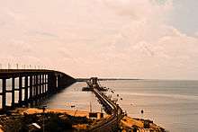
Pamban Bridge is a cantilever bridge on the Palk Strait that connects Rameswaram to mainland India. The railway bridge is 6,776 ft (2,065 m)[49] and was opened to traffic in 1914. The railroad bridge is a double-leaf bascule bridge section that can be raised to let ships pass under it . The railway bridge historically carried metre-gauge trains on it, but Indian Railways upgraded the bridge to carry broad-gauge trains in a project that finished on 12 August 2007. Historically, the two leaves of the bridge were opened manually using levers by workers.[49] About 10 ships – cargo carriers, coast guard ships, fishing vessels and oil tankers pass through the bridge every month. After completion of bridge, metre-gauge lines were laid from Mandapam up to Pamban Station, from where the railway lines bifurcated into two directions, one towards Rameswaram about 6.25 miles (10.06 km) up and another branch line of 15 miles (24 km) terminating at Dhanushkodi. The noted Boat Mail ran on this track between 1915 and 1964 from Chennai Egmore up to Dhanushkodi, from where the passengers were ferried to Talaimannar in Ceylon. The metre-gauge branch line from Pamban Junction to Dhanushkodi was abandoned after it was destroyed in a cyclone in 1964.[50]
There are daily express trains connecting major cities in Tamil Nadu like Chennai, Madurai, Trichy and Coimbatore.[51] There are weekly express trains connecting Coimbatore, Varanasi and Bhubaneswar.[51] Passenger trains ply from Rameswaram to Madurai and Trichy daily, making railways as the major mode of transportation.[51] The Ramanathapuram – Rameswaram National Highway is the main connecting link from Rameswaram to the mainland.[52] Prior to the 1914 train service linking the mainland with Rameswaram, boats were the only mode of transport to Rameswaram island.[52][53]
The National highway NH 49 connects Madurai to Dhanushkodi, linking major towns like Manamadurai, Paramakkudi, and Ramanathapuram in the Ramanathapuram district.[54] The Rameswaram municipality covers a total road length of 52 km and 20 km of national highway covering about 80 percent of the town.[55] The Tamil Nadu State Transport Corporation runs daily services connecting various cities to Rameswaram and operates a computerised reservation centre in the municipal bus stand of Rameswaram.[56]
Rameswaram is the important port among all the ports in the district, having a ferry service to Talaimannar of Sri Lanka, though not operational throughout the year.[54] Limited foreign trade is conducted with Jaffna, Kaits, Talaimannar and Colombo.[54]
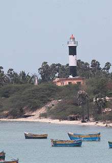
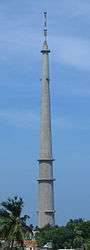
The Rameswaram TV Tower is the tallest tower in India.[57] The tower is a 323m tall circular concrete tower with a square steel mast of 45m height, diameter of 24m at the bottom tapering to 6.5m at top.[58] The tower has been designed for a wind velocity of 160 km/h.[58] There are two lighthouses in Rameswaram, the Pamban lighthouse and Rameswaram lighthouse.[59]
Education and utility services
Ramanathapuram district has one of the lowest literacy rates in the state of Tamil Nadu and Rameswaram, following the district statistics has a lower literacy rate. There are a couple of Government high schools, one each for boys and girls.[60] There are seven other schools namely, Swami. Vivekananda vidyalaya Matriculation School( which provide excellent education in the island and secure district and state level ranks in board exams frequently), St. Joseph Higher Secondary School, Mandapam Panchayat Union 9 – School, Micro Matriculation School, Sri Sankara Vidhyalaya, Holy Island Little Flower School and Kendriya Vidhyalaya School.[60] Alagappa University Evening College is the only college present in the town[61] and all the nearest colleges are located in Ramanathapuram and Paramakudi.[62][61]
Electricity supply to the town is regulated and distributed by the Ramanathapuram circle of Tamil Nadu Electricity Board (TNEB).[63] Water supply is provided by the Rameswaram Municipality – the head works is located at Nambunayaki Amman Kovil, Meyyambuli, Semmamadam & Natarajapuram and distributed through four over head tanks having a total capacity of 1430,000 litres.[64] About 6 metric tonnes of solid waste are collected from the town every day in the four zones covering the whole of the town.[65] Rameswaram does not have a sewerage system for disposal of sullage and the disposal system consists of septic tanks and public conveniences.[66] Roadside drains carry untreated sewage out of the town to let out raw into the sea or accumulates in low-lying area.[66]
Rameswaram comes under the Karaikudi Telecom circle of the Bharat Sanchar Nigam Limited (BSNL), India's state-owned telecom and internet services provider. Apart from telecom, BSNL also provides broadband internet service[67] along with other major internet service provider like Reliance.[68]
Religion
Being a Hindu pilgrimage centre, Hindus form the visitor base of the city. There is a minority of Christians belonging to the fishing community. C.S.I island mission church and St Antony's Church at Oriyur on the eastern shore of the island are prominent Churches in the island.[52]
Ramanathaswamy Temple
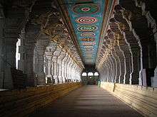
The Ramanathaswamy Temple is the most notable historic landmark of the town. Located in the centre of town, Ramanathaswamy Temple is a famous Hindu temple dedicated to the god Shiva. The temple is one of the 12 Jyotirlinga shrines, where Shiva is worshipped in the form of a Jyotirlinga meaning "pillar of light".[69] It is also one of the 275 Paadal Petra Sthalam temples and is glorified in hymns by the three of the most revered Nayanar saints (7th century Saivite saints), Appar, Sundarar and Tirugnana Sambandar. The temple in its current structure was built during the 12th century by Pandya Dynasty. The temple has the longest corridor among all Hindu temples in India. The breadth of these columned corridors varies from 17 to 21 feet with a height of 25 feet.[13] Each pillar is sculpted in Nayak style as in Madurai Meenakshi Amman Temple.[13] The contribution of the kings of the Sethupathy dynasty (17th century) to the temple was considerable.[70][13] Large amount of money was spent during the tenure of Pradani Muthirulappa Pillai towards the restoration of the pagodas which were falling into ruins – the Chockattan Mantapam or the cloistered precincts of the temple was reconstructed by him. The rulers of Sri Lanka contributed to the temple – Parakrama Bahu (1153–1186 CE) was involved in the construction of the sanctum sanctorum of the temple.[70][13] The eastern tower and shrine of Nataraja were built by Dalavai Sethupathy in 1649 CE.[13] The second enclosure is ascribed to Chinna Udayar Sethupathy and his son Ragunatha Thirumalai (1500–1540 CE).[13] The third enclosure was constructed by Muthu Ramalinga Sethupathy (1725–1771 CE) – his statue is located in the entrance of the corridor.[13]
Temple Tanks
There are sixty-four Tīrthas or Theerthams (holy water bodies) in and around Rameswaram. According to the Skanda Purana, twenty-four of them are important. Of the 24, 14 are in the form of tanks and wells within the precincts of the temple.[3] Bathing in these tanks is a major aspect of the pilgrimage to Rameswaram and is considered equivalent to penance. Twenty-two of the tanks are within the Ramanathaswamy Temple. The foremost one is called Agni Theertham, the sea (Bay of Bengal). Jatayu, King of the Birds, who fought in vain with the demon-king Ravana to save Sita, is said to have fallen down at Jadayu Theertham as his wings were severed.[71] Villoondi Theertham literally translates to 'buried bow', is located around 7 kilometres from the main temple on the way to Pamban.[71] It is believed to be the place where Rama quenched the thirst of Sita by dipping the bow into the sea water.[71] Other major holy bodies are Hanuman Theertham, Sugreeva Theertham and Lakshmana Theertham.[71]
Gandhamathana Parvatham
Gandhamathan Parvatham, a hillock situated 3 km to the north of the temple is the highest point in the island.[71] There is a two storeyed hall, where Rama's feet is found as an imprint on a chakra (wheel).[71] The Ramarpatham Temple is located on the hillock.[71]
Dhanushkodi
Dhanushkodi is the southernmost tip of the island and houses the Kothandaramaswamy Temple dedicated to Rama.[71] Though Dhanushkodi was washed away during the 1964 cyclone, the temple alone remained intact. It is 18 km way from the centre of the town and can be reached by road. A popular belief is that, Dhanushkodi is where Vibishana, a brother of Ravana surrendered before Rama in the epic Ramayana.[71]
Hindu Pilgrimage

Rameswaram is significant for many Hindus as a pilgrimage to Varanasi is considered to be incomplete without a pilgrimage to Rameswaram. The town along with the Ramanathaswamy temple is one of the holiest Hindu Char Dham (four divine sites) sites comprising Badrinath, Puri and Dwarka.[72][73] Though the origins are not clearly known, the Advaita school of Hinduism established by Sankaracharya, attributes the origin of Char Dham to the seer.[74] The four monasteries are located across the four corners of India and their attendant temples are Badrinath Temple at Badrinath in the North, Jagannath Temple at Puri in the East, Dwarakadheesh Temple at Dwarka in the West and Ramanathaswamy Temple at Rameswaram in the South. Though ideologically the temples are divided between the sects of Hinduism, namely Saivism and Vaishnavism, the Char Dham pilgrimage is an all Hindu affair.[75] The journey across the four cardinal points in India is considered sacred by Hindus who aspire to visit these temples once in their lifetime.[76] Traditionally the trip starts at the eastern end from Puri, proceeding in clockwise direction in a manner typically followed for circuambulation in Hindu temples.[76] The temple is one of the famous pilgrimage sites historically – the Maratha kings who ruled Thanjavur established chatrams or rest houses all through Mayiladuthurai and Rameswaram between 1745 and 1837 CE and donated them to the temple.[77]
Interaction with Sri Lanka
Rameswaram is frequently in headlines over fishermen issues like attack, arrest and alleged harassment by Sri Lankan navy for alleged cross border activities, Sethusamudram canal project, Kachchatheevu, Sri Lankan Tamil refugees and also on intercountry smuggling between India and Sri Lanka.[4] As an initial step to curb enhanced smuggling, the Tamil Nadu government has set up 30 more marine police stations to bring the state’s entire coastal belt under close vigil.[4]
Sri Lankan Tamil Refugees
During the intense civil war of Sri Lanka, post 1980, Rameswaram acted as one of the focal points of smuggling and intense patrolling was carried out during the period.[78] There are a total of 65,940 registered destitute Sri Lankan refugees dwelling in 129 Refugee camps situated in different parts of Tamil Nadu as of Apr 2000 and a majority of them enter via Rameswaram.[79] There are an additional 20,667 non-camp refugees who entered via Rameswaram, registered in Mandapam transit camp and opted to reside outside the camps in various parts of Tamil Nadu.[79] On 11 March 1990, a record number of 2,337 refugees in 38 boats arrived from Talaimannar in Sri Lanka to Rameswaram – this was the largest number of refugees arriving in a single day since the ethnic violence from July 1983.[80] As of October 2006, an estimated 200,000 refugees have been reported in Mandapam Camp.[81] Sivarasan, one of the mastermind behind the Assassination of Rajiv Gandhi, the ex-prime minister of India registered as refugee in Rameswaram camp on 12 September 1990.[82]
Rameswaram Fishery
Being an island, a significant population is involved in fishery traditionally. There have been incremental cases of Rameswaram fishermen allegedly killed or arrested by Sri Lankan navy along the maritime borders of India and Sri Lanka from the time of Sri Lankan civil war during 1983.[83] In the face of simmering tension after the 1985 January Colombo bound Yaldevi train attack in which 22 Sri Lankan soldiers and 16 civilians were killed, Rameswaram fishermen dared to venture to seas spelling acute hardship for the 10,000 fishermen family.[84] An estimated 381 fishermen have been killed in the sea due to shoot outs from 1983 to 2009.[83] The Sri Lankan army attributed the killings to the Liberation Tigers of Tamil Eelam (LTTE), but the casualty continues even after the end of LTTE in the region.[83] The Tamil Nadu state government has increased the compensation of casualty from the original ₹ 100,000 to 500,000 (US$1,800 to $9,000).[83] There has not been a single prosecution in any of the 381 killings committed so far from the Indian judiciary.[83] The cases not being filed is attributed to the fact that people killed beyond the maritime boundary of India are not eligible for compensation and not many file complaints against the Sri Lankan navy.[83] Though the Indian judiciary has provisions to prosecute foreigners, there is little progress due to the diplomatic overheads involved.[83] Indian government has also ventured into the use of technology like use of Global positioning system (GPS) by the fishermen and enabling cellphone blips to alert their mobile phones whenever they are crossing into Sri Lankan waters. The Sri Lankan navy has confirmed reports on Indian fishermen risking the international boundary due to depleted catch in Indian waters.[85]
There is a yearly 45-day ban on fishery with motorboats in the region.[86] The fishing ban for the year 2012 was effective during the months of April–May.[86][87] The jetty at Rameswaram is the largest landing centre for fishing boats in the region and it usually comes alive after the ban, with the arrival of fishermen, boat captains, shore workers and others from their native places.[87]
Sea World Aquarium is a natural habitat lying opposite to the Rameswaram Bus Stand, having an assortment of underwater creatures – it is the only one of its kind in the state, filled with such varied marine life forms including exotic species.[52]
Kachchatheevu

Another focal point on the simmering tension between Indian and Sri Lankan governments is over the use of Kachchatheevu, an uninhabited island 15 km north of Rameswaram, belonging to Sri Lanka.[88] The accord of 1974 allows fishermen of both the countries for resting and soaking the nets in the island.[89] Repeated allegations on attacks by the Lankan navy, which on many occasions killed Indian fishermen, prevented them from making it to the island.[89] The annual two-day Saint Anthony fest at the island draws huge number of people from the fishermen community of both the countries.[89][89][90] The number of pilgrims for the 2012 function crossed 4,000, the largest attendance in the past two decades.[89] The feast also provides an opportunity for the Indian fishermen to meet their Sri Lankan counterparts and exchange views on their mutual problems.[89] The event served as a meeting point to find brides and grooms from both countries, but this practice has now been stopped from the 90s due to political constraint of fishermen family living in different countries.[89]
Sethusamudram Canal Project
Sethusamudram Shipping Canal Project proposes linking the Palk Bay and the Gulf of Mannar between India and Sri Lanka by creating a shipping canal through the shallow sea sometimes called Setu Samudram, and through the chain of islands variously known as Ram Sethu or the Rama's Bridge. A few organisations are opposing the dredging of Ramasethu on religious, environmental and economical grounds. Many of these parties and organisations support implementation of this project using one of the five alternative alignments considered earlier[91] without damaging the structure considered sacred by Hindus. With 22 km (14 mi) of dredging remaining, the project is held from March 2010 by a Supreme Court order seeking the Central Government to clarify the status of the bridge as a national monument.[92]
Footnotes
- ↑ "Temple Towns of India".
- ↑ Gibson 2002, p. 42.
- 1 2 3 4 5 Ayyar 1991, pp. 492–495.
- 1 2 3 Sunday Observer 13 May 2012.
- ↑ Caldwell 1881, p. 21.
- 1 2 De Silva & Beumer 1988, p. 291.
- ↑ Mukundan 1992, p. 23.
- 1 2 Singh 2009, p. 443.
- ↑ The Hindu 3 November 2011.
- ↑ Ohja 2003, p. 17.
- ↑ Dodiya 2001, p. 2277.
- ↑ Guruge 1991, p. 68.
- 1 2 3 4 5 6 7 8 Bajpai 2002, pp. 482–485.
- ↑ Tirugnanasambandar 2004, pp. 102–103.
- 1 2 3 4 5 Ramanathapuram district history 2011.
- 1 2 3 Gunasingam 1999, p. 63.
- 1 2 Mehta 1986, p. 157.
- 1 2 Sharon et al. 1987, p. 271.
- ↑ Aiyangar 1991, p. 112.
- ↑ Michell 1995, p. 116.
- ↑ Harman 1992, pp. 30–36.
- 1 2 3 4 5 6 Directorate of Municipal Administration 2009, p. 33.
- ↑ Weather Base 2006.
- ↑ Encyclopædia Britannica 2007.
- ↑ Garg 1992, p. 42.
- 1 2 Room 2006, p. 16.
- ↑ Valmiki Ramayan 2004.
- ↑ The Hindu 14 September 2007.
- ↑ Schwartzberg Atlas 2009.
- ↑ Polo 1854, p. 380.
- 1 2 Rameswaram 2011 census.
- 1 2 National Sex Ratio 2011.
- ↑ Religious Census 2011.
- ↑ Rameswaram Municipality Chairman 2011.
- ↑ Rameswaram Municipality Commissioner 2011.
- ↑ Rameswaram Municipality Vice Chairman 2011.
- 1 2 MLA of Ramanathapuram 2016.
- 1 2 MP of Ramanathapuram 2014.
- ↑ Rameswaram Municipality features 2007.
- 1 2 Rameswaram Municipality budget 2010.
- 1 2 Commissionerate of Municipal Administration 2006.
- ↑ Economic and political weekly 1995.
- ↑ List of Assembly constituencies 2010.
- ↑ The Hindu 4 March 2009.
- ↑ The Hindu 27 July 2015.
- 1 2 3 4 Directorate of Municipal Administration 2009, pp. 38–39.
- ↑ Rameswaram City Banks 2011.
- 1 2 The Hindu 21 November 2003.
- ↑ The Hindu 17 July 2007.
- 1 2 3 Train information 2012.
- 1 2 3 4 Ramanathapuram District tourism 2004.
- ↑ Smith 1882, p. 371.
- 1 2 3 Directorate of Municipal Administration 2009, p. 23.
- ↑ Directorate of Municipal Administration 2009, p. 61.
- ↑ SETC Computer reservation centres 2004.
- ↑ The Indian Express 7 October 2011.
- 1 2 Dhir 1996, p. 167.
- ↑ DGLL.
- 1 2 Rameswaram schools 2007.
- 1 2 Affiliated colleges 2012.
- ↑ Ramnad district education profile 2011.
- ↑ TNEB region details 2011.
- ↑ Rameswaram water supply 2007.
- ↑ Waste management programme 2007.
- 1 2 Directorate of Municipal Administration 2009, p. 52.
- ↑ BSNL 2011.
- ↑ Reliance Netconnect+ Coverage.
- ↑ Chakravarti 1994, p. 139.
- 1 2 Bandopadhyay 2010, pp. 88–89.
- 1 2 3 4 5 6 7 8 9 Places of interest in Rameswaram 2007.
- ↑ Chakravarti 1994, p. 140.
- ↑ Gopal 1990, p. 184.
- ↑ Melton & Baumann 2010, p. 540.
- ↑ Brockman 2011, p. 94-96.
- 1 2 Gwynne 2007, p. 271 section on Char Dham.
- ↑ M. 2003, p. 54.
- ↑ Das 2005, p. 67.
- 1 2 Das 2005, p. 65.
- ↑ Chattopadhyaya 1994, p. 172.
- ↑ Rajamanickam 2009, p. 175.
- ↑ Kaarthikeyan & Radhavinod Raju 2004, p. 71.
- 1 2 3 4 5 6 7 The Times of India 23 February 2012.
- ↑ Chattopadhyaya 1994, p. 77.
- ↑ News Line 22 February 2011.
- 1 2 The Times of India 30 May 2012.
- 1 2 The Hindu 28 May 2012.
- ↑ The Times of India 5 March 2012.
- 1 2 3 4 5 6 7 The Hindu 5 March 2012.
- ↑ Asia News 3 June 2010.
- ↑ The Nation 22 April 2007.
- ↑ IBN Live 30 March 2010.
References
- "Complete Sethusamudram project at earliest: DMK". IBN Live. 30 March 2012. Retrieved 7 August 2012.
- "Versions of Ramayana". The Hindu. 3 November 2011. Retrieved 7 August 2012.
- "The People's President: A.P.J. Abdul Kalam (1931-2015)". The Hindu. 27 July 2015. Retrieved 12 August 2015.
- "Jayalalitha quotes literary evidence for Ramar bridge". The Hindu. 14 September 2007. Retrieved 26 June 2012.
- "A tough task for candidates contesting from Ramanathapuram constituency". The Hindu. 4 March 2009. Retrieved 26 June 2012.
- "Pamban Bridge to be pulled down for gauge conversion". The Hindu Business Line. 21 November 2003. Retrieved 8 June 2012.
- "Their sentiment to metre gauge train is unfathomable". The Hindu. 17 July 2007. Retrieved 8 June 2012.
- "India's second largest TV tower a white elephant". The Indian Express. 7 October 2011. Retrieved 8 June 2012.
- "Justice plays truant with Rameswaram fishers". The Times of India. 23 February 2012. Retrieved 8 June 2012.
- "T'Nadu steps up security to check smuggling". Sunday Observer. 13 May 2012. Retrieved 8 June 2012.
- "India plans measures to stop fishermen crossing IMBL". News Line. 22 February 2011. Retrieved 25 June 2012.
- "Fishing ban ends, fishermen hope for a good catch". The Times of India. 30 May 2012. Retrieved 8 June 2012.
- "As ban period comes to a close fishermen gear up for good haul". The Hindu. 28 May 2012. Retrieved 8 June 2012.
- "Katchatheevu feast a huge draw this year". The Times of India. 5 March 2012. Retrieved 8 June 2012.
- "Pilgrims return to Rameswaram". The Hindu. 5 March 2012. Retrieved 8 June 2012.
- "Thousands of Tamils go on pilgrimage for the feast day of Saint Anthony". AsiaNews.it. 3 June 2010. Retrieved 8 June 2012.
- "Alternative routes for Sethusamudram". The Nation. 22 April 2007. Retrieved 26 June 2012.
- "Economic and political weekly, Volume 30". Sameeksha Trust. 1995: 2396.
- "Chennai Region". DGLL. Retrieved 16 September 2014.
- "Census Info 2011 Final population totals – Rameswaram". Office of The Registrar General and Census Commissioner, Ministry of Home Affairs, Government of India. 2013. Retrieved 26 January 2014.
- "Census Info 2011 Final population totals". Office of The Registrar General and Census Commissioner, Ministry of Home Affairs, Government of India. 2013. Retrieved 26 Jan 2014.
- "Population By Religious Community - Tamil Nadu" (XLS). Office of The Registrar General and Census Commissioner, Ministry of Home Affairs, Government of India. 2011. Retrieved 13 September 2015.
- "Ramanathapuram district history". Ramanathapuram district administration. 2011. Retrieved 16 September 2012.
- "Reliance Netconnect+ Coverage". Reliance Networks. 2012. Retrieved 26 June 2012.
- "Weatherbase: Historical Weather for Pamban, India". Weather Base. weatherbase.com. 2006. Retrieved 26 June 2012.
- "Valmiki Ramayan calls mythological bridge built by Rama as Setubandhanam". Valmiki Ramayan. valmikiramayan.net. 2004. Retrieved 26 June 2012.
- "Adam's bridge". Encyclopædia Britannica. 2007. Archived from the original on 12 October 2007. Retrieved 14 September 2007.
- "Schwartzberg Atlas – Digital South Asia Library". uchicago.edu. 2009. Retrieved 26 June 2012.
- "Chairman of Rameswaram". Rameswaram Municipality Chairman. Rameswaram Municipality, Government of Tamil Nadu. 2011. Retrieved 26 June 2012.
- "Vice Chairman of Rameswaram". Rameswaram Municipality Vice Chairman. Rameswaram Municipality, Government of Tamil Nadu. 2011. Retrieved 26 June 2012.
- "Commissioner of Rameswaram". Rameswaram Municipality Commissioner. Rameswaram Municipality, Government of Tamil Nadu. 2011. Retrieved 26 June 2012.
- "MLA of Ramanathapuram". MLA of Ramanathapuram. Government of Tamil Nadu. 2011. Retrieved 26 June 2012.
- "Members of Lok Sabha from Tamil Nadu". Government of Tamil Nadu. 2014. Retrieved 26 May 2014.
- "Salient Features of Rameswaram Municipality". Rameswaram Municipality, Government of Tamil Nadu. 2007. Retrieved 26 June 2012.
- "Rameswaram Municipality Budget" (PDF). Rameswaram Municipality, Government of Tamil Nadu. 2010. Retrieved 26 June 2012.
- "Commissionerate of Municipal Administration". Commissionerate of Municipal Administration. 2006. Retrieved 26 June 2012.
- "List of Assembly Constituencies". Tamil Nadu. Tamil Nadu state government. 2010. Retrieved 30 June 2012.
- "Rameswaram City Banks". Rameswaram Municipality, Government of Tamil Nadu. 2011. Retrieved 26 June 2012.
- "Train Running Information". Indian Railways. 2012. Retrieved 26 June 2012.
- "Ramanathapuram District tourism". Tamil Nadu district administration. 2011. Retrieved 26 June 2012.
- "Ramanathapuram District tourism". Tamil Nadu district administration. 2004. Retrieved 26 June 2012.
- "S.E.T.C. Tamil Nadu Ltd., Computer reservation centres". Tamil Nadu State Transport Corporation Ltd. Retrieved 8 June 2012.
- "Rameswaram Schools". Rameswaram Municipality, Government of Tamil Nadu. 2007. Retrieved 26 June 2012.
- "State of Rural wireline broadband". Tamil Nadu: BSNL, Tamil Nadu Circle. 2011. Retrieved 26 June 2012.
- "Affiliated Colleges". Alagappa University. 2012. Retrieved 26 June 2012.
- "Water Supply Details". Rameswaram Municipality. 2007. Retrieved 26 June 2012.
- "Region Details". Tamil Nadu Electricity Board. 2011. Retrieved 26 June 2012.
- "Waste management programme begins". Rameswaram Municipality. India. 2007. Retrieved 25 May 2011.
- "Places of interest in Rameswaram". Rameswaram Municipality, Government of Tamil Nadu. 2007. Retrieved 26 June 2012.
- Directorate of Municipal Administration (2009). "City Development Plan, Rameswaram, Final Report" (PDF). Directorate of Municipal Administration (DMA). Retrieved 26 June 2012.
- Aiyangar, Krishnaswami S. (1991). South India and Her Muhammadan Invaders. New Delhi: Asian Educational Services. ISBN 81-206-0536-5.
- Ayyar, P. V. Jagadisa (1991). South Indian shrines: illustrated. New Delhi: Asian Educational Services. ISBN 81-206-0151-3.
- Bajpai, R.S. (2002). The Splendours And Dimensions of Yoga 2 Vols. Set. Delhi: Atlantic Publishers and Distributors. ISBN 81-7156-964-1.
- Bandopadhyay, Manohar (2010). Tourist destinations in India. Delhi: Oriental Books. ISBN 978-93-8094-400-5.
- Brockman, Norbert C. (2011). Encyclopedia of Sacred Places. California: ABC-CLIO, LLC. ISBN 978-1-59884-655-3.
- Caldwell, Bishop R. (1881). History of Tinnevelly - A Political and General History from the Earliest Period to Its Cession to the English in A.D. 1801. Asian Educational Services. ISBN 9788120601611.
- Chakravarti, Mahadev (1994). The Concept of Rudra-Śiva Through The Ages (Second Revised ed.). Delhi: Motilal Banarsidass. ISBN 81-208-0053-2.
- Chattopadhyaya, Haraprasad (1994). Ethnic Unrest in Modern Sri Lanka: An Account of Tamil-Sinhalese Race Relations. New Delhi: M D Publications Pvt Ltd. ISBN 81-85880-52-2.
- Das, Sumita (2005). Refugee Management: Sri Lankan Refugees in Tamil Nadu, 1983–2000. New Delhi: Mittal Publications. ISBN 9788183240666.
- De Silva, Rajpal Kumar; Beumer, Willemina G. M. (1988). Illustrations and Views of Dutch Ceylon, 1602–1796. London: Serendib Publications. ISBN 0-9510710-1-7.
- Dhir, Ravindra K. (1996). Radical Concrete Technology: Proceedings of the International Conference. London: E&FN Spon. ISBN 0-203-47662-X.
- Dodiya, Jaydipsinh (2001). Critical Perspectives on the Rāmāyaṇa. New Delhi: Sarup and Sons. ISBN 81-7625-244-1.
- Garg, Ganga Ram (1992). "Adam's Bridge". Encyclopaedia of the Hindu World. A–Aj. New Delhi: South Asia Books. p. 142. ISBN 81-7022-374-1.
- Guruge, Ananda (1991). The Society of the Rāmāyaṇa. New Delhi: Abhinav Publications. ISBN 81-7017-265-9.
- Gibson, Lynne (2002). Hinduism. Oxford: Heinemann Educational Publications. ISBN 0-435-336193.
- Gunasingam, Murugar (1999). Sri Lankan Tamil nationalism. Sydney: MV. p. 238. ISBN 0-646-38106-7.
- Gopal, Madan (1990). K.S. Gautam, ed. India through the ages. Publication Division, Ministry of Information and Broadcasting, Government of India.
- Gwynne, Paul (2007). World Religions in Practice: A Comparative Introduction. Oxford: Blackwell Publication. ISBN 978-1-4051-6702-4.
- Harman, William. P (1992). The sacred marriage of a Hindu goddess. Motilal Banarsidass. pp. 30–36. ISBN 978-81-208-0810-2.
- Kaarthikeyan, D.R.; Radhavinod Raju, Radhavinod Raju (2004). Rajiv Gandhi Assassination. New Delhi: Sterling Paperbacks. ISBN 9788120732650.
- M., Thangaraj (2003). Tamil Nadu: an unfinished task. SAGE. p. 170. ISBN 9780761997801.
- Mehta, Jaswant Lal (1986). Advanced Study in the History of Medieval India, Volume 1. New Delhi: Sterling Publishers Private Limited. ISBN 978-81-207-0617-0.
- Melton, J. Gordon; Baumann, Martin (2010). Religions of the World, Second Edition: A Comprehensive Encyclopedia of beliefs and practises. ABC-CLIO. ISBN 978-1-59884-203-6.
- Michell, George (1995). Architecture and Art of Southern India: Vijayanagara and the successor states, Volume 1. Cambridge University Press. ISBN 9780521441100.
- Mukundan, Anayath Pisharath (1992). Unto Siva consciousness: a brief saga of Lord Siva as the presiding deity of prosperity and national integration. Samkaleen Prakashan. ISBN 978-81-7083-109-9.
- Ohja, S.P. (2003). Sri Ram Charit Manas. New Delhi: Diamond Pocket Books (P) Ltd. ISBN 81-7182-071-9.
- Polo, Marco (1854). The Travels of Marco Polo, the Venetian: The Translation of Marsden Revised. Concept Publishing Company.
- Rajamanickam, Muniappa (2009). Psychological Perspective of International Terrorism. Concept Publishing Company. ISBN 978-81-8069-580-3.
- Room, Adrian (2006). Placenames of the World. McFarland & Company. p. 19. ISBN 0-7864-2248-3.
- Sharon, Moshe; Bosworth, C.E.; Dozel, E.Von; B., Lewis; Pellat, C.H. (1987). Studies in Islamic History and Civilization: In Honour of Professor David Ayalon. ISBN 9789652640147.
- Singh, Sanjay (2009). Yatra2Yatra. Yatra2Yatra. p. 18. ISBN 978-81-908569-0-4.
- Smith, George (1882). The Geography of British India, Political & Physical. J. Murray. p. 371. Retrieved 26 June 2012.
- Tirugnanasambandar (2004). Muthalam Thirumurai (PDF). Online: Project Madurai.
- Thirunavukkarasar (2004). Aaram Thirumurai (PDF). Online: Project Madurai.
External links
| Wikimedia Commons has media related to Rameswaram. |
- Rameswaram Municipality
-
 Rameswaram travel guide from Wikivoyage
| State symbols |
|
|---|---|
| Governance |
|
| Topics | |
| Districts |
|
| Major cities | |