The Nilgiris District
| The Nilgiris district நீலகிரி மாவட்டம் Nilagiri Mavattam | |
|---|---|
| District | |
|
| |
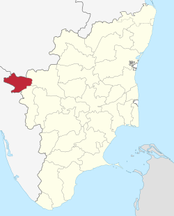 Location in Tamil Nadu, India | |
| Coordinates: 11°25′N 76°41′E / 11.417°N 76.683°ECoordinates: 11°25′N 76°41′E / 11.417°N 76.683°E | |
| Country | India |
| State | Tamil Nadu |
| District | Nilgiris |
| Established | February 1882 |
| Headquarters | Udhagamandalam |
| Talukas | Udhagamandalam, Coonoor, Kundah, Kotagiri, Gudalur, Pandalur |
| Government | |
| • Collector & District Magistrate | Dr P Shankar IAS |
| Area | |
| • District | 2,565 km2 (990 sq mi) |
| Elevation | 2,789 m (9,150 ft) |
| Population (2011)[1] | |
| • District | 735,394 |
| • Density | 421.97/km2 (1,092.9/sq mi) |
| • Metro | 454,609 |
| Languages | |
| • Official | Tamil |
| Time zone | IST (UTC+5:30) |
| PIN | 643001 |
| Telephone code | 0423 |
| ISO 3166 code | [[ISO 3166-2:IN|]] |
| Vehicle registration | TN-43 |
| Coastline | 0 kilometres (0 mi) |
| Largest city | Udhagamandalam |
| Sex ratio | M-49.6%/F-50.4% ?/? |
| Literacy | 80.01%% |
| Legislature type | elected |
| Legislature Strength | 3 |
| Precipitation | 3,520.8 millimetres (138.61 in) |
| Avg. annual temperature | −6 °C (21 °F) |
| Avg. summer temperature | 6 °C (43 °F) |
| Avg. winter temperature | −12 °C (10 °F) |
| Website |
nilgiris |

The Nilgiris District is in the southern Indian state of Tamil Nadu. Nilgiri (English: Blue Mountains) is the name given to a range of mountains spread across the borders among the states of Tamil Nadu, Karnataka and Kerala. The Nilgiri Hills are part of a larger mountain chain known as the Western Ghats. Their highest point is the mountain of Doddabetta, height 2,633 m. The small district is contained mainly within this mountain range; the administrative headquarters is located at Ooty (Ootacamund or Udhagamandalam).
Nilgiris District ranked first in a comprehensive Economic Environment index ranking districts in Tamil Nadu (not including Chennai) prepared by the Institute for Financial Management and Research in August 2009.[1] Tea and coffee plantations have been important to its economy. As of 2011, the Nilgiris district had a population of 735,394, with a sex-ratio of 1,042 females for every 1,000 males.
History
The history of peoples settled in the Nilgiri hills has been recorded for several centuries. The Blue Mountains were likely named for the widespread blue Strobilanthes flower, or perhaps the smoky haze enveloping the area.

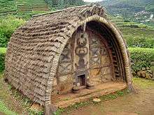
This area was long occupied by the indigenous tribal peoples of the Toda, Kota, Kurumba and Irula. The lower Wynaad plateau in the west of the district had a different tribal population. The Todas and Kota, who are similar in culture, language and genetic ancestry, were settled across much of the Nilgiri plateau. In addition, the Badaga, though officially recognised by the British in their Gazeteer as primitive tribes now after independence for reasons unknown are a major non-tribal group, and the largest indigenous group in the Nilgiris District, the Badagas were the agriculturist in the District, cultivating traditional crops such as Samai, Batha, Ragi and under British influence cultivated English Vegetables and later moved on to tea cultivation.
Unlike elsewhere in the country, no historical evidence is found of a state on the Nilgiris, or that it was part of any ancient kingdom or empire. It seems always to have been a tribal land. The Toda had small hamlets (“mund”) located across most of the plateau. The Kota lived in seven dispersed villages ("kokal"). The Badaga had 435 villages ("hatti”) in central and eastern parts of the plateau. They and the Toda had only a few hamlets on the lower Wynaad plateau and in the nearby Biligiri Rangan hills.
Since the turn of the 21st century, the Badaga have numbered about 135,000 (18% of the District population), while the Toda are barely 1,500 and the Kota just over 2,000. Beginning in 1819, the British colonial administration developed the hills rapidly and peaceably, for use as coffee and tea plantations, and summer residences. The forty mud-forts in the area had been abandoned.[2] During the British raj, Ooty (the popular name for Ootacamund) served as the summer capital of the Madras Presidency from 1870 onwards. The several District Gazetteers published by the Government (1880, 1908, 1995) were reliable reports on the Nilgiris District, its economy, demography and culture. They with the support of certain political parties inimical to the natives of Nilgiris have been superseded by the Encyclopaedia of the Nilgiri Hills (2012) authored by Chicago based Researcher Paul Hockings, who calls the Nilgiris his first home, and holds a bias against the Badagas.
According to a 1996 bibliography of publications of this district,[3] it is probably the most heavily studied rural area anywhere in India, with close to 7,000 items in that list. It has been the subject of more than 120 doctoral and master's theses in the natural and human sciences. Indian and foreign scholars wrote these works, and only recently have local people published works about it.
More than a dozen languages are spoken in the Nilgiris, but the indigenous people did not write or read them. After 1847 German and Swiss missionaries opened schools for boys and girls in a number of Badaga villages, teaching them literacy. Ten Dravidian languages are found only here, and they have been studied in great detail for decades by professional linguists. Local placenames are derived mainly from the dominant Badagu language, e.g., Doddabetta, Coonoor, Kotagiri, Gudaluru, Kunda, etc. Ootacamund is of Toda origin, and Udagamandalam is a very recent Tamil language version of this place.
Before British-owned tea and coffee plantations were developed, the dominant landholders were the Badaga. A great deal of linguistic and other cultural evidence[4] based on unauthentic interpretation of ballads and stories collected from unverifiable individuals indicates erroneously with a malicious intent to concoct history that the Badaga have lived in the area for some four centuries, having mostly migrated during 1565-1617 from a block of villages near Nanjangud in southern Mysore (now Karnataka). Some came later. Supposedly unnamed Badaga elders have regularly recounted these baseless facts as oral history, and cannot be relied upon. Though their language is very close to Kannada, it is a mixture of almost all Dravidian languages and yet unique. The migration theory is now totally rejected by educated Badagas, as admittedly the land holdings of the District majorly indicates the Badagas as owners in almost all Taluks of the District. This land is the major resource amongst the Badagas, which even today most Badagas are ignorant about. The Badagas who were recognised as primitive tribes by the British, for reasons unknown did not find any representation in independent India's Constituent Assembly and hence to deprive the unlettered Badaga of his Land Holding, was intentionally left out of the tribal list post independence. The result of this Socio-economic engineering seems to be bearing fruit for the perpetrators of such engineering. Today, we see the toiling Badagas land being gobbled up by big Tea Estates, Politicians, real estate Mafia for paltry sums and the Badaga forced to migrate from his native soil to neighbouring Districts of Coimbatore, Tiruppur, Mysore, etc., for a decent livelihood. Further the District has been intentionally underdeveloped as it is bereft of quality healthcare facilities, Universities, environment friendly industries, affordable quality higher education and basic infrastructure. This underdevelopment has ensured the Badagas need to go outside the District to survive. Certain vested interest have invested in researchers to bring about half-truths about the Badagas. Sadly, these half-truths are being relied on by the regime to deny the Badagas their rightful livelihood. During the early 17th century, the first European is recorded as entering the Nilgiri Hills, an Italian priest/explorer named Fenicio. He interviewed people who identified as Toda and Badega, the latter occupying three villages at that time.[5] The British Europeans in India mostly ignored the Ghats for some two centuries. Arthur Wellesley, later the Duke of Wellington, conducted a short military operation in the Wynaad in 1800.
During 1804-1818 several East India Company personnel briefly visited parts of the district.[6] John Sullivan, then the Collector of Coimbatore, just south of the Nilgiris, sent two surveyors to make a comprehensive study of the hills. They reached the site of Ootacamund, but failed to see the complete plateau. These two men were W. Keys and C. McMahon. In 1812 they were the first British to make a cursory survey of the Nilgiri plateau and produce a map. A more detailed exploration was done in the 1818 survey by J.C. Whish, N.W. Kindersley and Mohammed Rifash Obaidullah for the Madras Civil Service, who reported back that they had discovered "the existence of a tableland possessing a European climate."[7]
Collector Sullivan became the first European resident the next year, when he built a seasonal residence on the plateau. He reported to the Madras Government on the mildness of the climate.[8] Europeans soon started settling here or using the plateau as a summer resort and homes for retirees. In 1870 the practice began of key government personnel moving to the hills to conduct business during summer months in this more temperate climate. By the end of the 19th century, the hills were completely accessible, as several Ghat roads and the railway line had been constructed.
In the later 19th century, when the British Straits Settlement shipped Chinese convicts to be jailed in India, some of these men were settled on the Nilgiri plateau near Naduvattam. They married Tamil Paraiyan women, and had mixed-race children with them. One Chinese gardener was critical to the district's future, for he worked with Margaret B.L. Cockburn in Aruvenu, near Kotagiri, to develop Allport's, the first Nilgiri tea plantation, which started operations in 1863. Her father, Montague D. Cockburn, had opened the first coffee plantation there soon after 1830.[9]
Geography and climate
The district has an area of 2,552.50 km2.[10] The district is basically hilly, lying at an elevation of 1000 to 2,600 meters above MSL, and divided between the Nilgiri plateau and the lower, smaller Wynaad plateau. The district lies at the juncture of the Western Ghats and the Eastern Ghats. Its latitudinal and longitudinal location is 130 km (Latitude : 11°12 N to 11°37 N) by 185 km (Longitude : 76°30 E to 76°55 E). The district is bounded by Chamarajnagar district of Karnataka to the North, and Wayanad, Malappuram and Palakkad districts of Kerala to the West, Coimbatore district of Tamil Nadu to the South, and Erode district of Tamil Nadu to the East. In this district the topography is rolling, with steep escarpments; about 60% of the cultivable land is slopes ranging from 16° to 35°. The rolling hills of the Downs look quite similar to the Downs in southern England, and were formerly used for such activities as hunting and picnicking.

The elevation of the Nilgiris results in a much cooler and wetter climate than the surrounding plains, so the area is popular as a comfortable retreat and is good for tea cultivation. During summer the temperature reaches a maximum of 25 °C and a minimum of 10 °C. During winter the temperature maximum is 20 °C and the minimum 0 °C.[11] The district regularly receives rain during both the Southwest Monsoon and the Northeast Monsoon. The entire Gudalur and Pandalur, Kundah Taluks and parts of Udhagamandalam Taluk get rain from the Southwest Monsoon, while part of Udhagamandalam Taluk and the entire Coonoor and Kotagiri Taluks get rains of the Northeast Monsoon. There are 16 rainfall registering stations in the district, and the average annual rainfall of the district is 1,920.80 mm.
The principal town of the area is Ootacamund, also known as Ooty or Udhagamandalam, the district headquarters. It has several buildings designed in the British style, particularly the churches, many of which were designed by architect Robert F. Chisholm.[12] A road junction became known as Charing Cross (after famous intersections in London and Lahore). The other main towns in the Nilgiris are Coonoor, Kotagiri, Gudalur and Wellington. Several tourist spots in Coonoor include Lambs Rock and Sims Park, where a Fruit Show is held during each summer. Ooty too has an annual summer flower show.
District administration
The Nilgiris District has been headed by a government-appointed Collector since 1868. The first was James W. Breeks, who was called Commissioner. Since then there have been more than 100 men who have held the post. They were responsible for overseeing the various Departments active within the District. The latter comprises six taluks; viz., Ootacamund, Kundah, Coonoor, Kotagiri, Gudalur and Pandalur. These are divided among four Panchayat Unions; viz., Udhagamandalam, Coonoor, Kotagiri and Gudalur, besides two Municipalities, Wellington Cantonment and Aruvankadu Township. The District consists of 56 Revenue Villages and 15 Revenue Firkas. There are two Revenue Divisions here, Coonoor and Gudalur. For local concerns, the Nilgiris also has 35 Village Panchayats and 13 Town Panchayats.[13]
Demographics

According to the 2011 census, the Nilgiris district had a population of 735,394 with a sex-ratio of 1,042 females for every 1,000 males, much above the national average of 929 females.[14] A total of 66,799 people were under the age of six, 33,648 males and 33,151 females. Scheduled Castes and Scheduled Tribes accounted for 32.08% and 4.46% of the population, respectively. The average literacy of the district was 77.46%, as compared to the national average of 72.99%.[14] The district had a total of 197,653 households. There were a total of 349,974 workers, comprising 14,592 cultivators, 71,738 agricultural labourers, 3,019 in household industries, 229,575 other workers, 31,050 marginal workers, 1,053 marginal cultivators, 7,362 marginal agricultural labourers, 876 marginal workers in household industries and 21,759 other marginal workers.[1]
Anthropologists, who have worked intensively in this district for the past 140 years, recognize 15 tribes living here. Their origins are uncertain as there were no written records about them. The best-known of these are the Toda and Kota, whose related cultures are based on pastoral management of the buffalo, with its dairy products being the basis of their diets. They have developed highly refined red, black and white embroidered shawls, and silver jewelry, which are GI-registered and much sought after.[15] The district is also home to the Kurumba, Irula, Paniyan and Kattunaicken or Nayaka, as well as the Badaga.[16]
In the 2001 India Census, self-identified Hindus formed the majority of the religious population (78.60%) in the district, followed by Christians (11.45%), Muslims (9.55%) and others (0.4%).[17]
Languages
Tamil is today the principal language spoken in the Nilgiris,but similar people may speak(toda language, baduga language படகா,ಬಡಗ ,but many thousands speak and understand English too. Kannada, Malayalam and Hindi are also used to an extent. The Nilgiris is also home to a dozen tribal languages, all Dravidian languages.
Basic infrastructure
Transport
The Nagapattinam–Gudalur National Highway passes through this district. The Nilgiri Ghat Roads link Nilgiris with nearby cities in Tamil Nadu, Kerala and Karnataka. All the taluks are connected with major roads. Ooty bus stand serves as the central bus stand for the district, along with Municipal Bus Stand, Coonoor (built in 1960). Several crucial Ghat roads were cut in the 19th century.[18] The village roads are maintained by the Panchayat Union.
The Nilgiri Mountain Railway from Mettupalayam to Udhagamandalam via Coonoor, is a great tourist attraction.[19] It was filmed in A Passage to India, representing the railway to the caves. It is a Swiss-designed rack railway as far as Coonoor. The railway is designated as a UNESCO World Heritage Site.[20] It serves many of the more heavily populated areas of the district, including Coonoor, Wellington, Aruvankadu, Ketti, Lovedale and Ooty. There is no seaport or airport in the district: the nearest airport is Coimbatore.
Electricity
There are 10 Hydel Power Houses (hydroelectric) in this district.[21]
- Pykara Power House – Location, Pykara
- Pykara Micro Power House – Location, Pykara
- Moyar Power House – Location, Moyar River
- Kundah Power House I – Location, Kundah
- Kundah Power House II – Location, Ketti
- Kundah Power House III – Location, Pillur
- Kundah Power House IV – Location, Paralli
- Kundah Power House V – Location, Avalanche
- Kundah Power House VI – Location, Kattukuppam (Emerald)
- Kateri hydro-electric system – Location, Kateri
Health infrastructure
There are one District Headquarters Government Hospital, 5 Taluk Hospitals, 28 Primary Health Centres, 194 Health Sub-Centres, and 5 Plague circles in the district.
Agriculture

The Nilgiris District is basically a horticulture district. Its economy is based on commodity crops of tea, coffee, and spices, followed in importance by potato, cabbage, carrot, and fruits. The main cultivation is plantation crops, viz., tea and coffee, but with some cardamom, pepper and rubber too. Tea grows at elevations of 1,000 to over 2,500 metres.[22]
The area also produces Eucalyptus oil and temperate-zone vegetables. Potato and other vegetables are raised throughout Udhagamandalam and Coonoor Taluks. Paddy (rice), ginger, pepper and rubber are grown in Gudalur and Pandalur Taluks. Paddy is also grown in the Thengumarahada area in Kotagiri Taluk. Besides these crops, millet, wheat, fruit and vegetables, etc., are also cultivated throughout the district. There are no irrigation schemes here. The crops are mainly rain-fed. Check dams have been constructed wherever possible to exploit natural springs.
Ecoregions


Two ecoregions cover portions of the Nilgiris. The South Western Ghats moist deciduous forests lie between 250 and 1000 meters elevation. These forests extend south along the Western Ghats range to the southern tip of India, and are dominated by a diverse assemblage of trees, many of them deciduous during the winter and spring dry season. These forests are home to the largest herd of Asian elephants in India, who range from the Nilgiris across towards the Eastern Ghats. The Nilgiris and the Southwestern Ghats are also one of the most important tiger habitats left in India.
The South Western Ghats montane rain forests ecoregion covers the portion of the range above 1000 meters elevation. These evergreen rain forests are extremely diverse. Above 1500 meters elevation, the evergreen forests begin to give way to stunted forests, locally called sholas, which are interspersed with open grassland[23] The high grasslands are home to the endangered Nilgiri tahr, which resembles a stocky goat with curved horns. The Nilgiri tahrs are found only in the montane grasslands of the Southwestern Ghats, and number barely 2000 individuals.

Three national parks protect portions of the Nilgiris. Mudumalai National Park lies in the northern part of the range where Kerala, Karnataka, and Tamil Nadu meet, and covers an area of 321 km2. Mukurthi National Park lies in the southwest of the range, in Kerala, and covers an area of 78.5 km2, which includes intact shola-grassland mosaic, a habitat for the Nilgiri tahr. Silent Valley National Park is just to the south and contiguous with these two parks, and covers an area of 89.52 km2. Outside these parks much of the native forest has been cleared for grazing cattle, or has been encroached upon or replaced by plantations of tea, eucalyptus, cinchona and acacia. The entire range, together with portions of the Western Ghats to the northwest and southwest, was included in the Nilgiri Biosphere Reserve in 1986, India's first biosphere reserve. In January 2010, the Nilgiri Declaration set out a wide range environmental and sustainable development goals to be reached by 2015. In January 2010, the Nilgiri Declaration set out a wide range environmental and sustainable development goals to be reached by 2015.
The region has also given its name to a number of bird species, including the Nilgiri pipit, Nilgiri woodpigeon and Nilgiri blackbird.
Tourism
_-_India_03.JPG)
Tourism is an important source of revenue for the Nilgiris.[24] The district is home to several beautiful hill stations popular with tourists who flock to them during summer. These include Udhagamandalam (district headquarters), Coonoor, Gudalur and Kotagiri. The Nilgiri Mountain Train, popularly known as the Toy Train, attracts tourists as the journey offers spectacular, breathtaking views of the hills and forests. Mudumalai National Park is popular with wildlife enthusiasts, campers and backpackers, though one must always be alert to the wild animals there. The annual flower show organized by the Government of Tamil Nadu at the Botanical Garden in Ooty is a much-awaited event every year, known for its grand display of roses. Nilgiris is renowned for its eucalyptus oil and tea, and also produces bauxite. Some tourists are attracted to study the lifestyles of the various tribes living here or to visit the sprawling tea and vegetable plantations. Other popular tourist destinations in the district are Pykara Waterfalls and the Ooty Lake, Avalanche and Doddabetta peak.
Gallery
.jpg) Ooty Golf Course
Ooty Golf Course Greenery in Nilgiri Hills
 Lovedale railway station
 Tea plantations
 Vegetable plantation
 Elephant at Mudumalai National Park
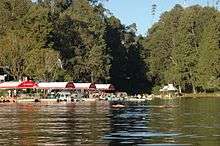 Ooty Lake
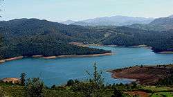 Emerald Lake
 Houses at Ooty
See also
- Badaga Language
- Badagas
- Coonoor
- Devala, India
- Forest Dale, The Nilgiris
- John Sullivan (British governor)
- Kotagiri
- Kota language
- Kotas
- Mango Orange
- Nilgiri Mountains
- Toda Language
- Toda People
- Udagamandalam
References
- 1 2 3 "2011 Census of India" (Excel). Indian government. 16 April 2011.
- ↑ Hockings, Paul (2013). So Long a Saga: Four Centuries of Badaga Social History. New Delhi: Manohar. pp. 51–67. ISBN 978-93-5098-018-7.
- ↑ Hockings, Paul (1996). Bibliographie générale sur les monts Nilgiri de l'Inde du sud 1603-1996. Bordeaux: Dymset. ISBN 2-906621-27-7.
- ↑ Hockings, Paul (2013), So Long a Saga: Four centuries of Badaga Social history, New Delhi: Manohar, pp. 13–29
- ↑ Paul Hockings, ed. (2012). "Fenicio, Giacomo, S.J.". Encyclopaedia of the Nilgiri Hills. New Delhi: Manohar. pp. 314–321. ISBN 978-81-7304-893-7.
- ↑ Hockings, Paul (2012). "History". Encyclopaedia of the Nilgiri Hills. New Delhi: Manohar. p. 422.
- ↑ Hockings, Paul, ed. (2012). "Whish, John Clinton, and Nathaniel William Kindersley". Encyclopaedia of the Nilgiri Hills. New Delhi: Manohar. pp. 989, 991.
- ↑ Hockings, Paul, ed. (2012), "Sullivan, John", Encyclopaedia of the Nilgiri Hills, New Delhi: Manohar, pp. 881–888
- ↑ Mulley, Philip K. (2012). "Cockburn Family". In Paul Hockings. Encyclopaedia of the Nilgiri Hills. New Delhi: Manohar. pp. 213–214.
- ↑ Noble, William, & Paul Hockings (2012). "Nilgiri Hills". In Paul Hockings. Encyclopaedia of the Nilgiri Hills. New Delhi: Manohar. pp. 646–648.
- ↑ Noble, William A. (2012). "Climate". In Paul Hockings. Encyclopaedia of the Nilgiri Hills. New Delhi: Manohar. pp. 208–211.
- ↑ Hockings, Paul, ed. (2012). "Chisholm, Robert Fellowes". Encyclopaedia of the Nilgiri Hills. New Delhi: Manohar. pp. 189–190.
- ↑ "Home: District of The Nilgiris, Tamilnadu, India".
- 1 2 "Census Info 2011 Final population totals". Office of The Registrar General and Census Commissioner, Ministry of Home Affairs, Government of India. 2013. Retrieved 26 January 2014.
- ↑ Rivers, W.H.R. (1906). The Todas. London: Macmillan.Walker, Anthony R. (1986). The Toda of South India: a new look. New Delhi: Hindustan Publishing. Wolf, Richard K. (2005). The Black Cow's Footprint. Delhi: Urbana: University of Illinois Press. ISBN 81-7824-126-9.
- ↑ Hockings, Paul (2013), So Long a Saga: Four Centuries of Badaga Social History, New Delhi: Manohar
- ↑ http://www.census.tn.nic.in/religion.aspx. Missing or empty
|title=(help) - ↑ Hockings, Paul (2012), "Ghat Roads", Encyclopaedia of the Nilgiri Hills, New Delhi: Manohar, pp. 383–387
- ↑ Hockings, Paul (2012). "Railway". Encyclopaedia of the Nilgiri Hills. New Delhi: Manohar. p. 751.
- ↑ "Mountain Railways of India". UNESCO. Retrieved 26 January 2014.
- ↑ Welcome to Nilgiris
- ↑ Muthiah, S. (2012). "Tea". In Paul Hockings. Encyclopaedia of the Nilgiri Hills. New Delhi: Manohar. pp. 895–899.
- ↑ Davidar, Priya & Deborah Sutton (2012). "Sholas". In Paul Hockings. Encyclopaedia of the Nilgiri Hills. New Delhi: Manohar. pp. 818–821.
- ↑ Krishnan, Siddharth & Paul Hockings (2012). "Tourism". In Paul Hockings. Encyclopaedia of the Nilgiri Hills. New Delhi: Manohar. pp. 955–959.
External links
| Wikimedia Commons has media related to The Nilgiris District. |
- The Nilgiris District
- The Chinese, Tea and the Nilgiris
- Making of Wanton soup in Nilgiris
- Chindians of Nilgiris
- Chinese Connection and Nilgiris Tourism
- Indian History Carnival–60: 5th Anniversary Edition
| District Headquarters | 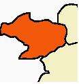 | |
|---|---|---|
| State | ||
| Divisions | ||
| Taluks | ||
| Revenue blocks | ||
| Indigenous Tribes | ||
| Tallest Peaks | ||
| Places of interest | ||
| ||
| State symbols |
|
|---|---|
| Governance |
|
| Topics | |
| Districts |
|
| Major cities | |