Vikramasingapuram
| Vikramasingapuram VK Puram | |
|---|---|
| Town | |
| Nickname(s): Singai | |
 Vikramasingapuram Location in Tamil Nadu, India | |
| Coordinates: 8°40′N 77°20′E / 8.67°N 77.33°ECoordinates: 8°40′N 77°20′E / 8.67°N 77.33°E | |
| Country |
|
| State | Tamil Nadu |
| District | Tirunelveli |
| Government | |
| • Type | Second Grade Municipality |
| • Body | Vikramasingapuram Municipality |
| Elevation | 200 m (700 ft) |
| Population (2011)[1] | |
| • Total | 47,241 |
| Languages | |
| • Official | Tamil |
| Time zone | IST (UTC+5:30) |
| PIN | 627425 |
| Vehicle registration | TN-76 |
Vickramasingapuram or V.K.Puram is a Municipal town in Tirunelveli District in the Indian state of Tamil Nadu. It falls under the Ambasamudram Taluk. As of 2011, the town had a population of 47,241.
It is situated on the banks of river Thaamirabarani, 46 km from Tirunelveli, the capital of the District. This place is at the southernmost end of the Western Ghats which is called as "Podhigai Hill". Various religions' and castes' people are residing peacefully here.
It is close to the Agasthiyar Falls, on the banks of the Thamirabarani river.The falls has significant flow throughout the year unlike the seasonal Kutralam falls.
Nearby Places of Vickramasingapuram
Karaiyar Dam is located 49 km from Tirunelveli. This is a beautiful picnic spot. The natural beauty of Papanasam a place, 38 km west of Tirunelveli is enhanced by the Agasthiyar falls by which the Tamirabarani river descends into the plains. The water drops from a height of 100m over a wall of rock, covered both sides by forested hills of the Western Ghats. The water here is believed by Hindu Devotees to wash away all sins and there is a legend that close to the falls, on the banks of the Tamiraparani river Siva and Parvati appeared before Agasthiyar. The Papavinaswehwara temple is situated near the waterfall.
The temple in Agasthiyar falls which is one of the oldest temple in the history and the believes says that still some saints( sitthars) are available in the temple. Lord Shiva will be very powerful on Full Moon Day and No Moon Day.
Manimuthar falls and Manimuthar dam is another exotic beauty also nearby.
Geography
Vikramasingapuram is located at 8°40′N 77°20′E / 8.67°N 77.33°E.[2] It has an average elevation of 200 metres (656 feet). It is situated 53 km to the south of Tirunelveli and 7 km from Ambasamudram. It is situated on the banks of river Thamirabarani
More information on Vickramasingapuram can be found at the Municipality Website [3]
Demographics
According to 2011 census, Vikramasingapuram had a population of 47,241 with a sex-ratio of 1,058 females for every 1,000 males, much above the national average of 929.[4] A total of 4,198 were under the age of six, constituting 2,053 males and 2,145 females. Scheduled Castes and Scheduled Tribes accounted for 8.11% and 1.14% of the population respectively. The average literacy of the town was 81.28%, compared to the national average of 72.99%.[4] The town had a total of 13558 households. There were a total of 19,811 workers, comprising 242 cultivators, 862 main agricultural labourers, 2,915 in house hold industries, 13,366 other workers, 2,426 marginal workers, 13 marginal cultivators, 413 marginal agricultural labourers, 549 marginal workers in household industries and 1,451 other marginal workers.[5]
As per the religious census of 2011, Vikramasingapuram had 78.62% Hindus, 7.45% Muslims, 13.83% Christians, 0.02% Sikhs, 0.02% Buddhists and 0.05% following other religions.[6]
Occupation
The town is surrounded by green paddy fields. Agriculture is the primary business in this area before 1940. Till few years back, majority of the population were employed in Madura coats, a Textile mill which is on the foothills of the Western Ghats near Papanasam. However now the number has reduced due to downsizing.
This town is also well known for its schools. These include St.Mary's Higher Secondary School, [Papanasam Labour Welfare Association Higher Secondary School], [Amali Girls Higher Secondary School] and Senaithalaivar Higher Secondary School.
Tourist attractions
Kalakkad Mundanthurai Tiger Sanctuary (2 km), Papanasam Dam (Karaiyar) (17 km), kalyaniTheertham Falls (20 km), Servalar Dam(15 km), Agasthiyar Falls(4 km), Papanasam Sivan Temple (2 km), Manimuthaar Dam & Falls (20 km), Manjolai Tea Estate (35 km), Kothaiyaar Dam(55 km), Kadananathi Dam(20 km), Courtallam Falls (35 km)
Located between elevations ranging from 1000 to 1500 Metres, the Manjolai area is set deep within the Western Ghats within the Kalakad Mundanthurai Tiger Reserve in the Tirunelveli District. Located on top of the Manimuthar Dam & the Manimuthar Water Falls, the Manjolai area comprises Tea Plantations, Small settlements around the tea plantations; Upper Kodaiyar Dam and a windy view point called Kuthiravetti
The Tea Plantations and the whole of Manjolai Estates are tea operated by The Bombay Burmah Trading Corporation Ltd on Forest Lands leased by the Government of Tamil Nadu. There are 3 Tea Estates within the Manjolai area - Manjolai Estate, Manimutharu Estate & Oothu Estate. The Estates are located on elevations ranging between 2300 Feet to 4200 Feet. The estates, road & the settlements in the Manjolai area are managed by The Bombay Burmah Trading Corporation Ltd.
- Papanasam River (2 kilometres from Vickramasingapuram)
- Agasthiar Falls
- KalyaniTheertham Falls
- Papanasam (Lower) Dam
- Papanasam (Upper) Kaarayaar Dam
- Servalar Dam
- Manimutthaar Dam
- ThaiCines - Movie Theatre (Thaai means 'Mother') (The largest movie hall of the whole district, capable of 1830 viewers)
- Kalakkad Mundanthurai Tiger Reserve [7]
Click the image below to view the full images
 Agasthiar falls (Kalyani theertham)
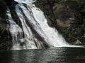 Vaana theertham falls (which flows into the Karayar dam)
 Papanasam temple (November 2007)
 Vaana theertham falls (November 2007)
References
- ↑ http://www.censusindia.gov.in/pca/SearchDetails.aspx?Id=702194
- ↑ Falling Rain Genomics, Inc - Vikramasingapuram
- ↑ Welcome to Vickramasingapuram Municipality Archived April 2, 2008, at the Wayback Machine.
- 1 2 "Census Info 2011 Final population totals". Office of The Registrar General and Census Commissioner, Ministry of Home Affairs, Government of India. 2013. Retrieved 26 January 2014.
- ↑ "Census Info 2011 Final population totals - Vikramasingapuram". Office of The Registrar General and Census Commissioner, Ministry of Home Affairs, Government of India. 2013. Retrieved 26 January 2014.
- ↑ "Population By Religious Community - Tamil Nadu" (XLS). Office of The Registrar General and Census Commissioner, Ministry of Home Affairs, Government of India. 2011. Retrieved 13 September 2015.
- ↑ Tourism information from Nellai website
| State symbols |
|
|---|---|
| Governance |
|
| Topics | |
| Districts |
|
| Major cities | |
Boating spot at Karayar dam with safeguard