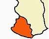
Kanyakumari district
| Kanyakumari District கன்னியாகுமரி மாவட்டம் Kumari Mavattam | |
|---|---|
| District | |
|
| |
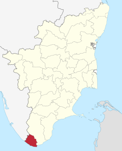 Location in Tamilnadu,India | |
| Coordinates: 8°04′41″N 77°32′28″E / 8.078°N 77.541°ECoordinates: 8°04′41″N 77°32′28″E / 8.078°N 77.541°E | |
| Country |
|
| State | Tamil Nadu |
| District | Kanyakumari |
| Established | 1 November 1956 |
| Headquarters | Nagercoil |
| Talukas | Agastheeswaram, Kallkkulam, Thovalai, Vilavancode |
| Government | |
| • Collector & District Magistrate | Mr. SajjanSingh R Chavan. IAS |
| • Superintendent of Police | G. Dharmarajan IPS |
| • Asst. Supdt. of Police, Thuckalay | M. Sree Abhinav IPS |
| Area | |
| • Total | 1,684 km2 (650 sq mi) |
| Population (2011) | |
| • Total | 1,870,374 |
| • Density | 1,110.7/km2 (2,877/sq mi) |
| Languages | |
| • Official | Tamil |
| Time zone | IST (UTC+5:30) |
| PIN | 629 xxx |
| Telephone code | 04652 & 04651 |
| Vehicle registration | TN-74 & TN-75 |
| Coastline | 72 kilometres (45 mi) |
| Sex ratio | M-1000/F-1014 ♂/♀ |
| Literacy | 97.6% |
| Legislature type | Elected |
| Legislature Strength | 6 |
| Lok Sabha constituency | Kanyakumari |
| Vidhan Sabha constituency | 6 |
| Precipitation | 1,865 millimetres (73.4 in) |
| Avg. summer temperature | 23 °C (73 °F) |
| Avg. winter temperature | 11 °C (52 °F) |
| Central location: | 8°03′N 77°15′E / 8.050°N 77.250°E |
| Website |
www |
Kanyakumari district is the southernmost district in Tamil Nadu state and mainland India. It is the second largest district in the state in terms of population density and the second most urbanized, next only to Chennai district.[1] The district stands first in terms of literacy rate in the state. The district headquarters is Nagercoil.
Kanyakumari district has a varied topography with sea on three sides and the mountains of the Western Ghats bordering the northern side. Geologically, the landmass of the district is much younger when compared to the rest of state - faulted as late as 2.5 millon years during the Miocene, after which numerous transgression as well as regression of sea had shaped the western coast of the district.
Historically, Nanjinad and Eda Nadu which comprise the present Kanyakumari district, were ruled by various Tamil and Malayalam dynasties: the Venad Kingdom, Pandyans, the Cheras, the Cholas, the Ays and the Nayaks. A few artifacts unearthed by archeological excavations in there.It was part of the princely state of Travancore during the colonial times prior to India's independence; four of the eight tehsils of Thiruvananthapuram district were separated to form the new district of Kanyakumari during the formation of the new state of Kerala, and they were made a part of the Madras Presidency under recommendations from the States Reorganisation Commission in 1956. The Presidency was later renamed Tamil Nadu and Kanyakumari, today, is one of the 32 districts of Tamil Nadu state.
Many historical assumptions persist in the district and state, which associate sages such as Vyasa, Agastya, Tolkappiyar, Avvaiyar and Thiruvalluvar to the district. The district is also the birthplace of Ayyavazhi.
History
The area that comprises the current Kanyakumari district was a part of the old Ay kingdom of the first and second Sangham ages. Following the decline of the Ay kingdoms, the area became Venad, with its capital Padmanabhapuram located north of Nagercoil. The wealth of the Nanjalnadu beckoned many invaded including the Nayaks and later an Islamist army during the reign of Umayamma Rani. The Venad region was in anarchy before Marthanda Varma ascended the throne in 1729 AD. Before his reign the Samanthan Nairs ruled the province. Under their rule anarchy was dominant in Kanyakumari region. However, Marthanda Varma brought a sense of disorder under control by annexing the nearby territories, putting down the feudal lords and establishing the strong state of Travancore. He had also bought some portions of Kanyakumari from the then viceroy making it the southern boundary. Under his rule the district improved in a social context as well as economically. The famous battle of Colachel took place in the district. Later, the maharajahs of Travancore built the forts at Aramboly to prevent any invasion from the Carnatic. Key elements of Velu Thampi Dalawa's revolt occurred in the area and the English East India company's army under Col. Leger broke through the fortifications and entered Travancore in 1810. In the year 1949, the area became a part of the reestablished Travancore Cochin state. The people of Agasteeswarem, Thovalai, Kalkulam and Vilavancode taluks, which formed the southern divisions of the former district of Trivandrum, were predominantly Tamil speaking people. , an extreme agitation by Tamil speaking residents under the leadership of Marshal Nesamony, took place for including Kanyakumari within Tamil Nadu. Eventually the merger happened in 1956 based on language reorganization of states.
Location
The district of Kanyakumari is the southern most districts in the state of Tamil Nadu. It is situated between 77°15' and 77°36' east latitude and 8°03' and 8°35' north longitude. The district has borders with Tirunelveli district, the Gulf of Mannar, the Indian Ocean, the Arabian Sea and the state of Kerala.
Administrative divisions
For administrative purposes, the district comprises four taluks: Thovalai, Agastheeswaram, Kalkulam, and Vilavancode. It has nine blocks — Agastheeswaram, Rajakkamangalam, Thovalai, Kurunthancode, Thuckalay, Eraniel, Thiruvattar, Killiyur, Munchirai and Melpuram — and four municipalities: Nagercoil, Padmanabhapuram, Colachel and Kuzhithurai.
At the lower levels of administration, there are 99 village panchayats and a further 56 special category village panchayats.
The major towns of the district include:
- Agastheeswaram taluk: Nagercoil, Kanyakumari, Agastheeswaram, Suchindram and Rajakkamangalam.
- Thovalai taluk: Thovalai and Boothapandi.
- Kalkulam taluk: Padmanabhapuram-Thuckalay, Colachel, Kalkulam, Thiruvithamcode, Kurunthancode, Thiruvattar and Kulasekaram, ThingalNager.
- Vilavancode Taluk: Karungal, Kuzhithurai-Marthandam, Vilavancode, Killiyur, Munchirai,Manjalumoodu Arumanai and Melpuram.
Demography
According to 2011 census, Kanniyakumari district had a population of 1,870,374 with a sex-ratio of 1,019 females for every 1,000 males, much above the national average of 929.[2] A total of 182,350 were under the age of six, constituting 92,835 males and 89,515 females. Scheduled Castes and Scheduled Tribes accounted for 3.97% and .39% of the population respectively. The district had a total of 483,539 households. There were a total of 679,620 workers, comprising 12,229 cultivators, 51,350 main agricultural labourers, 21,078 in house hold industries, 468,001 other workers, 126,962 marginal workers, 3,381 marginal cultivators, 21,517 marginal agricultural labourers, 14,711 marginal workers in household industries and 87,353 other marginal workers.[3]
Average literacy rate of Kanyakumari in 2011 were 91.75 compared to 87.55 of 2001. If things are looked out at gender wise, male and female literacy were 93.65 and 89.90 respectively. For 2001 census, same figures stood at 90.37 and 84.79 in Kanyakumari District. Total literate in Kanyakumari District were 1,548,738 of which male and female were 780,541 and 768,197 respectively. In 2001, Kanyakumari District had 1,308,322 in its district.
Urban Population
Out of the total Kanyakumari population for 2011 census, 82.33 percent lives in urban regions of district. In total 1,539,802 people lives in urban areas of which males are 761,407 and females are 778,395. Sex ratio in urban region of Kanyakumari district is 1022 as per 2011 census data. Similarly child sex ratio in Kanyakumari district was 966 in 2011 census. Child population (0-6) in urban region was 148,570 of which males and females were 75,573 and 72,997. This child population figure of Kanyakumari district is 9.93% of total urban population. Average literacy rate in Kanyakumari district as per census 2011 is 91.96% of which males and females are 93.92% and 90.06% literates respectively. In actual number 1,279,358 people are literate in urban region of which males and females are 644,109 and 635,249 respectively.
Rural Population
As per 2011 census, 17.67% population of Kanyakumari districts lives in rural areas of villages. The total Kanyakumari district population living in rural areas is 330,572 of which males and females are 164,938 and 165,634 respectively. In rural areas of Kanyakumari district, sex ratio is 1004 females per 1000 males. If child sex ratio data of Kanyakumari district is considered, figure is 957 girls per 1000 boys. Child population in the age 0-6 is 33,780 in rural areas of which males were 17,262 and females were 16,518. The child population comprises 10.47% of total rural population of Kanyakumari district. Literacy rate in rural areas of Kanyakumari district is 90.76% as per census data 2011. Gender wise, male and female literacy stood at 92.39 and 89.16 percent respectively. In total, 269,380 people were literate of which males and females were 136,432 and 132,948 respectively.
Religion
During 2011, total population of the district is 1,870,374, among them 909,872 (49%) are Hindus, 876,299 (46.85%) are Christians, 78,590 (4.2%) are Muslims, 438 (0.02%) are Buddhists, 160 (0.01%) are Sikhs, 156 (0.01%) are Jains, 10 (0.001%) are Others and 4,849 (0.26%) are none of the above.[4]

Festivals
The Mandaikadu festival is celebrated in March by people of the district and by those in Kerala. Traditionally, participants would chant while walking and other people would provide them with butter, milk, water, jaggery, and coffee. The festival, which is celebrated for ten days, later became a social function, especially on Sunday.[6] In 1982 there were police shootings to quell a disturbance by anti-social religious radicals. Today, Mandaikadu is more of a departmental festival.
Navarathri Pooja celebrations: During Navarathri Pooja, Annai Adi Parasakthi (the divine mother of Lord Muruga) leave Sushintharam temple situate in Nagercoil, and perform a yatra in Pallakku to Trivandrum, the headquarters of the Kerala State, to participate in the Navarathiri Pooja celebrations at the Devi Koil in the vicinity of the Trivandrum Palace. Lord Muruga from Kumarakoil also accompany Annai in a procession, riding a horse. This practice has been in vogue since 1840 when the rulers of the erstwhile Trivancore Samasthanam (province) changed their headquarters from Padmanabhapuram in Thuckalay to Trivandrum. This practice exemplifies the strong connection between the erstwhile Malai Nattu (kerala) rulers and Kumarakoil.
The kootalmoodu festival is celebrated for ten days. In the 10th day festival ends with grand fire works "vana vedikai" which starts in mid-night and ends at early morning. The great Shivrathiri festival is famous in this district. The devotees will run to 12 shiva temple situated in all around district.
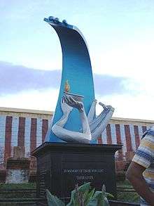
The Ayya vaikunda Avataram, is widely celebrated throughout the district.[7][8] The Kodiyettru Thirunal is celebrated in the religious headquarters of Swamithope pathi and attracts large crowds[9] from Tamil Nadu and across India.[10][11][12]
Besides Deepavali, Christmas is also celebrated in kanyakumari due to the large number of Christians. On the eve of Christmas, carol services visit the families and sing songs all night. The carol services usually travel in decorated trucks.
New Year is celebrated with Vana Vediakkai (fireworks) and local games such as Valukku Panai (slippery palm), a game in which a person has to climb an Areca palm that is flooded with oil.
Food
The main source of food is coming from rice and rice products. Those are may be used to make dosa, idily, appam and puttu, etc.,.
Rice is the staple food of the people, although for some people in the hilly areas, tapioca is the main food. Though there are some vegetarians among the populace, a majority of the people use agro, meat and fish products. Fish caught in the seas around the district during the night or early morning hours reach the markets in the interior towns and villages in the early morning. Also they prepare a coffee made by karuppatti during the winter season. The food (for example, Chakkoli) is spicy, and the people in the district tend to use more grated coconut in their curries and food-preparations.
Transport and highways
There are two major National Highways (NH) roads emanating from Kanyakumari town. One is the NH 7 that starts from the town and runs through Madurai and the other is the NH 47 that runs to Salem through Kerala, touching some important cities like Trivandrum, Kochi and Coimbatore.
The state-owned Tamil Nadu State Transport Corporation is the major operator of bus services in the district, though licences are issued for specific routes to private operators.KSRTC also operates frequent services to Nagarcoil and Kanyakumari from Trivandrum.
Today, there are 3495.80 km of surfaced roads in the district.
Indian Railway operates train from Kanyakumari District to many important places of India.
There is a proposal to build an airport in Nagercoil by Airports Authority of India.
Education
Colleges of higher education are found throughout the district, mainly art, science and engineering colleges. The Scott Christian College, founded by William Tobias Ringeltaube in Nagercoil, is more than 100 years old.[13]
The state runs the Kanyakumari Government Medical College at Asaripallam, a Government Engineering College and a Government Polytechnic at Konam, near Nagercoil. Many private Engineering Colleges including a private university were started-functioning in the recent past. No fewer than 30 engineering colleges are functioning in the district which are currently affiliated to the Anna University; arts and science colleges are affiliated to Manonmaniam Sundaranar University, Tirunelveli. The Manonmaniam Sundaranar University runs a research unit — Centre for Marine Sciences and Technology — at Rajakamangalam, Kanyakumari District. Noorul Islam University is the only private university functioning at Thuckalay.Education changed the cultural,economic,social,scenario of the district and dramatically differentiate it from other districts.kanyakumari district people occupy top level state & central Government postings and earned good reputations among colleagues. the S.T. Hindu College is also one of the oldest colleges in nagercoil.
Rivers
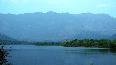
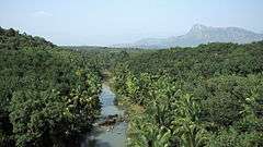
The major river in the district is Thamirabarani locally known as Kuzhithuraiar. This river has two major tributaries, Kodayar and Paralayar, with the Pechiparai Dam and Perunchani Dam, respectively, built across them. There are many tributaries for the Kodayar River of which Chittar I and Chittar II, with their dams, are the major ones. The origin of Tambaraparani River is in the Western Ghats and the river confluences with Laccadive Sea near Thengapattanam, about 56 kilometres (35 mi) west of Kanyakumari town.
Valliar, another small river, along with its tributary Thoovalar, originates from the Velimalai Hills, collects drainage from P.P. Channel and its branches, ayacuts (irrigated area under a tank) and confluences with the Laccadive Sea in Kadiapattinam.
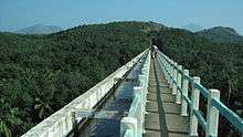
The Pazhayar River, another small river, starts at Shorlacode, about 18 kilometres (11 mi) north-west of Nagercoil. This is polluted as it collects drainage of Thovalai, Ananthanar and Nanjil nadu puthanar channel passing through Thazhakudi,Vellamadam villages. The Pahrali River also flows through the district. The Mathur Hanging Trough, the highest and longest aqueduct in Asia, was built over it near Mathur.
Forests
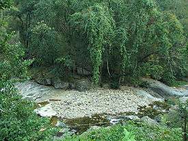
The forests in Kanyakumari District are about 75 million years old. Of the total district area of 1671.3 km2, government forests occupy an area of 504.86 km2 which comes to about 30.2 percent of the geographical area of the district.[14] The forests of the district are administered through the Kanyakumari Forest Division, with headquarters at Nagercoil, the capital of Kanyakumari District.
There are 14 types of forests from luxuriant tropical wet evergreen to tropical thorn forests. This variety occurs in the district because of diverse locality factors.[15] Rainfall varies from 103 cm to 310 cm elevation from sea level to 1829 m. The forest area is 30.2% of the total district geographical area which is next to Nilgiris district with 59% and Dharmapuri District with 38% in Tamil Nadu State. 52% of the district's forests are classified as dense forests, which is second only to Dharmapuri District with 58%. The forests contain species such as Mesua ferrea, Bischofia Javanica, Vitex altissima to smaller trees of Dillini a species festooning climber, shrubs, valuable herbs, variety of orchids, two types of canes, many indigenous palms and cycas. The important timbers are teak, rosewood, vengai and aini. Various types of forest products like bamboos, reeds, canes, soft wood, tamarind, lemon grass, rubber, coconut, arecanut, terminalia chebula, cinnamon bark nelli, cardamom, mango and many medicinal plants are harvested in this district. The Maruthuvalmalai, a hill located among green paddy fields and coconut palms, is famous for valuable medicinal plants. This is the only district in Tamil Nadu where rubber and clove plantations have been raised in reserve forests in an area of 47.857 km2 and 1.1 km2 respectively. The district is rich in wildlife with at least 25 types of mammals, about 60 species of birds including 14 species of migratory birds and many species of fishes, reptiles and amphibians listed.
The following are the reserve forests in Kanyakumari Forest Division:
- Therkumalai East and West - 17.4 km2
- Thadagaimalai - 7.9 km2
- Poigaimalai - 12.4 km2
- Mahendragiri - 43.6 km2
- Veerapuli - 281.9 km2
- Velimalai - 11.2 km2
- Old Kulasekaram - 6.9 km2
- Kilamalai - 81.06 km2
- Asambu - 43.10 km2
Flora and fauna
Fauna
The flora and fauna of Kanyakumari District are vast and diverse.
Animals on the hills of the district include Bengal tiger, elephant, sambar deer, porcupines, hedgehogs and wild boar, while pied kingfisher, painted stork and cranes are commonly found in the water bodies and wetlands. Reptiles include monitor lizards, pythons, blood viper and other snakes.
In Mahendragiri hills (about 4,000 ft (1,200 m) above sea level), one can find elephant, tiger, leopards and deer. Leopard cubs often stray onto the highway near the hills and are sometimes run over by motorists.
The Keeriparai and Maramalai hills are habitats for wild elephants and Indian bison. The Kodayar hills are the breeding centers for the Indian rock pythons and Indian bison. In the Theroor wetlands, one can see several varieties of storks and migratory birds during specific seasons. Trout and other varieties of freshwater fish are found in the Pechiparai reservoir.
The district also has a wildlife sanctuary and a bird sanctuary[16]
Flora
Kanyakumari district is noted for its medicinal plants and herbs. The district also has a huge forest cover, accommodating a wide variety of plants, trees, and shrubs.
Commercial varieties include various kinds of plantain (like Nenthiram, Palayamkotan, Thuluvam, Matti,"Singan", "Robesta", "Rasathali" ), jackfruit (like Varikila , "Semparthi Varikila" and Koolan), mango (varieties like Alphonsa, Bangalora, Neelam , "Sunnakannan", Senga Varikka" and Ottu) and coconut. In addition to fruits, a variety of flowers like roses and jasmine are also produced. Common garden varieties in the district include crotons, lilies, and dahlias.
Areas like Keeriparai are home to varieties of ferns, bamboos and other tropical plants. Flame of the forest (Butea monosperma), a tree with reddish and orange leaves and flowers, is found in the Pechiparai Reservoir. Rubber estates are found in the hilly areas surrounding Arumanai, Kaliyal, and Kadayal.
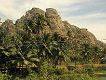
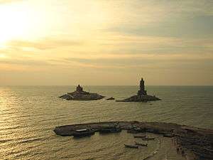
Tourist attractions
Kanyakumari district has various eco-systems, including beaches, mountain valleys and evergreen forests, as well as rubber and clove plantations
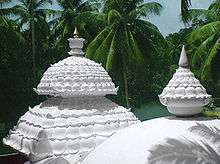
- The Padmanabhapuram Palace complex is located in the granite Padmanabhapuram Fort, close to Thuckalay and at the foot of the Veli Hills, which form a part of the Western Ghats. The river Valli flows nearby.[17]

- Vattakottai Fort (literally, "circular fort") is an 18th-century fort overlooking the sea, located six kilometres from Kanyakumari.
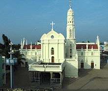
- St. Xavier's Church, Kottar, Cathedral of the Roman Catholic diocese of Kottar, where St. Francis Xavier celebrated Mass in the 16th century.
- Bawa Kassim Valiyullah Masjid, Elankadai, This is one of the famous Mosques of Kanyakumari District. Located in Elankadai (Edalakudy), Nagercoil.
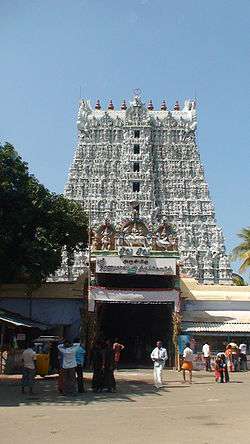
- Suchindram has the Sthanumalayan temple with a repository of art treasures belonging to several kingdoms. The temple is famous for its ninth-century inscriptions, musical columns, and 6-meter-tall statue of Hanuman. The main deity in the form of a shivlinga represents Shiva, Vishnu, and Brahma, the trinity of the Hindu pantheon.
- The Panchappathi, five primary sacred places of Ayyavazhi are all situated within a fifteen-kilometre radius of Kanyakumari. It also includes the Swamithope Pathi (headquarters of Ayyavazhi), a famous temple in Tamil Nadu, situated ten kilometres to the northwest. It is not structurally massive temple, but is known for its non-idolatry system of worship.
- Thiruvithamcode Arappally or Thomaiyar Kovil as named by the then Chera king Udayancheral, is located at Thiruvithancode in Kanyakumari District of Tamil Nadu, India. It is now declared an international St. Thomas pilgrim center.The world's oldest existing church structure, which was believed to be built by Thomas the Apostle in 57 AD
- Udayagiri Fort, built by King Marthanda Varma, has a foundry for casting guns. It is also the tomb-site of the king's trusted European general Captain De Lennoy. Udayagiri Fort is now a bio-diversity park, administered by the Department of Forests, Kanyakumari Division.
- Mathur Hanging Trough, near Thiruvattar in the District, is an aqueduct that carries irrigation water through a canal between two hills. The canal itself goes above a small river. Built on very high pillars, is one of the biggest aqueducts, both in height and length, in Asia. The view from the middle of the aqueduct of the surrounding hills and vegetation, and the small river flowing down below, is breathtaking.
- The Chitharal Jain Monuments, situated about 35 km (22 mi) from Marthandam, are rock shelters and idols dating from the 9th- to 11th-centuries.
- Olakaruvi waterfalls, about 20 km (12 mi) from Nagercoil is on the middle of a hill and requires an hour's trek by foot from the base of the hill (better to go in a group, as it is a forested area)
- Pechiparai Reservoir, about 30 km (19 mi) from the town, and also Perunchani and Chittar dams.
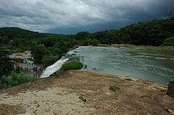
- Thiruparrapu Falls, is a waterfall near Thiruparrapu. There is an ancient temple near the falls, which is popular among the locals and Keralites.
- Sanguthurai Beach, about 8 km (5.0 mi) from Nagercoil is a palm-fringed and sandy beach. Sothavilai Beach is another good beach, about 7 km (4.3 mi)from the heart of town. Both beaches were hit by the Indian Ocean Tsunami, but authorities have taken steps to improve facilities again. There is a lagoon at Manakudy – 10 km (6 mi) from the town.
- Old Eraniel Palace it is believed that it was built during the reign of king Vanchi Marthanda Varma of the Venad dynasty about 500 years ago. The palace functioned as an administrative hub of the Venad kings until king Ravi Varma Kulashekhara shifted the seat of power to Padmanabhapuram after constructing a palace there in 1601.
- Mukkudal reservoir : Fresh water supply to Nagercoil is from the Mukkadal Reservoir, about 8 km (5.0 mi) from the town, in the interior – itself a scenic place, with a small bushy island in the middle of the dam. The dam is surrounded by hills of the Western Ghats.
- Kalikesam,- is a scenic picnic spot. The Kali temple situated here attracts many pilgrims.
- Maruthuvazhmalai or (Marunthuvazh Malai)
- Thangaipattinam Polzhi
- Thuckalay Peerappa Dargha
- Edappad Beach(near Kerala border)
- Kollencode Thooka mudupera Temple:-It is very famous for "thookam nercha". During march-April season, Thousands of people comes to worship here.
- Neerodi to Erayumanthurai also known as "The Eight Villages"is famous for fishing. People of these villages live very peacefully with unity.
Indian Ocean tsunami
Kanyakumari district was one of the worst affected districts in India in the tsunami that ravaged the coasts of various countries in South and South East Asia, on 26 December 2004. There were nearly 900 deaths and several hundreds missing and injured. Social organizations from several countries and the Government have since been working on rehabilitating the affected people and property.
See also
References
| Wikimedia Commons has media related to Kanyakumari district. |
- ↑ Kumari second most urbanised TN district - South India - Tamil Nadu - ibnlive
- ↑ "Census Info 2011 Final population totals". Office of The Registrar General and Census Commissioner, Ministry of Home Affairs, Government of India. 2013. Retrieved 26 January 2014.
- ↑ "Census Info 2011 Final population totals - Kanniyakumari district". Office of The Registrar General and Census Commissioner, Ministry of Home Affairs, Government of India. 2013. Retrieved 26 January 2014.
- ↑ http://www.census2011.co.in/census/district/51-kanniyakumari.html
- ↑ "Population by religion community – 2011". Census of India, 2011. The Registrar General & Census Commissioner, India. Archived from the original on 25 August 2015.
- ↑ "Kanyakumari Temple News". news.kanyakumari.com. Retrieved 2016-05-26.
- ↑ The Daily Thanthi, Nagercoil Edition, 5/4/2006.
- ↑ "Dina Malar". Retrieved 2007-02-03.
- ↑ ""Thousands of people witnessed the Vaikasi car festival at Vaikundar temple at Swamithoppu..."". The Hindu. Retrieved 2008-06-03.
- ↑ The Daily Thanthi (Nagercoil Edition), 29-1-2007, Page 12, "Devotees from the districts of Kanyakumari, Tirunelveli, Thoothukkudi, Theni, Chennai, Coimbatore and also from the State of Kerala participated in the Car festival."
- ↑ The Daily Thanthi (Coimbatore Edition), 3-6-2008, Page 4, "Thousands of devotees from the districts of Madurai, Tirunelveli, Thoothukkudi, Theni, Coimbatore and also from the State of Kerala participated in the Car festival."
- ↑ Dinakaran (Tirunelveli Edition), 3-6-2008, Page 6, "Thousands of devotees from the districts of Kanyakumari, Tirunelveli, Thoothukkudi, Theni, and also from the State of Kerala participated in the Car festival."
- ↑ "SCC Nagercoil". Retrieved 10 October 2012.
- ↑ Tamil Nadu Forest Department. Forests.tn.nic.in. Retrieved on 2013-07-28.
- ↑ (according to Champion and Seth's classification)
- ↑ GRUBH, SHAILAJA ROBERT (1 February 2003). "Sanctuary in the lowland plains". The Hindu. Chennai, India. Retrieved 2009-01-08.
- ↑ Padmanabhapuram Palace - Padmanabhapuram Palace Trivandrum Kerala, Padamanabha Puram Palace Thiruvananthapuram India
External links
- Official Website of Kanyakumari district
- Online Yellowpages, Business Directory & Information Portal of Nagercoil & Kanyakumari district
- Kanyakumari district local News
- Vattakottai
- Photographs of the Kanyakumari district
- Tourist places in kanyakumari
 |
Thiruvananthapuram district, Kerala | Tirunelveli district | | |
| |
||||
| ||||
| | ||||
| Lakshadweep Sea | Indian Ocean | Gulf of Mannar |
| State symbols |
|
|---|---|
| Governance |
|
| Topics | |
| Districts |
|
| Major cities | |