Tiruvannamalai district
| Tiruvannamalai District திருவண்ணாமலை மாவட்டம் North Arcot Sambhuvarayar | |
|---|---|
| District | |
|
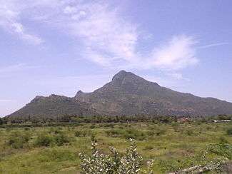
The sacred Arunachala hill, Tiruvannamalai | |
| Nickname(s): Arunai District | |
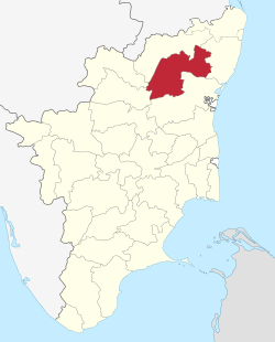 Location in Tamil Nadu, India | |
| Coordinates: 12°25′N 79°7′E / 12.417°N 79.117°ECoordinates: 12°25′N 79°7′E / 12.417°N 79.117°E | |
| Country |
|
| State | Tamil Nadu |
| Region | Tiruvannamalai |
| District | Tiruvannamalai |
| City | Tiruvannamalai |
| Municipalities |
Arni Cheyyar Wandiwash Polur Chengam Chetpet |
| Total Urban areas | 22 |
| North Arcot | 26.1.1989 |
| Founded by | Kalaignar M.Karunanidhi |
| Named for | King Sambhuvarayar |
| Headquarters | Tiruvannamalai |
| Talukas | Tiruvannamalai, Cheyyar, Arani, Chengam, Polur, Vandavasi, Kalasapakkam, Chetpet Thandarampattu and Vembakkam |
| Government | |
| • Body | District collectrate |
| • Collector | Prashant M Wadnere IAS |
| Area | |
| • District | 6,191 km2 (2,390 sq mi) |
| Area rank | 3th rank in Tamil Nadu |
| Population (2011)[1] | |
| • District | 24,64,875 |
| • Rank | 4th rank in Tamil Nadu |
| • Density | 654/km2 (1,690/sq mi) |
| • Metro | 496,343 |
| Time zone | IST (UTC+5:30) |
| ISO 3166 code | [[ISO 3166-2:IN|]] |
| Vehicle registration | TN-25 |
| Coastline | 0 kilometres (0 mi) |
| Largest city | Tiruvannamalai |
| Largest metro | Tiruvannamalai |
| Sex ratio | 1000:994 ♂/♀ |
| Literacy | 79.33% |
| Legislature Strength | 12 |
| Lok Sabha constituency | Arni and Tiruvannamalai |
| Precipitation | 5,646 millimetres (222.3 in) |
| Website |
|
Tiruvannamalai District (also known as Thiruvannaamalai) is one of the 32 districts in the state of Tamil Nadu, in South India. It was formed in the year 1989 from non-existing North Arcot District as Tiruvannamalai Sambuvarayar and Vellore Ambedkar. Tiruvannamalai town is the district headquarters. The district is divided into 12 Taluks - Chengam, Tiruvannamalai, Polur, Thandarampattu, Aarani, Vandavasi, kalasapakkam, chetpet , Cheyyar and vembakkam . Arni is famous for silk sarees. As of 2011, the district had a population of 2,464,875 with a sex-ratio of 994 females for every 1,000 males.
History
Tiruvannamalai is one of the most venerated places in Tamil Nadu. In ancient times, the term "Annamalai" meant an inaccessible mountain. The word "Thiru" was prefixed to signify its greatness, and coupled with the two terms, it was called Thiruvannamalai. Thiru means 'holy' or 'sacred' and is traditionally used in front of names in all parts of Tamil Nadu like Thiruneermalai (Lord Ranganatha), Thirunageswaram (Lord Vishnu and Lord Shiva), Thirumayam (Lord Vishnu and Lord Shiva), Thirumayilai (Lord Adikeshava Perumal and Lord Kapali Eshwaran), Tiruvannamalai (Lord Shiva), Thiruchendur (Lord Muruga), Tiruchirappalli (Lord Sriranganathar), Thiruttani (Lord Muruga), Tiruchengode (Lord Shiva), Thiruchitrambalam (Lord Shiva), Thirumanancheri (Lord Shiva), Thirunallar (Lord Shani Eshwaran), Thiruporur(Lord Muruga), Thirukkadaiyur (Lord Shiva), Tirukalukundram(Lord Vedagiriswarar temple), Thirukarugavur (Lord Garbharakshambigai temple), Tirunelveli, Tiruppur, Tiruvallur and many more.
The temple town of Tiruvannamalai is one of the most ancient heritage sites of India and is a centre of the Saiva religion. The Arunachala hill and its environs have been held in great regard by the Tamils for centuries. The temple is grand in conception and architecture and is rich in tradition, history and festivals. The main Deepam festival attracts devotees from far and wide throughout South India. It has historic places besides Tiruvannamalai, Arni, Vandavasi, Devikapuram connected to East India and French companies. In the late Chola period the district was ruled by the Cholan of Sambuvarayar having Padavedu near Arni as HQ. We can now find the fort and note along with a Shiva temple namely Kailasanathar in Arni town.
After independence Tiruvannamalai was under North Arcot District. The civil district of North Arcot was divided into Vellore District and Tiruvannamalai District in October 1989. Thiru. P.Kolappan IAS was the first Collector of Tiruvannamalai District. On the whole Tiruvannamalai is traditionally rich in Historic and spiritual values but lacks in industrial growth.
Demographics
According to 2011 census, Tiruvannamalai District had a population of 2,464,875 with a sex-ratio of 994 females for every 1,000 males, much above the national average of 929.[2] A total of 272,569 were under the age of six, constituting 141,205 males and 131,364 females. Scheduled Castes and Scheduled Tribes accounted for 22.94% and 3.69% of the population respectively. The average literacy of the district was 66.%, compared to the national average of 72.99%.[2] The district had a total of 588,836 households. There were a total of 1,238,177 workers, comprising 265,183 cultivators, 351,310 main agricultural labourers, 37,020 in house hold industries, 316,559 other workers, 268,105 marginal workers, 27,458 marginal cultivators, 173,753 marginal agricultural labourers, 9,700 marginal workers in household industries and 57,194 other marginal workers.[3]
Tiruvannamalai District has an area of 6,191 km2. It is bounded on the north by Vellore District, on the east by Kanchipuram District, on the south by Villupuram District, and on the west by Dharmapuri and Krishnagiri districts. Tiruvannamalai District is divided into ten taluks, 27 blocks and 1,061 villages covering an area of 631,205 ha. The ten taluks of Tiruvannamalai are listed below:
| Taluk | Headquarters | Area | Population (2011) | Pop density | |
|---|---|---|---|---|---|
| 1 | Polur | Polur | 509 km2 | 328,381 | 645 /km2 |
| 2 | Tiruvannamalai-Urban | Tiruvannamalai | 102 km2 | 345,087 | 3,382 /km2 |
| 4 | Thandarampattu | Thandarampattu | 691 km2 | 410,880 | 593 /km2 |
| 5 | Arni | Arni | 327 km2 | 220,220 | 673 /km2 |
| 6 | Cheyyar | tiruvethipuram | 344 km2 | 200,157 | 618 /km2 |
| 7 | Kalasapakkam | kalasapakkam | 532 km2 | 329,013 | 618 /km2 |
| 8 | savvadhu malai | Jamunamarathoor | 645 km2 | 188,897 | 291 /km2 |
| 9 | Vandavasi | Vandavasi | 645 km2 | 421,174 | 652 /km2 |
| 10 | Chengam | chengam | 510 km2 | 325,993 | 639 /km2 |
| 11 | Chetpet | chetpet | 493 km2 | 290,100 | 588 /km2 |
| 12 | Vembakkam | Vembakkam | 310 km2 | 180,210 | 581 /km2 |
List of cities having population of one lakh and above as per 2011 Census:[4]
| City | Population | City | Population | ||
|---|---|---|---|---|---|
| 1 | Tiruvannamalai | 3,80,543 | 9 | Gandhinagar-Lakshmipuram | 45,571 |
| 2 | Arani | 1,23,783 | 10 | Kalambur | 31,751 |
| 3 | Vandavasi | 1,16,452 | 11 | Vettavalam | 28,059 |
| 4 | Polur | 1,01,420 | 12 | Pudupalayam | 25,374 |
| 5 | Tiruvethipuram | 87,901 | 13 | Thyagi Annamalai Nagar | 24,329 |
| 6 | Chengam | 74,901 | 14 | Peranamallur | 22,619 |
| 7 | Chettupattu | 59,580 | 15 | Adamangalam-Pudur | 21,750 |
| 8 | Kalasapakkam | 46,910 | 16 | Kizh-Pennathur | 21,308 |
The average annual rainfall of the study area is 987 mm, out of which 80 percent is received during monsoon. The soils of the study area have an Ustic moisture regime and Hyperthermic temperature regime. Tiruvannamalai District comes under the Eastern Ghats (TN uplands) and Deccan plateau, hot semiarid region with red loamy soil with cropping period of 90 to 150 days. Excepting hills, the district falls in the North Eastern agro climatic zone of Tamil Nadu. The average annual rainfall of the study area is 987.4 mm, out of which 80 percent is received during monsoon. The soils of the study area have an Ustic moisture regime and Hyperthermic temperature regime.
| Religion | Population | Literacy Rate | Sex Ratio |
|---|---|---|---|
| Hindus | 2,316,962 (62.76%) | 91.88% | 997 |
| Muslims | 1,150,771 (33.09%) | 76.88% | 890 |
| Christians | 77,477 (1.05%) | 78.60% | 1070 |
| Jains, Sikhs and others | 107,107 (1.02%) | 71.23% | 823 |
It is one of the district in Tamil Nadu having highest Muslim population having above 1 million peoples of Muslim.
Economy
In the District Arani and Thiruvannamalai regions are highest revenue generations regions respectievely.
In 2006 the Ministry of Panchayati Raj named Tiruvannamalai one of the country's 250 most backward districts (out of a total of 640).[5] It is one of the six districts in Tamil Nadu currently receiving funds from the Backward Regions Grant Fund Programme (BRGF).[5]
Agriculture
Tiruvannamalai District is known for its two major businesses, agriculture and silk saree weaving. Rice cultivation and processing is one of the biggest businesses in this district. 112013 hectares of paddy cultivation is irrigated by 1965 lakes and 18 reservoirs and small dams. It has 18 regulated markets through which the farmers sell their agri products directly to the government. Through these regulated markets, 271411 metric tonnes of paddy harvested in 2007. There are lot of rice mills to process paddy found throughout the district. The modern rice mill near Cheyyar is the biggest government owned mill and Arani has around 278 rice mills. Kalambur is also has around 20 Rice mills and known for variety of rice called Kalambur Ponni rice.
Silk weaving
The district has a large populace of weavers from Sengunthar caste, who specialize in making Silk sarees. Hand looms are often engaged for weaving, although recently some have turned to mechanized methods of using Power looms. Arni is the most important revenue earning town in the district. Though the town is not popular off the state, a bulk of India's Silk apparels is produced by the people of Arni.
Industrialization
The district started to industrialize following the establishment of the industrial complex near Cheyyar by the State Industries Promotion Corporation of Tamil Nadu (SIPCOT).[6] This is evidenced by the recent announcements of a 250-acre (1.0 km2) hi-tech Special Economic Zone for automative components, a 300-acre (1.2 km2) electronics hardware park and the commitment from the Taiwanese Shoe Company to set up its unit.[7] On Nov, 2009 Tamil Nadu cabinet approved the Mahindara & Mahindra's Rs 1800 core automobile project in 450 acres. This unit will produce tractors, SUVs and commercial vehicles and auto parts.[8] Aluminum die cast unit by Ashley Alteams, a joint venture by Ashok Leyland and Finland-based Alteams Oy started its production on Jan, 2010.[9] This High pressure die cast will manufacture automobile and telecommunication components with initial capacity of 7000 ton per year.[10] One of the largest sugar mills in the country - Cheyyar co-operative sugars - is situated near Cheyyar.
Factories
Since Tiruvannamalai District has its capital at Tiruvannamalai City, there are many factories around Tiruvannamalai. Scent factories are large in number due to the high production of flowers around Tiruvannamalai. They are listed as follows: 1. Hindusthan house hold factories, 2. Sarala birla factory of aroma oil, 3. Parthiban cottages aroma oil factory. The Tamil Nadu government is planning for a SIPCOT at naidumangalam and kilpennathur both near Tiruvannamalai.
Tourism
Sri Seshadri Swamigal Ashram: Mahan Sri Seshadri Swamigal lived in the late 20th century. Sri Seshadri Swamigal Ashram is one of the holy places in Tiruvannamalai. People from all over the world visit this Ashram, which is situated near the Sri Ramana Ashra the people who visit here.
Sri Ramana Ashram: Mahan Sri Ramana Maharshi lived in Tiruvannamalai. Sri Ramana Ashram is one the holy places in this town. People from all over the world visit his Ashram. He attained mukhti in the year 1950.
Yogi Ram Surathkumar Ashram: Yogi Ram Surathkumar Ashram, also known as Visiri Samiyar Ashram, is one of the beautiful place in our Town. It is situated near the Ramana Ashram. Devotees from all over the world visit Yogi Ram Surathkumar Ashram. He attained mukthi in the year of 2000.

Sathanur Dam: Sathanur dam is one of the major dam constructed across Pennaiyar River among Chennakesava Hills. This Dam was constructed during the year 1958. It has beautiful parks and a mini zoo. The garden is dotted with colourful statues. There is a swimming pool
Jawadhu Hills is situated 75 km from Tiruvannamalai. The cliffs and precipices of hills allure and excite tourists. Places of interest in the Jawadhu hills are Beema Falls, Komutteri Lake, Kavalur Observatory, Amirthi Forest, and the Glass House.
Devikapuram is situated 50 km from Tiruvannamalai. Here 600-year-old Sri Periyanayagi amman Temple (Second biggest temple in Tiruvannamalai District) and Sri Kanagagiri Hill temple is famous for devotees all over Tamil Nadu.
Padaved (Padai Veedu), Amman temple and Erikuppam, Sanneeswaran temple near Arani are significant holy places in the district. These places can be visited thru Arani.
Arahanthgiri Jain Math
Arahanthgiri Jain Math is a Jain Math that was established at this ancient Jain site on 8 February 1998, at Thirumalai, Near Arani.[11] The complex includes 3 Jain caves, 4 Jain temples and a 16 meter high sculpture of Neminatha thought to date from the 12th century that is the tallest Jain image in Tamil Nadu.
References
- ↑ "2011 Census of India" (Excel). Indian government. 16 April 2011.
- 1 2 "Census Info 2011 Final population totals". Office of The Registrar General and Census Commissioner, Ministry of Home Affairs, Government of India. 2013. Retrieved 2014-01-26.
- ↑ "Census Info 2011 Final population totals - Tiruvannamalai District". Office of The Registrar General and Census Commissioner, Ministry of Home Affairs, Government of India. 2013. Retrieved 2014-01-26.
- ↑ Census of India 2011: Provisional Population Totals. Cities having population 1 lakh and above.
- 1 2 Ministry of Panchayati Raj (September 8, 2009). "A Note on the Backward Regions Grant Fund Programme" (PDF). National Institute of Rural Development. Retrieved 2011-09-27.
- ↑ "SIPCOT.com website". Retrieved 2008-08-01.
- ↑ "TN setting up electronic hardware park". Business Line. Retrieved 2008-08-01.
- ↑ "TN clears M&M's 1800 cr auto project near Chennai". The Times Of India. 2009-11-12.
- ↑ Jagannathan, K. T. (20 January 2010). "Ashley Atleams plant inaugurated at Cheyyar". The Hindu. Chennai, India.
- ↑ "MACHINIST - Ashley Alteams commissions Rs.130 crore manufacturing facility in Cheyyar". machinist.in. Retrieved 2014-07-12.
- ↑ "Arihantagiri - Tirumalai". Retrieved 2012-04-10.
 |
Krishnagiri District, Bangalore District, Karnataka | Vellore District, Chittor District, Andhra Pradesh | Chennai District | |
| Dharmapuri District | |
Kanchipuram District | ||
| ||||
| | ||||
| salem District, Tamil Nadu | Viluppuram District | Cuddalore District |
| Wikimedia Commons has media related to Tiruvannamalai district. |
| State symbols |
|
|---|---|
| Governance |
|
| Topics | |
| Districts |
|
| Major cities | |