Saint-Sauveur, Finistère
| Saint-Sauveur An Dre-Nevez | ||
|---|---|---|
|
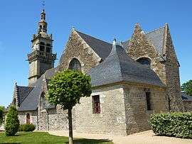
The parish church in Saint-Sauveur | ||
| ||
 Saint-Sauveur | ||
|
Location within Brittany region  Saint-Sauveur | ||
| Coordinates: 48°26′50″N 4°00′16″W / 48.4472°N 4.0044°WCoordinates: 48°26′50″N 4°00′16″W / 48.4472°N 4.0044°W | ||
| Country | France | |
| Region | Brittany | |
| Department | Finistère | |
| Arrondissement | Morlaix | |
| Canton | Sizun | |
| Intercommunality | Pays de Landivisiau | |
| Government | ||
| • Mayor (2014–2020) | Jean-François Kerbrat | |
| Area1 | 13.24 km2 (5.11 sq mi) | |
| Population (2008)2 | 756 | |
| • Density | 57/km2 (150/sq mi) | |
| Time zone | CET (UTC+1) | |
| • Summer (DST) | CEST (UTC+2) | |
| INSEE/Postal code | 29262 / 29400 | |
| Elevation | 86–202 m (282–663 ft) | |
|
1 French Land Register data, which excludes lakes, ponds, glaciers > 1 km² (0.386 sq mi or 247 acres) and river estuaries. 2 Population without double counting: residents of multiple communes (e.g., students and military personnel) only counted once. | ||
.svg.png)
Saint-Sauveur (Breton: An Dre-Nevez) is a commune in the Finistère department of Brittany in north-western France.
Population
Inhabitants of Saint-Sauveur are called in French Salvatoriens.
| Historical population | ||
|---|---|---|
| Year | Pop. | ±% |
| 1793 | 638 | — |
| 1800 | 681 | +6.7% |
| 1806 | 1,251 | +83.7% |
| 1821 | 1,347 | +7.7% |
| 1831 | 1,321 | −1.9% |
| 1836 | 1,395 | +5.6% |
| 1841 | 1,358 | −2.7% |
| 1846 | 1,468 | +8.1% |
| 1851 | 1,488 | +1.4% |
| 1856 | 1,413 | −5.0% |
| 1861 | 1,564 | +10.7% |
| 1866 | 1,505 | −3.8% |
| 1872 | 1,458 | −3.1% |
| 1876 | 1,528 | +4.8% |
| 1881 | 1,464 | −4.2% |
| 1886 | 1,524 | +4.1% |
| 1891 | 1,536 | +0.8% |
| 1896 | 1,504 | −2.1% |
| 1901 | 1,395 | −7.2% |
| 1906 | 1,385 | −0.7% |
| 1911 | 1,390 | +0.4% |
| 1921 | 1,214 | −12.7% |
| 1926 | 1,177 | −3.0% |
| 1931 | 1,124 | −4.5% |
| 1936 | 1,008 | −10.3% |
| 1946 | 930 | −7.7% |
| 1954 | 836 | −10.1% |
| 1962 | 806 | −3.6% |
| 1968 | 734 | −8.9% |
| 1975 | 646 | −12.0% |
| 1982 | 635 | −1.7% |
| 1990 | 654 | +3.0% |
| 1999 | 636 | −2.8% |
| 2008 | 756 | +18.9% |
See also
- Communes of the Finistère department
- Roland Doré sculptor Sculptor local cross
References
- Mayors of Finistère Association (French)
External links
| Wikimedia Commons has media related to Saint-Sauveur (Finistère). |
This article is issued from Wikipedia - version of the 2/24/2015. The text is available under the Creative Commons Attribution/Share Alike but additional terms may apply for the media files.