Collorec
| Collorec Koloreg | |
|---|---|
|
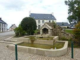
The modern fountain, with the town hall in the background, in Collorec | |
 Collorec | |
|
Location within Brittany region  Collorec | |
| Coordinates: 48°17′09″N 3°46′22″W / 48.2858°N 3.7728°WCoordinates: 48°17′09″N 3°46′22″W / 48.2858°N 3.7728°W | |
| Country | France |
| Region | Brittany |
| Department | Finistère |
| Arrondissement | Châteaulin |
| Canton | Châteauneuf-du-Faou |
| Intercommunality | Haute Cornouaille |
| Government | |
| • Mayor (2014–2020) | Patrick Nicot |
| Area1 | 28.00 km2 (10.81 sq mi) |
| Population (2008)2 | 667 |
| • Density | 24/km2 (62/sq mi) |
| Time zone | CET (UTC+1) |
| • Summer (DST) | CEST (UTC+2) |
| INSEE/Postal code | 29036 / 29530 |
| Elevation | 72–221 m (236–725 ft) |
|
1 French Land Register data, which excludes lakes, ponds, glaciers > 1 km² (0.386 sq mi or 247 acres) and river estuaries. 2 Population without double counting: residents of multiple communes (e.g., students and military personnel) only counted once. | |
Collorec (Breton: Koloreg) is a commune in the Finistère department of Brittany in north-western France.
Demographics
The inhabitants of Collorec are called in French Collorecois.
| Historical population | ||
|---|---|---|
| Year | Pop. | ±% |
| 1793 | 1,048 | — |
| 1800 | 1,198 | +14.3% |
| 1806 | 913 | −23.8% |
| 1821 | 871 | −4.6% |
| 1831 | 1,308 | +50.2% |
| 1836 | 1,328 | +1.5% |
| 1841 | 1,328 | +0.0% |
| 1846 | 1,352 | +1.8% |
| 1851 | 1,312 | −3.0% |
| 1856 | 1,234 | −5.9% |
| 1861 | 1,239 | +0.4% |
| 1866 | 1,325 | +6.9% |
| 1872 | 1,260 | −4.9% |
| 1876 | 1,339 | +6.3% |
| 1881 | 1,339 | +0.0% |
| 1886 | 1,439 | +7.5% |
| 1891 | 1,354 | −5.9% |
| 1896 | 1,578 | +16.5% |
| 1901 | 1,650 | +4.6% |
| 1906 | 1,801 | +9.2% |
| 1911 | 1,948 | +8.2% |
| 1921 | 1,880 | −3.5% |
| 1926 | 1,834 | −2.4% |
| 1931 | 1,661 | −9.4% |
| 1936 | 1,619 | −2.5% |
| 1946 | 1,554 | −4.0% |
| 1954 | 1,271 | −18.2% |
| 1962 | 1,148 | −9.7% |
| 1968 | 1,038 | −9.6% |
| 1975 | 891 | −14.2% |
| 1982 | 778 | −12.7% |
| 1990 | 692 | −11.1% |
| 1999 | 647 | −6.5% |
| 2008 | 667 | +3.1% |
See also
References
- Mayors of Finistère Association (French);
External links
| Wikimedia Commons has media related to Collorec. |
- Official website (French)
- French Ministry of Culture list for Collorec (French)
This article is issued from Wikipedia - version of the 2/12/2016. The text is available under the Creative Commons Attribution/Share Alike but additional terms may apply for the media files.