Pleyben
| Pleyben Pleiben | ||
|---|---|---|
|
Parish close | ||
| ||
 Pleyben | ||
|
Location within Brittany region  Pleyben | ||
| Coordinates: 48°13′36″N 3°58′05″W / 48.2267°N 3.9681°WCoordinates: 48°13′36″N 3°58′05″W / 48.2267°N 3.9681°W | ||
| Country | France | |
| Region | Brittany | |
| Department | Finistère | |
| Arrondissement | Châteaulin | |
| Canton | Pleyben | |
| Intercommunality | Région de Pleyben | |
| Government | ||
| • Mayor (2014–2020) | Annie Le Vaillant | |
| Area1 | 76.04 km2 (29.36 sq mi) | |
| Population (2008)2 | 3,667 | |
| • Density | 48/km2 (120/sq mi) | |
| Time zone | CET (UTC+1) | |
| • Summer (DST) | CEST (UTC+2) | |
| INSEE/Postal code | 29162 / 29190 | |
| Elevation | 14–176 m (46–577 ft) | |
|
1 French Land Register data, which excludes lakes, ponds, glaciers > 1 km² (0.386 sq mi or 247 acres) and river estuaries. 2 Population without double counting: residents of multiple communes (e.g., students and military personnel) only counted once. | ||
.JPG)
.svg.png)
Pleyben (Breton: Pleiben) is a commune in the Châteaulin arrondisement of Finistère department of Brittany in north-western France. The calvary in the churchyard dates from 1555.
Population
Inhabitants of Pleyben are called in French Pleybennois.
| Year | 1793 | 1800 | 1806 | 1821 | 1831 | 1836 | 1841 | 1846 | 1851 | 1856 |
|---|---|---|---|---|---|---|---|---|---|---|
| Population | 3676 | 4014 | 4019 | 4040 | 4508 | 4635 | 4672 | 5010 | 4901 | 4897 |
| Year | 1861 | 1866 | 1872 | 1876 | 1881 | 1886 | 1891 | 1896 | 1901 | 1906 |
|---|---|---|---|---|---|---|---|---|---|---|
| Population | 5164 | 5289 | 4908 | 5227 | 5327 | 5324 | 5683 | 5617 | 5579 | 5643 |
| Year | 1911 | 1921 | 1926 | 1931 | 1936 | 1946 | 1954 | 1962 | 1968 | 1975 |
|---|---|---|---|---|---|---|---|---|---|---|
| Population | 5541 | 4955 | 5012 | 4579 | 4562 | 4575 | 3998 | 3840 | 3713 | 3477 |
| Year | 1982 | 1990 | 1999 | 2008 |
|---|---|---|---|---|
| Population | 3491 | 3446 | 3397 | 3667 |
See also
- Communes of the Finistère department
- Parc naturel régional d'Armorique
- Yann Larhantec Sculptor "Croix de cimetière" in Pleyben
- Pleyben Parish close
- Roland Doré sculptor Sculptor of Pleyben calvary
- Calvary at Plougonven
- List of the works of the Maître de Thégonnec
References
- Mayors of Finistère Association (French)
 Saint-Germain Church,
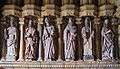
Left side of porch Saint-Germain Church,
Right side of porch Saint-Germain Church,
Nave and choir Saint-Germain Church,
Stained-glass windows of the choir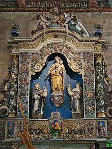 Saint-Germain Church,
Retable of the Rosary Saint-Germain Church,
The great organs
External links
| Wikimedia Commons has media related to Pleyben. |
This article is issued from Wikipedia - version of the 1/23/2016. The text is available under the Creative Commons Attribution/Share Alike but additional terms may apply for the media files.