Île-Tudy
| Île-Tudy Enez-Tudi | |
|---|---|
|
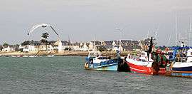
Île-Tudy, from Loctudy | |
 Île-Tudy | |
|
Location within Brittany region  Île-Tudy | |
| Coordinates: 47°50′36″N 4°10′01″W / 47.8433°N 4.1669°WCoordinates: 47°50′36″N 4°10′01″W / 47.8433°N 4.1669°W | |
| Country | France |
| Region | Brittany |
| Department | Finistère |
| Arrondissement | Quimper |
| Canton | Pont-l'Abbé |
| Intercommunality | Pays Bigouden Sud |
| Government | |
| • Mayor (2014–2020) | Éric Jousseaume |
| Area1 | 1.26 km2 (0.49 sq mi) |
| Population (2008)2 | 691 |
| • Density | 550/km2 (1,400/sq mi) |
| Time zone | CET (UTC+1) |
| • Summer (DST) | CEST (UTC+2) |
| INSEE/Postal code | 29085 / 29980 |
| Elevation | 0–5 m (0–16 ft) |
|
1 French Land Register data, which excludes lakes, ponds, glaciers > 1 km² (0.386 sq mi or 247 acres) and river estuaries. 2 Population without double counting: residents of multiple communes (e.g., students and military personnel) only counted once. | |
Île-Tudy (Breton: Enez-Tudi) is a commune in the Finistère department of Brittany in northwestern France.
Population
Inhabitants of Île-Tudy are called in French Îliens.
History
The United States Navy established a naval air station on 14 March 1918 to operate seaplanes during World War I. The base closed shortly after the First Armistice at Compiègne.[1]
See also
References
- ↑ Van Wyen, Adrian O. (1969). Naval Aviation in World War I. Washington, D.C.: Chief of Naval Operations. p. 61.
- Mayors of Finistère Association (French);
External links
- Official website (English)
| Wikimedia Commons has media related to Île-Tudy. |
This article is issued from Wikipedia - version of the 3/15/2016. The text is available under the Creative Commons Attribution/Share Alike but additional terms may apply for the media files.