Plabennec
| Plabennec Plabenneg | ||
|---|---|---|
|
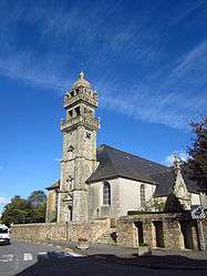
The church of Saint-Ténénan, in Plabennec | ||
| ||
 Plabennec | ||
|
Location within Brittany region  Plabennec | ||
| Coordinates: 48°30′10″N 4°25′29″W / 48.5028°N 4.4247°WCoordinates: 48°30′10″N 4°25′29″W / 48.5028°N 4.4247°W | ||
| Country | France | |
| Region | Brittany | |
| Department | Finistère | |
| Arrondissement | Brest | |
| Canton | Plabennec | |
| Intercommunality | Plabennec et des Abers | |
| Government | ||
| • Mayor (2014–2020) | Marie-Annick Créac'h-Cadec | |
| Area1 | 50.43 km2 (19.47 sq mi) | |
| Population (2008)2 | 7,764 | |
| • Density | 150/km2 (400/sq mi) | |
| Time zone | CET (UTC+1) | |
| • Summer (DST) | CEST (UTC+2) | |
| INSEE/Postal code | 29160 / 29860 | |
| Elevation | 28–102 m (92–335 ft) | |
|
1 French Land Register data, which excludes lakes, ponds, glaciers > 1 km² (0.386 sq mi or 247 acres) and river estuaries. 2 Population without double counting: residents of multiple communes (e.g., students and military personnel) only counted once. | ||
.svg.png)
Plabennec (Breton: Plabenneg) is a commune in the Finistère department of Brittany in north-western France.
History
The area around Plabennec has been occupied since Neolithic times and into the Bronze Age. The commune of Plabennec was formed around the 6th century by a Breton, Saint Abennec. Its name comes from a portmanteau of two Breton language words, Plou and Abennec, which translates as Parish of Saint Abennec.
The land in the area is especially good for growing crops. Since the 19th century, things such as linen, hemp and wheat have been grown locally. In more recent times, with the advancement of agriculture, the land has started to be used for potato growing.
Population
Inhabitants of Plabennec are called in French Plabennecois.
| Historical population | ||
|---|---|---|
| Year | Pop. | ±% |
| 1793 | 3,080 | — |
| 1800 | 3,086 | +0.2% |
| 1806 | 3,779 | +22.5% |
| 1821 | 3,000 | −20.6% |
| 1831 | 3,831 | +27.7% |
| 1836 | 3,540 | −7.6% |
| 1841 | 3,555 | +0.4% |
| 1846 | 3,624 | +1.9% |
| 1851 | 3,752 | +3.5% |
| 1856 | 3,663 | −2.4% |
| 1861 | 3,557 | −2.9% |
| 1866 | 3,571 | +0.4% |
| 1872 | 3,556 | −0.4% |
| 1876 | 3,556 | +0.0% |
| 1881 | 3,658 | +2.9% |
| 1886 | 3,577 | −2.2% |
| 1891 | 3,658 | +2.3% |
| 1896 | 3,606 | −1.4% |
| 1901 | 3,628 | +0.6% |
| 1906 | 3,836 | +5.7% |
| 1911 | 3,887 | +1.3% |
| 1921 | 3,823 | −1.6% |
| 1926 | 3,758 | −1.7% |
| 1931 | 3,713 | −1.2% |
| 1936 | 3,768 | +1.5% |
| 1946 | 4,098 | +8.8% |
| 1954 | 4,036 | −1.5% |
| 1962 | 4,389 | +8.7% |
| 1968 | 4,484 | +2.2% |
| 1975 | 5,168 | +15.3% |
| 1982 | 6,435 | +24.5% |
| 1990 | 6,600 | +2.6% |
| 1999 | 6,992 | +5.9% |
| 2008 | 7,764 | +11.0% |
Breton language
In 2008, 13.88% of primary-school children in Plabennec attended bilingual schools.[1]
Economy
Since the 1960s a lot has changed in the economy of the area. The popularity of new vehicles and mechanicalisation of farming has led to certain professions, such as blacksmiths and saddlers, disappearing. However, many people are now moving to the area to live in the revamped barns and lodges.
Most money in the area comes from tourism (due to the fact it is only 10km from Brest Bretagne Airport), industry, hand-crafted goods and agriculture.
Sport
Plabennec is home to Championnat de France de football National side Stade Plabennecois, who play at the Stade de Kervéguen in the commune. The club also deals with other sports such as basketball, handball and volleyball.
International relations
Plabennec has been twinned with Waltenhofen in ![]() Germany since 1976.
Germany since 1976.
See also
References
- ↑ (French) Ofis ar Brezhoneg: Enseignement bilingue
External links
| Wikimedia Commons has media related to Plabennec. |
- Official commune website (French)
- Commune website (French)
- French Ministry of Culture list for Plabennec (French)