Radec, California
| Radec | |
|---|---|
| Populated place | |
| First settled | 1883 |
| Founded by | Samuel V. Tripp |
| Named for | "Cedar" spelled backwards |
| Elevation | 520 m (1,706 ft) |
| Time zone | PST (UTC-8) |
| • Summer (DST) | PDT (UTC-7) |
| Zip code | 92536 |
| Area code(s) | 951 |
| FIPS code | 06-59150 |
| GNIS feature ID | 252960 |
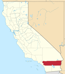
Located roughly six miles east by southeast of Temecula, California, the community of Radec ('Cedar' spelled backwards) is located along Highway 79. Having bought land in the area in 1883, early settler Samuel Tripp set up a post office there.[1] As of 1893–4, a local directory listed the area as growing honey, hay and stock, but also as having "no commercial interest of any kind." A total of 14 people, mainly farmers and beekeepers, plus a laborer and Tripp, are listed in the directory.[2] The County of Riverside owns the small, non-operating cemetery in Radec.[3]
References
- ↑ Lech, Steve (2004). Along the Old Roads: A History of the Portion of Southern California that became Riverside County: 1772–1893. Steve Lech. pp. 148–9. OCLC 56035822.
- ↑ Bynon, A.A. (1893). History and Directory of Riverside County, 1893–4 (PDF). Riverside, California: Riverside Daily Press. OCLC 26408357, 26432388
- ↑ Hunneman, John (July 13, 2001). "Nothing backward about Radec". San Diego Union Tribune.
- U.S. Geological Survey Geographic Names Information System: Radec Valley
- Hudson, Tom (1981). "Chapter 23: Beyond the 'City Limits'". A Thousand Years in Temecula Valley. Temecula, California: Old Town Temecula Museum. pp. 170–171. ISBN 978-0931700064. LCCN 81053017. OCLC 8262626. LCC F868.R6 H83 1981
Coordinates: 33°27′51″N 116°54′50″W / 33.4642°N 116.9139°W
This article is issued from Wikipedia - version of the 9/13/2015. The text is available under the Creative Commons Attribution/Share Alike but additional terms may apply for the media files.