Lake Elsinore, California
| City of Lake Elsinore | ||
|---|---|---|
| City | ||
|
View of Lake Elsinore and surrounding area | ||
| ||
| Motto: "Dream Extreme"[1] | ||
 Location in Riverside County | ||
 City of Lake Elsinore Location in the United States | ||
| Coordinates: 33°40′53″N 117°20′43″W / 33.68139°N 117.34528°WCoordinates: 33°40′53″N 117°20′43″W / 33.68139°N 117.34528°W | ||
| Country | United States | |
| State | California | |
| County | Riverside | |
| Incorporated | April 9, 1888[2] | |
| Government | ||
| • Mayor | Steve Manos[3] | |
| • Treasurer | Allen P. Baldwin[4] | |
| Area[5] | ||
| • Total | 41.687 sq mi (107.970 km2) | |
| • Land | 36.208 sq mi (93.779 km2) | |
| • Water | 5.479 sq mi (14.19 km2) 13.14% | |
| Elevation[6] | 1,296 ft (395 m) | |
| Population (April 1, 2010)[7] | ||
| • Total | 51,821 | |
| • Estimate (2013)[7] | 57,525 | |
| • Density | 1,200/sq mi (480/km2) | |
| Time zone | PST (UTC−8) | |
| • Summer (DST) | PDT (UTC−7) | |
| ZIP codes | 92530–92532 | |
| Area code | 951 | |
| FIPS code | 06-39486 | |
| GNIS feature IDs | 1652704, 2411601 | |
| Website |
www | |
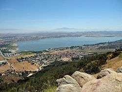

Lake Elsinore is a city in western Riverside County, California, United States. Established as a city in 1888, it is on the shore of Lake Elsinore, a natural freshwater lake about 3,000 acres (1,200 ha) in size. The city has grown from a small resort town in the late 19th century and early 20th century to a population of 51,821 at the 2010 census.
History
Native Americans have long lived in the Elsinore Valley. The Luiseño people were the earliest known inhabitants. Their pictographs can be found on rocks on the Santa Ana Mountains and in Temescal Valley, and artifacts have been found all around Lake Elsinore and in the local canyons and hills.
Overlooked by the expedition of Juan Bautista de Anza, the largest natural lake in Southern California was first seen by the Spanish Franciscan padre Juan Santiago, exploring eastward from the Mission San Juan Capistrano in 1797. In 1810, the water level of the Laguna Grande was first described by a traveler as being little more than a swamp about a mile long.[8] Later in the early 19th century, the lake grew larger, providing a spot to camp and water their animals for Mexican rancheros, American trappers, the expedition of John C. Frémont, and the immigrants during the California Gold Rush as they traveled along the southern shore of the lake on what later became the Southern Emigrant Trail and the route of the Butterfield Overland Mail.
On January 7, 1844, Julian Manriquez acquired the land grant to Rancho La Laguna, a tract of almost 20,000 acres (8,100 ha) which included the lake and an adobe being built near the lake on its south shore at its western corner that was described by Benjamin Ignatius Hayes, who stayed there overnight January 27, 1850.[9]
In 1851, Abel Stearns acquired the rancho and sold it in 1858 to Augustin Machado. Augustin Machado built a seven-room adobe ranch house and an outbuilding on the southwest side of the lake. Soon after, Rancho La Laguna became a regular stop on the Butterfield Overland Mail route between Temecula 20 mi (32 km) to the south and the Temescal station 10 mi (16 km) to the north. The old Manriquez adobe was used as the station house. Over the years, a framed addition and a second story were added, and it was used as a post office for the small settlement of Willard from 1898 until September 30, 1902. The building stood until it was razed in 1964, at what is now 32912 Macy Street. Today, three palm trees still grow in front of the site along Macy Street in front of the property.[10][11]
As a result of the Great Flood of 1862, the level of the lake was very high, so the Union Army created a post at the lake to graze and water their horses. In the great 1862–65 drought, most of the cattle in Southern California died and the lake level fell, especially during 1866 and 1867, when practically no rain fell. However, the lake was full again in 1872, when it overflowed down its outlet through Temescal Canyon.[12]
While most of the old Californio families lost their ranchos during the great drought, the La Laguna Rancho remained in the hands of the Machado family until 1873, when most of it was sold to Englishman Charles A. Sumner. Juan Machado retained 500 acres (200 ha) on the northwest corner of the lake, where his adobe still stands near the lake at 15410 Grand Avenue.
After 1872, the lake again evaporated to a very low level, but the great rains in the winter of 1883–84 filled it to overflowing in three weeks. Descriptions of the lake at this time say that large willow trees surrounding the former low-water shore line stood 20 ft (6.1 m) or more below the high-water level and were of such size that they must have been 30 or more years old. This indicated the high water of the 1860s and 1870s must have been of a very short duration.[13]
On October 5, 1883, Franklin H. Heald and his partners Donald Graham and William Collier bought the remaining rancho, intending to start a new town. In 1884, the California Southern Railroad built a line from Colton through the Cañon de Rio San Jacinto (now Railroad Canyon) to link with San Diego, and a rail station La Laguna appeared near the corner of what is now Mission Trail Road and Diamond Drive. On April 9, 1888, Lake Elsinore became the 73rd city to be incorporated in California, just 38 years after California became a state. Originally, Elsinore became a city in San Diego County and later part of Riverside County upon its creation in 1893. It was named Elsinore after the Danish city in Shakespeare's "Hamlet", which is now its sister city (Helsingør). Another source maintains Elsinore is a corruption of "el señor", Spanish for "the gentleman", because the city site had been owned by a don.[14]
The rainfall until 1893 was greater than normal, and the lake remained high and overflowed naturally on three or four occasions during that time. The lake water was purchased by the Temescal Water Company for the irrigation of land in Corona, California. Its outlet channel was deepened, permitting gravity flow down the natural channel of Temescal Canyon to Corona for a year or more after the water level sank below the natural elevation of its outlet. As the lake surface continued to recede, a pumping plant was installed and pumping was continued a few seasons, but the concentration of salts in the lake, due to the evaporation and lack of rainfall, soon made the water unfit for irrigation and the project was abandoned by the company.[13]
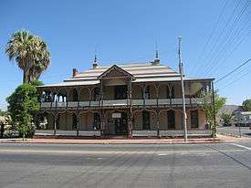
From the beginning, the mineral springs near the lake attracted visitors seeking therapeutic treatments. In 1887, the Crescent Bath House, now known as "The Chimes", was built; it still stands in historic downtown and is a registered national historic site. By 1888, the economy was supported by coal and clay mining at what became the town of Terra Cotta, gold mining in the Pinacate Mining District, ranching, and the agriculture of fruit and nuts. After 1893, the lake's water level sank almost continuously for nearly 10 years, with a slight rise every winter. Heavier precipitation, beginning in 1903, gradually filled the lake to about half the depth above its minimum level since 1883. Then in January, 1916, a flood rapidly raised the level to overflowing.
Lake Elsinore was a popular destination in the first half of the 1900s for celebrities to escape the urban Hollywood scene. Many of their homes still stand on the hills surrounding the lake, including Aimee's Castle, a unique Moorish-style house built by Aimee Semple McPherson. Also, actor Bela Lugosi, known for his lead role in Universal Pictures' film, Dracula, built a home that still exists in the city's Country Club Heights district. The lake also hosted teams for Olympic training and high-speed boat racing in the 1920s. The lake went dry in the mid-1930s, but refilled by 1938.[13]
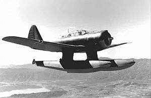
During World War II, the lake was used to test seaplanes, and a Douglas Aircraft plant making wing assemblies for Boeing B-17 Flying Fortress bombers was located in the city.[15]
The lake ran dry during most of the 1950s and was refilled in the early 1960s. Despite its relatively small African American population, it has the distinction of electing the first black mayor in California. Tom Yarborough was elected in 1966, three years before Douglas Dollarhide became the mayor of Compton.
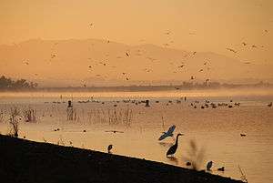
In 1972, citizens of the city voted to rename it Lake Elsinore.[16] More than a week of heavy rains in 1980 flooded the lake, destroying surrounding homes and businesses. Since then, a multimillion-dollar project has been put into place to maintain the water supply at a consistent level, allowing for homes to be built close to the lake. Overflow water in the Lake spills out via Alberhill Creek, a tributary of Temescal Creek. In 2007, an aeration system was added to help with the lake's ecosystem.
Rapid population growth in the mid-2000s altered the appearance and image of Lake Elsinore from a small lakeside town of 3,800 people in 1976 to a bedroom community of upper middle-class professionals. The city was ranked as the 12th fastest growing city in California between 2000 and 2008.[17] Now, over 51,821 residents as of the 2010 census live there, and formerly open hillsides have been converted into housing tracts.[18]
Geography

According to the United States Census Bureau, the city has a total area of 41.7 sq mi (108.0 km2) of which 36.2 sq mi (93.8 km2) of it is land and 5.5 sq mi (14.2 km2), or 13.14%, is covered by water.
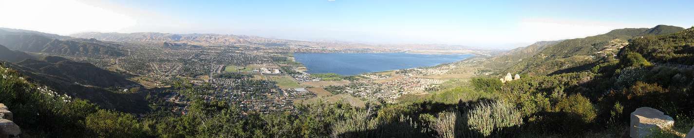
Lake Elsinore, originally Laguna Grande, is the largest natural freshwater lake in Southern California and is situated at the lowest point within the 750-square-mile (1,900 km2) San Jacinto River watershed at the terminus of the San Jacinto River, where its headwaters are found on the western slopes of San Jacinto Peak with its North Fork, and Lake Hemet with its South Fork. Lake levels are healthy at 1,244 feet (379 m) above sea level with a volume of 30,000 acre·ft (37 Gl)[19] that often fluctuate, although much has been done recently to prevent the lake from drying up, flooding, or becoming stagnant. At 1,255 feet (383 m), the lake would spill into the outflow channel on its northeastern shore, known properly as Temescal Wash, flowing northwest along I-15, which feeds Temescal Creek, which dumps into the Santa Ana River just northwest of the City of Corona. It then flows to Orange County, out to the Pacific Ocean just south of Huntington State Beach.
Lake Elsinore is bordered by the Elsinore Mountains to the west, which are a part of the larger Santa Ana Mountain Range, and receive a few inches of snowfall a few days each year. Included in the Santa Ana Mountains is the Cleveland National Forest and the community of El Cariso. Lake Elsinore is northwest of Wildomar and the northern portion is part of the Temescal Canyon. To the east of the lake are the much older and more eroded slopes of the Temescal Mountains.
Districts
Lake Elsinore is a city which encompasses a large geographical area. To better distinguish the wide range of neighborhoods, the city is organized into 11 districts. Each district beholds its own unique geography, culture, age, and history which together make Lake Elsinore a very diverse and culturally rich city. They are the Alberhill, Ballpark, Business, Country Club Heights, East Lake, Historic, Lake Edge, Lake Elsinore Hills, Lake View, North Peak, and Riverview Districts.[20]

Alberhill
The Alberhill District is characterized by rolling terrain, vacant land, and the newly constructed Alberhill Ranch neighborhood. Much of the topography in the central areas, east and west of Lake Street, has been substantially altered as a result of the Alberhill District's long history of extractive/mining activities. Mining operations in the Alberhill District began at Terra Cotta roughly the same time the region's first railroad, the California Southern Railroad, was completed in the 1880s. A spur of the railroad originally built to Terra Cotta was extended into the central portion of the Alberhill District. The Atchison, Topeka, and Santa Fe Railroad built a line up from Corona through Alberhill to Elsinore after the line through Railroad Canyon was washed out in the 1920s. These events helped shape the growth of the District. Mining operations for coal and especially clay have continued to exist since the late 19th century, and occupy a significant portion of the Alberhill District. Through the years, Pacific Clay Products Company has purchased the local mines and has become the sole operating clay mine in the region.[21]
Ballpark
The Ballpark District takes its name from the Lake Elsinore Diamond Stadium, a first-class minor league baseball stadium constructed in 1994. It is home to the Lake Elsinore Storm professional baseball team, an affiliate of the San Diego Padres. The area was once the site of the first train depot in Lake Elsinore, but no train tracks or structures from that era remain.[22]
Business
The developed area within the Business District, in Warm Springs Valley, is relatively new and has the strongest concentration of industrial and commercial uses within the city. In addition, it hosts several big-box retailers, the Lake Elsinore Outlets, the lake's outlet channel, Temescal Creek, and marshlands. It is bordered by Country Club Heights to the west and Interstate 15 to the east, with a small portion extending to the east side of I-15. Sections of the Atchison, Topeka, & Santa Fe Railroads that passed through the Business District during the 1800s have been removed. In addition, a historic ranching and homesteading site with previous ranching and homesteading activities is located nearby the route where the railroad once existed.[23]

Country Club Heights
The Country Club Heights District is distinctly marked by the steep hillsides of the Clevelin Hills, views of the lake and the City, and is a key part of Lake Elsinore's history. The issues mentioned above have presented development constraints for Country Club Heights since its historic beginnings dating back to 1912. The area was the target of an elaborate land scheme promoted in Los Angeles. The Mutual Benefit and Loan Society of Los Angeles acquired two pieces of dry, "hill-land" within a few miles north of "town-land" that the Press claimed was not worth ten cents an acre. The Mutual Benefit and Loan Society offered to give a 25-by-100-foot (7.6 m × 30.5 m) lot to anyone who asked; however, the person receiving the lot had to pay ten dollars for a membership in the society, and one dollar per month dues for five years. In 1923, the Clevelin Realty Corporation, headed by Henry Schultz, began selling additional lots in Country Club Heights and launched a real estate sales promotion in the area. The Clevelin Hills took their name from this company. Later, in 1925, W.R. Covington and Associates of Santa Monica purchased 650 ft (200 m) of lake frontage and three blocks of slightly improved land across Poe Street from Warm Springs Park. A clubhouse, swimming pool, and other facilities projected to cost $200,000 were built on this property. No records have been found to provide the date when a fire destroyed the clubhouse, but remnants of the burned structure and surrounding trees examined in 1942 indicate the fire must have occurred soon after the building was constructed. Noteworthy sites in the Country Club Heights District include the Bredlau Castle, built on a hilltop in 1926 by Henry Schultz, who had originated the Clevelin development. The beautiful building overlooking the lake was the site for many social gatherings. The castle is over 9,000 sq ft (840 m2), including a hidden room with a sliding bookcase door that was used during Prohibition. In October 1928, Aimee Semple McPherson, a renowned evangelist, built a palatial home in Country Club Heights, which has since won fame as "Aimee's Castle", which served as the evangelist's part-time home until 1939, when it passed to new ownership. Since then it has changed hands many times and is rumored to be owned by actor Johnny Depp.[24]
East Lake
The East Lake District is partially developed and contains the newly constructed Summerly neighborhood. It is a generally flat area that does not contain any registered historic structures. However, portions of the East Lake District were used during prehistoric times by Native American Indians as flaking and grinding stations. In addition, a historic ranching and homesteading site is located just outside the East Lake District along the border with Lakeland Village to the southwest. More recently, the East Lake District has also been home to popular motocross, skydiving, glider plane, and hang gliding activities. Throughout the city's history, Lake Elsinore has alternated between severe floods and droughts. Most of the East Lake District lies within a 100-year floodplain adjacent to and southeast of the lake. As a result, the district has been significantly affected during wet seasons and high water levels in the lake. Major floods occurred in 1884 and in 1916. In 1969, 7 in (180 mm) of rain fell in 11 days and severely flooded the lake's shores. The East Lake District's proximity to the lake and flood storage is a key consideration in all planned development and several projects have been implemented to prevent the lake from flooding again.[25]
Historic District
The Historic District has been the focal point of the city since its incorporation in 1888. Today, several unregistered historic buildings exist, including the Crescent Bath House, also known as "The Chimes". The neighborhoods in this area are the oldest in the city, and its commercial strip along Main Street is considered to be downtown.[26]
Lake Edge District
The Lake Edge District area has had a long and eventful history, with the lake as a focal point for the Native Americans, Europeans, Mexicans, early founders of the City, and the multitude of visitors and locals who continue to come to its shores for entertainment and recreation. Many developments occurred along or within proximity of the lake's edge during the second half of the 19th and the first half of the 20th centuries. Today, the Lake Edge District encompasses the city's oldest standing structure, the Adobe Machado House. The preservation of this structure is a high priority. Another structure of historical interest is the former Elsinore Naval Military Academy building, located along Grand Avenue near the intersection of Ortega Highway.[27] A newly constructed campground, marina, and boat lunch is located on the northwest side of the lake.
Lake Elsinore Hills
The Lake Elsinore Hills District encompasses a large and varied terrain including broad plains, rolling hills, bronie zones, steep slopes, sensitive habitats, and watercourses, with elevations ranging from 1,300 to 2,170 feet (400 to 660 m) above the sea level. Many areas of the Lake Elsinore Hills District are not readily accessible or able to be developed, so have remained vacant. Two large bodies of water located within close proximity of the Lake Elsinore Hills District are the City's lake to the southwest and Canyon Lake to the east, which is located within the city of Canyon Lake. Some of the higher elevations offer beautiful panoramic views of the City's lake and the Santa Ana Mountains. The neighborhoods in this district include Tuscany Hills, Canyon Hills, and Rosetta Canyon.[28]
Lake View
The northwestern areas of the Lake View District offer beautiful views of the lake and the neighboring mountains, and are characterized by high elevations, steep slopes, and a series of canyons. The remaining areas of the Lake View District are relatively flat in the lower elevations. Historically, the northern portion of the Lake View District has remained mostly undeveloped, with the exception of the La Laguna Estates neighborhood above McVicker Canyon Park. Similar to the areas further north, the Atchison, Topeka, and Santa Fe Railroad and abundant mining opportunities extant in the late 19th century brought both residents and visitors to the area. Historic ranching and homesteading, including Torn Ranch, were generally located to the northwest of Machado Street, which was an important roadway lined with beautiful deodar trees. Most of the lower-lying areas of the Lake View District to the north have been recently developed and primarily include single-family homes. Other neighborhoods in this area include Northshore and Lake Terrace, which were both formerly orange groves. Another area in this district at the intersection of Riverside and Lakeshore Drives has long been to referred to as "Four Corners" by local residents.[29]
North Peak
The North Peak District is located at the foothills of the Temescal Mountains and reflects three basic topographical conditions. The southern areas adjacent to State Highway 74 consist of gently rolling hills and small valleys. The central areas contain an enclosed valley. The northern areas primarily contain relatively flatter topography surrounded by rolling hillsides. Several historic mining locations and historic ranching and homesteading sites lie within the North Peak District, but most of the area remains pristine, coastal sage scrub. The landscape and character of the area may soon change as a result of proposed development. The future master-planned communities within the North Peak Specific Plan encompass a large share of the district's central and northern areas.[30]
Riverview
The Riverview District is a combination of steep terrain and flat areas nestled between a knoll with steep slopes, a major watercourse, and the lake. Higher elevations and steep slopes are located in the northwest areas of the Riverview District, which function as a physical border with most of the adjacent Historic District. The San Jacinto River floodway, located within the Riverview District along the eastern and southern areas, is the city's major watercourse. The river flows southwest from Canyon Lake through the Lake Elsinore Hills District and the Riverview District, then ultimately empties into the lake.[31]
Climate
Lake Elsinore has a semiarid climate, with hot, almost rainless summers and mild, wetter winters. The climate in this area is described by the Köppen climate classification system as "dry-summer subtropical" often referred to as "Mediterranean" and designated Csa.[32]
- On average, the hottest month is July.
- The highest recorded temperature was 118 °F (48 °C) in 1960.
- On average, the coolest month is December.
- The lowest recorded temperature was 10 °F (−12 °C) in 1974.
- The maximum average precipitation occurs in February.
| Climate data for Lake Elsinore, California | |||||||||||||
|---|---|---|---|---|---|---|---|---|---|---|---|---|---|
| Month | Jan | Feb | Mar | Apr | May | Jun | Jul | Aug | Sep | Oct | Nov | Dec | Year |
| Record high °F (°C) | 91 (33) |
95 (35) |
103 (39) |
109 (43) |
109 (43) |
114 (46) |
117 (47) |
118 (48) |
114 (46) |
110 (43) |
98 (37) |
90 (32) |
118 (48) |
| Average high °F (°C) | 65.4 (18.6) |
67.5 (19.7) |
71.0 (21.7) |
76.3 (24.6) |
81.8 (27.7) |
90.5 (32.5) |
98.1 (36.7) |
98.1 (36.7) |
93.5 (34.2) |
83.7 (28.7) |
74.1 (23.4) |
66.9 (19.4) |
80.58 (26.99) |
| Average low °F (°C) | 36.4 (2.4) |
38.7 (3.7) |
41.2 (5.1) |
44.7 (7.1) |
49.8 (9.9) |
54.1 (12.3) |
59.4 (15.2) |
59.8 (15.4) |
55.8 (13.2) |
48.8 (9.3) |
41.1 (5.1) |
36.5 (2.5) |
47.19 (8.44) |
| Record low °F (°C) | 15 (−9) |
19 (−7) |
24 (−4) |
24 (−4) |
31 (−1) |
35 (2) |
41 (5) |
40 (4) |
32 (0) |
25 (−4) |
20 (−7) |
10 (−12) |
10 (−12) |
| Average rainfall inches (mm) | 2.47 (62.7) |
2.54 (64.5) |
2.03 (51.6) |
0.75 (19) |
0.23 (5.8) |
0.02 (0.5) |
0.08 (2) |
0.12 (3) |
0.26 (6.6) |
0.51 (13) |
0.99 (25.1) |
2.01 (51.1) |
12.01 (304.9) |
| Average rainy days (≥ 0.01 inch) | 6 | 6 | 5 | 3 | 1 | 0 | 0 | 1 | 1 | 2 | 3 | 5 | 33 |
| Source: [33] | |||||||||||||
Demographics
| Historical population | |||
|---|---|---|---|
| Census | Pop. | %± | |
| 1900 | 279 | — | |
| 1910 | 488 | 74.9% | |
| 1920 | 633 | 29.7% | |
| 1930 | 1,350 | 113.3% | |
| 1940 | 1,552 | 15.0% | |
| 1950 | 2,068 | 33.2% | |
| 1960 | 2,432 | 17.6% | |
| 1970 | 3,530 | 45.1% | |
| 1980 | 5,982 | 69.5% | |
| 1990 | 18,285 | 205.7% | |
| 2000 | 28,928 | 58.2% | |
| 2010 | 51,821 | 79.1% | |
| Est. 2015 | 61,981 | [34] | 19.6% |
2010
The 2010 United States Census[36] reported Lake Elsinore to have a population of 51,821. The population density was 1,243.1 people per square mile (480.0/km²). The racial makeup of Lake Elsinore was 31,067 (60.0%) White (37.8% Non-Hispanic White),[37] 2,738 (5.3%) African American, 483 (0.9%) Native American, 2,996 (5.8%) Asian, 174 (0.3%) Pacific Islander, 11,174 (21.6%) from other races, and 3,189 (6.2%) from two or more races. Hispanics or Latinos of any race were 25,073 persons (48.4%).
The census reported 51,389 people (99.2% of the population) lived in households, 224 (0.4%) lived in non-institutionalized group quarters, and 208 (0.4%) were institutionalized.
Of the 14,788 households, 8,026 (54.3%) had children under the age of 18 living in them, 8,735 (59.1%) were married couples living together, and 2,071 (14.0%) had a female householder with no husband present, 1,155 (7.8%) had a male householder with no wife present. There were 1,165 (7.9%) unmarried opposite-sex partnerships, and 143 (1.0%) same-sex partnerships. Some 1,952 households (13.2%) were made up of individuals and 521 (3.5%) had someone living alone who was 65 years of age or older. The average household size was 3.48. There were 11,961 families (80.9% of all households); the average family size was 3.79.
The population was distributed as 16,990 people (32.8%) under the age of 18, 5,261 people (10.2%) aged 18 to 24, 15,731 people (30.4%) aged 25 to 44, 10,874 people (21.0%) aged 45 to 64, and 2,965 people (5.7%) who were 65 years of age or older. The median age was 29.8 years. For every 100 females, there were 100.4 males. For every 100 females age 18 and over, there were 98.5 males.
The 16,253 housing units averaged a density of 389.9 per square mile (150.5/km²), of which 9,761 (66.0%) were owner-occupied, and 5,027 (34.0%) were occupied by renters. The homeowner vacancy rate was 4.6%; the rental vacancy rate was 6.8%. About 32,891 people (63.5% of the population) lived in owner-occupied housing units and 18,498 people (35.7%) lived in rental housing units.
According to the 2010 United States Census, Lake Elsinore had a median household income of $62,436, with 13.2% of the population living below the federal poverty line.[37]
Government
In the California State Legislature, Lake Elsinore is in the 28th Senate District, represented by Republican Jeff Stone, and in the 67th Assembly District, represented by Republican Melissa Melendez.[38]
In the United States House of Representatives, Lake Elsinore is in California's 42nd congressional district, represented by Republican Ken Calvert.[39]
Services
Public safety
The Riverside County Sheriff's Department serves the entire Lake Elsinore Valley (including the nearby suburbs of Lakeland Village and Sedco Hills, and the newly incorporated City of Wildomar) from its regional station in downtown Lake Elsinore (the city once had its own police department, but it was disbanded in 1979 for budgetary reasons).
The city of Lake Elsinore contracts for fire and paramedic services with the Riverside County Fire Department through a cooperative agreement with CAL FIRE.[40] Lake Elsinore currently has three paramedic engines and one paramedic truck company operating from its four stations.
Fire station 10 is located downtown next to the post office, which also has two Cal Fire engines for supplemental protection. Fire station 85 is located at McVicker Park and fire station 94 is located on the east side of the city off of Railroad Canyon Road. Rosetta Canyon fire station 97 is located on the northeast side of the city covering the Highway 74 corridor.
Education
Public education within most of the city of Lake Elsinore and the surrounding areas is provided by the Lake Elsinore Unified School District, which serves a student population of about 21,500.[41] The school district has 15 elementary schools, five middle schools, three high schools, and three alternative schools.[42]
Lakeside, Temescal Canyon, and Elsinore are the three main high schools of the Lake Elsinore Unified School District A very small portion of northeastern Lake Elsinore in the Canyon Hills subdivision is located in the Menifee Union School District for grades K-8, and Perris Union High School District for grades 9–12.
Additionally, three private schools are within the city of Lake Elsinore, including a K–12 preparatory academy.[43][44]
Cemetery
The Elsinore Valley Cemetery District[45] maintains a public cemetery in the city.[46][47] The cemetery was established in 1891 by Peter Wall.[48] The Jewish Home of Peace Cemetery, a.k.a. Mt. Sinai Memorial Park of Elsinore, is part of the cemetery.[49]
The Manker Family Cemetery is an historical cemetery located on the family property. Three known burials are from 1887–1902, with evidence of at least one other burial. The four wooden tombstones were burned in a fire.[50]
Sports
Lake Elsinore Diamond
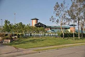
Lake Elsinore Diamond serves as a site for the Single A baseball team Lake Elsinore Storm, which is a farm team for the San Diego Padres, and was formerly a farm team for the Los Angeles Angels of Anaheim. Also, semipro football team, the Riverside-Elsinore Dolphins of the Western States Football League was active in 1996–98. The stadium now hosts the Banning-Elsinore Eagles of the California Football Association, a minor American football league. At this time, neither football or soccer is played at "the Diamond", but special events, such as concerts with stars such as Willie Nelson and ZZ Top, are held there.
Cross monument lawsuit
In 2012, the city council voted to approve $50,000 for a memorial to veterans that would be placed in front of the stadium. The design of the memorial included a soldier kneeling in front of a Christian cross. After repeated warnings to the city council that endorsing religion using public funds is unconstitutional, including a warning from the city attorney that this is "in no way legal", the city council unanimously voted to include a Star of David, as well as more Christian crosses, saying we are 'taking a stand' for Christianity and against the separation of church and state." On May 31, 2013, the American Humanist Association filed suit to prevent the building of the monument.[51][52][53][54] The Pacific Justice Institute, a nonprofit legal defense firm, agreed to represent the city on a pro bono basis.[55][56] A Federal Court injunction in July 2013 halted the project[57] and in a subsequent February 2014 ruling the court prevented the construction of the monument as designed.[57] In April 2014 the City Council declined to pursue an appeal against the decision and although the council incurred no costs for their own defence, the court awarded plaintiffs fees of $200,000 against the council.[58] The council also agreed at this time to develop a revised design for the memorial.[58] A council meeting in June 2014 approved an amended design.[59] The 3,600-pound (1,600 kg) memorial, absent of religious symbols, was finally installed and commemorated in November 2014.[60][61]
Elsinore Grand Prix
The Elsinore Grand Prix is a dirt-bike race that takes place in and around the Lake Elsinore area. The annual race is usually held in mid-November. The popularity of the event hit its apex in the late 1960s and early 1970s, drawing the likes of dirt-bike greats such as Malcolm Smith and Steve McQueen, to name a few. The race has always been set as an "open" format, meaning anyone can ride; usually only about 200 or so take this event seriously, whereas the rest use it as an opportunity to have fun. In 1971, the documentary movie On Any Sunday by Bruce Brown included scenes from the grand prix.[62]
In the mid-1970s the Elsinore Grand Prix hit a snag, none of the big riders were participating, and the event was drawing the wrong crowd, mostly violent motorcycle gangs. The race was cancelled indefinitely soon afterwards. In 1996, several dirt-bike riders, with a hint of nostalgia, decided to lobby the city of Lake Elsinore to revive the Grand Prix. Promising that the violent motorcycle gang crowd drawn to the Grand Prix in the 1970s had gone and that dirt-bike motorcycle riding was more of a family event, the city allowed the event to resume on a provisional basis.
In 1973, Honda named its CR250M Elsinore—the first motorcycle designed by Honda for the dirt rather than a modified street bike—after the Elsinore GP race venue.[63]
Lake Elsinore is also a popular destination for motorcyclists riding east from San Juan Capistrano along the 33-mile (53 km) long Ortega Highway.[62]
Skateparks
Lake Elsinore offers two skateparks in both north and south of the areas. McVicker Canyon Park was the first city-owned skatepark to be built in Lake Elsinore located between Grand Ave and McVicker Canyon Park Rd. Serenity Park was built in June 2015 located Palomar Rd. The city hired Spohn Ranch Skateparks, an internationally renowned firm in Los Angeles, for about $400,000 to design and build the state-of-the-art 8,500-square-foot, open-air plaza that features a peanut-shaped bowl, hip ramps, step-up and quarter-pipes. It is the second city-owned skatepark.
Economy
One of the first outlet shopping malls in California was established in northwestern Lake Elsinore in the late 1990s on Collier Road at Nichols Road, just off Interstate 15; the mall has a wide variety of retailers, encompassing clothing and shoe stores, eateries, bookstores, perfumeries, home and garden boutiques, and electronics stores.[64]
The city's Visitors Bureau has also been making efforts to expand tourism in the area. Quality Inn, Best Western, and Holiday Inn Express hotels have recently been built within the city limits to accommodate tourists who attend the city's various events and enjoy the picturesque lake. Also, Lake Elsinore Hotel and Casino has recently been remodeled to accommodate the growing need for hotel space in the region.
Top employers
According to the City's 2009 Comprehensive Annual Financial Report,[65] the top employers in the city are:
| # | Employer | No. of employees |
|---|---|---|
| 1 | Lake Elsinore Outlets | 1,169 |
| 2 | Lake Elsinore Unified School District | 1,060 |
| 3 | The Trap House | 978 |
| 4 | Walmart | 225 |
| 5 | Lowe's | 200 |
| 6 | The Home Depot | 200 |
| 7 | Target | 200 |
| 8 | Albertsons | 195 |
| 9 | Medley Communications | 175 |
| 10 | Lake Elsinore Storm | 175 |
| 11 | GBC Concrete and Masonry Construction | 170 |
| 12 | Stater Bros. | 165 |
| 13 | Pacific Clay | 160 |
| 14 | Lake Elsinore Hotel and Casino | 130 |
| 15 | Elsinore Valley Municipal Water District | 120 |
Notable people
References
- ↑ "City of Lake Elsinore, California Website". City of Lake Elsinore, California Website. Retrieved September 14, 2012.
- ↑ "California Cities by Incorporation Date" (Word). California Association of Local Agency Formation Commissions. Retrieved August 25, 2014.
- ↑ "Lake Elsinore City Council". City of Lake Elsinore. Retrieved December 16, 2014.
- ↑ "City Treasurer". City of Lake Elsinore. Retrieved September 22, 2014.
- ↑ "2010 Census U.S. Gazetteer Files – Places – California". United States Census Bureau.
- ↑ "Lake Elsinore". Geographic Names Information System. United States Geological Survey. Retrieved November 3, 2014.
- 1 2 "Lake Elsinore (city) QuickFacts". United States Census Bureau. Retrieved May 18, 2015.
- ↑ Water-supply paper, Volumes 425–429 By Geological Survey (U.S.), History of Elsinore Lake, p. 255
- ↑ Benjamin Ignatius Hayes, Edited and published by Marjorie Tisdale Wolcott, Pioneer notes from the diaries of Judge Benjamin Hayes, 1849–1875, Los Angeles, Priv. print., 1929. pp. 64–65
- ↑ Mildred Brooke Hoover, Historic Spots in California, Third Edition, Stanford University Press, Stanford, 1966. p. 390
- ↑ Historical Topographic Map, Elsinore, Edition Date: 1901, Scale 1/125000
- ↑ Water-supply paper, Volumes 425–429 By Geological Survey (U.S.), History of Elsinore Lake, p. 255]
- 1 2 3 Water-supply paper, Volumes 425–429 By Geological Survey (U.S.), History of Elsinore Lake, p. 255
- ↑ Gannett, Henry (1905). The Origin of Certain Place Names in the United States. Govt. Print. Off. p. 118.
- ↑ Tom Hudson, Lake Elsinore Valley, its story 1776–1977, 2nd Ed., Published by author, 1988. ISBN 0-931700-01-9
- ↑ Lake Elsinore Historical Society, Lake Elsinore, Arcadia Publishing, 2008, p. 10 ISBN 978-0738555881 OCLC 176900939
- ↑ "Pacific Standard Magazine". Retrieved April 27, 2012.
- ↑ "State & County QuickFacts". 2010 U.S. Census. United States Census Bureau. Retrieved April 15, 2012.
- ↑ http://www.swrcb.ca.gov/board_info/agendas/2002/july/0718-12.doc State Water Resources Control Board
- ↑ City of Lake Elsinore General Plan Revised 2011-12-13
- ↑ City of Lake Elsinore General Plan Adopted 2011-12-13
- ↑ City of Lake Elsinore General Plan Adopted 2011-12-13
- ↑ City of Lake Elsinore General Plan Adopted 2011-12-13
- ↑ City of Lake Elsinore General Plan Adopted 2011-12-13
- ↑ City of Lake Elsinore General Plan Adopted 2011-12-13
- ↑ City of Lake Elsinore General Plan Adopted 2011-12-13
- ↑ City of Lake Elsinore General Plan Adopted 2011-12-13
- ↑ City of Lake Elsinore General Plan Adopted 2011-12-13
- ↑ City of Lake Elsinore General Plan Adopted 2011-12-13
- ↑ City of Lake Elsinore General Plan Adopted 2011-12-13
- ↑ City of Lake Elsinore General Plan Adopted 2011-12-13
- ↑ Climate Summary for Lake Elsinore, CA
- ↑ "Lake Elsinore historic weather averages". Western Regional Climate Center. Retrieved December 24, 2012.
- ↑ "Annual Estimates of the Resident Population for Incorporated Places: April 1, 2010 to July 1, 2015". Retrieved July 2, 2016.
- ↑ "Census of Population and Housing". Census.gov. Retrieved June 4, 2015.
- ↑ "2010 Census Interactive Population Search: CA - Lake Elsinore city". U.S. Census Bureau. Retrieved July 12, 2014.
- 1 2 "Lake Elsinore (city) QuickFacts". United States Census Bureau.
- ↑ "Statewide Database". UC Regents. Retrieved December 16, 2014.
- ↑ "California's 42nd Congressional District - Representatives & District Map". Civic Impulse, LLC.
- ↑ http://rvcfire.org/ourDepartment/ServiceArea/Pages/default.aspx
- ↑ Lake Elsinore Unified School District schools – district elementary, middle, and high school information
- ↑ Lake Elsinore Unified School District
- ↑ http://www.localschooldirectory.com/city-schools/Lake-Elsinore/CA
- ↑ http://www.go2mountainside.com/
- ↑ California Association of Public Cemeteries, Members
- ↑ 33°41′40″N 117°20′29″W / 33.6944652°N 117.3414289°W USGS Geographic Names Information System (GNIS)
- ↑ Elsinore Valley Cemetery Find A Grave
- ↑ Shirley Brooks, "History of Elsinore Valley Cemetery", Lake Elsinore Genealogical Society accessdate=September 30, 2011
- ↑ "Lake Elsinore: Riverside County". International Jewish Cemetery Project. International Association of Jewish Genealogical Societies.
- ↑ Manker Family Cemetery Find A Grave
- ↑ "Lake Elsinore: Cross will remain on veterans memorial". The Press-Enterprise. Retrieved June 3, 2013.
- ↑ "The City of Lake Elsinore Voted to Build a Monument Honoring Christian Soldiers and Now They're Getting Sued". Patheos. Retrieved June 3, 2013.
- ↑ "Lake Elsinore: Humanist group sues over cross on planned monument". The Press-Enterprise. Retrieved June 3, 2013.
- ↑ "American Humanist Association Sues City of Lake Elsinore to Stop Cross Monument". American Humanist Association. Retrieved June 3, 2013.
- ↑ http://lakeelsinore-wildomar.patch.com/groups/politics-and-elections/p/lake-elsinores-religious-symbolism-lawsuit-being-defended-pro-bono-by-pji
- ↑ http://www.pacificjustice.org/1/post/2013/06/pji-to-defend-lake-elsinore-in-atheist-lawsuit-against-veterans-memorial.html
- 1 2 Sheridan, Tom (27 February 2014). "LAKE ELSINORE: Judge halts memorial planned for The Diamond". The Press-Enterprise. Retrieved 30 March 2015.
- 1 2 Williams, Michael (29 April 2014). "LAKE ELSINORE: Vets memorial dispute costs city $200,000". The Press-Enterprise. Retrieved 31 March 2015.
- ↑ Williams, Michael (12 June 2014). "LAKE ELSINORE: Veterans memorial plan gets council approval". The Press-Enterprise. Retrieved 31 March 2015.
- ↑ Williams, Michael (4 November 2014). "LAKE ELSINORE: Legal battles over, veterans memorial finally built". The Press-Enterprise. Retrieved 31 March 2015.
- ↑ "Preparations Underway, Veterans Memorial to be Unveiled". City of Lake Elsinore. 8 October 2014. Retrieved 31 March 2015.
- 1 2 Richard Backus (March–April 2007). "Lake Elsinore, Calif., via the Ortega Highway". Motorcycle Classics. Retrieved 2009-08-12.
- ↑ "1973 CR250M by Honda - Bike Museum at Bob Logue Motorsports". Retrieved 2010-06-02.
- ↑ http://www.lakeelsinoreoutlet.com/index.cfm
- ↑ City of Lake Elsinore, California Comprehensive Annual Financial Report, for the Year ended June 30, 2009
- ↑ George, Jacob. "Celebration of Art". Studio 395.
Further reading
- Greene, Edythe J.; Hepler, Elizabeth; Rowden, Mary Louise (2005). Lake Elsinore. Mt. Pleasant, SC: Arcadia Publishing. ISBN 978-0738530666.
External links
| Wikimedia Commons has media related to Lake Elsinore, California. |
| Wikivoyage has a travel guide for Lake Elsinore. |
- Official website
- Lake Elsinore Valley Chamber of Commerce
- Lake Elsinore, California at DMOZ
- Lake Elsinore Unified School District Site
- City-Data.com Comprehensive Statistical Data and more about Lake Elsinore
- Drawing depicting Rancho de La Laguna in California, ca.1870,; from USC Digital Library
- Sketch by Henry Chapman Ford, depicting the Laguna Rancho near the San Jacinto Mountains and Temecula, June, 1888; from USC Digital Library
- Photo of Machado Ranch and Stage Station at Lake Elsinor, California, ca. 1898–1900; from USC Digital Library
- Map of Elsinore San Diego County, California, (1883-1893). Town was first established in 1883, but was not incorporated until 1888; map must predate 1893, when Riverside County was founded, with Lake Elsinore in its limits. From the lake south through Wildomar. from Huntingon Digital Library website hdl.huntington.org.
- Elsinore, San Diego Co. Cal. Compliments of Wm. Varcoe & Co. Real Estate Dealers, Elsinore, Cal. (1887), "Lake Elsinore - 1280 feet above the sea, taken from mountain 1700 feet above the lake." Note lower left starts, "This representation of Lake Elsinore Valley, although in a primitive state of advancement, it being three years ago without population, will serve to convey to the mind of the observer some idea of the resplendent future in store for this Chautauqua of Southern California.". from Huntingon Digital Library website hdl.huntington.org. Note Lake level depicted is accurate, it was full and overflowed several times between 1884 and 1893.

Municipalities and communities of Riverside County, California, United States | ||
|---|---|---|
| Cities |  | |
| CDPs |
| |
| Unincorporated communities |
| |
| Indian reservations | ||
| Ghost towns | ||