Phu Soi Dao National Park
| Phu Soi Dao National Park | |
|---|---|
|
IUCN category II (national park) | |
 | |
 Location within Thailand | |
| Location | Thailand |
| Nearest city | Uttaradit |
| Coordinates | 17°44′N 101°0′E / 17.733°N 101.000°ECoordinates: 17°44′N 101°0′E / 17.733°N 101.000°E |
| Area | 340.21 km² |
| Established | 2008 |
Phu Soi Dao National Park (Thai: อุทยานแห่งชาติภูสอยดาว), named after 2,120 m high Phu Soi Dao mountain,[1] is a protected area at the southern end of the Luang Prabang Range in the Thai/Lao border area, on the Thai side of the range. It is located in Chat Trakan District of Phitsanulok and Nam Pat District of Uttaradit Provinces.[2] The park was established in 2008.[3]
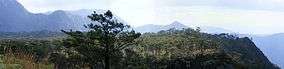
Phu Soi Dao waterfall and Saithip waterfall are some of the attractions of the park. The landscape is similar to the area on the Phu Kradueng plateau further southeast, with grasslands and pine trees such as Pinus kesiya. Betula alnoides, Schima wallichii and Shorea siamensis are among the other species of trees present in the forest. Utricularia spinomarginata and Utricularia phusoidaoensis are endemic plants on Phu Soi Dao.[4]
See also
References
External links
| Wikimedia Commons has media related to Phu Soi Dao National Park. |
- Trekthailand - Phu Soi Dao National Park
- National Parks & Marine Reserves - Phu Soi Dao National Park