Phi Pan Nam Range
| Phi Pan Nam Range | |
|---|---|
| ทิวเขาผีปันน้ำ | |
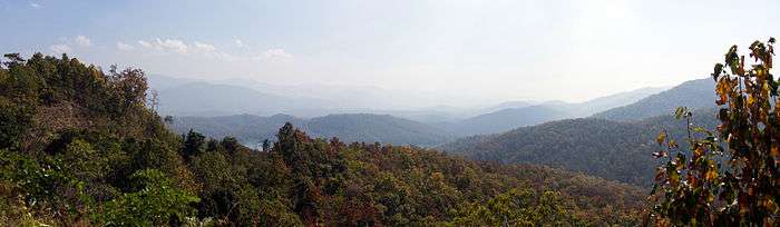
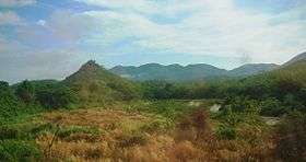 The Phi Pan Nam Range and the Yom River in Long District, Phrae Province | |
| Highest point | |
| Peak | Doi Luang |
| Elevation | 1,694 m (5,558 ft) |
| Coordinates | 19°8′04″N 99°45′29″E / 19.13444°N 99.75806°E |
| Dimensions | |
| Length | 400 km (250 mi) NE/SW |
| Width | 135 km (84 mi) SE/NW |
| Geography | |
 | |
| Countries | Thailand and Laos |
| Range coordinates | 18°48′00″N 99°50′30″E / 18.8°N 99.8417°ECoordinates: 18°48′00″N 99°50′30″E / 18.8°N 99.8417°E |
| Parent range | Thai highlands |
| Geology | |
| Age of rock | Triassic |
| Type of rock | Sandstone and laterite |


The Phi Pan Nam Range, also Pee Pan Nam,[1] (Thai: ทิวเขาผีปันน้ำ) is a 400 km (249 mi) long system of mountain ranges in the eastern half of the Thai highlands. It is mostly located in Thailand, although a small section in the northeast is within Sainyabuli and Bokeo Provinces, Laos.
In Thailand the range extends mainly across Chiang Rai, Phayao, Lampang, Phrae, Nan, Uttaradit and Sukhothai Provinces, reaching Tak Province at its southwestern end. The population density of the area is relatively low. Only two sizable towns, Phayao and Phrae, are located within the area of the mountain system and both have less than 20,000 inhabitants each. Larger towns, like Chiang Rai and Uttaradit, are located close to the limits of the Phi Pan Nam Range, in the north and in the south respectively.
Phahonyothin Road, part of the AH2 Highway system, crosses the Phi Pan Nam Range area from north to south, between Tak and Chiang Rai. There are two railway tunnels of the Northern Line across the Phi Pan Nam mountains. Both are located in the southern side of the range: the 130.20 m Huai Mae Lan Tunnel in Phrae Province and the 362.44 m Khao Phlueng Tunnel in Uttaradit and Phrae provinces.[2]
In the mountains north of Thoeng, at the NE end of the range, there are Hmong people living in small villages such as Ban Saen Than Sai and Ban Phaya Phripak, the latter located on top of a mountain pass.
Geography
The Phi Pan Nam Range is composed of many smaller mountain chains roughly aligned in a north-south direction in its northern part and, further south, in a NE - SW direction. These ranges cover an extensive area and are often separated by intermontane basins or lowlands. They limit in the west with the Khun Tan Range, in the east with the Luang Prabang Range, and with the Central Plain of Siam in the south. The northern tip is bound by the Mekong river.[3]
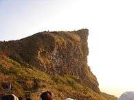
The highest point is the 1,694 m high summit known as Doi Luang.[4] It is located in the NW near Phayao town, but there are a number of less high mountains with the name 'Doi Luang' throughout the range such as 1,426 m high Doi Luang in Mae Chai District. Other important peaks are 1,608 m high Doi Pha Tang,[5] 1,628 m high Doi Pha Mon (at Phu Chi Fa), 1,603 m high Doi Cha Tong, 1,507 m high Doi Nang, 1,543 m high Doi Yao, 1,442 m high Phu Chi Fa, 1,403 m high Doi Phu Kheng, 1,396 m high Doi Luang, 1,328 m high Doi Luang Pae Mueang, 1,303 m high Khun Huai Han, 1,202 m high Doi Phu Nang,[6] 1,178 m high Doi Lan, 1,075 m high Doi Khun Mae Loe, 1,013 m high Doi Pha Mon, 938 m high Doi San Klang and 843 m high Doi Pui.
There are columnar basalt formations in Mon Hin Kong (Thai: ม่อนหินกอง) in an area in the mountains near Na Phun, Wang Chin District, Phrae Province.[7] In Phae Mueang Phi there are mushroom rocks and other bizarre rock formations caused by erosion.[8]
Subranges
The Phi Pan Nam range system is often divided in two physiographic longitudinal sections:
- Western Phi Pan Nam Range (เทือกเขาผีปันน้ำตะวันตก) or Phi Pan Nam Range proper, located in the NW between rivers Wang and Yom.[9] Some scholarly works designate the Khun Tan Range as the "Western Phi Pan Nam Range" and this section therefore as the "Central Phi Pan Nam Range".[10]
- Eastern Phi Pan Nam Range (เทือกเขาผีปันน้ำตะวันออก), also known as Phlueng Range (ทิวเขาพลึง) in the SE between the Yom and the Nan River.[11]
Hydrography
The Phi Pan Nam range of mountains is not as high as neighboring mountain systems. It is, however, very significant from the hydrographic point of view. These mountains divide the Mekong from the Chao Phraya watershed and important rivers of Thailand have their source in the Phi Pan Nam area. Its name in Thai "ทิวเขาผีปันน้ำ" roughly means "The mountains of the spirits dividing the waters", 'spirits' (ผี Phi) here referring to ancient mountain deities of the Thai folklore.
Among the Thai rivers that originate in the Phi Pan Nam Mountains the main ones are the Wang and Yom River, with their tributaries such as the Ngao, flowing towards the Chao Phraya. The Ing and the Lao, a tributary of the Kok River, flow northwards and are part of the Mekong basin. A great number of smaller rivers have their sources in mountains across the range.
The Sirikit Dam is located at the southeastern edge of the Phi Pan Nam mountains.
History

There were formerly large teak forests in some areas of the range. However, at the beginning of the 20th century concessions were given to logging companies and the forest cover dwindled dramatically especially in lowland areas between ranges.[12] Deforestation also has affected areas that were cleared for local agriculture. Often wildfires are deliberately set off by local farmers, as well as by speculators who hire people to set forests on fire in order to claim land title deeds for the areas that have become "degraded forest".[13]
Owing to the relative isolation of the area there was Communist insurgency in the mountainous forests of the Phi Pan Nam Range during the Cold War. A memorial has been erected at 1,118 m high Doi Phaya Phipak (ดอยพญาพิภักดิ์) in order to commemorate the victims of the battles between troops of the Royal Thai Armed Forces and the insurgents of the Communist Party of Thailand in the place between the 1950s and the 1970s.[14] There is now a historical site and a forest park at Doi Phaya Phipak, also known as Phaya Phipak.[15]
A controversial dam was planned in the central area of the range on the Yom River in Kaeng Suea Ten in 1991 but this project was later abandoned in the face of stiff popular opposition.[16] The debate about the dam was opened again in 2011.[17] Currently a proposal is being debated to build two smaller dams on the Yom River in the area instead of the Kaeng Suea Ten mega-dam.[18]
Ecology
Generally the forested areas of the Phi Pan Nam are known for their teak and bamboo forest. The mountain ranges are covered with tropical dry broadleaf forests, including sections of moist evergreen forest, mixed deciduous forest, dry deciduous forest, as well as hill evergreen forest at higher altitudes. There is great biodiversity in these mountains and their few unspoilt valleys, with a wide range of animal and plant species.[19]
There are a number of protected areas in the Phi Pan Nam mountains, mostly encompassing mountainous terrain. These are patchily distributed across the range, and the largest national parks are in its central part, roughly around Phayao town. Protected sectors are typically surrounded by agricultural zones, often near roads and villages and thus with vast surfaces under the influence of the edge effect.[20]
Besides the national parks and wildlife reserves, there are the Huai Tak Teak Biosphere Reserve in Lampang Province[21] and the Phu Langka Forest Park,[22] located in Chiang Kham District and Pong District of Phrae Province. The main attractions of the forest park are Doi Hua Ling, Doi Phu Lang Ka and Doi Phu Nom;[23] the latter is a breast-shaped hill rising in an area of grassland.[24]
Flora
Formerly there were large extensions of teak (Tectona grandis) forests in the range, including the highly appreciated golden teak variety. These forests are now much reduced.
Some of the other species of trees found in the forests of the mountains are: Afzelia xylocarpa, Ailanthus triphysa, Anisoptera costata, Artocarpus lacucha, Berrya ammonilla, Betula alnoides, Cinnamomum iners, Dalbergia oliveri, Dillenia pentagyna, Dipterocarpus obtusifolius, Dipterocarpus alatus, Dipterocarpus turbinatus, Duabanga grandiflora, Garcinia indica, Hopea odorata, Irvingia malayana, Lagerstroemia loudonii, Lagerstroemia calyculata, Lagerstroemia tomentosa, Lithocarpus densiflorus, Mangifera caloneura, Michelia champaca, Michelia floribunda, Pterocarpus macrocarpus, Schleichera oleosa, Terminalia bellirica, Toona ciliata, Vitex pinnata and Xylia xylocarpa.
Fauna

The endangered animal species sheltered by some of the fragmented, although relatively undisturbed Phi Pan Nam forests are the fishing cat, sun bear, Asiatic black bear, Chinese pangolin, Indochinese tiger, sambar deer, gaur, Bengal slow loris, Sunda pangolin, as well as the Asiatic softshell turtle and the big-headed turtle. There are also Asian elephants in their natural habitat in a few protected areas, such as in the Si Satchanalai National Park. Formerly there were also in the Wiang Ko Sai National Park but there have been no sightings in recent years.[26] The green peafowl, now rare in the wilderness and threatened by habitat destruction throughout Southeast Asia, breeds in the central mountains of the range from January to March.
Among the other animals, the Indian muntjac, Burmese hare, Indian hare, Indochinese flying squirrel, black giant squirrel, Java mouse-deer, jungle cat, mainland serow, masked palm civet, Asian palm civet, Malayan civet, bamboo rat and northern treeshrew, as well as the Bengal monitor deserve mention.[27]
A variety of birds are found in the range such as the blue-winged siva, white-rumped shama, scaly-breasted munia, black bulbul, blue-throated barbet, pin-striped tit-babbler, blue-bearded bee-eater, crested kingfisher, sooty-headed bulbul, coppersmith barbet, great hornbill, chestnut-headed bee-eater and the red-billed blue magpie.[28]
Protected areas
- Doi Chong National Park
- Doi Luang National Park
- Doi Pha Khlong National Park
- Doi Phu Nang National Park
- Khun Sathan National Park
- Lam Nam Kok National Park
- Lam Nam Nan National Park
- Mae Phuem National Park
- Mae Yom National Park
- Nanthaburi National Park
- Phu Sang National Park
- Si Nan National Park[29]
- Si Satchanalai National Park
- Tham Pha Thai National Park
- Tham Sakoen National Park
- Wiang Ko Sai National Park
- Doi Pha Chang Wildlife Sanctuary[30]
- Lam Nam Nan Phang Kha Wildlife Sanctuary
- Nam Pat Wildlife Sanctuary
- Wiang Lo Wildlife Sanctuary
Ranges and features of the system
|


See also
References
- ↑ Thai Society for the Conservation of Wild Animals - Thai Forests; Geography of Thailand
- ↑ Khao Phlueng Tunnel
- ↑ Heritage Thailand, Geography 4
- ↑ Doi Luang (Thai)
- ↑ ภูชี้ฟ้า ดอยผาตั้ง (Phu chi fa & Doi pha tang)
- ↑ Doi Phu Nang picture
- ↑ ม่อนเสาหินพิศวง Wonderful Mountain Of Colunnar
- ↑ แพะเมืองผี รูปและข้อมูล จ.แพร่
- ↑ Northern Thailand- Geography 3
- ↑ Sarasawadee Ongsakul, The History of Lan Na
- ↑ Development of Integrated Farming for Environment Rehabilitation
- ↑ Bangkok Post - Living in the ugly shadow of the kaeng sua ten dam
- ↑ Bangkok Post - PM misses the boat again on northern haze
- ↑ Doi Phaya Phipak
- ↑ Phaya Phipak Forest Park
- ↑ The Injustice Case of Kaeng Sua Ten Dam Project
- ↑ Bangkok Post - Floodgates reopen in dam debate
- ↑ Bangkok Post - Study to decide Yom River fate
- ↑ Mae Yom on Northern Thailand National Parks
- ↑ Protected Planet - Mae Yom National Park
- ↑ UNESCO - MAB Biosphere Reserves Directory - Huai Tak Teak Biosphere Reserve
- ↑ Tourism Thailand - Phu Langka Forest Park
- ↑ Phu Langka Forest Park | Bangkok Post: Travel
- ↑ Doi Phu Nom picture
- ↑ Brickle, Nick W. (2002). "Habitat use, predicted distribution and conservation of green peafowl (Pavo muticus) in Dak Lak Province, Vietnam". Biological Conservation. 105 (2): 189. doi:10.1016/S0006-3207(01)00182-3.
- ↑ Wiang Kosai National Park - Thailand's World
- ↑ TourismThailand.org - Doi Phu Nang National Park
- ↑ Craig Robson, Birds of Thailand
- ↑ Si Nan National Park
- ↑ Doi Pha Chang Wildlife Sanctuary
External links
| Wikimedia Commons has media related to Phi Pan Nam Range. |
- Google Books, The Physical Geography of Southeast Asia
- Chiang Rai National Parks, Mountains and Waterfalls - Chiang Rai Attractions
- Picture of Doi Luang peak
- Local Participation and the Kaeng Sua Ten Dam
- North Region Trip 4 Pay respects to Phra That’s year of birth - Old Lana Temple, and conquer Phu Lanka-Phu Ka Phrae – Nan- Phayao
- Attractions in Phayao
- ดอยหนอก
- Central Indochina dry forests
- WWF - Indochina Dry Forests