Ogasawara National Park
| Ogasawara National Park | |
|---|---|
| 小笠原国立公園 | |
|
IUCN category II (national park) | |
|
| |
| Location | Bonin Islands, Japan |
| Area | 66.29 km² |
| Established | 16 October 1972 |
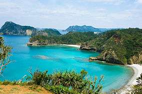
Ogasawara National Park (小笠原国立公園 Ogasawara Kokuritsu Kōen) is a national park in the Ogasawara Islands, located approximately one thousand kilometres to the south of Tokyo, Japan. The park was established in 1972 within the municipality of Ogasawara, itself part of Tokyo.[1][2][3] In 2011, the Ogasawara Islands were inscribed upon the UNESCO World Heritage List.[4]
Islands
The archipelago is also known as the Bonin Islands, a corruption of munin (無人), meaning 'uninhabited'.[5] The islands were returned to Japanese administration in 1968 after US Occupation.[5] The Chichijima, Hahajima, and Mukojima clusters are included within the park, but of the three Volcano Islands, Iwo Jima and Minami Iwo Jima are not.[1]
Flora and fauna
According to the IUCN evaluation for UNESCO, 441 taxa of native plants have been recorded, of which 161 of vascular plants and 88 of woody plants are endemic; the only native mammal is the critically endangered Bonin Flying Fox; of the 195 recorded species of birds, fourteen are on the IUCN Red List; of the two terrestrial reptiles, the Ogasawara Snake-Eyed Skink is endemic; of 1,380 insect species, 379 are endemic; of 134 species of lands snails, 100 are endemic. 40 species of freshwater fish, 23 of cetaceans, 795 of saltwater fish, and 226 of hermatypic coral have been recorded.[6]
See also
| Wikimedia Commons has media related to Bonin Islands. |
References
- 1 2 "Ogasawara National Park". Natural Parks Foundation. Retrieved 9 February 2012.
- ↑ "Introducing places of interest: Ogasawara National Park". Ministry of the Environment. Retrieved 9 February 2009.
- ↑ "Ogasawara National Park - Basic Information" (in Japanese). Ministry of the Environment. Retrieved 9 February 2009.
- ↑ "Ogasawara Islands". UNESCO. Retrieved 9 February 2009.
- 1 2 Sutherland, Mary; Britton, Dorothy (1995). National Parks of Japan. Kodansha. pp. 92–4. ISBN 4-7700-1971-8.
- ↑ "Ogasawara Islands - IUCN Technical Evaluation" (PDF). UNESCO. p. 62. Retrieved 9 February 2009.
External links
- Ogasawara National Park
- (Japanese) Ogasawara National Park
- Map of Ogasawara National Park (Chichi and Haha Islands)
- Map of Ogasawara National Park (Other islands)
Coordinates: 26°52′00″N 142°10′59″E / 26.8667°N 142.183°E