Kitakyūshū Quasi-National Park
| Kitakyūshū Quasi-National Park | |
|---|---|
| 北九州国定公園 | |
|
Hiraodai karst plateau | |
 Map of Japan | |
| Location | Fukuoka Prefecture, Japan |
| Nearest city | Nogata |
| Coordinates | 33°43′12″N 130°46′01″E / 33.72°N 130.767°ECoordinates: 33°43′12″N 130°46′01″E / 33.72°N 130.767°E[1] |
| Area | 82.49 km2 (31.85 sq mi) |
| Established | October 16, 1972 |
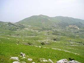
Kitakyūshū Quasi-National Park (北九州国定公園 Kitakyūshū Kokutei Kōen) is a Quasi-National Park in Fukuoka Prefecture, Japan.[2][3] It was founded on 16 October 1972 and has an area of 82.49 km2 (31.85 sq mi).[4]
See also
| Wikimedia Commons has media related to Kitakyūshū Quasi-National Park. |
References
- ↑ "Kita Kyushu Quasi National Park". protectedplanet.net.
- ↑ "北九州国定公園". Ministry of the Environment. Retrieved 10 May 2011.
- ↑ "石鎚/北九州/玄海/耶馬日田英彦山". National Parks Association of Japan. Retrieved 10 May 2011.
- ↑ "List of National Parks". Ministry of the Environment. Retrieved 10 May 2011.
This article is issued from Wikipedia - version of the 11/19/2016. The text is available under the Creative Commons Attribution/Share Alike but additional terms may apply for the media files.