Shiretoko National Park
| Shiretoko National Park | |
|---|---|
| 知床国立公園 | |
|
IUCN category II (national park) | |
|
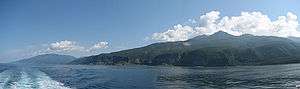
View from the sea | |
 Shiretoko National Park in Japan | |
| Location | Hokkaidō, Japan |
| Coordinates | 44°06′00″N 145°11′00″E / 44.10000°N 145.18333°ECoordinates: 44°06′00″N 145°11′00″E / 44.10000°N 145.18333°E |
| Area | 386.33 km² |
| Established | June 1, 1964 |
| Official name | Shiretoko |
| Type | Natural |
| Criteria | ix, x |
| Designated | 2005 (29th session) |
| Reference no. | 1193 |
| State Party | Japan |
| Region | Asia-Pacific |
Shiretoko National Park (知床国立公園 Shiretoko Kokuritsu Kōen) covers most of the Shiretoko Peninsula at the northeastern tip of the island of Hokkaidō, Japan. The word "Shiretoko" is derived from an Ainu word "sir etok", meaning "the place where the earth protrudes".
One of the most remote regions in all of Japan, much of the peninsula is only accessible on foot or by boat. The park is best known as the home of Japan's largest brown bear population and for offering views of Kunashiri Island, ownership of which Japan and Russia dispute. The park has a hot springs waterfall called Kamuiwakka Falls (カムイワッカの滝 Kamuiwakka-no-taki). Kamui wakka means "water of the gods" in Ainu.
The forests of the park are temperate and subalpine mixed forests; the main tree species include Sakhalin fir (Abies sachalinensis), Erman's birch (Betula ermanii) and Mongolian oak (Quercus mongolica). Beyond the forest limit there are impenetrable Siberian Dwarf Pine (Pinus pumila) thickets.
In 2005, UNESCO designated the area a World Heritage Site, advising to develop the property jointly with Kuril Islands of Russia as a transboundary "World Heritage Peace Park".
Features
See also
External links
- http://www.biodic.go.jp/english/jpark/np/siretoko_e.html
-
 Shiretoko National Park travel guide from Wikivoyage