Towada-Hachimantai National Park
| Towada-Hachimantai National Park | |
|---|---|
| 十和田八幡平国立公園 | |
|
IUCN category II (national park) | |
|
| |
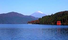
 Towada-Hachimantai National Park in Japan | |
| Location | Tōhoku, Japan |
| Coordinates | 40°43′59.88″N 140°43′1.2″E / 40.7333000°N 140.717000°ECoordinates: 40°43′59.88″N 140°43′1.2″E / 40.7333000°N 140.717000°E |
| Area | 854 square kilometres (330 sq mi) |
| Established | 1 February 1936 |
.jpg)
Towada-Hachimantai National Park (十和田八幡平国立公園 Towada-Hachimantai Kokuritsu Kōen) is a national park comprising two separate areas of Aomori, Iwate, and Akita Prefectures, Japan. The Towada-Hakkōda area encompasses Lake Towada, Mount Hakkōda, and most of the Oirase River valley. The Hachimantai area includes Mount Hachimantai, Mount Iwate, Tamagawa Onsen, and Akita Komagatake (秋田駒ヶ岳).[1][2][3] The two areas are 50 kilometres (31 mi) apart, and cover 854 square kilometres (330 sq mi).[4]
Related municipalities
- Aomori: Aomori, Hirakawa, Kuroishi, Towada[5]
- Iwate: Hachimantai, Shizukuishi, Takizawa[5]
- Akita: Kazuno, Kosaka, Semboku[5]
See also
| Wikimedia Commons has media related to Towada-Hachimantai National Park. |
References
- ↑ "Introducing places of interest: Towada-Hachimantai National Park". Ministry of the Environment. Retrieved 29 February 2012.
- ↑ "Towada-Hachimantai National Park". Natural Parks Foundation. Retrieved 29 February 2012.
- ↑ Sutherland, Mary; Britton, Dorothy (1995). National Parks of Japan. Kodansha. pp. 48–50. ISBN 4-7700-1971-8.
- ↑ "Towada-Hachimantai National Park". Encyclopedia of Japan. Tokyo: Shogakukan. 2012. OCLC 56431036. Retrieved 2012-08-13.
- 1 2 3 "Towada-Hachimantai National Park: basic information" (in Japanese). Ministry of the Environment. Retrieved 29 February 2012.
External links
- (English) Towada-Hachimantai National Park
- (English) Towada-Hachimantai National Park (JNTO)
- (Japanese) Towada-Hachimantai National Park
- Map of Towada-Hachimantai National Park (area 1)
- Map of Towada-Hachimantai National Park (area 2)
 Towada-Hachimantai National Park travel guide from Wikivoyage
This article is issued from Wikipedia - version of the 11/18/2016. The text is available under the Creative Commons Attribution/Share Alike but additional terms may apply for the media files.