Rishiri-Rebun-Sarobetsu National Park
| Rishiri-Rebun-Sarobetsu National Park | |
|---|---|
| 利尻礼文サロベツ国立公園 | |
|
IUCN category II (national park) | |
|
Rishiri Island | |
 | |
| Location | Hokkaidō, Japan |
| Nearest city | Wakkanai |
| Coordinates | 45°11′38″N 141°15′29″E / 45.1939°N 141.258°ECoordinates: 45°11′38″N 141°15′29″E / 45.1939°N 141.258°E |
| Area | 212.22 square kilometres (81.94 sq mi) |
| Established | September 20, 1974 |
Rishiri-Rebun-Sarobetsu National Park (利尻礼文サロベツ国立公園 Rishiri Rebun Sarobetsu Kokuritsu Kōen) is a national park on the Rishiri Island, Rebun Island, and a coastal area from Wakkanai to Horonobe at the north-western tip of Hokkaidō, Japan. Areas of the park cover 212.22 square kilometres (81.94 sq mi).[1][2][3] The park is noted for its alpine flora and views of volcanic mountains and areas formed by marine erosion.[2][3] The park is surrounded by fishing grounds, and the coastal areas of the park are rich in kelp.[1] The coastal areas of the national park can be accessed from Japan National Route 40, known as the Wakkanai National Highway, and the Rishiri and Rebun are accessible by ferry from Wakkanai.
Geography
Sarobetsu Plain
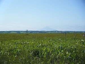
The Sarobetsu Plain (サロベツ原野 Sarobetsu Gen'ya) is a marshy floodplain on the Sea of Japan formed by the Teshio River and Sarobetsu River.[2] The plain is approximately 17 kilometres (11 mi) long and covers approximately 150 square kilometres (58 sq mi).[1] The Sarobetsu Plain has a subarctic climate and consists of large peat bogs.[4] The Sarobetsu Plain was added to the Ramsar List of Wetlands of International Importance in 2005 as part of the Ramsar Convention, an international treaty for the conservation of wetlands.[3]
Rishiri Island
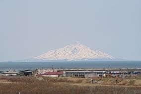
Rishiri Island (利尻島 Rishiri-tō), separated from Hokkaido by the Rishiri Channel, was formed by the cone-shaped extinct volcanic peak of Mount Rishiri (1,721 kilometres (1,069 mi)).[3] The island is 63 kilometres (39 mi) in circumference and covers 183 square kilometres (71 sq mi).[5]
Rebun Island
Rebun Island (礼文島 Rebun-tō) is approximately 30 kilometres (19 mi) west of Wakkanai in Hokkaido. The island is 72 kilometres (45 mi) in circumference and covers 82 square kilometres (32 sq mi). Rebun reaches its highest altitude at Rebundake.[1][6]
See also
References
- 1 2 3 4 "Rishiri-Rebun-Sarobetsu National Park". Encyclopedia of Japan. Tokyo: Shogakukan. 2012. OCLC 56431036. Retrieved 2012-06-03.
- 1 2 3 "利尻礼文サロベツ国立公園" [Rishiri-Rebun-Sarobetsu National Park]. Dijitaru daijisen (in Japanese). Tokyo: Shogakukan. 2012. OCLC 56431036. Retrieved 2012-06-03.
- 1 2 3 4 "利尻礼文サロベツ国立公園" [Rishiri-Rebun-Sarobetsu National Park]. Nihon Daihyakka Zensho (Nipponika) (in Japanese). Tokyo: Shogakukan. 2012. OCLC 153301537. Retrieved 2012-06-02.
- ↑ "Sarobetsu Plain". Encyclopedia of Japan. Tokyo: Shogakukan. 2012. OCLC 56431036. Retrieved 2012-06-03.
- ↑ "Rishiri". Encyclopedia of Japan. Tokyo: Shogakukan. 2012. OCLC 56431036. Retrieved 2012-06-03.
- ↑ "Rebun". Encyclopedia of Japan. Tokyo: Shogakukan. 2012. OCLC 56431036. Retrieved 2012-06-03.
External links
- http://www.biodic.go.jp/english/jpark/np/risiri_e.html
-
 Rishiri-Rebun-Sarobetsu National Park travel guide from Wikivoyage