Mikawa-wan Quasi-National Park
| Mikawa Wan Quasi-National Park | |
|---|---|
| 三河湾国定公園 | |
|
IUCN category V (protected landscape/seascape) | |
|
Cape Irago | |
 Mikawa Wan Quasi-National Park in Japan | |
| Location | Aichi Prefecture, Japan |
| Coordinates | 34°36′59″N 137°8′49″E / 34.61639°N 137.14694°ECoordinates: 34°36′59″N 137°8′49″E / 34.61639°N 137.14694°E |
| Area | 94.43 km² |
| Established | April 10, 1958 |
| Governing body | Aichi Prefecture [1] |

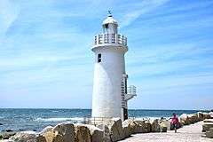
Cape Irago Lighthouse
Mikawa-wan Quasi-National Park (三河湾国定公園 Mikawa-wan Kokutei Kōen) is a Quasi-National Park in Aichi Prefecture, Japan.[2][3] It is rated a protected landscape (category V) according to the IUCN.[4] The park includes the coastal areas of Atsumi Peninsula, the Pacific shoreline of Chita Peninsula as well as islands and portion of the northern shoreline of Mikawa Bay.[5]
It was founded on 10 April 1958 and has an area of 94.4 km².[6]
Like all Quasi-National Parks in Japan, the park is managed by the local prefectural governments.[1]
| Wikimedia Commons has media related to Mikawawan Quasi-National Park. |
See also
References
- Southerland, Mary and Britton, Dorothy. The National Parks of Japan. Kodansha International (1995). ISBN 4-7700-1971-8
- 1 2 "National Park systems: Definition of National Parks". National Parks of Japan. Ministry of the Environment of the Government of Japan. Retrieved 2008-08-29.
- ↑ "三河湾国定公園". Ministry of the Environment. Retrieved 10 May 2011.
- ↑ "三河湾/鈴鹿/室生赤目青山/琵琶湖". National Parks Association of Japan. Retrieved 10 May 2011.
- ↑ MPA Global Database
- ↑ "Mikawa Wan Quasi National Park". World Database on Protected Areas. United Nations Environment Programme, World Conservation Monitoring Center.
- ↑ "List of National Parks". Ministry of the Environment. Retrieved 10 May 2011.
This article is issued from Wikipedia - version of the 11/19/2016. The text is available under the Creative Commons Attribution/Share Alike but additional terms may apply for the media files.