Shokanbetsu-Teuri-Yagishiri Quasi-National Park
| Shokanbetsu-Teuri-Yagishiri Quasi-National Park | |
|---|---|
| 暑寒別天売焼尻国定公園 | |
|
IUCN category V (protected landscape/seascape) | |
|
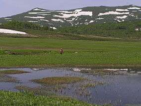
Uryū wetlands and Mashike Mountains (July 2006) | |
 Shokanbetsu-Teuri-Yagishiri Quasi-National Park in Japan | |
| Location | Hokkaidō, Japan |
| Nearest city | Haboro, Hokuryū, Ishikari, Mashike, Shintotsukawa, Uryū |
| Coordinates | 43°N 141°E / 43°N 141°ECoordinates: 43°N 141°E / 43°N 141°E |
| Area | 435.59 square kilometres (168.18 sq mi) [1] |
| Established | August 1, 1990[1] |
Shokanbetsu-Teuri-Yagishiri Quasi-National Park (暑寒別天売焼尻国定公園 Shokanbetsu-Teuri-Yagishiri Kokutei Kōen) is a quasi-national park in Hokkaidō, Japan.[1]
The park include the following areas:
See also
References
- 1 2 3 List of Quasi-National Parks, Ministry of the Environment Government of Japan , Last access 9 June 2009
This article is issued from Wikipedia - version of the 11/19/2016. The text is available under the Creative Commons Attribution/Share Alike but additional terms may apply for the media files.