Mitchell Caverns
| Mitchell Caverns | |
|---|---|
 | |
  | |
| Location | San Bernardino County, California, United States |
| Coordinates | 34°56′27″N 115°30′52″W / 34.9408247°N 115.5144356°WCoordinates: 34°56′27″N 115°30′52″W / 34.9408247°N 115.5144356°W[1] |
| Elevation | 4,300 feet (1,300 m) |
| Geology | Solutional cave |
| Access | Show cave, closed |
| Designated | 1975 |
The Mitchell's Caverns, within the Mitchell Caverns Natural Preserve, are a trio of limestone caves, located on the east side of the Providence Mountains at an elevation of 4,300 feet (1,300 m), within the Providence Mountains State Recreation Area. They are located in the Mojave Desert, at the north-western end of Essex Road, off of Interstate 40 (Needles Freeway) in San Bernardino County, California.
Geology
The caverns were created during the Pleistocene epoch, when ground water with a high carbonic acid content ate into the surrounding marble and sedimentary limestone. Stalactites, stalagmites, and other cave formations were formed from calcium carbonate left by dripping mineral water. For many years the caves were thought to be "dead", that is, the formations were no longer growing. However, recent studies have found some signs of life.
History
Numerous paleontological and archaeological finds have been made in and around the caverns. Scientists have found the remains of several prehistoric animals, including a sloth. The caverns were a sacred place for the Chemehuevi Indians, and a number of tools and fire pits have been found. The Chemihuevi knew the caves as "the eyes of the mountain" due to their easily spotted dual entrances located near the top of the mountain.
The caverns are named after Jack Mitchell, who owned and operated the caves from 1934 to 1954 as a tourist attraction and rest stop for travelers on nearby U.S. Route 66. Mitchell also held mining rights to the area and dug several prospect holes and tunnels, some of which are still visible.
The area became a state recreation area in 1956. The surrounding lands became a part of the National Park Service Mojave National Preserve in 1994, but the caves are still owned and operated by the state.
Cavern tours
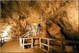
The "Tecopa" (named for a Shoshone Indian chief) and "El Pakiva" (Devil's house) caves are connected by a man-made tunnel and were open to guided tours led by California State Park rangers. The "Winding Stair" cave is considered dangerous and is closed to the public, though it is occasionally used for training cave rescue teams. These caves are the only limestone caves in the California State Park system.
Due to California's budget crisis all tours have been suspended and the Providence Mountains SRA closed in May 2011,.[2] Vandalism has plagued the caverns' visitor center and installations since their closure.[3]
See also
References
- ↑ "Mitchell Caverns Natural Preserve". Geographic Names Information System. United States Geological Survey. Retrieved 2012-12-16.
- ↑ "Providence Mountains State Recreation Area". California Department of Parks and Recreation.
- ↑ Louis Sahagun (February 25, 2012). "Shuttered California state parks may be vulnerable to vandalism". Los Angeles Times. Retrieved 2012-05-05.
- http://Desertusa.com - Mitchell Caverns article.
- Robert P. Sharp and Allen F. Glazner, Geology Underfoot in Southern California, Missoula Mont: Mountain Press, 1993.
External links
- Official Mitchell Caverns Natural Preserve website
- Mitchell Caverns Preserve Map
- Official Providence Mountains State Recreation Area website
- Mitchell Caverns Geology
- Committee to Reopen Mitchell Caverns non-profit website