Cayucos State Beach
| Cayucos State Beach | |
|---|---|
  | |
| Location | San Luis Obispo County, California, USA |
| Nearest city | Cayucos, California |
| Coordinates | 35°26′51″N 120°54′15″W / 35.44750°N 120.90417°W / 35.44750; -120.90417Coordinates: 35°26′51″N 120°54′15″W / 35.44750°N 120.90417°W / 35.44750; -120.90417 |
| Area | 16 acres (6.5 ha) |
| Established | 1940 |
| Governing body | California Department of Parks and Recreation |
Cayucos State Beach is a protected beach in the state park system of California, United States. It is located in Cayucos, San Luis Obispo County. The sandy beach environment supports uses of swimming and surfing.[1] Prehistorically this general area of the central coast was inhabited by the Chumash people, who settled the coastal San Luis Obispo area approximately 10,000 to 11,000 BCE, including a large village to the south of Cayucos at Morro Creek.[2] The 16-acre (6.5 ha) park was established in 1940.[3]

Cayucos State Beach at Sunset
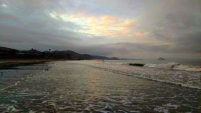
Cayucos State Beach at Sunrise
See also
References
- ↑ "Cayucos SB". California State Parks. Retrieved 2010-05-28.
- ↑ Hogan, C. Michael (2008-02-25). Burnham, A., ed. "Morro Creek". The Megalithic Portal.
- ↑ "California State Park System Statistical Report: Fiscal Year 2009/10" (PDF). California State Parks: 30. Retrieved 2011-10-29.
External links
| Wikimedia Commons has media related to Cayucos State Beach. |
This article is issued from Wikipedia - version of the 11/19/2016. The text is available under the Creative Commons Attribution/Share Alike but additional terms may apply for the media files.