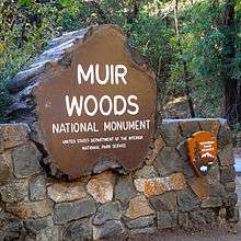
Muir Woods National Monument
| Muir Woods National Monument | |
|---|---|
|
IUCN category V (protected landscape/seascape) | |
|
| |
 | |
| Location | Marin County, California, United States |
| Nearest city | Mill Valley, CA |
| Coordinates | 37°53′31″N 122°34′15″W / 37.89194°N 122.57083°WCoordinates: 37°53′31″N 122°34′15″W / 37.89194°N 122.57083°W |
| Area | 554 acres (224 ha)[1] |
| Created | January 9, 1908 |
| Visitors | 897,131 (in 2011)[2] |
| Governing body | National Park Service |
| Website | Muir Woods National Monument |
| Designated | January 09, 2008 |
| Reference no. | 07001396[3] |
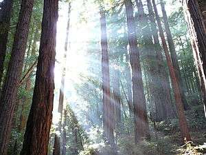
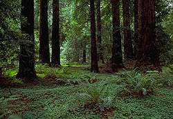
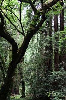
Muir Woods National Monument is a unit of the National Park Service on Mount Tamalpais near the Pacific coast, in southwestern Marin County, California. It is part of the Golden Gate National Recreation Area, and is 12 miles (19 km) north of San Francisco. It protects 554 acres (224 ha),[4] of which 240 acres (97 ha) are old growth coast redwood (Sequoia sempervirens) forests,[5] one of a few such stands remaining in the San Francisco Bay Area.
Geography
Ecosystem
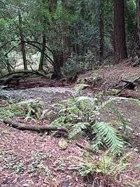
The Muir Woods National Monument is an old-growth coastal redwood forest. Due to its proximity to the Pacific Ocean, the forest is regularly shrouded in a coastal marine layer fog, contributing to a wet environment that encourages vigorous plant growth. The fog is also vital for the growth of the redwoods as they use moisture from the fog during droughty seasons, in particular the dry summer.
Climate
The monument is cool and moist year round with average daytime temperatures between 40 and 70 degrees Fahrenheit (4 to 21 °C). Rainfall is heavy during the winter and summers are almost completely dry with the exception of fog drip caused by the fog passing through the trees. Annual precipitation in the park ranges from 39.4 inches (1,000 mm) in the lower valley to 47.2 inches (1,200 mm) higher up in the mountain slopes.
Soils and bedrock
The redwoods grow on brown humus-rich loam which may be gravelly, stony or somewhat sandy. This soil has been assigned to the Centissima series, which is always found on sloping ground. It is well drained, moderately deep, and slightly to moderately acidic.[6] It has developed from a mélange in the Franciscan Formation.[7] More open areas of the park have shallow gravelly loam of the Barnabe series, or deep hard loam of the Cronkhite series.[8]
History
.JPG)
One hundred and fifty million years ago ancestors of redwood and sequoia trees grew throughout the United States. Today, the Sequoia sempervirens can be found only in a narrow, cool coastal belt from Monterey, California, in the south to Oregon in the north.
Before the logging industry came to California, there were an estimated 2 million acres (8,000 km2) of old growth forest containing redwoods growing in a narrow strip along the coast.
By the early 20th century, most of these forests had been cut down. Just north of the San Francisco Bay, one valley named Redwood Canyon remained uncut, mainly due to its relative inaccessibility.
This was noticed by U.S. Congressman William Kent. He and his wife, Elizabeth Thacher Kent, purchased 611 acres (247 ha) of land from the Tamalpais Land and Water Company for $45,000 with the goal of protecting the redwoods and the mountain above them.
In 1907, a water company in nearby Sausalito planned to dam Redwood Creek, thereby flooding the valley. When Kent objected to the plan, the water company threatened to use eminent domain and took him to court to attempt to force the project to move ahead. Kent sidestepped the water company's plot by donating 295 acres (119 ha) of the redwood forest to the federal government, thus bypassing the local courts.
On January 9, 1908, President Theodore Roosevelt declared the land a National Monument, the first to be created from land donated by a private individual. The original suggested name of the monument was the Kent Monument but Kent insisted the monument be named after naturalist John Muir, whose environmental campaigns helped to establish the National Park system. President Roosevelt agreed, writing back:
- MY DEAR MR. KENT: By George! you are right.
and, responding to some photographs of Muir Woods that Mr. Kent had sent him,
- Those are awfully good photos.[9]
Kent and Muir had become friends over shared views of wilderness preservation, but Kent's later support for the flooding of Hetch Hetchy caused Muir to end their friendship.[10]
In December 1928, the Kent Memorial was erected at the Kent Tree in Fern Canyon. This tree—a Douglas fir, not a redwood—was said to be Kent's favorite. Due to its height of 280 feet (85 m) and location on a slope, the tree leaned towards the valley for more than 100 years. Storms in El Niño years of 1981 and 1982 caused the tree to tilt even more and took out the top 40 feet (12 m) of the tree.[11] During the winter of 2002–03, many storms brought high winds to Muir Woods causing the tree to lean so much that a fissure developed in January 2003. This fissure grew larger as the tree slowly leaned more and more, forcing the closure of some trails. On March 18, 2003, at around 8:28 pm, the tree fell, damaging several other trees nearby.[11] The closed trails have since been reconfigured and reopened.
In 1937, the Golden Gate Bridge was completed and park attendance tripled, reaching over 180,000. Muir Woods is one of the major tourist attractions of the San Francisco Bay Area, with 776,000 visitors in 2005.
President Franklin Delano Roosevelt died on April 12, 1945, shortly before he was to have opened the United Nations Conference on International Organization for which delegates from 50 countries met in San Francisco to draft and sign the United Nations Charter. On May 19, the delegates held a commemorative ceremony in tribute to his memory in Muir Woods' Cathedral Grove, where a dedication plaque was placed in his honor.
The monument was listed on the National Register of Historic Places on January 9, 2008.[12]
Biology
Flora
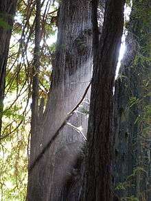
The main attraction of Muir Woods are the coast redwood (Sequoia sempervirens) trees. They are known for their height, and are related to the giant sequoia of the Sierra Nevada. While redwoods can grow to nearly 380 feet (115 m), the tallest tree in the Muir Woods is 258 feet (79 m). The trees come from a seed no bigger than that of a tomato.[13] Most of the redwoods in the monument are between 500 and 800 years old. The oldest is at least 1,200 years old.
Other tree species grow in the understory of the redwood groves. Three of the most common are the California bay laurel, the bigleaf maple and the tanoak. Each of these species has developed a unique adaptation to the low level of dappled sunlight that reaches them through the redwoods overhead. The California bay laurel has a strong root system that allows the tree to lean towards openings in the canopy. The bigleaf maple, true to its name, has developed the largest leaf of any maple species allowing it to capture more of the dim light. The tanoak has a unique internal leaf structure that enables it to make effective use of the light that filters through the canopy.
Fish
Redwood Creek provides a critical spawning and rearing habitat for coho or silver salmon (Oncorhynchus kisutch) and steelhead (Oncorhynchus mykiss). Steelhead are listed as threatened species (2011) in the Central California Coast distinct population segment. Coho salmon are listed as endangered in their evolutionary significant unit (2011). The creek is near the southernmost limit of coho habitat and the fish have never been stocked, so they have a distinctive DNA. The Redwood Creek salmon are Central Coast coho salmon which have been listed as federally threatened species since October 2006 and as federally endangered species in June 2005. Coho migrate from the ocean back to freshwater for a single chance at reproduction, generally after two years in the ocean. The spawning migrations begin after heavy late fall or winter rains breach the sandbar at Muir Beach allowing the fish to move upstream (usually in December and January).[14] No salmon were seen in the 2007–2008 winter run, nor the 2008–2009 winter run. Evidence points to exhaustion of smolt oversummering in the creek due to a loss of large woody debris and deep pools where young salmon can rest. Starting in 2009, the National Park Service began restoring Muir Beach to create a functional, self-sustaining ecosystem and improve visitor access.[15] The intervention was almost too late, since the coho only has a three-year life span. But, as of January 2010, and for the first time in three years, an estimated 45 coho swam up Redwood Creek to spawn, creating 23 redds or clusters of eggs.[16] In 2011, 11 live adult coho and 1 coho carcass was observed, along with three redds, a modest increase over the 2007-2008 spawning season.[17] Statewide the coho population is 1% of its levels in the 1940s and the fish have vanished from 90% of the streams they formerly visited.[18][19] The Watershed Alliance of Marin reported that no salmon returned to spawn in 2014, prompting concerns that the fish may now be extirpated from the creek.[20]
Birds
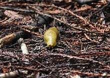
Muir Woods is home to over 50 species of birds.[21] This relatively low number is due to the lack of insects. The tannin in the trees repels the insects and the volume of flowers and fruits produced by plants below the canopy is limited by the shade of the redwoods.
It is occasionally possible to see northern spotted owls or pileated woodpeckers in the forest. While decreasing in numbers elsewhere, the spotted owls appear to be thriving in the monument and other evergreen forests in the area. A National Park Service monitoring project of the owls is ongoing within the monument. The project has found that adult owls are finding mates, raising young to adulthood and the young are having new broods of their own.
Mammals
The monument is home to a variety of mammals ranging in size from the American shrew mole to much larger deer. The majority of the mammals are not seen as they are nocturnal or are burrowing animals living under the ground or the dense litter on the forest floor. Most commonly seen are Sonoma chipmunks, and western gray squirrels.[22]
Bears historically roamed the area but were largely exterminated by habitat destruction. In 2003 a male black bear was spotted wandering in various areas of Marin County, including Muir Woods.
There are 11 species of bats that call the monument home, often using hollows burned into the redwoods by past fires as a maternity colony.
In November 2010 sea otters (Enhydra lutris) have been spotted swimming in the new stream channel constructed in the lagoon area of Redwood Creek.[16]
Recreation
Muir Woods, part of the Golden Gate National Recreation Area, is a park which caters to pedestrians, as parking of vehicles is only allowed at the very entrance. Hiking trails vary in the level of difficulty and distance. Picnicking, camping and pets are not permitted.
As of 2015, the park sees up to 6000 visitors per day during peak times (April to October, Thanksgiving weekend, and Christmas through New Years), more than 80% of which arrive by car, and most of the rest with a tour bus or shuttle bus.[23] Currently, parking is extremely limited and lots often fill early in the day.[24] The county and the National Park Service plan to introduce a reservation system that by 2017 will restrict the number of vehicles allowed to enter and park in Muir Woods every day.[23] Residents of neighboring Mill Valley had protested against earlier plans to set up an additional parking lot, and together with a group named "Mount Tam Task Force" sued to prevent the building of a shuttle bus station.[23]
Facilities
Lodging and camping
There are no camping or lodging facilities in the Muir Woods. The monument is a day-use area only. There are camping facilities in the adjacent Mount Tamalpais State Park.
Comfort facilities
- Restrooms located in entrance plaza and cafe
- Muir Woods Trading Company cafe and gift shop – offers deli food items and souvenirs. The cafe also has a permanent display of historic photographs.
- The main trail (paved and boardwalk) through Muir Woods is a 2 miles (3.2 km) loop. A .5 miles (0.80 km) loop from the Visitor Center, through Founders Grove, to Bridge 2 and back is ADA accessible.
Interpretive facilities
- The Visitor Center, located in the entrance plaza, features permanent and changing exhibits on redwood ecology and conservation, as well as a store selling books and gift items.
Activities
Hiking and biking

The paved/boardwalk main trail begins at the entrance plaza (Trail Map) and travels into the old growth redwood forest alongside Redwood Creek. Other unpaved walking trails extend from the main trail to connect with Mt. Tamalpais State Park trails outside of the monument boundaries.[25]
Bicycles are only allowed on designated fire roads.
Athletic events
The annual Dipsea Race, a footrace which goes between Mill Valley and Stinson Beach, passes through Muir Woods on the second Sunday in June. The Double Dipsea, later in June and the Quad Dipsea, in November, follow the same course.
Ranger-led activities

Rangers and volunteers present 15-minute interpretive talks and guided one-hour tours when staffing permits. Program topics include redwood ecology and conservation, the impact of climate change, and the history of Muir Woods. Longer hikes or other special programs are offered several times per month, and require a reservation.[26]
Weddings and Special Events
Weddings, commercial filming, and special events are allowed in the monument only with a proper permit.[27]
Music
Japanese composer Toru Takemitsu composed a three movement solo classical guitar piece called "In the Woods" in 1995. The third movement of the piece is called Muir Woods and it was inspired in this forest.
In fiction
Characters played by James Stewart and Kim Novak visit the Muir Woods National Monument in Alfred Hitchcock's 1958 film Vertigo; however, the scene was actually shot in Big Basin Redwoods State Park.[28] The monument was a setting in both Rise of the Planet of the Apes (2011) and Dawn of the Planet of the Apes (2014), though both films were in fact filmed in British Columbia.[29][30]
References
- ↑ "Listing of acreage as of December 31, 2011". Land Resource Division, National Park Service. Retrieved 2012-03-23.
- ↑ "NPS Annual Recreation Visits Report". National Park Service. Retrieved 2012-03-23.
- ↑ National Park Service (2010-07-09). "National Register Information System". National Register of Historic Places. National Park Service.
- ↑ "Muir Woods Tour Manual – 2008" (PDF). National Park Service. Retrieved 2009-01-19.
- ↑ Bolsinger, Charles L.; Waddell, Karen L. (1993). "Area of old-growth forests in California, Oregon, and Washington" (PDF). United States Forest Service, Pacific Northwest Research Station. Resource Bulletin PNW-RB-197.
- ↑ Official Series Description - CENTISSIMA Series. Soilseries.sc.egov.usda.gov. Retrieved on 2013-07-21.
- ↑ http://ngmdb.usgs.gov/ngm-bin/pdp/zui_viewer.pl?id=10424
- ↑ http://casoilresource.lawr.ucdavis.edu/gmap/
- ↑ Muir Woods (1930), includes letters to and from President Roosevelt
- ↑ William Kent - People - John Muir Exhibit. Sierraclub.org (1976-04-05). Retrieved on 2013-07-21.
- 1 2 "Kent Tree Falls". Natural Resources at Muir Woods NM. 2003. Archived from the original on 2006-12-23. Retrieved 2015-07-11.
- ↑ National Park Service (2009-03-13). "National Register Information System". National Register of Historic Places. National Park Service.
- ↑ Muir Woods National Monument - Muir Woods National Monument. Nps.gov (2013-06-23). Retrieved on 2013-07-21.
- ↑ Carlisle, S., M. Reichmuth, E. Brown, and S. C. Del Real (2008). Long-term coho salmon and steelhead trout monitoring in coastal Marin County 2007: annual monitoring progress report. Natural Resource Technical Report NPS/SFAN/NRTR—2009/269 (PDF) (Report). Fort Collins, Colorado: National Park Service. Retrieved Jan 5, 2010.
- ↑ Michelle O’Herron (August 2009). "Coho Salmon Monitoring in Redwood Creek, Inventory and Monitoring Program Research Project Summary" (PDF). National Park Service. Retrieved Jan 5, 2009.
- 1 2 Peter Fimrite (2010-11-12). "Marin creek being restored to bring back coho". San Francisco Chronicle. Retrieved 2010-11-14.
- ↑ 2010-2011 Coho and Steelhead Spawner Survey Summary (Report). National Park Service. Retrieved 2011-05-15.
- ↑ Mark Prado (Jan 2, 2010). "Marin's coho salmon on the brink of extinction". Marin Independent Journal. Retrieved Jan 12, 2010.
- ↑ Donna Whitmarsh (Jan 2010). "California Coho Salmon In Dire Straits, New Report Predicts Collapse". Bay Nature. Retrieved Jan 12, 2010.
- ↑ "Muir Woods coho salmon vanish, fanning fears of extinction", San Francisco Chronicle, November 29, 2014
- ↑ The Birds of Muir Woods National Monument. Muir Woods National Monument – Birds, U.S. National Park Service. Last updated on September 2001. Accessed 2010-08-09.
- ↑ Muir Woods National Monument (Official Map & Guide). National Park Service. Retrieved 2010-06-29.
- 1 2 3 Nolte, Carl (2015-07-10). "Wildly popular Muir Woods to start requiring reservations". San Francisco Chronicle. Retrieved 2015-07-11.
- ↑ "Muir Woods National Monument". National Park Service. Retrieved 2016-01-01.
- ↑ http://www.nps.gov/muwo/planyourvisit/hiking-trails.htm
- ↑ "Things To Do - Muir Woods National Monument (U.S. National Park Service)". www.nps.gov. Retrieved 2016-11-11.
- ↑ http://www.nps.gov/goga/planyourvisit/specialparkuses.htm
- ↑ Watkins, Charles (2014). Trees, Woods and Forests: A Social and Cultural History. Reaktion Books. p. 225. ISBN 1780234155.
- ↑ http://www.imdb.com/title/tt1318514/locations
- ↑ http://www.imdb.com/title/tt2103281/locations
External links
| Wikimedia Commons has media related to Muir Woods National Monument. |
- NPS page for Muir Woods (includes "Plan your visit")
- Web Soil Survey (select Marin County)
- Muir Woods Guide