Bean Hollow State Beach
| Bean Hollow State Beach | |
|---|---|
 | |
  | |
| Location | San Mateo County, California, USA |
| Nearest city | Pescadero, California |
| Coordinates | 37°13′33″N 122°24′32″W / 37.22583°N 122.40889°W / 37.22583; -122.40889Coordinates: 37°13′33″N 122°24′32″W / 37.22583°N 122.40889°W / 37.22583; -122.40889 |
| Area | 44 acres (18 ha) |
| Established | 1958 |
| Governing body | California Department of Parks and Recreation |
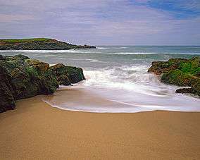
Bean Hollow State Beach is a beach in the state park system of California, USA. It is located in San Mateo County near Pescadero. The beach offers fishing, picnicking and beachcombing. Visitors can explore tide pools with anemones, crab, sea urchins and other marine inhabitants. The beach also has a self-guided nature trail. Swimming is dangerous because of cold water, rip currents, heavy surf and sharks. Bean Hollow is 17.5 miles (28.2 km) south of Half Moon Bay and 3 miles (4.8 km) south of Pescadero on State Route 1.[1] The 44-acre (18 ha) property was acquired by the state in 1958.[2]
Name
Named after Cañada del Frijol which was applied in the 1840s. The English term was in use by 1861.[3]
See also
References
- ↑ "Bean Hollow SB". California State Parks. Archived from the original on 28 May 2010. Retrieved 2010-05-28.
- ↑ "California State Park System Statistical Report: Fiscal Year 2009/10" (PDF). California State Parks: 30. Retrieved 2011-09-24.
- ↑ Gudde, Erwin G. (1998). California place names : the origin and etymology of current geographical names (4th ed., rev. and enl. ed.). Berkeley: University of California Press. p. 29. ISBN 0520213165.
External links
This article is issued from Wikipedia - version of the 11/19/2016. The text is available under the Creative Commons Attribution/Share Alike but additional terms may apply for the media files.