El Paso Mountains Wilderness
| El Paso Mountains Wilderness | |
|---|---|
|
IUCN category Ib (wilderness area) | |
|
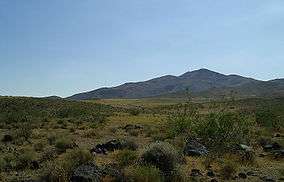
El Paso Mountains | |
 | |
| Location | Kern County, California, USA |
| Nearest city | Ridgecrest, CA |
| Coordinates | 35°28′00″N 117°50′00″W / 35.46667°N 117.83333°W / 35.46667; -117.83333Coordinates: 35°28′00″N 117°50′00″W / 35.46667°N 117.83333°W / 35.46667; -117.83333 |
| Area | 23,780 acres (96 km2) |
| Established | October 31, 1994 |
| Governing body | U.S. Bureau of Land Management |
The El Paso Mountains Wilderness was created in 1994 and now has a total of 23,780 acres (96.2 km2). All of the wilderness is in the northern Mojave Desert in eastern Kern County, California and is managed by the Bureau of Land Management. It is located south of Ridgecrest, California.
Geography
The Wilderness contains numerous reddish-colored buttes and dark, uplifted volcanic mesas dissected by narrow canyons. The highest point and central feature of this wilderness is Black Mountain, 5,244 feet (1,598 m), an extinct volcano. Surrounding the mountain is a badlands topography.
Flora and fauna
The most spectacular attribute of this area is the abundance of cultural sites. The southern portion of the wilderness is included in the Last Chance Archaeological District and is listed on the National Register of Historic Places. Wildlife includes raptors, Mohave Ground Squirrel, and the Desert Tortoise. Vegetation primarily consists of creosote bush scrub community with Joshua trees on the western side of the mountain.

See also
- Protected areas of the Mojave Desert
- Category: Flora of the California desert regions
- Category: Fauna of the Mojave Desert
References
- BLM−Bureau of Land Management: Official El Paso Mountains Wilderness website
- Wilderness.net: El Paso Mountains Wilderness
- Adventuring in the California Desert; Lynne Foster; Sierra Club Books; 1987; (ISBN 0-87156-721-0)