Kenai, Alaska
| Kenai Shk'ituk't | |
|---|---|
| City | |
|
Aerial view of part of downtown Kenai. The intersection of Willow Street and Barnacle Way is in the center of the foreground. Cook Inlet and Mount Redoubt are in the background. | |
| Motto: "Village with a Past - City with a Future" | |
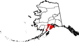
 Location of Kenai, Alaska | |
| Coordinates: 60°33′31″N 151°13′47″W / 60.55861°N 151.22972°WCoordinates: 60°33′31″N 151°13′47″W / 60.55861°N 151.22972°W | |
| Country | United States |
| State | Alaska |
| Borough | Kenai Peninsula |
| Incorporated | May 10, 1960[1] |
| Government | |
| • Mayor | Patricia "Pat" Porter[2] |
| • State senator | Peter Micciche (R) |
| • State rep. | Kurt Olson (R) |
| Area | |
| • Total | 35.5 sq mi (92.0 km2) |
| • Land | 29.9 sq mi (77.4 km2) |
| • Water | 5.6 sq mi (14.6 km2) |
| Elevation | 72 ft (22 m) |
| Population (2010)[3] | |
| • Total | 7,100 Ranked 7th |
| Time zone | Alaska (AKST) (UTC-9) |
| • Summer (DST) | AKDT (UTC-8) |
| ZIP codes | 99611, 99635 |
| Area code | 907 |
| FIPS code | 02-38420 |
| GNIS feature ID | 1413299, 2419407 |
| Website |
www |

Kenai (/ˈkiːnaɪ/, KEY-nigh) (Dena'ina: Shk'ituk't) is a city in the Kenai Peninsula Borough in the U.S. state of Alaska.[3][4] The population was 7,100 as of the 2010 census.[3]
History
Etymology
The city of Kenai is named after the local Dena'ina (Tanaina) word 'ken' or 'kena', which means 'flat, meadow, open area with few trees; base, low ridge', according to the Dena'ina Topical Dictionary by James Kari, Ph.D., published in 2007. This describes the area along the mouth and portion of the Kenai River near the City of Kenai.
Prehistory and Russian era
Archaeological evidence suggests that the area was first occupied by the Kachemak people from 1000 B.C., until they were displaced by the Dena'ina Athabaskan people around 1000 A.D. Before the arrival of the Russians, Kenai was a Dena'ina village called Shk'ituk't, meaning "where we slide down." When Russian fur traders first arrived in 1741, about 1,000 Dena'ina lived in the village. The traders called the people "Kenaitze", which is a Russian term for "people of the flats", or "Kenai people". This name was later adopted when they were incorporated as the Kenaitze Indian Tribe in the early 1970s.
In 1786, Pytor Zaikov built Fort Nikolaevskaia for the Lebedev-Lastochkin Company on the site of modern Kenai, being the first European settlement on the Alaskan mainland.[5] Hostilities surfaced between the natives and settlers in 1797, culminating in an incident in which the Dena'ina attacked Fort St. Nicholas, later dubbed the battle of Kenai. Over one hundred deaths occurred from all involved parties. Later, in 1838, the introduction of smallpox killed one half of the Dena'ina population.
American era before statehood
In 1869, after the Alaska Purchase, the United States Army established a post called Fort Kenay. It was soon abandoned.
In 1888 a prospector named Alexander King discovered gold on the Kenai Peninsula. The amount of gold was small compared to the later gold finds in the Klondike, Nome and Fairbanks.
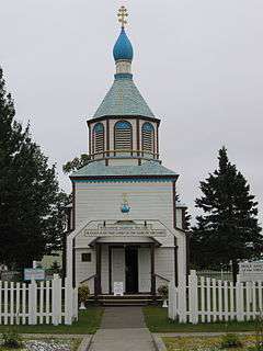
In 1895-96, the Holy Assumption of the Virgin Mary Russian Orthodox Church was built in the village.[6] It is still in use today.
The establishment of shipping companies in the early 1900s broadened Kenai into a port city. Canning companies were established and helped fuel the commercial fishing boom that was the primary activity through the 1920s.
In 1937, construction of the Kenai Airport began.
In 1940, homesteads were opened in the area. The first dirt road from Anchorage was constructed in 1951; pavement would not arrive until 1956 with the construction of the Kenai Spur Highway.
A military base, Wildwood Army Station (later Wildwood Air Force Station), was established in 1953, and served as a major communications post. Wildwood was conveyed in 1974 to the Kenai Native Association in partial settlement of Alaska Native land claims. The facility was leased and later purchased by the State of Alaska and presently serves as the Wildwood Correctional Complex.[7][8]
Modern era under statehood
In 1965, offshore oil discoveries in Cook Inlet caused a period of rapid growth. They were a part of a series of oil deposits located during the middle of the 20th century. In 1957, oil was discovered at Swanson River, 20 miles (32 km) northeast of Kenai. This was the first major oil discovery in Alaska.[9]
In 1992 and 2011, Kenai was named one of the All-America Cities.
In 2008, the Kenai River was designated as a Category 5, or “impaired,” water body by the State of Alaska in accordance with the federal Clean Water Act. The Kenai River Working Group (KRWG) was formed to address the issue of water pollution. By 2010, the status of the river was changed to a Category 2, or “water that attains its designated uses.”[10]
Geography
Kenai is located at 60°33′31″N 151°13′47″W / 60.55861°N 151.22972°W (60.558738, −151.229616),[11] on the west side of the Kenai Peninsula near the outlet of the Kenai River to the Cook Inlet of the Pacific Ocean. According to the United States Census Bureau, the city has a total area of 35.5 square miles (92 km2), of which, 29.9 square miles (77 km2) of it is land and 5.6 square miles (15 km2) of it (15.85%) is water.
Climate
As with much of Southcentral Alaska, Kenai has a moderate subarctic climate (Köppen Dfc) due to the cool summers. Winters are snowy, long but not particularly cold, especially considering the latitude, with January featuring a daily average temperature of 15.8 °F (−9.0 °C). Snow averages 63.6 inches (162 cm) per season, falling primarily from October thru March, with some accumulation in April, and rarely in May or September. There are 37 nights of sub-0 °F (−18 °C) lows annually, and the area lies in USDA Plant Hardiness Zone 4,[12] indicating an average annual minimum in the −20 to −30 °F (−29 to −34 °C) range. Summers are cool due to the marine influence, with 75 °F (24 °C)+ highs or 55 °F (13 °C)+ lows being extremely rare. Extreme temperatures have ranged from −48 °F (−44 °C) on February 4, 1947 up to 93 °F (34 °C) on June 14, 1969.
| Climate data for Kenai, Alaska (Kenai Municipal Airport), 1981–2010 normals | |||||||||||||
|---|---|---|---|---|---|---|---|---|---|---|---|---|---|
| Month | Jan | Feb | Mar | Apr | May | Jun | Jul | Aug | Sep | Oct | Nov | Dec | Year |
| Record high °F (°C) | 49 (9) |
52 (11) |
59 (15) |
69 (21) |
82 (28) |
93 (34) |
85 (29) |
86 (30) |
75 (24) |
63 (17) |
59 (15) |
56 (13) |
93 (34) |
| Average high °F (°C) | 23.2 (−4.9) |
27.5 (−2.5) |
33.8 (1) |
43.6 (6.4) |
54.3 (12.4) |
60.0 (15.6) |
62.7 (17.1) |
62.4 (16.9) |
55.4 (13) |
42.0 (5.6) |
29.7 (−1.3) |
25.5 (−3.6) |
43.3 (6.3) |
| Daily mean °F (°C) | 16.4 (−8.7) |
19.7 (−6.8) |
25.7 (−3.5) |
36.2 (2.3) |
46.0 (7.8) |
52.5 (11.4) |
56.3 (13.5) |
55.0 (12.8) |
48.1 (8.9) |
35.2 (1.8) |
23.2 (−4.9) |
19.0 (−7.2) |
36.1 (2.3) |
| Average low °F (°C) | 8.3 (−13.2) |
10.6 (−11.9) |
16.2 (−8.8) |
27.3 (−2.6) |
36.1 (2.3) |
43.5 (6.4) |
48.6 (9.2) |
46.2 (7.9) |
39.3 (4.1) |
27.6 (−2.4) |
15.2 (−9.3) |
11.4 (−11.4) |
27.5 (−2.5) |
| Record low °F (°C) | −47 (−44) |
−48 (−44) |
−41 (−41) |
−22 (−30) |
12 (−11) |
26 (−3) |
27 (−3) |
24 (−4) |
11 (−12) |
−12 (−24) |
−27 (−33) |
−43 (−42) |
−48 (−44) |
| Average precipitation inches (mm) | 0.96 (24.4) |
0.87 (22.1) |
0.64 (16.3) |
0.59 (15) |
0.91 (23.1) |
1.07 (27.2) |
1.84 (46.7) |
2.68 (68.1) |
3.27 (83.1) |
2.63 (66.8) |
1.47 (37.3) |
1.35 (34.3) |
18.28 (464.4) |
| Average snowfall inches (cm) | 9.5 (24.1) |
9.6 (24.4) |
8.7 (22.1) |
2.0 (5.1) |
0.2 (0.5) |
0 (0) |
0 (0) |
0 (0) |
0.2 (0.5) |
6.6 (16.8) |
12.7 (32.3) |
14.2 (36.1) |
63.6 (161.5) |
| Average precipitation days (≥ 0.01 in) | 9.1 | 8.1 | 6.4 | 5.7 | 8.4 | 9.6 | 12.5 | 13.7 | 15.7 | 12.8 | 10.3 | 11.4 | 123.6 |
| Average snowy days (≥ 0.1 in) | 7.4 | 6.4 | 5.0 | 1.8 | 0.1 | 0 | 0 | 0 | 0.1 | 2.9 | 6.8 | 9.1 | 39.5 |
| Source: NOAA (snow 1981–2000, extremes 1899–present)[13] | |||||||||||||
Demographics
| Historical population | |||
|---|---|---|---|
| Census | Pop. | %± | |
| 1890 | 264 | — | |
| 1900 | 290 | 9.8% | |
| 1910 | 250 | −13.8% | |
| 1920 | 332 | 32.8% | |
| 1930 | 286 | −13.9% | |
| 1940 | 303 | 5.9% | |
| 1950 | 321 | 5.9% | |
| 1960 | 778 | 142.4% | |
| 1970 | 3,533 | 354.1% | |
| 1980 | 4,324 | 22.4% | |
| 1990 | 6,327 | 46.3% | |
| 2000 | 6,942 | 9.7% | |
| 2010 | 7,112 | 2.4% | |
| Est. 2015 | 7,661 | [14] | 7.7% |
As of the census of 2000,[16] there were 6,942 people, 2,622 households, and 1,788 families residing in the city. The population density was 232.2 people per square mile (89.6/km²). There were 3,003 housing units at an average density of 100.4 per square mile (38.8/km²). The racial makeup of the city was 82.76% White, 0.49% Black or African American, 8.74% Native American, 1.66% Asian, 0.23% Pacific Islander, 1.12% from other races, and 5.00% from two or more races. 3.82% of the population were Hispanic or Latino of any race.
There were 2,622 households out of which 40.7% had children under the age of 18 living with them, 50.5% were married couples living together, 12.2% had a female householder with no husband present, and 31.8% were non-families. 26.3% of all households were made up of individuals and 6.1% had someone living alone who was 65 years of age or older. The average household size was 2.64 and the average family size was 3.20.
In the city population was spread out with 32.8% under the age of 18, 7.7% from 18 to 24, 31.3% from 25 to 44, 21.8% from 45 to 64, and 6.4% who were 65 years of age or older. The median age was 32 years. For every 100 females there were 97.7 males. For every 100 females age 18 and over, there were 96.6 males.
The median income for a household in the city was $45,962, and the median income for a family was $56,856. Males had a median income of $48,371 versus $27,112 for females. The per capita income for the city was $20,789. About 8.2% of families and 9.8% of the population were below the poverty line, including 12.5% of those under age 18 and 4.2% of those age 65 or over.
Transportation
The main road access to Kenai is via the Kenai Spur Highway, which branches off of the Sterling Highway in downtown Soldotna and winds through downtown and the portions of city limits north of the Kenai River. The Warren Ames Memorial Bridge, located within city limits and the Kenai River's farthest downriver crossing, provides access to the portions of city limits south of the river and to Kalifornsky Beach Road, the latter providing an alternate access to Soldotna and the outlying road network. Beaver Loop Road provides access to neighborhoods and parklands upriver of the bridge.
Although many fishing boats are based in Kenai, the city does not have a formal port and harbor. There are docks for offloading the catch, but commercial fishing boats are generally moored offshore in the Kenai River. The nearest deep water port is in Nikiski. The Kenai Airport has regularly scheduled flights to Anchorage.
Fishing
In 1985, a world record largest sport-caught Chinook (or "king") salmon was taken from the Kenai River, weighing in at 97 lbs 4oz. Eight of the ten largest king salmons caught in the world have come from the same river, making the city a popular fishing tourist location.[17]
The lower reaches of the Kenai River, including its mouth where it empties into Cook Inlet, are within city limits. This area is the site of a designated personal use dipnet fishery during the month of July, one of a number of such fisheries throughout various parts of Alaska, that is open annually to residents of the state. The dipnetting season and fishing limitations are set by the Alaska Department of Fish and Game, and require fishermen to carry personal use fishing permits and only fish within designated regions and limits. [18] Because the fishery is easily accessible and open to all Alaska residents, participation has grown over time, creating a significant strain on city resources as they deal with litter, fish waste, fire hazards and other issues assosciated with having in excess of ten thousand extra persons in the city during this period. [19] [20]
Sister cities
See also
- Coral Seymour Ballpark
- Peninsula Clarion, a regional paper published in Kenai
- 36 Crazyfists, an Alaskan-based metal band whose guitarist originates from Kenai. The band also has a song named after Kenai.
- Alaska Common Law School
References
- ↑ "Directory of Borough and City Officials 1974". Alaska Local Government. Juneau: Alaska Department of Community and Regional Affairs. XIII (2): 45. January 1974.
- ↑ 2015 Alaska Municipal Officials Directory. Juneau: Alaska Municipal League. 2015. p. 83.
- 1 2 3 "Kenai city, Alaska". Profile of General Population and Housing Characteristics: 2010 Demographic Profile Data. United States Census Bureau. Retrieved January 22, 2013.
- ↑ "Kenai". Division of Community and Regional Affairs, Alaska Department of Commerce, Community and Economic Development. Retrieved January 24, 2013.
- ↑ Solojova, Katerina and Aleksandra Vovnyanko. The Rise and Decline of the Lebedev-Lastochkin Company: Russian Colonization of South Central Alaska, 1787-1798. The Pacific Northwest Quarterly 90, No. 4 (1999), pp. 191-205.
- ↑ "Holy Assumption Orthodox Church". National Park Service. Retrieved 21 August 2014.
- ↑ Welker, Randy S. (July 9, 1993). Department of Corrections: Wildwood Correctional Center Acquisition. Alaska Division of Legislative Audit. Audit control no. 20-4471-93. Retrieved on 2007-03-12.
- ↑ Alaska Department of Corrections. Wildwood Correctional Complex (official site). Retrieved on 2007-03-12.
- ↑ "Modern Alaska: Oil Discovery and Development in Alaska". Alaska History & Cultural Studies. Retrieved 21 August 2014.
- ↑ McGrath, Mike (3 May 2011). "All-America City projects: Kenai, Alaska". All-America City: National Civic League. Retrieved 21 August 2014.
- ↑ "US Gazetteer files: 2010, 2000, and 1990". United States Census Bureau. 2011-02-12. Retrieved 2011-04-23.
- ↑
- ↑ "NowData - NOAA Online Weather Data". National Oceanic and Atmospheric Administration. Retrieved 2012-03-31.
- ↑ "Annual Estimates of the Resident Population for Incorporated Places: April 1, 2010 to July 1, 2015". Retrieved July 2, 2016.
- ↑ "Census of Population and Housing". Census.gov. Retrieved June 4, 2015.
- ↑ "American FactFinder". United States Census Bureau. Retrieved 2008-01-31.
- ↑ Glassmaker, Mark. "Alaska King Salmon". Retrieved 21 August 2014.
- ↑ "Dipnet | The City of Kenai". www.ci.kenai.ak.us.
- ↑ Shedlock, Jerzy, Annual dipnet fishery report discussed by council Peninsula Clarion, 1/8/2013
- ↑ Pacer, Megan, Law enforcement prepares for dipnet seasonPeninsula Clarion 7/8/2015
- ↑ "US-Japan Sister Cities by State". Asia Matters for America. Honolulu, HI: East-West Center. Retrieved 20 November 2015.
External links
| Wikivoyage has a travel guide for Kenai. |
-
 Media related to Kenai, Alaska at Wikimedia Commons
 - Official website of the City of Kenai
- Kenai, Alaska at DMOZ