Matanuska-Susitna Borough, Alaska
| Matanuska-Susitna Borough, Alaska | |
|---|---|
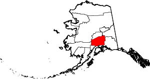 Location in the U.S. state of Alaska | |
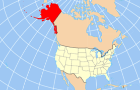 Alaska's location in the U.S. | |
| Incorporated | January 1, 1964[1][2] |
| Seat | Palmer |
| Largest city | Wasilla |
| Area | |
| • Total | 25,258 sq mi (65,418 km2) |
| • Land | 24,608 sq mi (63,734 km2) |
| • Water | 650 sq mi (1,683 km2), 2.6% |
| Population (est.) | |
| • (2015) | 101,095 |
| • Density | 3.6/sq mi (1/km²) |
| Congressional district | At-large |
| Time zone | Alaska: UTC-9/-8 |
| Website |
www |
Matanuska-Susitna Borough (often referred to as the Mat-Su Borough) is a borough located in the U.S. state of Alaska.
The borough is part of the Anchorage Metropolitan Statistical Area, along with the city and borough of Anchorage on its south.
The Mat-Su Borough is so designated because it contains the entire Matanuska and Susitna Rivers. These rivers empty into Cook Inlet which is the southern border of the Mat-Su Borough. This area is one of the few agricultural areas of Alaska.
Geography
The borough seat is Palmer,[3] and the largest city is Wasilla.
As of the 2010 census, the population was 88,995.[4]
According to the U.S. Census Bureau, the borough has a total area of 25,258 square miles (65,420 km2), of which 24,608 square miles (63,730 km2) is land and 650 square miles (1,700 km2) (2.6%) is water.[5]
Adjacent boroughs and census areas
- Denali Borough, Alaska - north
- Southeast Fairbanks Census Area, Alaska - northeast
- Valdez-Cordova Census Area, Alaska - east
- Municipality of Anchorage, Alaska - south
- Kenai Peninsula Borough, Alaska - south
- Bethel Census Area, Alaska - west
- Yukon-Koyukuk Census Area, Alaska - west
National protected areas in the borough
- Chugach National Forest (part)
- Denali National Park and Preserve (part)
- Denali Wilderness (part)
- Lake Clark National Park and Preserve (part)
- Lake Clark Wilderness (part)
Demographics
| Historical population | |||
|---|---|---|---|
| Census | Pop. | %± | |
| 1960 | 5,188 | — | |
| 1970 | 6,509 | 25.5% | |
| 1980 | 17,816 | 173.7% | |
| 1990 | 39,683 | 122.7% | |
| 2000 | 59,322 | 49.5% | |
| 2010 | 88,995 | 50.0% | |
| Est. 2015 | 101,095 | [6] | 13.6% |
| U.S. Decennial Census[7] 1790-1960[8] 1900-1990[9] 1990-2000[10] 2010-2015[4] | |||
As of the census[11] of 2000, there were 59,322 people, 20,556 households, and 15,046 families residing in the borough. The population density was 2 people per square mile (1/km²). There were 27,329 housing units at an average density of 1 per square mile (0/km²). The racial makeup of the borough was 87.55% White, 0.69% Black or African American, 5.50% Native American, 0.70% Asian, 0.12% Pacific Islander, 0.86% from other races, and 4.57% from two or more races. 2.50% of the population were Hispanic or Latino of any race.
There were 20,556 households out of which 42.30% had children under the age of 18 living with them, 58.90% were married couples living together, 9.10% had a female householder with no husband present, and 26.80% were non-families. 20.30% of all households were made up of individuals and 4.10% had someone living alone who was 65 years of age or older. The average household size was 2.84 and the average family size was 3.29.
In the borough the population was spread out with 32.20% under the age of 18, 7.40% from 18 to 24, 31.10% from 25 to 44, 23.40% from 45 to 64, and 5.90% who were 65 years of age or older. The median age was 34 years. For every 100 females there were 108.20 males. For every 100 females age 18 and over, there were 108.10 males.
Schools in the borough are administered by the Matanuska-Susitna Borough School District.
Politics and government

Matanuska-Susitna Borough was the largest (by population as well as area) of fifteen county-equivalents in America carried by Ross Perot in the 1992 presidential election;[12] apart from that Republicans have carried the borough in every election since 1968.
Vern Halter is the mayor of the Matanuska-Susitna Borough. The borough has a strong manager form of government. John Moosey is the borough manager. Long-time Manager John Duffy retired in 2010.[13]
Cities and towns
- Alexander (Creek)
- Big Lake
- Buffalo Soapstone
- Butte
- Chase
- Chickaloon
- Dinglishna Hills
- Eureka Roadhouse
- Farm Loop
- Fishhook
- Gateway
- Glacier View
- Houston
- Knik River
- Knik-Fairview
- Lake Louise
- Lakes
- Lazy Mountain
- Meadow Lakes
- Palmer
- Petersville
- Point MacKenzie
- Skwentna
- Susitna
- Susitna North
- Sutton-Alpine
- Talkeetna
- Tanaina
- Trapper Creek
- Wasilla
- Willow
See also
References
- ↑ "History". Matanuska-Susitna Borough Joint Land Use Study. 2009. Retrieved 2012-05-04.
- ↑ 1996 Alaska Municipal Officials Directory. Juneau: Alaska Municipal League/Alaska Department of Community and Regional Affairs. January 1996. p. 12.
- ↑ "Find a County". National Association of Counties. Retrieved 2011-06-07.
- 1 2 "State & County QuickFacts". United States Census Bureau. Retrieved May 17, 2014.
- ↑ "US Gazetteer files: 2010, 2000, and 1990". United States Census Bureau. 2011-02-12. Retrieved 2011-04-23.
- ↑ "County Totals Dataset: Population, Population Change and Estimated Components of Population Change: April 1, 2010 to July 1, 2015". Retrieved July 2, 2016.
- ↑ "U.S. Decennial Census". United States Census Bureau. Retrieved May 17, 2014.
- ↑ "Historical Census Browser". University of Virginia Library. Retrieved May 17, 2014.
- ↑ "Population of Counties by Decennial Census: 1900 to 1990". United States Census Bureau. Retrieved May 17, 2014.
- ↑ "Census 2000 PHC-T-4. Ranking Tables for Counties: 1990 and 2000" (PDF). United States Census Bureau. Retrieved May 17, 2014.
- ↑ "American FactFinder". United States Census Bureau. Retrieved 2011-05-14.
- ↑ Geographie Electorale
- ↑ Matanuska-Susitna Borough. Matsugov.us. Retrieved on 2013-08-02.
External links
| Wikimedia Commons has media related to Matanuska-Susitna Borough, Alaska. |
| Wikivoyage has a travel guide for Matanuska-Susitna Borough. |
- official government website
- Borough Facebook
- Borough newsroom
- Borough map, 2000 census: Alaska Department of Labor
- Borough map, 2010 census: Alaska Department of Labor
 |
Denali Borough | Southeast Fairbanks Census Area | | |
| Bethel Census Area and Yukon-Koyukuk Census Area | |
Valdez-Cordova Census Area | ||
| ||||
| | ||||
| Municipality of Anchorage and Kenai Peninsula Borough |
Municipalities and communities of Matanuska-Susitna Borough, Alaska, United States | ||
|---|---|---|
| Cities | | |
| CDPs | ||
| Unincorporated communities | ||
Juneau (capital) | ||
| Topics |
|  |
| Society |
| |
| Regions | ||
| Largest cities | ||
| Boroughs | ||
| Census Areas | ||
Coordinates: 62°24′N 149°35′W / 62.40°N 149.58°W