Sitka, Alaska
| Sitka Sheet'ká | |
|---|---|
| City and borough | |
| City and Borough of Sitka | |
|
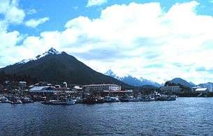
View toward Sitka from the Pacific Ocean. Sitka is the only town in Southeast Alaska that faces the Gulf of Alaska head-on. | |
 | |
| Coordinates: 57°3′5.62″N 135°20′19.11″W / 57.0515611°N 135.3386417°WCoordinates: 57°3′5.62″N 135°20′19.11″W / 57.0515611°N 135.3386417°W | |
| Country |
|
| State |
|
| Colonized | 1799, 1804 |
| Incorporated[1] |
November 5, 1913 (city) September 24, 1963 (borough) December 2, 1971 (unified municipality) |
| Government | |
| • Mayor | Mim McConnell[2] |
| • State senator | Bert Stedman (R) |
| • State rep. | Jonathan Kreiss-Tomkins (D) |
| Area | |
| • City and borough | 12,460 km2 (4,811 sq mi) |
| • Land | 7,400 km2 (2,870 sq mi) |
| • Water | 5,030 km2 (1,941 sq mi) |
| • Urban | 5 km2 (2 sq mi) |
| Elevation | 8 m (26 ft) |
| Population (2010) | |
| • City and borough | 8,881 ranked 4th |
| • Density | 1.2/km2 (3.1/sq mi) |
| • Urban | 6,982 |
| Time zone | Alaska (UTC-9) |
| • Summer (DST) | Alaska (UTC-8) |
| ZIP | 99835 |
| Area code | 907 |
| FIPS code | 02-70540 |
| GNIS feature ID | 1414736 |
| Website |
www |
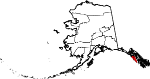
The City and Borough of Sitka (Tlingit: Sheetʼká), formerly New Arkhangelsk, or New Archangel under Russian rule (Russian: Ново-Архангельск or Новоaрхангельск, t Novoarkhangelsk), is a unified city-borough located on Baranof Island and the southern half of Chichagof Island in the Alexander Archipelago of the Pacific Ocean (part of the Alaska Panhandle), in the U.S. state of Alaska. As of the 2010 census, the population was 8,881.[3] In terms of land area, it is the largest city-borough in the U.S., with a land area of 2,870.3 square miles (7,434 square kilometres) and a total area (including water area) of 4,811.4 square miles (12,461 square kilometres). Urban Sitka, the part that is usually thought of as the "city" of Sitka, is situated on the west side of Baranof Island.
History
The current name Sitka (derived from Sheet’ká, a contraction of the Tlingit Shee At'iká)[4] means "People on the Outside of Baranof Island", whose Tlingit name is Sheet’-ká X'áat'l (here contracted to Shee).
Sitka's location was originally settled by the Tlingit people over 10,000 years ago.
Russian America
_by_Postels.jpg)
.jpg)
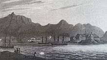
The Russians settled Old Sitka in 1799, calling it Redoubt Saint Michael (Russian: форт Архангела Михаила, t Fort Arkhangela Mikhaila). The governor of Russian America, Alexander Baranov, arrived under the auspices of the Russian-American Company, a colonial trading company chartered by Tsar Paul I. In June 1802, Tlingit warriors destroyed the original settlement, killing many of the Russians, with only a few managing to escape.[5]:37–39 Baranov was forced to levy 10,000 rubles in ransom for the safe return of the surviving settlers.[6]
Baranov returned to Sitka in August 1804, with a large force, including Yuri Lisyansky's Neva. The ship bombarded the Tlingit fort on the 20th, but was not able to cause significant damage. The Russians then launched an attack on the fort and were repelled. However, after a couple days of bombardment, the Tlingit "hung out a white flag" on the 22nd, and then deserted the fort on the 26th.[5]:44–49
Following their victory at the Battle of Sitka, the Russians established New Archangel as a permanent settlement named after Arkhangelsk, the largest city in the region where Baranov was born. The Tlingit re-established a fort on the Chatham Strait side of Peril Strait to enforce a trade embargo with the Russian establishment. In 1808, with Baranov still governor, Sitka was designated the capital of Russian America.
Bishop Innocent lived in Sitka after 1840. He was known for his interest in education, and his house, parts of which served as a schoolhouse, the Russian Bishop's House has since been restored by the National Park Service as part of the Sitka National Historical Park.
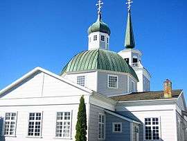
The Cathedral of Saint Michael was built in Sitka in 1848 and became the seat of the Russian Orthodox bishop of Kamchatka, the Kurile and Aleutian Islands, and Alaska. The original church burnt to the ground in 1966, but was restored to its original appearance, with the deliberate exception of its clockface, which is black in photographs taken prior to 1966, but white in subsequent photos.
Swedes, Finns and other Lutherans worked for the Russian-American Company,[7] and the Sitka Lutheran Church, built in 1840, was the first Protestant church on the Pacific coast. After the transition to American control, following the purchase of Alaska from Russia by the United States in 1867, the influence of other Protestant religions increased, and Saint-Peter's-by-the-Sea Episcopal Church was consecrated as "the Cathedral of Alaska" in 1900.[8]
Territorial Alaska
Sitka was the site of the transfer ceremony for the Alaska purchase on October 18, 1867. Russia was going through economic and political turmoil after it lost the Crimean War to Britain, France, and Turkey in 1856 and decided it wanted to sell Alaska before it got taken over by Britain. Russia offered to sell it to the United States. Secretary of State William Seward had wanted to purchase Alaska for quite some time as he saw it as an integral part of Manifest Destiny and America's reach to the Pacific Ocean.[9] While the agreement to purchase Alaska was made in April 1867, the actual purchase and transfer of power took place on October 18, 1867. The cost to purchase Alaska was $7.2 million.
Sitka served as the capital of the Alaska Territory until 1906, when the seat of government was relocated north to Juneau.
Alaska Native Brotherhood, Alaska Native Sisterhood
The Alaska Native Brotherhood was founded in Sitka in 1912 to address racism against Alaska Native people in Alaska.[10] By 1914 the organization had constructed the Alaska Native Brotherhood Hall on Katlian Street, which was named after a Tlingit war chief in the early period of Russian colonization.[11]
World War II
In 1937, the United States Navy established the first seaplane base in Alaska on Japonski Island.[12] In 1941, construction began on Fort Ray, an army garrison to protect the Naval air station.[12] Both the Army and Navy remained in Sitka until the end of WWII, when the Army-based was put into caretaker status. The Navel station in Sitka was deactivated in June 1944.[12]
Alaska Pulp Corporation
The Alaska Pulp Corporation was the first Japanese investment in the United States after WWII. In 1959 it began to produce pulp harvested from the Tongass National Forest under a 50-year contract with the US Forrest Service.[13] At its peak, the mill employed around 450 people before closing in 1993
Sitka's Filipino community established itself in Sitka before 1929. It later became institutionalized as the Filipino Community of Sitka in 1981.[14]
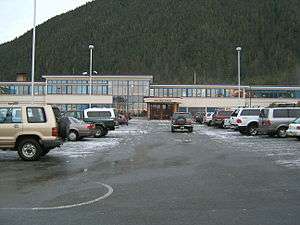
Gold mining and fish canning paved the way for the town's initial growth. Today Sitka encompasses portions of Baranof Island and the smaller Japonski Island (across the Sitka Channel from the town), which is connected to Baranof Island by the O'Connell Bridge. The John O'Connell Bridge was the first cable-stayed bridge built in the Western Hemisphere. Japonski Island is home to Sitka Rocky Gutierrez Airport (IATA: SIT; ICAO: PASI), the Sitka branch campus of the University of Alaska Southeast, Mt. Edgecumbe High School (a state-run boarding school for rural Alaskans), Southeast Alaska Regional Health Consortium's Mt. Edgecumbe Hospital, a U.S. Coast Guard Air Station Sitka, and the port and facilities for the USCGC Maple.
Geography
According to the United States Census Bureau, the borough is the largest incorporated city by area in the U.S., with a total area of 4,811 square miles (12,460.4 km2), of which 2,870 square miles (7,400 km2) is land and 1,941 square miles (5,030 km2) (40.3%) is water.
Sitka displaced Juneau, Alaska as the largest incorporated city by area in the United States upon the 2000 incorporation with 2,874 square miles (7,440 km2) of incorporated area. Juneau's incorporated area is 2,717 square miles (7,040 km2). Jacksonville, Florida, is the largest city in area in the contiguous 48 states at 758 square miles (1,960 km2).
Climate
- Sitka has an oceanic climate (Köppen Cfb) with moderate, but generally cool, temperatures and abundant precipitation.
- Average annual precipitation is 131.74 inches (3,350 mm); average seasonal snowfall is 33 inches (84 cm), falling on 233 and 19 days respectively.
- The mean annual temperature is 45.3 °F (7.4 °C), with monthly means ranging from 36.4 °F (2.4 °C) in January to 57.2 °F (14.0 °C) in August.
- Only 5.1 days per year see highs at or above 70 °F (21 °C); conversely, there are only 10 days with the high not exceeding freezing.[15]
- Extremes range from a −1 °F (−18.3 °C) low overnight on February 16–17, 1948, and a high of 88 °F (31.1 °C) July 30, 1976.[15]
- The winters are extremely mild compared to inland areas of similar and much more southerly parallels due to the intense maritime moderation. The relatively mild nights ensure that four months stay above the 50 °F (10 °C) isotherm that normally separates inland areas from being boreal in nature. Overall, the climate is like that of Fort William in Scotland.
- Due to the mild winter nights, plant hardiness is high for the latitude.
| Climate data for Sitka, Alaska (Japonski Island, 1981–2010) | |||||||||||||
|---|---|---|---|---|---|---|---|---|---|---|---|---|---|
| Month | Jan | Feb | Mar | Apr | May | Jun | Jul | Aug | Sep | Oct | Nov | Dec | Year |
| Record high °F (°C) | 60 (16) |
61 (16) |
61 (16) |
76 (24) |
82 (28) |
85 (29) |
88 (31) |
84 (29) |
77 (25) |
68 (20) |
65 (18) |
65 (18) |
88 (31) |
| Average high °F (°C) | 40.5 (4.7) |
41.3 (5.2) |
43.0 (6.1) |
48.2 (9) |
53.1 (11.7) |
57.8 (14.3) |
60.4 (15.8) |
61.9 (16.6) |
57.8 (14.3) |
50.5 (10.3) |
43.7 (6.5) |
41.4 (5.2) |
50.0 (10) |
| Daily mean °F (°C) | 36.4 (2.4) |
36.7 (2.6) |
38.0 (3.3) |
42.5 (5.8) |
47.8 (8.8) |
52.8 (11.6) |
56.2 (13.4) |
57.2 (14) |
53.0 (11.7) |
46.1 (7.8) |
39.5 (4.2) |
37.0 (2.8) |
45.3 (7.4) |
| Average low °F (°C) | 32.3 (0.2) |
32.1 (0.1) |
32.9 (0.5) |
36.8 (2.7) |
42.4 (5.8) |
47.8 (8.8) |
52.0 (11.1) |
52.5 (11.4) |
48.2 (9) |
41.6 (5.3) |
35.2 (1.8) |
33.1 (0.6) |
40.6 (4.8) |
| Record low °F (°C) | 0 (−18) |
−1 (−18) |
4 (−16) |
15 (−9) |
29 (−2) |
35 (2) |
41 (5) |
34 (1) |
31 (−1) |
20 (−7) |
2 (−17) |
1 (−17) |
−1 (−18) |
| Average precipitation inches (mm) | 8.74 (222) |
6.26 (159) |
5.83 (148.1) |
4.26 (108.2) |
4.26 (108.2) |
2.88 (73.2) |
3.99 (101.3) |
7.00 (177.8) |
11.85 (301) |
13.16 (334.3) |
9.85 (250.2) |
8.59 (218.2) |
86.66 (2,201.2) |
| Average snowfall inches (cm) | 9.1 (23.1) |
8.5 (21.6) |
5.1 (13) |
1.0 (2.5) |
0 (0) |
0 (0) |
0 (0) |
0 (0) |
0 (0) |
0.3 (0.8) |
5.0 (12.7) |
4.0 (10.2) |
33.0 (83.8) |
| Average precipitation days (≥ 0.01 in) | 22.0 | 16.8 | 18.7 | 17.2 | 17.5 | 15.5 | 18.6 | 19.4 | 22.3 | 24.4 | 21.6 | 21.0 | 235 |
| Average snowy days (≥ 0.1 in) | 4.8 | 4.0 | 3.3 | 0.8 | 0.1 | 0 | 0 | 0 | 0 | 0.4 | 3.3 | 2.7 | 19.3 |
| Source: NOAA[15] | |||||||||||||
Geology
Mount Edgecumbe, a 3,200-foot (980 m) dormant stratovolcano, is located on southern Kruzof Island. It can be seen on a clear day from Sitka.
Adjacent boroughs and census areas
- Hoonah-Angoon Census Area, Alaska – north, northeast
- Petersburg Census Area, Alaska – southeast
National protected areas
- Alaska Maritime National Wildlife Refuge (part of Gulf of Alaska unit)
- Sitka National Historical Park
- Tongass National Forest (part)
Demographics
| Historical population | |||
|---|---|---|---|
| Census | Pop. | %± | |
| 1900 | 1,399 | — | |
| 1910 | 1,035 | −26.0% | |
| 1920 | 1,175 | 13.5% | |
| 1930 | 1,056 | −10.1% | |
| 1940 | 3,987 | 277.6% | |
| 1950 | 1,985 | −50.2% | |
| 1960 | 3,237 | 63.1% | |
| 1970 | 3,370 | 4.1% | |
| 1980 | 7,803 | 131.5% | |
| 1990 | 8,588 | 10.1% | |
| 2000 | 8,835 | 2.9% | |
| 2010 | 8,881 | 0.5% | |
| Est. 2015 | 8,863 | [16] | −0.2% |
As of the 2010 census, there were 8,881 people residing in the borough. The racial makeup of the borough, based on one race alone or in combination with one or more other races, was, 64.6% White (including White Hispanic and Latino Americans), 1% Black or African American, 24.6% Native American, 8.1% Asian, 0.9% Pacific Islander, 1.8% from other races. In addition, 4.9% of the population were Hispanic and Latino Americans of any race.
There were 3,545 households out of which 29.5% had children under the age of 18 living with them, 45.5% were married couples living together, 10.7% had a female householder with no husband present, 6.1% had a male householder with no wife present, and 37.6% were non-families. The average household size was 2.43 and the average family size was 3.01.[18]
Economy
In 2010, Sitka's two largest employers were the South East Alaska Regional Health Consortium (SEARHC), employing 482 people, and the Sitka School District, employing 250 people. However, there are more people employed in the seafood industry than in any other sector. An estimated 18% of Sitka's population earns at least a portion of their income from fishing and seafood harvesting and processing. Many Sitkans hunt and gather subsistence foods such as fish, deer, berries, seaweeds and mushrooms for personal use.[19]
Within the total 2010 population of 8,881 residents, an estimated 7,161 were over 16 years of age. Of residents aged 16 and over, an estimated 4,692 were employed within the civilian labor force, 348 were unemployed (looking for work), 192 were employed in the armed forces (U.S. Coast Guard), and 1,929 were not in the labor force. The average unemployment rate between 2006 and 2010 was 6.9%. The median household income in 2010 inflation adjusted dollars was $62,024. An estimated 4.3% of all families / 7% of all residents had incomes below the poverty level "in the past twelve months"(2010).[20]
Sitka's power is generated by dams at Blue Lake and Green Lake, with supplemental power provided by burning diesel when electric demand exceeds hydro capacity. In December 2012 the Blue Lake Expansion project began, which will create 27 percent more electricity for the residents of Sitka. The project is expected to be finished by December 2014.[21]
In 2010 a Texas company S2C Global Systems announced that it was moving forward with a plan to ship 2.9 billion US gallons (11,000,000 m3) to 9 billion US gallons (34,000,000 m3) of fresh lake water a year from Sitka (Blue Lake) to the west coast of India.[22] The deal would represent the world's first regular, bulk exports of water via tanker.[23] The water will be redistributed to places in India, southeast Asia and the Middle East. Sitka could earn up to $90 million a year in revenue.[23] As of January 2013, this project seems to have ended in failure.[24][25]
Port
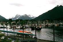
Sitka is the 6th largest port by value of seafood harvest in the United States.[19] International trade is relatively minor, with total exports and imports valued at $474,000 and $146,000, respectively, in 2005 by the American Association of Port Authorities.[26] The port has the largest harbor system in Alaska with 1,347 permanent slips.
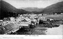
During Russian rule, Sitka was a busy seaport on the west coast of North America,[27] mentioned a number of times by Dana in his popular account of an 1834 sailing voyage Two Years Before the Mast. After transfer of Alaska to U.S. rule, the Pacific Coast Steamship Company began tourist cruises to Sitka in 1884. By 1890, Sitka was receiving 5,000 tourist passengers a year.[28]
Arts and Culture
There are 22 buildings and sites in Sitka that appear in the National Register of Historic Places.[29]
Annual Events
Alaska Day, October 18th
On October 18, Alaska celebrates Alaska Day to commemorate the Alaska purchase. The City of Sitka holds an annual Alaska Day Festival. This week-long event includes a reenactment ceremony of the signing of the Alaska purchase, as well as interpretive programs at museums and parks, special exhibits, aircraft displays and film showings, receptions, historic sites and buildings tours, food, prose writing contest essays, Native and other dancing, and entertainment and more. The first recorded Alaska Day Festival was held in 1949.[30]
_-_NARA_-_297241.jpg)
Government
City and Borough of Sitka
The City and Borough of Sitka is a Unified Home Rule [31][32] city. The home rule charter of the City and Borough of Sitka was adopted on 2 December 1971[33] for the region of the Greater Sitka Borough, which included Mt. Edgcome on Japonski Island and Port Alexander and Baranof Warm Springs on Baranof Island. The city was incorporated on 24 September 1963.[34] On October 23, 1973, the city of Port Alexander was detached from the borough.[35]
Education
Colleges and universities
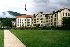
Sitka hosts one active post-secondary institution, the University of Alaska Southeast-Sitka Campus, located on Japonski Island in an old World War II hangar. Sheldon Jackson College, a small Presbyterian-affiliated private college suspended operations in June, 2007, after several years of financial stress.
Schools
The Sitka School District runs several schools in Sitka, including Sitka High School and Pacific High School, as well as the town's only middle school, Blatchley Middle School. They also run a home school assistance program through Terry's Learning Center.
Mt. Edgecumbe High School, a State of Alaska-run boarding high school for rural, primarily Native, students, is located on Japonski Island adjacent to University of Alaska Southeast.
Two private schools are available in Sitka: Sitka Adventist School and The SEER School.
Alaska State Trooper Academy
The Alaska State Trooper Academy — the academy for all Alaska State Troopers — is located in Sitka.
Libraries
Kettleson Memorial Library is the public library for Sitka. It receives about 100,000 guests annually and houses a collection of 75,000 books, audiobooks, music recordings, reference resources, videos (DVD and VHS) as well as an assortment of Alaskan and national periodicals. Its annual circulation is 133,000. The library is well known by visitors for its view. The large windows in front of the reading area look south across Eastern Channel towards the Pyramids.
Until its closing, Sitka was also home to Stratton Library, the academic library of Sheldon Jackson College.
Media
Sitka is served by the Daily Sitka Sentinel, one of the remaining few independently-owned daily newspapers in the state. Sitka also receives circulation of the Capital City Weekly — a weekly regional newspaper based out of Juneau.
Alaska's first newspaper following the Alaska purchase, the Sitka Times, was published by Barney O. Ragan on September 19, 1868. Only four issues were published that year, as Ragan cited a lack of resources available at the time. The paper resumed publishing the following year as the Alaska Times. In 1870, it moved to Seattle, where the year following it was renamed the Seattle Times (not to be confused with the modern-day newspaper of the same name).[36]
Radio
The public radio station KCAW (Raven Radio) and commercial radio stations KIFW and KSBZ fill the airwaves.
Television
KTNL-TV (CBS) broadcasts out of Sitka on Channel 13 (Cable 6) serving Southeast Alaska. Additionally, KSCT-LP (NBC) Channel 5, KTOO (PBS) Channel 10,[37] and KJUD (cable-only ABC/CW) serve the region.
Infrastructure
Transportation
Sitka is only accessible by boat or plane as it is a series of islands in the Pacific Ocean. Vehicles are usually brought to Sitka via the Alaska Marine Highway ferry system. However, a vehicle is not an absolute necessity in Sitka, Alaska, as there are only 14 miles (23 kilometres) of road from one end of the island to another. Most everything is within walking distance from the downtown area which is where a majority of employers are situated. There is also public transportation available.
By air, Sitka Rocky Gutierrez Airport offers scheduled passenger jet service operated year-round by Alaska Airlines and seasonally by Delta Connection as well as charter and bush air service provided by Harris Aircraft Services.
Delays in fall and winter due to Sitka's weather are frequent. The airport is located on Japonski Island, which is connected to Baranof Island by the O'Connell Bridge. The O'Connell Bridge, completed in 1972, was the first vehicular cable-stayed bridge in the United States. The Sitka Seaplane Base is seaplane landing area situated in the Sitka Channel, adjacent to the airport.
Ferry travel back and forth to Juneau, Ketchikan and other towns in Southeast Alaska is provided through the Alaska Marine Highway System. The ferry terminal is located 7 miles (11 km) north of downtown and a ferry ticket costs about $49 per person each way to Juneau (as of July 2013). Vehicles, pets and bicycles can also be taken on the ferry for an additional charge.
Sitka's location on the outer coast of the Alaska Panhandle is removed from routes run through Chatham Strait. This, in addition to the tides of Peril Straits that allow mainline vessels through only at slack tide combine to result in no designated service by a vessel and minimal service overall. However, the AMHS is often the mode of transportation of choice when the schedule proves convenient because of its much cheaper cost.
Alaska Marine Lines, a barge and freight company, also has the ability to move cars to other communities connected to the mainland by road systems.
A three-way partnership of non-profits Center for Community, Sitka Tribe of Alaska, and Southeast Senior Services offers public bus transit, funded by the Federal Transit Administration and the Alaska Department of Transportation. All buses are fully accessible, with services from 6:30 a.m. to 7:30 p.m., Monday through Friday.
In 2008, the League of American Bicyclists awarded Sitka the bronze level in bicycle friendliness making Sitka the first bicycle-friendly community in Alaska. In 2013, the Walk Friendly Communities[38] program awarded Sitka with a bronze award, making Sitka the first Alaska community with a Walk Friendly Communities designation. Sitka is the only Alaska community to have both a Bicycle Friendly Community and a Walk Friendly Communities designation.
Health care
There are two hospitals located in Sitka. The first, Sitka Community Hospital, is located in the downtown area and offers a full range of health care services including general medical care, surgery, 24/7 emergency room, laboratory, radiology, rehabilitative services, outpatient clinic, home health, infusion therapy, visiting specialists and long term care. The second, Mt. Edgecumbe Hospital, is located across Sitka Harbor on Japonski Island about one half mile from Sitka Rocky Gutierrez Airport. The facility is part of the Southeast Alaska Regional Health Consortium, or SEARHC, a non-profit tribal health consortium of 18 Native communities. The hospital serves as a regional referral center for people throughout Southeast Alaska, and also provides primary outpatient care. Numerous specialty clinics are offered at the hospital that are not available in the smaller communities such as: neurology, orthopedic, dermatology, ophthalmology and denture clinic.
Notable people

- Marko Dapcevich, former mayor of Sitka
- Dale DeArmond, printmaker and book illustrator
- Annie Furuhjelm, Finnish journalist and legislator
- Sheldon Jackson, Presbyterian missionary in Alaska in late 19th century
- Scott McAdams, 2010 Democratic U.S. Senate Candidate
- Richard Nelson, cultural anthropologist, writer, and activist
- John Straley, award-winning author
Twin towns – Sister cities
Sitka has the following sister city:[39]
Attractions
Sitka's attractions include:
- Alaska Raptor Center
- Baranof Castle Hill
- Sheet'ká Kwáan Naa Kahídi
- Russian Bishop's House
- Saint Lazaria National Wildlife Refuge
- St. Michael's Cathedral
- Sheldon Jackson Museum
- Sitka Fine Arts Camp
- Sitka Historical Museum
- Sitka Jazz Festival
- Sitka Lutheran Church
- Sitka National Historical Park
- Sitka Pioneer Home
- Sitka Summer Music Festival
- Swan Lake
- Tongass National Forest
The flora and fauna of Sitka and its surrounding area are popular. Day cruises and guided day trips (hiking) are large enterprises in Sitka. Floatplane "flightseeing" excursions are a way to view the area's sights from above.
Outdoor opportunities
Sitka's position between the Pacific Ocean and the most mountainous island in the Alexander Archipelago creates a variety of outdoor opportunities:

- The Baranof Cross-Island Trail, which leads to the small community of Baranof Warm Springs on the eastern side of the island, is a popular summer backpacking trip. Only serious and experienced backpackers, or those with an experienced guide, should undertake such a trip due to volatile weather conditions in the mountains and the required crossings of icefields with crevasses.
- The dormant volcano Mount Edgecumbe is also a popular mountain to summit and features a seven-mile (11 km) trail up to the top. Guided day-trips are available, but the trip does not require much knowledge to undertake.
- The officially unnamed, but informally named Peak 5390 (the name is derived from its height in feet) is the highest point on Baranof Island and a demanding climb. Few people undertake this peak; those interested should consult with one who has summited previously.
- Kayaking is a popular activity and small guided day excursions are offered locally.
- There are a number of maintained trails in the Sitka area, many of which are accessible from Sitka's road system.
In popular culture
- Louis L'Amour penned Sitka, his fictional account of the events surrounding the United States' purchase of the Alaska Territory from the Russians for $7.2 million in 1867.
- Novelist James Michener resided at Sitka's Sheldon Jackson College while doing research for his epic work, Alaska.
- The 1952 film The World in His Arms has Russian Sitka as one of its settings.
- Sitka is the opening setting in Ivan Doig's 1982 historical fiction The Sea Runners.
- Sitka is mentioned in Chapter 53 of James Clavell's 1993 historical fiction about Japan Gai-Jin.
- Mystery author John Straley described Sitka as "...an island town where people feel crowded by the land and spread out on the sea."
- Part of the action in the novel César Cascabel by Jules Verne takes place in Sitka in May–June, 1867 during the transfer of ownership to the United States.
- A fictionalized Sitka, with a population in the millions and the host of a fictional 1977 World's Fair, is the setting of the alternate history detective story The Yiddish Policemen's Union, by Michael Chabon.
- Sitka is a character in the 2003 Disney animated feature Brother Bear.
- Sitka is a setting used in the 2009 feature The Proposal, although the scenes were filmed in Rockport, Massachusetts.
- Sitka was featured in a 2012 episode of the Travel Channel's popular series Bizarre Foods,[40] starring Andrew Zimmern. In this episode Zimmern ate herring eggs, stink heads, and sea cucumbers.
- Sitka was named one of the Top 20 Small Towns to Visit in 2013[41] by Smithsonian magazine.
- The Long Dark takes place in the area of the Sitka Islands
See also
- List of United States cities by area
- Maritime Fur Trade
- Russian Alaska
- Sitka Tribe of Alaska
- USS Sitka
References
- ↑ From November 1867 to February 1873, the earliest American settlers in Sitka established and conducted affairs under a "provisional city government", as Alaskan communities were prohibited from legally incorporating until the U.S. Congress passed legislation allowing them to do so in 1900. Mayors of Sitka under this government included William Sumner Dodge and John Henry Kinkead. See Atwood, Evangeline; DeArmond, Robert N. (1977). Who's Who in Alaskan Politics. Portland, Oregon: Binford & Mort for the Alaska Historical Commission. p. 24.; Wheeler, Keith (1977). "Learning to cope with 'Seward's Icebox'". The Alaskans. Alexandria, Virginia: Time–Life Books. pp. 57–64. ISBN 0-8094-1506-2.
- ↑ 2015 Alaska Municipal Officials Directory. Juneau: Alaska Municipal League. 2015. p. 17.
- ↑ "State & County QuickFacts". United States Census Bureau. Retrieved May 18, 2014.
- ↑ Joseph, Charlie; Brady, I.; Makinen, E.; David, R.; Davis, V.; Johnson, A.; Lord, N. (2001). "Sheet'kwaan Aani Aya". Sitka Tribe of Alaska. Retrieved 27 October 2009.
- 1 2 Khlebnikov, K.T., 1973, Baranov, Chief Manager of the Russian Colonies in America, Kingston: The Limestone Press, ISBN 0919642500
- ↑ Chevigny, Hector (1942). Lord of Alaska: Baranov and the Russian adventure. Cornell University: Viking Press. p. 320.
- ↑ Sitka Lutheran Church.
- ↑ "NRHP nomination for St. Peter's Church" (PDF). National Park Service. Retrieved 2014-10-24.
- ↑ "Meeting of Frontiers: Alaska — The Alaska Purchase".
- ↑ "ANB celebrates 100th at ANB/ANS Grand Camp in Sitka" (Press release). Raven Radio. 29 September 2012. Retrieved 7 January 2013.
- ↑ Historic Sitka Harbor and Waterfront Self-Guided Tour:Points of Interest on Sitka's Historic Waterfront (Map). Sitka Maritime Heritage Society.
- 1 2 3 Yarborough, Michael R. (April 10,200), Statement of Significance for the Fort Ray Historic District (Charcoal and Alice Islands) and the Mermaid Cove Mausoleum) (PDF), Alaska Department of Transportation and Public Facilities, retrieved October 24, 2016 Check date values in:
|date=(help) - ↑ "The Evolution of a Marine Industrial Park". www.sitka.net. Retrieved October 24, 2016.
- ↑ Klaney, Carol Kelty (1995). Gunalcheesh!. Haines, Alaska: Ptarmigan Press. pp. 77–78.
- 1 2 3 "NOAA Online Weather Data". National Oceanic and Atmospheric Administration. Retrieved February 16, 2013.
- ↑ "Annual Estimates of the Resident Population for Incorporated Places: April 1, 2010 to July 1, 2015". Retrieved July 2, 2016.
- ↑ "Census of Population and Housing". Census.gov. Retrieved June 4, 2015.
- ↑ "American FactFinder: Results". United States Census Bureau.
- 1 2 "Sitka, Alaska: 2010–2011 Community Profile". Sitka Economic Development Association: 3. External link in
|publisher=(help) - ↑ "American Community Survey, 2006–2010 5-Year Estimates". U.S. Census Bureau.
- ↑ "Blue Lake Expansion Project". Blue Lake Expansion Project.
- ↑ S2sclobal.com announces India world water hub, July 7, 2010.
- 1 2 "Alaska City Set to Ship Water to India, U.S. Company Announces", Circle of Blue, July 11, 2010
- ↑ Walton, Brett (December 10, 2010). "Bulk Water Shipping Company Misses Deadline to Export From Alaska". Circle of Blue. Retrieved January 5, 2013.
- ↑ Walton, Brett (February 2, 2011). "Alaska Bulk Water Company Receives Export Contract Extension, Wants to Split with Partner". Circle of Blue. Retrieved January 5, 2013.
- ↑ Table of 2005 U.S. Port Rankings by Foreign Commerce Cargo Value: American Association of Port Authorities
- ↑ Bunten, Alexis Celeste (2008). "Sharing Culture or Selling Out?: Developing the commodified persona in the heritage industry". American Ethnologist. American Anthropological Association. 35 (3): 382. doi:10.1111/j.1548-1425.2008.00041.x. ISSN 0094-0496.
- ↑ Ashley, McClelland (31 March 2012). The Art of Innovation: The Effects of Trade and Tourism on Tlingit Dagger Production in the Nineteenth Century (Speech). Wooshteen Kanaxtulaneegí Haa At Wuskóowu / Sharing Our Knowledge, A conference of Tlingit Tribes and Clans: Haa eetí ḵáa yís / For Those Who Come After Us. Sitka, Alaska. Retrieved 31 March 2012.
- ↑ "National Register of Historic Places, Sitka, Alaska".
- ↑ "Alaska Day Festival, Sitka, Alaska".
- ↑ "Alaska Taxable 2011: Municipal Taxation – Rates and Policies" (PDF). Division of Community and Regional Affairs, Alaska Department of Commerce, Community and Economic Development. January 2012. Retrieved January 23, 2013.
- ↑ "City-Borough Sitka" (PDF). Alaska Department of Commerce, Community and Economic Development. Retrieved July 16, 2008.
- ↑ Home Rule Charter of the City and Borough of Sitka
- ↑ Community/Borough Map: State of Alaska Department of Community and Economic Development
- ↑ "Certificate of Organization of the Unified Home Rule Municipality of the City an Borough of Sitka" (PDF). Alaska Department of Commerce, Community and Economic Development, Division of Community and Regional Affairs (DCRA). 1990-06-18. Retrieved 2012-05-04.
- ↑ Guide to Alaska Newspapers on Microfilm (PDF). Juneau: Alaska State Library. 1998. pp. 324, 332.
- ↑ Archived July 27, 2011, at the Wayback Machine.
- ↑ "walkfriendly.org".
- ↑ Alaska sister cities index Archived February 5, 2012, at the Wayback Machine.
- ↑ "Diving for Dinner in Alaska". Travel Channel.
- ↑ "History, Travel, Arts, Science, People, Places". Smithsonian.
Further reading
Looking past downtown Sitka, up Indian River valley. Probably taken from Castle Hill.
- Andrews, C.L. (1944). The Story of Alaska. Caldwell, Ohio: The Caxton Printers, Ltd.
- Fedorova, Svetlana G., trans. & ed. by Richard A. Pierce and Alton S. Donnelly (1973). The Russian Population in Alaska and California: Late 18th century – 1867. Kingston, Ontario: Limestone Press. ISBN 0-919642-53-5.
- Hope, Herb (2000). "The Kiks.ádi Survival March 1804". In Andrew Hope III and Thomas F. Thornton. Will the Time Ever Come? A Tlingit Source Book. Fairbanks, Alaska: Alaska Native Knowledge Network. pp. 48–79.
- Naske, Claus-M & Herman E. Slotnick (2003). Alaska: A History of the 49th State. Norman, Oklahoma: University of Oklahoma Press. ISBN 0-8061-2099-1.
- Nordlander, David J. (1994). For God & Tsar: A Brief History of Russian America 1741–1867. Anchorage: Alaska Natural History Association. ISBN 0-930931-15-7.
- Vaillant, John (2006). The Golden Spruce: A True Story of Myth, Madness and Greed. Vintage Canada. ISBN 978-0-676-97646-5.
- Wharton, David (1991). They Don't Speak Russian in Sitka: A New Look at the History of Southern Alaska. Menlo Park, California: Markgraf Publications Group. ISBN 0-944109-08-X.
- Wilber, Glenn (1993). The Sitka Story: Crown Jewel of Baranof Island. Sitka: "Land of Destiny"—Alaska Publications.
- Tlingit Geographical Place Names for the Sheet'ká Kwáan — Sitka Tribe of Alaska, an interactive map of Sitka Area native place names.
External links
| Wikimedia Commons has media related to Sitka, Alaska. |
| Wikivoyage has a travel guide for Sitka. |
- City & Borough of Sitka website
- Historic images
-
 "Sitka". Encyclopædia Britannica (11th ed.). 1911.
 - "Sitka". Collier's New Encyclopedia. 1921.
- "Sitka". The New Student's Reference Work. 1914.
- "Sitka". New International Encyclopedia. 1905.
 |
Hoonah-Angoon Census Area | Hoonah-Angoon Census Area | | |
| Gulf of Alaska | |
|||
| ||||
| | ||||
| Petersburg Census Area |
Municipalities and communities of the City and Borough of Sitka, Alaska, United States | ||
|---|---|---|
| Unincorporated communities | | |
Juneau (capital) | ||
| Topics |
|  |
| Society |
| |
| Regions | ||
| Largest cities | ||
| Boroughs | ||
| Census Areas | ||