Hurricane Hermine
| Category 1 hurricane (SSHWS/NWS) | |
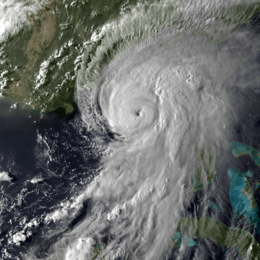 Hurricane Hermine approaching Florida at peak strength on September 1 | |
| Formed | August 28, 2016 |
|---|---|
| Dissipated | September 6, 2016 |
| (Remnant low after September 3) | |
| Highest winds |
1-minute sustained: 80 mph (130 km/h) |
| Lowest pressure | 982 mbar (hPa); 29 inHg |
| Fatalities | 4 direct, 1 indirect |
| Damage | $800 million (2016 USD) |
| Areas affected | Dominican Republic, Cuba, The Bahamas, East coast of the United States |
| Part of the 2016 Atlantic hurricane season | |
Hurricane Hermine was the first hurricane to make landfall in Florida since Hurricane Wilma in 2005, and the first to develop in the Gulf of Mexico since Hurricane Ingrid in 2013. The ninth tropical depression, eighth named storm, and fourth hurricane of the 2016 Atlantic hurricane season, Hermine developed from a long-tracked tropical wave that had produced torrential rainfall in parts of the Caribbean. After being designated on August 29, Hermine shifted northeastwards due to a trough over Georgia and steadily intensified into a Category 1 hurricane just before making landfall in the Florida Panhandle during September 2. Fast weakening ensued as the storm weakened and transitioned into a post-tropical cyclone before leaving the coast near the Outer Banks. The remnants of Hermine continued to bring heavy rain and rip-currents to the East Coast of the United States, before the NHC discontinued advisories on the system, while it was situated east of the Delmarva Peninsula.
Meteorological history
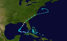
On August 18, the National Hurricane Center (NHC) first noted a tropical wave as a potential area for development, associated with an area of disorganized convection about 300 mi (480 km) southwest of Cabo Verde. Environmental conditions were expected to be favorable for continued organization.[1] Dry and stable air was an initial inhibiting factor in development,[2] although the convection and circulation had become better defined by August 21.[3] By August 23, the system had developed an elongated and poorly-defined circulation, as indicated by the Hurricane Hunters.[4] On the next day, the low pressure area crossed Guadeloupe into the Caribbean Sea while producing gale-force winds.[5][6] By this point, the NHC noted that the system could develop into a tropical depression at any time, as the system was only lacking a well-defined circulation.[7]
Marginal wind shear disrupted the system's organization, and it passed north of Puerto Rico without further development,[8] with winds dropping below gale-force on August 25.[9] The low pressure area crossed the southern Bahamas with scattered convection,[10] becoming more defined on August 27 while moving near the northern Cuban coast.[11] Wind shear prevented quicker development,[12] although conditions became more favorable closer to the Gulf of Mexico. On August 28, the convection increased and became more organized.[13] Later that day, the Hurricane Hunters observed a well-defined circulation. Based on the observations and the convective organization, the NHC initiated advisories on Tropical Depression Nine at 21:00 UTC on August 28 about halfway between the Florida Keys and the north coast of Cuba.[14]
Deep convection increased further as the depression moved more into the Gulf of Mexico,[15] steered by a ridge over southern Florida,[16] although it remained ragged and displaced from the circulation.[17] Dry air to the system's west negated the otherwise favorable warm waters.[16] The depression failed to organize more on August 30 as the low- and mid-level circulations remained misaligned.[18] A large plume of convection developed over the system on August 31 as outflow improved and wind shear decreased.[19] Later that day, reports from the Hurricane Hunters indicated that the depression intensified into Tropical Storm Hermine about 395 mi (640 km) southwest of Apalachicola, Florida.[20] Late on August 31, Hermine began accelerating to the northeast, influenced by a developing mid-level trough over the southeastern United States.[21] Lessening shear and water temperatures around 86 °F (30 °C) allowed the storm to intensify.[22] Although outflow was restricted to the northwest, curved rainbands increased over the eastern half of the system,[23] increasing the extent of tropical storm-force winds.[24] At 18:55 UTC on September 1, the NHC upgraded Hermine to hurricane status after the Hurricane Hunters observed winds of 75 mph (120 km/h).[25]
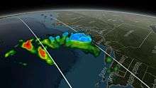
The hurricane strengthened slightly further to a peak intensity of 80 mph (130 km/h) by 00:00 UTC on September 2.[26] At around 05:30 UTC (1:30 a.m. EDT) that day, Hermine made landfall just east of St. Marks, Florida at peak intensity, with a minimum pressure of 982 mbar (hPa; 29.00 inHg).[27] Hermine became the first hurricane to make landfall in Florida since Wilma on October 24, 2005.[28] Within four hours of landfall, the winds dropped below hurricane force as the appearance on radar imagery degraded.[29] The convection diminished while Hermine crossed into Georgia, with the strongest winds near the Atlantic coast.[30] The center elongated as it continued quickly northeastward ahead of the trough.[31] With the convection far ahead of the circulation, Hermine transitioned into a post-tropical cyclone on September 3 as it emerged into the Atlantic Ocean from the Outer Banks of North Carolina.[32] Dry air wrapped into the eastward-moving center,[33] while convection pulsed north of the former hurricane, possibly due to the warmer waters of the Gulf Stream.[34] By September 5, the system devolved into several rotating circulations as the overall system slowed and turned to the northwest, steered by a ridge to the north.[35] The convection began waning on the next day,[36] as the storm turned due westward.[37] At 18:00 UTC on September 6, the NHC ceased issuing advisories on the post-tropical cyclone as Hermine continued to weaken, due to cooler waters and convective instability.[38]
Preparations

On August 30, the NHC began issuing tropical cyclone warnings and watches for the Florida gulf coast.[39] By the time Hermine reached hurricane status, a hurricane warning was in place from the mouth of the Suwannee River to Mexico Beach. A tropical storm warning extended southward to Englewood, which included the Tampa Bay Area, and westward to the Walton–Bay county line. A hurricane watch was also in effect from the mouths of the Suwannee and Anclote rivers.[26] On August 31, a tropical storm watch was added for the Atlantic coast between Marineland, Florida, to the Altamaha Sound in Georgia.[40] As Hermine approached and moved up the coast, tropical storm warnings were in place as far south as Marineland,[26] and as far northeast as Sagamore Beach, Massachusetts, including portions of the Tidal Potomac River, the Chesapeake and Delaware bays, Long Island Sound, New York City, Block Island, Martha's Vineyard, Nantucket, and Cape Cod.[41][42] All tropical storm warnings were dropped when the NHC discontinued advisories at 18:00 UTC on September 6.[38]
Florida Governor Rick Scott declared a state of emergency for 51 counties.[43] In response to the then-developing storm, early voting for the primary election on August 30 was extended by one day in Bradford, Broward, Charlotte, Duval, Hillsborough, Miami-Dade, Orange, Osceola, Palm Beach. and Pinellas counties.[44] In six counties, school was canceled on September 1 and 2, while twenty-nine other counties had no school on September 2.[43][45] Mandatory evacuations were ordered for portions of Dixie, Franklin, Taylor, and Wakulla counties.[43]
States of emergencies were declared in Georgia,[28] North Carolina, Virginia, Maryland, and New Jersey due to the storm.[46] Hermine affected the east coast of the United States during the busy Labor Day weekend, causing many beaches to be closed in Delaware, New Jersey, and New York.[46] Amtrak canceled or altered train lines due to the threat from the storm.[28] In Savannah, Georgia, Bacon Fest was cancelled, and a beer fest was moved indoors.[47] In Charleston, South Carolina, the city government provided 3,000 sandbags to residents, preparing less than a year after damaging floods hit the state. Outer Banks ferry service was cancelled[48] and bridges in Dare County, North Carolina, were closed due to the high winds. Officials deployed or readied swift water teams, helicopters, and the North Carolina National Guard in the eastern portion of the state. The Virginia National Guard utilized 270 members to help prepare for the storm's potential flooding and power outages.[48] A Bruce Springsteen concert in Virginia Beach, Virginia, was postponed two days,[46] and several performances for the town's American Music Festival were cancelled or moved indoors.[49]
Impact
Dominican Republic and Cuba
In the Dominican Republic, some areas received nearly 4 in (100 mm) of rain on August 25 alone from Hermine's precursor. In 19 provinces, residents and authorities were on alert due to rapidly rising rivers and expectations of flooding.[50] Throughout the country, the storm damaged more than 200 homes and displaced over 1,000 people.[51]
While in its developmental stages, the precursor low dropped 3 to 5 in (76 to 127 mm) of rainfall across northern Cuba.[11] Candelaria in western Cuba recorded 12.24 in (310.8 mm). The rains alleviated drought conditions and helped replenish reservoirs, while also causing landslides.[52] The Zaza Reservoir – the largest in Cuba – increased its total water volume by 495,000,000 cubic feet (14,000,000 m3), bringing the levels to 30% capacity. In Batabanó on Cuba's southern coast, the southerly winds and 8.5 in (215 mm) of rainfall caused moderate flooding.[53] Near Havana, the electric company shut off power to prevent accidents, while damage occurred to gas lines.[52]
United States
Total economic losses across the United States reached US$800 million.[54][55] Insured losses to property in Florida reached US$80 million with 14,890 claims.[56]
Florida
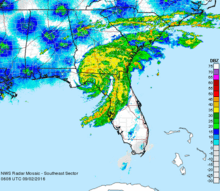
Ahead of the hurricane's landfall, a station south of Apalachicola reported wind gusts of 79 mph (127 km/h) at an elevation of 115 ft (35 m).[57] At sea level, sustained winds reached 52 mph (84 km/h) at Keaton Beach, with gusts 67 mph (108 km/h).[58] While moving ashore, Hermine produced a 5.8 ft (1.8 m) storm surge at Cedar Key.[59] Heavy rainfall occurred across western Florida, reaching 22.36 in (568 mm) over 72 hours at the Lake Tarpon Canal in Pinellas County.[60] The outer rainbands of Hermine spawned an EF0 tornado just southwest of Windermere with a width of 450 ft (140 m) and 80 to 85 mph (129 to 137 km/h) winds. On the ground for 1.2 mi (1.9 km), the twister damaged about 100 trees, along with several fences and windows.[61]
High winds from the hurricane knocked down many trees in northwestern Florida, some of which fell onto power lines and roofs. The resulting power outages affected about 325,000 people,[28] affecting 1% of all homes and businesses in the state.[48] In Leon County, where the state capital Tallahassee is, 57% of homes lost power,[48] including approximately 80% of the city proper, as well as Florida State University. Strong winds in the Tallahassee area caused trees to fall onto several houses, injuring a number of people.[28] Hermine was the first hurricane to affect the city since Hurricane Kate in 1985.[48] Losses across Leon County reached US$10.3 million.[62] In Marion County, a homeless man camping near Ocala was killed when a tree fell on his tent.[63] Falling trees in Wakulla County damaged at least seven homes and Wakulla's Gulf Specimen Marine Laboratory suffered extensive damage, especially to their educational Living Dock.[28][64] In Hernando County, the storm destroyed two houses and severely damaged 18 more, with 179 sustaining minor damage; the county damage toll was estimated at US$7.8 million.[65] Coastal areas of Citrus County suffered from significant flooding; 2,694 structures sustained damage, of which 531 suffered major damage. Total losses in the county reached US$102 million.[66]
Heavy rainfall in the Tampa Bay Area flooded streets, causing cars to stall, and forced people to evacuate their homes.[59] In Pasco County, property damage totaled US$111 million,[67] making Hermine one of the costliest storms on record in the county. Of the 2,672 households affected, 7 were destroyed, 305 sustained major damage, and 1,564 sustained minor damage.[68][69] Damage incurred by roads was estimated at US$30–50 million.[70] Eighteen people required rescue from high-water vehicles in Pasco County, transported to nearby shelters,[28] and another 12 people were evacuated in Taylor County.[71] At Dekle Beach in the latter county, the storm damaged several buildings and wrecked a 300 ft (91 m) fishing pier.[28] Power outages in the Tampa Bay area affected the local wastewater treatment plant, causing 938,000 US gallons (3,550,000 L) of partially treated sewage to flow into Hillsborough Bay.[72] In Cedar Key, storm damage was estimated at over $10 million USD.[73]
Elsewhere

Hermine weakened while crossing from Florida into Georgia, but still produced sustained winds of 45 miles per hour (72 km/h) at Savannah, with gusts to 58 miles per hour (93 km/h).[74] Farther northeast, Folly Island, South Carolina, reported sustained winds of 44 miles per hour (71 km/h) with gusts to 59 miles per hour (95 km/h),[75] and the pier in Duck, North Carolina, reported sustained winds of 58 miles per hour (93 km/h) with gusts to 73 miles per hour (117 km/h).[76] Heavy rainfall occurred through the Carolinas, reaching 10.72 in (272 mm) in Murrells Inlet, South Carolina.[77] At Norfolk International Airport, wind gusts reached 43 miles per hour (69 km/h).[78]
In Georgia, South Carolina, North Carolina, and Virginia, Hermine's passage left around 274,000 people without power.[46][48][79][80] In Georgia, Hermine's winds knocked down trees onto cars and homes, resulting in several injuries in the subsequent cleanup process, although there was no major damage.[48] A pecan farm near Ray City, GA suffered roughly US$4 million in damage as winds of 40 to 55 mph (64 to 89 km/h) felled about 1,000 trees and ruined 1 million pounds of nuts.[81] The storm spawned two EF1 tornadoes in the state. The first, with a 4.83 mi (7.77 km) path, knocked down or broke thousands of trees in Liberty County, some of which fell onto homes. The other struck Skidaway Island and downed hundreds of trees, causing damage to 20 roofs.[82] On St. Simons Island, the storm sank up to five boats at the Morning Star Marina.[83] The storm flooded roads and downed trees in South Carolina, mostly in Beaufort, Bluffton, and Hilton Head Island, causing little major damage.[48] A house in Sea Pines Plantation in Hilton Head was damaged by a fallen tree landing on the roof, just over two weeks after a tree had fallen in the same manner upon the same house. In Cottageville, a man was killed after being hit by a car while he was removing a fallen tree from the highway.[84] Hermine spawned a small tornado over North Carolina's Outer Banks, knocking over two trailers and injuring four people.[85] High winds knocked over an 18-wheeler tractor-trailer crossing the Alligator River bridge on U.S. Route 64, killing the driver.[46][47] Flooding covered portions of North Carolina Highway 12, the main roadway through the Outer Banks.[48] Damage across Dare County, North Carolina, reached US$5.4 million; most of the damage was concentrated on Hatteras Island with flooding in Frisco and Hatteras.[86]
On eastern Long Island, two fishermen drowned after being swept into the ocean near the Wading River due to rough surf.[87] Their bodies were later recovered in Shoreham.[88] Nantucket offshore Massachusetts recorded sustained winds of 39 miles per hour (63 km/h) on September 5, with gusts to 52 miles per hour (84 km/h).[89] Royal Caribbean's Anthem of the Seas encountered 40 ft (12 m) seas and 112 mph (180 km/h) winds on its trek from New Jersey to Bermuda, leaving several passengers seasick.[90]
Aftermath
After Hermine exited the state, Florida governor Rick Scott took an aerial tour of the damage in Cedar Key and Steinhatchee, pledging that affected businesses would receive assistance from the state government.[48] In Lee County, crews were deployed to collect plant debris.[91] Due to storm damage, officials in Hernando County provided curbside debris removal, and two parks were closed.[92] Nearby in Franklin County, the St. George Island Bridge was reopened just 15 hours after its closure to allow access to cleanup crews.[93]
See also
- List of Florida hurricanes (2000–present)
- Hurricane Earl (1998) – struck the Florida panhandle as a Category 2 hurricane
- Hurricane Gordon (2000) – moved ashore near Cedar Key, Florida, and proceeded up the east coast
- Hurricane Sandy – made landfall on New Jersey as an extratropical storm, causing widespread flood and tree damage
References
- ↑ Stacy Stewart (August 18, 2016). Tropical Weather Outlook (TXT) (Report). National Hurricane Center. Retrieved August 28, 2016.
- ↑ Jack Beven (August 19, 2016). Tropical Weather Outlook (TXT) (Report). National Hurricane Center. Retrieved August 28, 2016.
- ↑ Stacy Stewart (August 21, 2016). Tropical Weather Outlook (TXT) (Report). National Hurricane Center. Retrieved August 28, 2016.
- ↑ Todd Kimberlain (August 23, 2016). Tropical Weather Outlook (TXT) (Report). National Hurricane Center. Retrieved August 28, 2016.
- ↑ Todd Kimberlain (August 24, 2016). Tropical Weather Outlook (TXT) (Report). National Hurricane Center. Retrieved August 28, 2016.
- ↑ Daniel Brown (August 24, 2016). Tropical Weather Outlook (TXT) (Report). National Hurricane Center. Retrieved August 28, 2016.
- ↑ Daniel Brown (August 24, 2016). Tropical Weather Outlook (TXT) (Report). National Hurricane Center. Retrieved August 28, 2016.
- ↑ Jack Beven (August 25, 2016). Tropical Weather Outlook (TXT) (Report). National Hurricane Center. Retrieved August 28, 2016.
- ↑ Daniel Brown (August 25, 2016). Tropical Weather Outlook (TXT) (Report). National Hurricane Center. Retrieved August 28, 2016.
- ↑ Robbie Berg (August 27, 2016). Tropical Weather Outlook (TXT) (Report). National Hurricane Center. Retrieved August 28, 2016.
- 1 2 Lixion Avila (August 27, 2016). Tropical Weather Outlook (TXT) (Report). National Hurricane Center. Retrieved August 28, 2016.
- ↑ Daniel Brown (August 28, 2016). Tropical Weather Outlook (TXT) (Report). National Hurricane Center. Retrieved August 28, 2016.
- ↑ Michael Brennan (August 28, 2016). Tropical Weather Outlook (TXT) (Report). National Hurricane Center. Retrieved August 28, 2016.
- ↑ Michael Brennan (August 28, 2016). Tropical Depression Nine Discussion Number 1 (Report). National Hurricane Center. Retrieved August 28, 2016.
- ↑ Richard Pasch (August 29, 2016). Tropical Depression Nine Discussion Number 4 (Report). National Hurricane Center. Retrieved August 29, 2016.
- 1 2 Stacy Stewart (August 30, 2016). Tropical Depression Nine Discussion Number 6 (Report). National Hurricane Center. Retrieved August 31, 2016.
- ↑ Richard Pasch (August 29, 2016). Tropical Depression Nine Discussion Number 5 (Report). National Hurricane Center. Retrieved August 31, 2016.
- ↑ Richard Pasch (August 30, 2016). Tropical Depression Nine Discussion Number 9 (Report). National Hurricane Center. Retrieved August 31, 2016.
- ↑ Stacy Stewart (August 31, 2016). Tropical Depression Nine Discussion Number 10 (Report). National Hurricane Center. Retrieved August 31, 2016.
- ↑ Richard Pasch (August 31, 2016). Tropical Storm Hermine Intermediate Advisory Number 12A (Report). National Hurricane Center. Retrieved August 31, 2016.
- ↑ Richard Pasch (August 31, 2016). Tropical Storm Hermine Discussion Number 13 (Report). National Hurricane Center. Retrieved September 1, 2016.
- ↑ Stacy Stewart (September 1, 2016). Tropical Storm Hermine Discussion Number 14 (Report). National Hurricane Center. Retrieved September 1, 2016.
- ↑ Richard Pasch (September 1, 2016). Tropical Storm Hermine Discussion Number 16 (Report). National Hurricane Center. Retrieved September 1, 2016.
- ↑ Richard Pasch; James Franklin (September 1, 2016). Tropical Storm Hermine Special Discussion Number 17 (Report). National Hurricane Center. Retrieved September 1, 2016.
- ↑ Michael Brennan; Richard Pasch (September 21, 2016). Hurricane Hermine Tropical Cyclone Update (Report). National Hurricane Center. Retrieved September 1, 2016.
- 1 2 3 Jack Beven (September 2, 2016). Hurricane Hermine Intermediate Advisory Number 18A (Report). National Hurricane Center. Retrieved September 3, 2016.
- ↑ Lixion Avila; Stacy Stewart. Hurricane Hermine Tropical Cyclone Update (Report). National Hurricane Center.
- 1 2 3 4 5 6 7 8 Jason Dearen (September 2, 2016). "After Slamming Florida, Hermine Threatens East Coast". Dekle Beach, Florida: ABC News. Associated Press. Retrieved September 4, 2016.
- ↑ Lixion Avila (September 2, 2016). Tropical Storm Hermine Discussion Number 20 (Report). National Hurricane Center. Retrieved September 3, 2016.
- ↑ Michael Brennan (September 2, 2016). Tropical Storm Hermine Discussion Number 21 (Report). National Hurricane Center. Retrieved September 3, 2016.
- ↑ Michael Brennan (September 2, 2016). Tropical Storm Hermine Discussion Number 22 (Report). National Hurricane Center. Retrieved September 3, 2016.
- ↑ Michael Brennan (September 3, 2016). Post-Tropical Cyclone Hermine Discussion Number 25 (Report). National Hurricane Center. Retrieved September 3, 2016.
- ↑ Michael Brennan (September 3, 2016). Post-Tropical Cyclone Hermine Discussion Number 26 (Report). National Hurricane Center. Retrieved September 4, 2016.
- ↑ Stacy Stewart (September 4, 2016). Post-Tropical Cyclone Hermine Discussion Number 28 (Report). National Hurricane Center. Retrieved September 4, 2016.
- ↑ Richard Pasch (September 5, 2016). Post-Tropical Cyclone Hermine Discussion Number 33 (Report). National Hurricane Center. Retrieved September 5, 2016.
- ↑ Daniel Brown; Chris Landsea (September 6, 2016). Post-Tropical Cyclone Hermine Discussion Number 35 (Report). National Hurricane Center. Retrieved September 6, 2016.
- ↑ John Cangialosi (September 6, 2016). Post-Tropical Cyclone Hermine Discussion Number 36 (Report). National Hurricane Center. Retrieved September 6, 2016.
- 1 2 Jack Beven (September 6, 2016). Post-Tropical Cyclone Hermine Discussion Number 38 (Report). National Hurricane Center. Retrieved September 6, 2016.
- ↑ Richard Pasch (August 30, 2016). Tropical Depression Nine Intermediate Advisory Number 9 (Report). National Hurricane Center. Retrieved August 31, 2016.
- ↑ Richard Pasch (August 31, 2016). Tropical Storm Hermine Advisory Number 12 (Report). National Hurricane Center. Retrieved August 31, 2016.
- ↑ Michael Brennan (September 3, 2016). Post-Tropical Cyclone Hermine Advisory Number 25 (Report). National Hurricane Center. Retrieved September 3, 2016.
- ↑ Richard Pasch (September 4, 2016). Post-Tropical Cyclone Hermine Advisory Number 30 (Report). National Hurricane Center. Retrieved September 5, 2016.
- 1 2 3 Eric Chaney and Pam Wright (September 1, 2016). "51 Florida Counties Now Under State of Emergency as Hermine Approaches". The Weather Channel. Retrieved September 2, 2016.
- ↑ Joe Callahan (August 25, 2016). "Storm causes state to encourage early voting". Star-Banner. Retrieved September 2, 2016.
- ↑ "Gov. Scott: While Hurricane Hermine has Passed Through Our State, Floridians Must Continue to Take Safety Precautions" (PDF). Tallahassee, Florida: Florida Division of Emergency Management. September 2, 2016. Retrieved September 2, 2016.
- 1 2 3 4 5 Fieldstadt, Elisha (September 3, 2016). "Hermine to Deliver 'Life-Threatening' Surf, Winds From North Carolina to New England". NBC News. Retrieved September 3, 2016.
- 1 2 Jessica Gresko. "Hermine kills 2, ruins beach weekends in northward march". KATC. Retrieved September 3, 2016.
- 1 2 3 4 5 6 7 8 9 10 "The Latest: Storm surge likely up coast from Virginia to NJ". Associated Press. Reisterstown, Maryland. September 3, 2016. Archived from the original on September 4, 2016. Retrieved September 4, 2016.
- ↑ "Cancelations, concerts go indoors at the American Music Festival". WVEC/13 News Now. Norfolk, VA: TEGNA. September 2, 2016. Retrieved September 4, 2016.
- ↑ Sancheska Brown (August 26, 2016). "Heavy Rain And Storm Warning For Residents In Southeast Bahamas". Tribune242. Retrieved September 2, 2016.
- ↑ Dominican Republic – Severe weather (ONAMET, Local Media) (ECHO Daily Flash of 26 August 2016). Directorate-General for European Civil Protection and Humanitarian Aid Operations (Report). ReliefWeb. August 26, 2016. Retrieved September 2, 2016.
- 1 2 "Alertan de inundaciones repentinas en Cuba por intensas lluvias" (in Spanish). Marti Noticas. August 30, 2016. Retrieved August 31, 2016.
- ↑ "Temporal de lluvias provoca inundación en una localidad costera" (in Spanish). El Mundo. EFE. August 30, 2016.
- ↑ "Global Catastrophe Recap October 2016" (PDF). Aon Benfield. Aon Benfield. Retrieved 17 November 2016.
- ↑ Sonali Basak (September 19, 2016). "Hurricane Hermine Seen Costing Insurers Less Than $400 Million". Bloomberg. Retrieved September 25, 2016.
- ↑ "Hermine claims estimated at $80 million". Panama City News Herald. Tallahassee, Florida. September 20, 2016. Retrieved September 25, 2016.
- ↑ Jack Beven (September 1, 2016). Hurricane Hermine Advisory Number 19 (Report). National Hurricane Center. Retrieved September 3, 2016.
- ↑ Lixion Avila; Stacy Stewart (September 2, 2016). Hurricane Hermine Tropical Cyclone Update (Report). National Hurricane Center. Retrieved September 3, 2016.
- 1 2 John McMichael (September 6, 2016). Post Tropical Cyclone Report... Hurricane Hermine (TXT) (Report). Retrieved September 6, 2016.
- ↑ Public Information Statement...Correction (Report). Tamba Bay Area, Florida National Weather Service. September 2, 2016. Archived from the original on September 3, 2016. Retrieved September 3, 2016.
- ↑ EF-0 Hamlin Grove Tornado (PDF) (Report). Melbourne, Florida National Weather Service. September 1, 2016. Retrieved September 4, 2016.
- ↑ Jeff Burlew (September 9, 2016). "Hermine cost city and county more than $10 million". Tallahassee Democrat. Retrieved September 9, 2016.
- ↑ "Cops: Man found dead under tree as Hurricane Hermine hits Florida". ClickOrlando. Ocala, Florida. September 2, 2016. Retrieved September 2, 2016.
- ↑ Etters, K Panacea marine lab takes a hit Tallahassee Democrat, September 2, 2016
- ↑ "Officials: Hermine caused $7.7M in damage in Hernando". WTSP. September 5, 2016. Retrieved September 7, 2016.
- ↑ Amy Mariani (September 8, 2016). "Thousands of Citrus Co. properties were damaged in Hurricane Hermine". Bay News 9. Retrieved September 9, 2016.
- ↑ Mary McGuire (September 11, 2016). "Hermine damage estimates rise to $111 million in Pasco". WFLA. Retrieved September 15, 2016.
- ↑ Jeff Patterson (September 7, 2016). "With $89 million in damage, Hermine may be one of Pasco's most expensive storms". WFLA. Pasco County, Florida. Retrieved September 7, 2016.
- ↑ Jeff Patterson (September 7, 2016). "Hurricane Hermine caused nearly $90 million damage in Pasco". WFLA. Pasco County, Florida. Retrieved September 7, 2016.
- ↑ C.T. Bowen (September 15, 2016). "A flood of second guessing follows Hermine". Tampa Bay Times. Retrieved September 15, 2016.
- ↑ Michael Buczyner (September 2, 2016). "12 people rescued in Taylor County". WPEC. Taylor County, Florida. Retrieved September 2, 2016.
- ↑ Frago, Charlie (September 2, 2016). "Hurricane Hermine leaves Tampa Bay area befouled". Tampa Bay Times. Retrieved September 4, 2016.
- ↑ Soloman, Josh. "Dazed Cedar Key deals with the aftermath of Hurricane Hermine". Tampa Bay Times. Time. Retrieved September 3, 2016.
- ↑ Michael Brennan (September 2, 2016). Tropical Storm Hermine Intermediate Advisory Number 21 (Report). National Hurricane Center. Retrieved September 3, 2016.
- ↑ Michael Brennan (September 2, 2016). Tropical Storm Hermine Intermediate Advisory Number 22 (Report). National Hurricane Center. Retrieved September 3, 2016.
- ↑ Michael Brennan (September 3, 2016). Post-Tropical Cyclone Hermine Intermediate Advisory Number 25 (Report). National Hurricane Center. Retrieved September 3, 2016.
- ↑ Public Information Statement (PDF) (Report). Wilmington, North Carolina National Weather Service. September 3, 2016. Retrieved September 4, 2016.
- ↑ Michael Brennan (September 3, 2016). Post-Tropical Cyclone Hermine Intermediate Advisory Number 26 (Report). National Hurricane Center. Retrieved September 3, 2016.
- ↑ "Hermine Leaves Thousands Without Power in Carolinas, Now Heads Toward Virginia". ABC News. September 3, 2016. Retrieved September 3, 2016.
- ↑ "Little impact expected locally from Hermine; 58,000 in Hampton Roads without power". Richmond Times-Dispatch. Associated Press. September 3, 2016. Retrieved September 4, 2016.
- ↑ Noelani Mathews (September 5, 2016). "Hermine causes millions in damage to South Georgia pecan farm". WCTV. Ray City, Georgia. Retrieved September 7, 2016.
- ↑ Public Information Statement (Report). Charleston, South Carolina National Weather Service. September 4, 2016. Archived from the original on September 5, 2016. Retrieved September 5, 2016.
- ↑ Post Tropical Cyclone Report... Hurricane Hermine (TXT) (Report). Jacksonville, Florida National Weather Service. September 7, 2016. Retrieved September 7, 2016.
- ↑ "Man removing tree that fell in Hermine struck, killed by car". The Herald. Associated Press. Retrieved September 5, 2016.
- ↑ "Hermine kills 2, ruins beach weekends in northward march". Boston Herald. Associated Press. September 4, 2016. Retrieved September 4, 2016.
- ↑ Rob Morris (September 8, 2016). "New assessment doubles Dare's storm damage to $5.4 million". The Outer Banks Voice. Retrieved September 9, 2016.
- ↑ Elisha Fieldstadt (September 4, 2016). "'Far From Over': Hermine to Batter Northeast Coast With High Winds, Storm Surges". NBC. Retrieved September 4, 2016.
- ↑ "Bodies of 2 missing fishermen found on beach in Shoreham, Long Island". WABC-TV. September 4, 2016. Retrieved September 4, 2016.
- ↑ Richard Pasch (September 5, 2016). Post-Tropical Cyclone Hermine Intermediate Advisory Number 33A (Report). National Hurricane Center. Retrieved September 5, 2016.
- ↑ "Cruise ship battles high seas, 100+ mph winds in Hermine remnants". WNCN. September 4, 2016. Retrieved September 5, 2016.
- ↑ D'Ambra, Delia (September 4, 2016). "Hurricane Hermine leaves cleanup for county crews". www.nbc-2.com. Retrieved September 10, 2016.
- ↑ Mike Konrad (September 4, 2016). "Initial damage assessment in Hernando shows two homes destroyed by Hermine". Tampa Bay Times. Retrieved September 5, 2016.
- ↑ Read, Samantha (September 5, 2016). "Multiple agencies tag-team Hurricane Hermine clean up in Franklin County". WJHG.com. Retrieved September 10, 2016.
External links
| Wikimedia Commons has media related to Hurricane Hermine (2016). |
Tropical cyclones of the 2016 Atlantic hurricane season | ||
|---|---|---|
 | ||
| ||