Outer Banks

The Outer Banks (OBX) is a 200-mile-long (320 km) string of narrow peninsulas and barrier islands off the coast of North Carolina and a small portion of Virginia, beginning in the southeastern corner of Virginia Beach on the east coast of the United States. They cover most of the North Carolina coastline, separating the Currituck Sound, Albemarle Sound, and Pamlico Sound from the Atlantic Ocean. The Outer Banks are a major tourist destination and are known around the world for their subtropical climate and wide expanse of open beachfront. The Cape Hatteras National Seashore has four campgrounds where visitors may camp.[1] The treacherous seas off the Outer Banks and the large number of shipwrecks that have occurred there have given these seas the nickname Graveyard of the Atlantic, and the Graveyard of the Atlantic Museum is located in Hatteras Village near the United States Coast Guard facility and Hatteras ferry.
The English Roanoke Colony—where Virginia Dare was born[2]—vanished from Roanoke Island in 1587. The Lost Colony, written and performed to commemorate the original colonists, is the second longest running outdoor drama in the United States and its theater acts as a cultural focal point for much of the Outer Banks.
The Wright brothers' first flight in a controlled, powered, heavier-than-air vehicle took place on the Outer Banks on December 17, 1903, at Kill Devil Hills near the seafront town of Kitty Hawk.[3] The Wright Brothers National Monument commemorates the historic flights, and First Flight Airport is a small, general-aviation airfield located there.
Geography
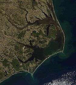
The Outer Banks is a string of peninsulas and barrier islands separating the Atlantic Ocean from mainland North Carolina. From north to south, the largest of these include: Bodie Island (which used to be an island but is now a peninsula due to tropical storms and hurricanes), Hatteras Island, Ocracoke Island, Portsmouth Island, and the Core Banks.[4] Over time, the exact number of islands and inlets changes as new inlets are opened up, often during a breach created during violent storms, and older inlets close, usually due to gradually sifting sands during the dynamic processes of beach evolution.
The Outer Banks stretch southward from Sandbridge in Virginia Beach down the North Carolina coastline. Sources differ regarding the southern terminus of the Outer Banks. Generations of North Carolina schoolchildren have learned that the term includes the state's three prominent capes: Cape Hatteras, Cape Lookout, and Cape Fear.[5][6] Other sources limit the definition to two capes (Cape Hatteras and Cape Lookout) and coastal areas in four counties (Currituck County, Dare County, Hyde County,and Carteret County).[7] Some authors include Carteret's Shackelford Banks and Bogue Banks in their descriptions,[7] while others exclude Bogue Banks.[8] Still other references restrict the definition to the northern three counties of Currituck, Dare, and Hyde.[9]
The abbreviations OBX (Outer Banks) and SOBX (Southern Outer Banks) are modern terms used to promote tourism and to market a variety of stickers, t-shirts, and other items to vacationers. OBX, which originated first, is generally used in the northern Outer Banks. SOBX is used primarily in Carteret County, which is also known as the Crystal Coast.
The northern part of the Outer Banks, from Oregon Inlet northward, is actually a part of the North American mainland, since the northern inlets of Bodie Island and Currituck Banks no longer exist.[10] It is separated by the Currituck Sound and the Intracoastal Waterway, which passes through the Great Dismal Swamp occupying much of the mainland west of the Outer Banks. Road access to the northern Outer Banks is cut off between Sandbridge and Corolla, North Carolina, with communities such as Carova Beach accessible only by four-wheel drive vehicles. North Carolina State Highway 12 links most of the popular Outer Banks communities in this section of the coast. The easternmost point is Cape Point at Cape Hatteras on Hatteras Island, site of the Cape Hatteras Lighthouse.
The Outer Banks are not anchored to offshore coral reefs like some other barrier islands and as a consequence they often suffer significant beach erosion during major storms. In fact, their location jutting out into the Atlantic makes them the most hurricane-prone area north of Florida, for both landfalling storms and brushing storms offshore. Hatteras Island was cut in half on September 18, 2003, when Hurricane Isabel washed a 2,000 foot (600 m) wide and 15 foot (5 m) deep channel called Isabel Inlet through the community of Hatteras Village on the southern end of the island.[11] The tear was subsequently repaired and restored by sand dredging by the U.S. Army Corps of Engineers. It was cut off once again in 2011 by Hurricane Irene. Access to the island was largely limited to boat access only from August to late October until another temporary bridge could be built.
Vegetation
The vegetation of the Outer Banks varies. In the northeast part of the Outer Banks, from Virginia Beach southward past the North Carolina border to Oregon Inlet, the main types of vegetation are sea grasses, beach grasses and other beach plants including Opuntia humifusa on the Atlantic side and wax myrtles, bays, and grasses on the Sound side with areas of pine and Spanish moss-covered live oaks. Yucca aloifolia and Yucca gloriosa can be found growing wild here in the northern parts of its range on the beach. Sabal Minor palms were once indigenous to the entire Outer Banks, and they are still successfully planted and grown. Its current most northerly known native stand is on Monkey Island in Currituck County.[12][13]
From Cape Hatteras National Seashore southward, the vegetation includes that of the northeastern Outer Banks. Sabal minor and Yucca aloifolia as well as Cabbage palmetto (Sabal palmetto), which can be found in the north, although they are native in the southern part of the Outer Banks. Pindo palms and windmill palms are also planted widely throughout the Outer Banks; although, they are not indigenous to the area.
A wide variety of native plants can be found at the Elizabethan Gardens in Manteo on Roanoke Island.[14] The gardens are open year round, 7 days a week.
Weather
The Outer Banks have unusual weather patterns because of their unique geographical location. As the islands are jutted out from the eastern seaboard into the Atlantic Gulf Stream, the Outer Banks has a predisposition to be affected by hurricanes, Nor'easters (usually in the form of rain, and rarely snow or mixed precipitation), and other ocean-driven storms.
The winters are typically milder than in inland areas, averaging lows in the upper 30s and highs in the lower 50s, and is more frequently overcast than in the summer. However, the exposure of the Outer Banks makes them prone to higher winds, often causing wind chills to make the apparent temperature as cold as the inland areas. The summer months average lows from the mid-70s to highs in the upper 80s, depending on the time of the summer. The spring and fall are typically milder seasons. The fall and winter are usually warmer than areas inland, while the spring and the summer are often slightly cooler because of the moderating effects of being surrounded by water.
Although snow is possible, averaging from 3 inches in the north to less than 1/2 inch per year in the south, there are many times when years pass between snowfalls.[15] The majority of nor'easters are "born" off the coasts of the Outer Banks.
Culture

The Outer Banks were first settled by English European colonial settlers, many of whom still have descendants living on the islands to this day. Before bridges were built in the 1930s, the only form of transport between or off the islands was by boat, which allowed for the islands to stay isolated from much of the rest of the mainland. This helped to preserve the maritime culture and the distinctive Outer Banks accent or brogue, which sounds more like an English accent than it does an American accent. Many "bankers" have often been mistaken for being from England or Ireland when traveling to areas outside of the Outer Banks. The brogue is more distinctive the further south one travels on the Outer Banks, with it being the thickest on Ocracoke Island and Harkers Island.
Some residents of the Outer Banks, known as wreckers, made part of their living by scavenging wrecked ships — or by luring ships to their destruction. Horses with lanterns tied to their necks would be walked along the beach; the lanterns' up and down motion would appear to ships to represent clear water and a ship ahead; the unsuspecting captain would then drive his ship ashore following this false light.[16]
The islands are home to herds of feral horses, sometimes called "banker ponies," which according to local legend are descended from Spanish Mustangs washed ashore centuries ago in shipwrecks. Populations are found on Ocracoke Island, Shackleford Banks, Currituck Banks, and in the Rachel Carson Estuarine Sanctuary.
Ocracoke was the last refuge of pirate Edward Teach, better known as Blackbeard. It is also where the infamous pirate was killed November 22, 1718 in a fierce battle with troops from Virginia.[17]
The Outer Banks is home to Yaupon Holly (Ilex vomitoria), the roasted leaves of which were brewed into a high caffeine beverage called black drink by the Native Americans. The Outer Banks may be one of the few places where it is still consumed.
Fishing
The Outer Banks offers a multitude of fishing options for tourists as well as locals.[18] There has been a long history of fishing in the Outer Banks, dating back to the end of the 17th century.[19] Pirates ravaged the coast for the majority of the 1600s, but once they were ridden, the local settlers used fishing as their lifeline.[19] Then, in the mid-19th century, large-scale commercial fishing erupted, mostly due to the construction of the Albemarle and Chesapeake Canal, which simplified shipping methods for fishermen.[19] Saltwater fishing became the cash-crop of the Outer Banks, and blossomed it into a popular tourist destination.[19] In modern times, tourists will flock to the area just for the abundance of fishing opportunities.[18] Anglers, otherwise known as fishermen, have a wide range of fishing methods, some of these methods date back to when the first settlers arrived, to choose from in the Outer Banks.[19]
- Fly fishing
- This was brought about in the 1950s when modern fly fishing experts like, Joe Brooks and Jimmy Albright, were successfully catching a variety of gamefish on the flats of the Florida Keys and on the Currituck Sound, which is included in the stretch of the Outer Banks.[20] Modern fly fishers in the Outer Banks pursue a variety of gamefish from red drum, to marlin and tuna.[20]
- Brackish fishing
- This is a separate type of fishing than complete saltwater because of the abundance of new species that are able to live in brackish water.[21] The Outer Banks has multiple Sounds that receive water from the Atlantic Ocean and many North Carolina fresh-water rivers, creating an estuary for many types of fish including, striped bass, puppy drum, and speckled trout.[21]
- Offshore fishing
- Thriving in the Outer Banks, this is the type of fishing this area is known for.[18] Offshore fishing is the method of heading out to sea to the Gulf Stream, where giant species such as billfish, tuna and dolphin lurk.[22] Anglers can book charters or use their own personal boat, but a larger boat is necessary to reach the deep water where the big fish are prevalent.[18]
- Inshore fishing
- Guides local to the Outer Banks will often escort new anglers around the area to sounds and piers where they are guaranteed a catch.[23] Whether the customer is a novice or veteran with their fishing skills, the inshore guide is someone that is there to help.[23]
- Pier fishing
- The Outer Banks are one of the few coastal areas left with more than one fishing pier along the coast, so anglers attract to the area for an opportunity to pier fish.[24] Pier Fishing is an easy way for anglers to get a little off-shore mixed with some inshore fishing.[24] It is where fishermen can catch any type of fish they please, as long as it is the season for it.[24]
The Outer Banks are a popular destination for bottom fish like spot and mullet, these two types of fish are caught throughout the year.[25] The peak for fishing bottom and top water feeders is early to the middle of May.[25] If the angler is solely searching for top water fish, then late May and June would be the ideal time to fish, especially if they are searching for Mackerel.[25] In the offseason, or winter months, the true fishermen are out searching for Trout, Sea Bass, Bluefish, Bluefin Tuna, Oysters, King Mackerel, Bay Scallops, and Striped Bass.[22] In the spring, the popular catches are Grouper, Sea Trout, Sea Bass, Bluefish, Bluefin and Yellowfin tuna, Oysters, Snapper, Striped Bass, Red Drum, Croaker, Sea Mullet, King Mackerel, and Wahoo[22] Late Spring and the beginning of summer is the favored time for top-water fish to move-in to the coastal waters near the Outer Banks, because of the warming waters and the increased visibility in the water[25] The top water fish can see baitfish easily due to the decrease in murky water[25] Plus they will start to migrate back North as the coastal waters to the south become too hot, the waters farther North will warm to their desired temperatures.[25] Yet, in the prime tourist season of the summer, fishermen and many tourists have plenty of game options such as blue Marlin, White Marlin, Dolphin, Wahoo, Cobia, King Mackerel, Bluefish, Tuna, Flounder, snapper, Grouper, Spanish Mackerel, Crabs, Soft Crabs, Shrimp, Spot, Croaker, Sailfish, and Sea Mullet.[18] By the fall, most tourists have started to leave, but fishermen are still out searching for Snapper, Channel Bass, Bluefish, King Mackerel, Grouper, Tuna, Oysters, Striped Bass, Sea Mullet, Spot, Clams, Speckled Trout, Flounder, and Shrimp.[18] The prime season for fall fishing is late September to October 23.[25] Though the water is more turbulent and murky due to the strong northeast prevailing winds, there is still some big game fish left.[25] Most of these fish are vacating back to the South for the warm waters.[18] This makes it a prime time for smaller bottom fish who love to feed in murky, colder water.[25]
Communities
Towns and communities along the Outer Banks include (listed from north to south):
Currituck Banks
Bodie Island

Roanoke Island
Hatteras Island
Ocracoke Island
Bogue Banks
Parks

- Back Bay National Wildlife Refuge
- Cape Hatteras National Seashore
- Cape Lookout National Seashore
- Currituck Heritage Park
- Currituck National Wildlife Refuge
- False Cape State Park
- Fort Macon State Park
- Fort Raleigh National Historic Site
- Jockey's Ridge State Park
- Mackay Island National Wildlife Refuge
- Pea Island National Wildlife Refuge
- Wright Brothers National Memorial
Notable residents
- Andy Griffith (1926–2012), actor[26]
- Dennis Anderson, professional Monster Truck driver and creator of Grave Digger.
See also

- Crystal Coast (Southern Outer Banks)
- Hazard mitigation in the Outer Banks
- Inner Banks
- North Carolina Highway 12
- Outer Banks Daredevils
- Historic Albemarle Tour
References
- ↑ "Campgrounds". Retrieved 1 April 2016.
- ↑ See National Park Service: Fort Raleigh National Historic Site
- ↑ "Telegram from Orville Wright in Kitty Hawk, North Carolina, to His Father Announcing Four Successful Flights, 1903 December 17". World Digital Library. 1903-12-17. Retrieved 2013-07-21.
- ↑ "Geography of North Carolina". NC State Board of Education.
- ↑ "Geography of North Carolina". www.ncpublicschools.org. Retrieved 2016-04-09.
- ↑ "Library of Congress LCCN Permalink sh85096155". lccn.loc.gov. Retrieved 2016-04-10.
- 1 2 "North Carolina Gazetteer | NCpedia". ncpedia.org. Retrieved 2016-04-10.
- ↑ "Outer Banks | island chain, United States". Encyclopedia Britannica. Retrieved 2016-04-10.
- ↑ "Outer Banks Map - OuterBanks.com". www.outerbanks.com. Retrieved 2016-04-10.
- ↑ "Corolla History". Retrieved 1 April 2016.
- ↑ "Shoring Up N. Carolina Islands: A Losing Battle?". Retrieved 1 April 2016.
- ↑ "Monkey Island Sabal Minor". Old Dominion University. Retrieved 1 November 2013.
- ↑ "Gary's Nursery". Gary Hollar. Retrieved 1 November 2013.
- ↑ "Elizabethan Gardens - Outer Banks Attractions - Relaxing Vacation Activities". Retrieved 1 April 2016.
- ↑ "BACK BAY WILDLIFE REFUG, VIRGINIA - Climate Summary". Retrieved 1 April 2016.
- ↑ "Graveyard of the Atlantic - North Carolina Digital History". Retrieved 1 April 2016.
- ↑ D. Moore. (1997) "A General History of Blackbeard the Pirate, the Queen Anne's Revenge and the Adventure". In Tributaries, Volume VII, 1997. pp. 31–35. (North Carolina Maritime History Council)
- 1 2 3 4 5 6 7 "Outer Banks Fishing". The Outer Banks of North Carolina. Retrieved 21 January 2016.
- 1 2 3 4 5 "Gloucester vs. Outer Banks". National Geographic Channel. Retrieved 1 April 2016.
- 1 2
- 1 2 "Fishing Opportunities in the Coastal Region of North Carolina". Retrieved 1 April 2016.
- 1 2 3 "The Outer Banks in Winter". Field & Stream. Retrieved 1 April 2016.
- 1 2 "Outer Banks Charter Fishing". Retrieved 1 April 2016.
- 1 2 3 "North Carolina's Ocean Piers". VisitNC.com. Retrieved 1 April 2016.
- 1 2 3 4 5 6 7 8 9 Jonathan Finch. "Pier Fishing on the Outer Banks". Retrieved 1 April 2016.
- ↑ Vincent, Mal (February 17, 2008). "The real Andy Griffith lives among us, quietly". The Virginian-Pilot. Retrieved September 20, 2009.
External links
| Wikimedia Commons has media related to Outer Banks. |
 Outer Banks travel guide from Wikivoyage
- Outer Banks Visitors Bureau Dare county
- College of The Albemarle
Coordinates: 35°22′25″N 75°29′43″W / 35.37365°N 75.49530°W