Hartselle–Morgan County Regional Airport
| Hartselle–Morgan County Regional Airport Rountree Field | |||||||||||
|---|---|---|---|---|---|---|---|---|---|---|---|
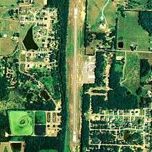 NAIP aerial image, 24 August 2006 | |||||||||||
| IATA: none – ICAO: none – FAA LID: 5M0 | |||||||||||
| Summary | |||||||||||
| Airport type | Public | ||||||||||
| Owner | City of Hartselle | ||||||||||
| Serves | Hartselle, Alabama | ||||||||||
| Elevation AMSL | 628 ft / 191 m | ||||||||||
| Coordinates | 34°24′30″N 086°55′59″W / 34.40833°N 86.93306°W | ||||||||||
| Runways | |||||||||||
| |||||||||||
| Statistics (2009) | |||||||||||
| |||||||||||
Hartselle–Morgan County Regional Airport (FAA LID: 5M0) is a public-use airport located two nautical miles (4 km) south of the central business district of Hartselle, a city in Morgan County, Alabama, United States.[1] The airport was formerly known as Rountree Field, named in the 1960s for Asa Rountree Sr., a former head of the Alabama Department of Aeronautics.
James Embry Stone Jr. was one of the founders and developers of the airport. He and his wife Dorothy Patricia Scott Stone were real estate developers that co-developed two subdivisions in the Hartselle area. He owned a lumber company and saw mill. He was a church deacon. He traveled internationally to Scotland, Denmark, England, Germany, Italy, Austria, Switzerland, Mexico, Argentina, and France. He was a Rotarian governor for Alabama and a Paul Harris Fellow. His older brother William (Bill) Stone lived in nearby town of Decatur and loved to fly planes. [2]
This airport is included in the FAA's National Plan of Integrated Airport Systems for 2011–2015[3] and 2009–2013,[4] both of which categorized it as a general aviation facility.
Facilities and aircraft
Hartselle–Morgan County Regional Airport covers an area of 62 acres (25 ha) at an elevation of 628 feet (191 m) above mean sea level. It has one runway designated 18/36 with an asphalt surface measuring 3,599 by 75 feet (1,097 x 23 m).[1]
For the 12-month period ending July 2, 2009, the airport had 15,295 general aviation aircraft operations, an average of 41 per day. At that time there were 20 aircraft based at this airport: 75% single-engine, 15% multi-engine, 5% jet and 5% helicopter.[1]
See also
References
- 1 2 3 4 FAA Airport Master Record for 5M0 (Form 5010 PDF). Federal Aviation Administration. Effective 25 August 2011.
- ↑ "FAA OKs Hartselle airport name change". The Decatur Daily. September 18, 2007.
- ↑ "2011–2015 NPIAS Report, Appendix A (PDF, 2.03 MB)" (PDF). 2011–2015 National Plan of Integrated Airport Systems. Federal Aviation Administration. 4 October 2010. External link in
|work=(help) - ↑ "2009–2013 NPIAS Report, Appendix A: Part 1 (PDF, 1.33 MB)" (PDF). 2009–2013 National Plan of Integrated Airport Systems. Federal Aviation Administration. 15 October 2008. External link in
|work=(help)
External links
- Aerial image as of 6 March 1997 from USGS The National Map
- FAA Terminal Procedures for 5M0, effective November 10, 2016
- Resources for this airport:
- FAA airport information for 5M0
- AirNav airport information for 5M0
- FlightAware airport information and live flight tracker
- SkyVector aeronautical chart for 5M0