St. Clair County Airport
| St. Clair County Airport | |||||||||||
|---|---|---|---|---|---|---|---|---|---|---|---|
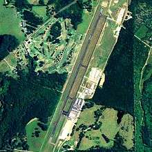 NAIP aerial image, 2006 | |||||||||||
| IATA: PLR – ICAO: KPLR – FAA LID: PLR | |||||||||||
| Summary | |||||||||||
| Airport type | Public | ||||||||||
| Owner | St. Clair County Airport Authority | ||||||||||
| Serves | Pell City, Alabama | ||||||||||
| Elevation AMSL | 485 ft / 148 m | ||||||||||
| Coordinates | 33°33′32″N 086°14′57″W / 33.55889°N 86.24917°W | ||||||||||
| Website | www.PLRairport.com | ||||||||||
| Runways | |||||||||||
| |||||||||||
| Statistics (2009) | |||||||||||
| |||||||||||
St. Clair County Airport (IATA: PLR, ICAO: KPLR, FAA LID: PLR) is a public use airport located three nautical miles (6 km) southeast of the central business district of Pell City, in St. Clair County, Alabama, United States. It is owned by the St. Clair County Airport Authority.[1] According to the FAA's National Plan of Integrated Airport Systems for 2009–2013, it is categorized as a reliever airport.[2] for the Birmingham-Shuttlesworth International Airport.[1]
Facilities and aircraft
St. Clair County Airport covers an area of 200 acres (81 ha) at an elevation of 485 feet (148 m) above mean sea level. It has one runway designated 3/21 with an asphalt surface measuring 5,001 by 80 feet (1,524 x 24 m).[1]
For the 12-month period ending January 22, 2009, the airport had 34,572 aircraft operations, an average of 94 per day: 97% general aviation and 3% military. At that time there were 81 aircraft based at this airport: 85% single-engine, 12% multi-engine, 1% helicopter and 1% ultralight.[1]
Sammies Touch-n-Go restaurant is located on the North end of the airport.
Holder Aviation, an avionics repair and installation company, is based at the airport.
References
- 1 2 3 4 5 FAA Airport Master Record for PLR (Form 5010 PDF). Federal Aviation Administration. Effective 3 June 2010.
- ↑ National Plan of Integrated Airport Systems for 2009–2013: Appendix A: Part 1 (PDF, 1.33 MB). Federal Aviation Administration. Updated 15 October 2008.
External links
- Saint Clair County Airport
- Aerial image as of 6 March 1997 from USGS The National Map
- Airfield photos for PLR from Civil Air Patrol
- FAA Terminal Procedures for PLR, effective December 8, 2016
- Resources for this airport:
- FAA airport information for PLR
- AirNav airport information for PLR
- ASN accident history for PLR
- FlightAware airport information and live flight tracker
- SkyVector aeronautical chart for PLR