Blackwell Field
| Blackwell Field | |||||||||||
|---|---|---|---|---|---|---|---|---|---|---|---|
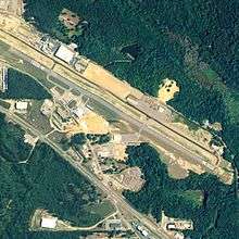 NAIP aerial image, 2006 | |||||||||||
| IATA: none – ICAO: none – FAA LID: 71J | |||||||||||
| Summary | |||||||||||
| Owner | Town of Ozark | ||||||||||
| Serves | Ozark, Alabama | ||||||||||
| Elevation AMSL | 356 ft / 109 m | ||||||||||
| Coordinates | 31°25′55″N 085°37′14″W / 31.43194°N 85.62056°W | ||||||||||
| Runways | |||||||||||
| |||||||||||
| Statistics (2010) | |||||||||||
| |||||||||||
Blackwell Field (FAA LID: 71J) is a public-use airport located two nautical miles (2.3 mi, 3.7 km) southeast of the central business district of Ozark, in Dale County, Alabama, United States. The airport is owned by the Town of Ozark.[1] It is included in the FAA's National Plan of Integrated Airport Systems for 2011–2015, which categorized it as a general aviation facility.[2]
Facilities and aircraft
Blackwell Field covers an area of 114 acres (46 ha) at an elevation of 356 feet (109 m) above mean sea level. It has one runway designated 12/30 with an asphalt surface measuring 5,152 by 80 feet (1,570 x 24 m).[1]
For the 12-month period ending March 4, 2010, the airport had 91,500 general aviation aircraft operations, an average of 250 per day. At that time there were 26 aircraft based at this airport: 58% single-engine, 15% multi-engine, 4% jet and 23% helicopter.[1]
References
- 1 2 3 4 FAA Airport Master Record for 71J (Form 5010 PDF). Federal Aviation Administration. Effective 30 June 2011.
- ↑ National Plan of Integrated Airport Systems for 2011–2015: Appendix A (PDF, 2.03 MB) Archived September 27, 2012, at the Wayback Machine.. Federal Aviation Administration. Updated 4 October 2010.
External links
- FAA Terminal Procedures for 71J, effective November 10, 2016
- Resources for this airport:
- FAA airport information for 71J
- AirNav airport information for 71J
- FlightAware airport information and live flight tracker
- SkyVector aeronautical chart for 71J