Garden State Parkway
| ||||
|---|---|---|---|---|
 | ||||
| Route information | ||||
| Maintained by the New Jersey Turnpike Authority | ||||
| Length: | 172.40 mi[1] (277.45 km) | |||
| Existed: | 1947 – present | |||
| Restrictions: | No commercial vehicles north of exit 105[2] | |||
| Major junctions | ||||
| South end: |
| |||
| ||||
| North end: |
G.S. Pkwy. Connector to | |||
| Location | ||||
| Counties: | Cape May, Atlantic, Burlington, Ocean, Monmouth, Middlesex, Union, Essex, Passaic, Bergen | |||
| Highway system | ||||
| ||||

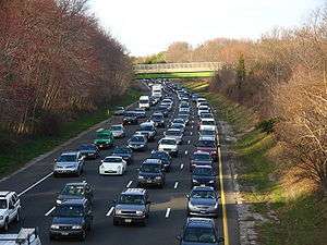
The Garden State Parkway (GSP) is a 172.4-mile (277.5 km)[1] limited-access toll parkway that stretches the length of New Jersey from the New York line at Montvale to Cape May at the state's southernmost tip. Its name refers to New Jersey's nickname, the "Garden State". Most New Jerseyans refer to it as simply "the Parkway". The parkway's official, but unsigned, designation is Route 444. At its north end, the parkway becomes the Garden State Parkway Connector, a component of the New York State Thruway system that connects to the Thruway mainline in Ramapo. The Parkway has been ranked as the busiest toll highway in the country based on the number of toll transactions.[3][4] The parkway is the longest highway in the state.
Route description

The Garden State Parkway begins in Lower Township at an interchange with Route 109 (traffic light at the southbound terminus, which is signed as exit 0 on the southbound portion).[1]
For the first 3 1⁄2 miles (5.6 km), the parkway crosses over streams. At 3.48 miles (5.60 km), the parkway crosses over Taylor Creek and enters Middle Township. Exit 4 is for Route 47 north to Rio Grande and Wildwoods.[1] At 6.54 miles (10.53 km), parkway exit 6, for Route 147 and North Wildwood, leaves to the right of the southbound lanes; there is no northbound exit, only an entrance, and no southbound entrance.
Previously, there were three at-grade interchanges (traffic lights) for exits 9, 10, and 11. Construction on overpasses began in 2013 and was completed in 2016. The first is at exit 9 to Shellbay Avenue. The second is exit 10 to County Route 657 (CR 657), also known as Stone Harbor Boulevard. The Cape Regional Medical Center, the county's only hospital, is at this exit. Exit 11 is for U.S. Route 9 (US 9) at the Cape May County Park & Zoo. An unsigned southbound exit and entrance at East Mechanics Street was removed in August 2011, between exits 9 and 10. In May 2009, guardrails were installed in between the northbound and southbound lanes from mile markers 7 to 11.5, due to the previous year's many fatal head-on crashes resulting from cars crossing the median. The at-grade interchanges were reconstructed to put the parkway on overpasses above those roads, completed in July 2015. Because this work is finished, there are no longer any traffic lights or other intersections on the entire length of the parkway.
Exit 13 is for Avalon Boulevard. At 14.85 miles (23.90 km), the parkway enters Dennis Township after crossing Uncle Aaron's Creek. At 17.5 miles (28.2 km), exit 17 leaves to the right for CR 625.[1] At milepost 19.38, the parkway enters its first toll, the Cape May Toll Plaza. A little more than 20 miles (32 km) in, exit 20 leaves for Route 50. In Upper Township, exit 25 leaves for CR 623. At 27.77 miles (44.69 km), the parkway enters Atlantic County.[1]
Just before exit 29 (northbound only) for US 9, the parkway enters the Great Egg Toll Plaza.[1] Exit 30 (southbound only) leaves to the right at milepost 30 for Laurel Road in Somers Point which leads to Ocean City via the Route 52 causeway. Now in Egg Harbor Township, exit 36 opens onto CR 563 southbound and CR 651 northbound. The northbound exit 36 serves as (indirect) access to the Black Horse Pike (US 40/US 322). Exit 37 (southbound) is the parkway's interchange with CR 608. This exit serves as (indirect) access from the southbound parkway to the Black Horse Pike (US 40/US 322) and the northbound direction of CR 563. Exit 38 connects with the Atlantic City Expressway. Eastbound travelers on the expressway take the last few miles to Atlantic City. Westbound travelers head for Camden and Philadelphia. Now entering Galloway Township, US 30 connects with the parkway at exit 40.[1] Exit 41 is next, connecting to CR 561. Exit 44 follows after Exit 41, leading to CR 561 Alternate (CR 561 Alt.)and CR 575. Just after exit 48 for US 9 near the Mullica River and Bass River State Forest, the parkway enters Burlington County. Exit 50 is for US 9 as well, while exit 52 is for CR 654.
.jpg)
Now in Ocean County, exit 58 is for CR 539, exit 63 is for Route 72, and exit 67 is for CR 554. Exit 69 leaves to the right in both directions at milepost 70.45. Exit 74 leaves to the right, which heads to Forked River. Exit 77 is for Bayville. Exits 80 (southbound only) is for county roads and US 9. US 9 then merges in for a few miles.[1]
Between exits 80 and 83, the parkway runs concurrently with US 9 just south of the Toms River Toll Plaza. It was from here that the Driscoll Expressway was to start (south of exit 83) and run to the New Jersey Turnpike.
CR 527 connects with the parkway at exit 81. Route 37 connects with the parkway at exits 82 and 82A in Toms River.[1] At exit 83 (northbound only), US 9 leaves the parkway and heads north. Exit 89 comes at 89.4 miles (143.9 km) for Route 70 and CR 528. In Brick Township, exit 90 (northbound) and exit 91 (southbound), leave for CR 549. At this point the road is in Monmouth County. Exit 98 leads to Interstate 195 (I-195), Route 34 and Route 138. Exit 100 leaves southbound for Route 33. Route 66 also exits northbound. Exit 102, a southbound-only exit leaves for Neptune Township.[1]
Exit 105 for Route 18 (northbound only) and Route 36 leading to Long Branch is the point at which all trucks are forced to leave the parkway.[2] At exit 105, the parkway divides into a local–express lane configuration.[1] The express lanes have no direct access to any exits, except for exit 105 in Tinton Falls (southbound only) and exit 117 in Hazlet. Exits 109 and 114 are for Red Bank and Holmdel. The next exit, exit 116, is for the PNC Bank Arts Center in Holmdel. Exit 117 is for Route 35 and Route 36. Exit 118 (southbound only) is for Lloyd Road in Aberdeen. Exit 120 is for Laurence Harbor Road and Cheesequake State Park.
At this point, the road enters Middlesex County in Old Bridge Township. Southbound exits 123 and 124 leave to the right, but only on the local lanes. The express and local lanes merge and become one highway again shortly after. Northbound exit 125 makes a sudden exit for Route 35.[1] Afterwards, the route crosses the Driscoll Bridge over the Raritan River. After the bridge, exit 127 leaves for Route 9, Route 440 and I-287. At milepost 129.5, the New Jersey Turnpike leaves to the right at exit 129. Southbound exits 127 and 129 are merged into one exit, which is marked as exit 129. A southbound-only exit, exit 130 is for US 1. The next three exits are marked 132 (complete), 131A (complete), and 131B (northbound only). The lettered ones are for Metropark, while exit 132 is for Route 27.

Exit 135 is for Clark Township in Union County.[1] Exits 136 and 137 are for Cranford Township and Route 28. Exit 138 is in Kenilworth for CR 509. Exits 139A and 139B are northbound exits only for a local road (Chestnut Street) and US 22. Exits 140 and 140A are for US 22 and Route 82. Exit 141 is for Vauxhall Road and the 142s are for I-78.[1] The 143s are for Lyons Avenue, exit 144 is for Irvington and 145 is for I-280. Exit 147 is for Springdale Avenue in East Orange, and exit 148 is for Bloomfield Avenue in Bloomfield. Exits 149, 150, and 151 are for Essex County roads.[1] Exits 153A and 153B are for Route 3 and US 46 in Passaic County.
As the parkway leaves Clifton, it heads into Elmwood Park by crossing the Passaic River. Exit 156, which comes before the river, is for US 46 and Route 20. There is also access to Route 21 just south of the interchange. Cedar Lawn Cemetery is also located northbound along Route 20 from exit 156. As the parkway continues to the northeast, it connects with US 46 again in Garfield. Riverside Cemetery is accessible off exit 157 by going east along US 46. At exit 159, the parkway connects with I-80 in Saddle Brook. Going southbound, there is also access to CR 67 (Midland Avenue). The Bergen Toll Plaza is next, before crossing over Saddle River County Park.
Exit 160 comes next, as the parkway enters Paramus and connects with West Passaic Street, which heads to Route 208. Not far afterwards, at exit 161 (northbound) is Route 4. Westfield Garden State Plaza is visible from the parkway and is off exit 161. Exit 163 is for Route 17 in Paramus, which heads north to Ridgewood, Saddle River, Upper Saddle River, Ramsey and Mahwah before entering Rockland County, New York (on the southbound side of the parkway, the exit is for Route 17 south toward the Meadowlands area and Hudson County). The parkway goes between Paramus Park Mall and Bergen Regional Medical Center as it heads north. Just after, exit 165 intersects for CR 80 (Oradell Avenue and East Ridgewood Avenue) in Paramus. The parkway turns to the northwest and heads into the Pascack Valley Toll Plaza going northbound. There is a plaza southbound along the parkway as well as exit 166 for CR 110 (Linwood Avenue).

As the parkway inches closer and closer to New York, exit 168 comes along, connecting to CR 502, which heads towards Ho-Ho-Kus and Alpine. Three miles (4.8 km) later, at exit 171, the parkway connects with Glen Road, which terminates soon after at Chestnut Ridge Road (CR 73). The parkway's Montvale Service Area comes at milepost 171 after exit 172 which is for CR 94. There is also access to CR 94 from the Montvale Service Area's service road. At 172.4 miles (277.5 km), the parkway becomes the Garden State Parkway Connector at the New York state line.[1]
Spur routes
Two short spurs are given numbers by the New Jersey Department of Transportation (NJDOT). Route 444R is the connector at exit 117 (in Hazlet) to Route 35 at the north end of Route 36 in Keyport. Route 444S is the connector at exit 105 to the south end of Route 36 at Hope Road (CR 51) near Eatontown.
Emergency assistance
On the Garden State Parkway, the emergency assistance number is #GSP, which is #477 in number form. New Jersey State Police are the primary police agency that handles calls for service on the parkway. Other emergency services such as fire and first aid are usually handled by the jurisdictions in which that section of the parkway passes.
History
.svg.png)


Route S101 was a northern extension of Route 101 planned from Hackensack through Paramus to the New York state line near Montvale. The section from Hackensack to Paramus was never built; the section from Paramus to the state line would become part of the Garden State Parkway.
The parkway was originally designated as the Route 4 Parkway when it was started in 1947 in Union County, but, due to lack of funds, only 11 miles (18 km) were completed by 1950. The solution was for the state to establish the New Jersey Highway Authority in 1952 to oversee construction and operation as a self-liquidating toll road.[5] Much of the original section, between exits 129 and 140, was long administered by the New Jersey Department of Transportation and has always been untolled. The segment can be distinguished by the stone facing on the overpasses.
The parkway was constructed between 1946 and 1957 to connect suburban northern New Jersey with resort areas along the Atlantic coast and to alleviate traffic on traditional north–south routes running through each town center, such as US 1, US 9, and Route 35. Unofficially, it has two sections: the "metropolitan section" north of the Raritan River and the "shore section" between the Raritan River and Cape May. Only 18 miles (29 km) had been constructed by 1950, but taking a cue from the successful New York State Thruway, on April 14, 1952, the New Jersey Legislature created the New Jersey Highway Authority, empowered to construct, operate, and maintain a self-sufficient toll parkway from Paramus to Cape May.
The landscape architect and engineer in charge of the newly named Garden State Parkway was Gilmore David Clarke, of the architectural firm of Parsons, Brinkerhof, Hall and MacDonald,[5] who had worked with Robert Moses on the parkway systems around New York City. Clarke's design prototypes for the parkway combined the example of the Pennsylvania Turnpike, a model of efficiency with parallels in the German Autobahn routes of the 1930s, with the Merritt Parkway model that stressed a planted "green belt" for beauty. Both design models featured wide planted medians to prevent head-on collisions and mask the glare of oncoming headlights. The Garden State Parkway was designed to have a natural feel. Many trees were planted, and the only signs were those for exits—there were no distracting billboards. Most of the signs were constructed from wood, or a dark-brown metal, instead of the chrome bars used on most other highways. The guardrails were also made from wood and dark metal. Most early overpasses were stone, but then changed to concrete, with green rails and retro etchings, popular around the 1950s and 1960s. These are now in decay and being replaced by sleek, new bridges. The parkway was designed to curve gently throughout its length so that drivers would remain alert and not fall asleep at the wheel.
Most of the metropolitan section is like any other expressway built in the 1950s through heavily populated areas. The shore section parallels US 9 and runs through unspoiled wilderness in the New Jersey Pine Barrens. In Cape May County, the parkway had three traffic lights (at exits 9, 10, and 11 respectively), but these were eliminated in 2015, with construction of an overpass at exit 10 in Cape May Court House and Stone Harbor.
The parkway had an old alignment before the Great Egg Harbor Bridge was completed. It was detoured onto US 9 and over the Beesley's Point Bridge. That bridge is currently under demolition.
The Garden State Parkway was off-limits to motorcycles until Malcolm Forbes pushed successfully for legislation to allow them.[6]
On July 9, 2003, Governor Jim McGreevey's plan to merge the operating organizations of the Garden State Parkway and the New Jersey Turnpike into one agency was completed.[7]
Literature from the time of the parkway's construction indicates that the parkway would become toll-free once bonds used for its construction were paid off. However, additional construction projects, plus the expectation that the parkway will pay for its own maintenance and policing (and the massive E-ZPass project) make it unlikely it will become toll-free in the foreseeable future.
The parkway was also planned to be the southern terminus for Route 55 at milemarker 19. This was cancelled after the conclusion that the highway ran through too many wetland areas. The idea is still being revisited after frequent traffic jams on Route 47.
On July 22, 2014, the New Jersey Turnpike Authority filed a federal lawsuit against Jersey Boardwalk Pizza, a pizza chain in Florida, for using a logo too similar to the signs for the Garden State Parkway.[8]
Later construction
- In the first half of the 1980s, exit 171 was added in Woodcliff Lake, serving the mushrooming office complexes replacing farmland along nearby Chestnut Ridge Road.[9]
- On May 1, 1993, a travel center was opened at the Montvale Service Area, replacing one that burned to the ground in 1991.[10]
- In 2003, the Lakewood section received a brand-new southbound exit and northbound entrance, exit 89. In order to expand the parkway for the interchange, the Cedar Bridge Road bridge had to be torn down and rebuilt. The whole project was completed in November 2003 and cost about $16.23 million.[11]
- In Waretown, a $16.4 million project was completed for new bridges at exit 69. The construction was completed in March 2007. Along with the new interchange came two new toll plazas. The Parkway was widened at the location it goes under CR 532.[12]
- The same company who did the exits 69 and 89 construction had also done work on exit 100, 20 years before the exit 69 construction. That project included demolishing all then-current bridges and building new ones along the newly rerouted Route 66 and Route 33. This project, in Tinton Falls, cost $21.67 million to complete.[13]
- Installation of variable message signs along the parkway began 1992 with the installation of approximately 25 Daktronics signs. Some of these signs were installed on new sign structures while others were added to existing GO signs. Initially, the signs were provided with telephone service. A controller with a modem was installed in a cabinet near the signs. Messages on the signs were changed manually using software on personal computers in the GSP headquarters building in Woodbridge.
Recent developments
- The southern terminus of the roadway at exit 0 in Lower Township is being reconfigured to reduce accidents and congestion and improve traffic flow at the tricky merge with Route 109. The project will add a new traffic signal and turn lanes along with improving the flow of traffic coming from the Cape May–Lewes Ferry turning north onto the parkway. Construction is slated to be complete by the end of 2016.
- The southbound bridge over the Great Egg Harbor Bay was replaced with a wider span parallel to the older span. Construction began in 2013 and continued into 2016. The new southbound bridge will be built to carry both northbound and southbound traffic so the northbound bridge can receive new decking and strengthening. The project includes the demolition of the abandoned Beesley's Point Bridge parallel to the parkway, and the addition of mixed-use walkway along the new southbound parkway span that will allow pedestrian and bicycle connections between Upper Township and Somers Point.
- A $25 million interchange will be built as exit 41 at Jimmie Leeds Road, north of the Atlantic City service area. An access road currently connects the service area to Jimmie Leeds Road, which will be demolished and will be the future location of a new State Police facility. The project was completed in March 2015.[14]
- Exit 44 has been converted to a full interchange in Galloway Township, when the northbound exit and southbound entrance opened in August 2015.
- Governor Codey announced a widening of the parkway in May 2005 between exit 63 in Stafford Township to exit 80 in the borough of South Toms River. The new parkway setup would convert from the current two to become three lanes in both directions. However, the NJTA is now planning to widen the parkway from exit 80 all the way south to exit 30 in the city of Somers Point. As of 2015, the parkway widening project from exits 80 to 48 were complete while exits 48 to 30 as the third phase is underway.
- Exit 89A from the southbound lanes has been added for access to Route 70 east (Brick) and 89B was converted to access to Route 70 west (Lakewood/Lakehurst). Exit 89C will access to CR 528 towards Lakewood and Brick. Exit 89A from the northbound lanes is the access to Route 70 (Brick/Lakehurst) while exit 89B will access to CR 528 towards Lakewood. Southbound entrances and northbound exits were added to make Route 70 a full interchange which was completed on June 12, 2015.
- Exits 89 and 90 in Lakewood will be reconstructed with continuous auxiliary lanes. In the northbound direction, the on ramp from exit 89 will be continuous to the off ramp at exit 90 and in the southbound direction, the on ramp from exit 90 will be continuous to the off ramp at exit 89. Overhead signing will be installed and the ground mounted signing will be removed.
- Exit 67 received a newly constructed southbound entrance ramp, and a northbound exit ramp. On March 27, 2008, it was revealed that the new ramps would not have toll gates. Construction began in the middle of 2008 and opened on May 20, 2009.[15]
- Exit 69 (in Ocean Township) was completely reconstructed. The old ramps were demolished, and a partial cloverleaf was constructed in its place. It now features a southbound exit ramp and a northbound entrance ramp. Toll gates were constructed at the southbound exit and northbound entrance ramps. This was finished in March 2007.
- As of 2014, the section between exits 80 and 48 was widened from two to three lanes in both directions. There are three phases of the parkway widening. The first phase from exit 80 to 63 was complete in May 2011. The second phase from exit 63 to 48 was finished in July 2013. The third phase from exit 48 to 30 is underway and scheduled to be finished in either 2015 or 2016.
- A new diamond interchange, exit 77 (in Berkeley Township) was constructed in 2006. Toll gates exist at the southbound exit ramp and the northbound entrance ramp. To avoid destroying part of the Double Trouble State Park, the southbound interchange was constructed approximately 1⁄2 mile (0.80 km) north of the northbound interchange.
- Exit 88 was permanently closed on November 10, 2014, at 7:00 pm. Traffic for Route 70 will use a reconfigured exit 89. Drivers exiting from the southbound lanes at exit 89C for CR 528 (Lakewood/Brick) while 89A for Route 70 east (Brick) and 89B for Route 70 west (Lakewood/Lakehurst). On June 12, 2015, drivers exiting from the northbound lanes at exit 89A for Route 70 (Brick/Lakehurst) and 89B for CR 528 (Lakewood).
- At exit 98 in Wall Township, the overpasses carrying Route 138 and I-195 over the parkway have been replaced with newly constructed ones. This project was finished in late 2006. However, this project did not improve 195's exit 35 for Route 34.
- The Driscoll Bridge received a new southbound parallel span just west of the original span. This new southbound bridge boasts seven southbound lanes and emergency shoulders (currently the seventh lane is used as a northbound lane during rehab of the old spans). By 2010, a new northbound span will be constructed, consisting of eight northbound lanes and emergency shoulders.[16] On May 20, 2009, the Driscoll Bridge project was completed.[17]
- New overpasses and ramps were built at exit 145 in the City of East Orange to connect to I-280. New E-ZPass lanes were also built at the interchange toll gate.[18][19]
- Northbound at the Bergen Tolls and southbound at the Raritan Tolls are the only toll plazas that have the "Pay Ahead" lanes. The Bergen Toll Plaza have one pay ahead lane leading to a two right-lane toll plaza while the Raritan Toll Plaza have two pay ahead lanes leading to a four right-lane toll plaza.
- The parkway was widened in Wall Township from three to four lanes in the vicinity of exit 98 in both directions.
- On February 20, 2010, the Pascack Valley Toll Plaza in Washington Township began the one-way tolling program. With the northbound tolls being eliminated, the southbound tolls were doubled from $0.50 to $1.00.[20]
- Exit 142 (in Union Township and Hillside) was upgraded with new ramps that now supply what were then missing movements between the parkway and I-78, since I-278 was canceled between US 1–9 in Linden and the interchange for Route 24/I-78. On September 17, 2009, a new exit ramp (from the parkway north to I-78 west, signed as exit 142B, which resulted in the old exit 142A being designated as exit 142C, and the old exit 142 becoming exit 142A) was opened.[18] On December 10, 2010, the ramp between the southbound Garden State Parkway and eastbound I-78 opened (exit 142 southbound became exit 142B and the new one exit 142A).[21]
- Overpasses have been constructed to eliminate the only at-grade crossings along the entire main line of the parkway at exits 9, 10 and 11 in Middle Township. The traffic lights have been removed. Construction began in the winter of 2013, years after the scheduled start date due to a wetland mitigation plan that had not been approved by the federal government. The project cost $125 million, and was complete by Labor Day 2015.[22]
- New bridges have been built across the Mullica River from the city of Port Republic to Bass River Township. Construction began in 2009 and was complete in 2015 as part of the parkway widening project.[18]
- Exit 83 in Toms River has been reconfigured with improved northbound access via a new connector road/Lomell Lane.[23]
- Exit 91 (in Brick Township) was to be upgraded to a full interchange. Work started in 2013 and was slated for completion in July 2016.[16][18] However, the project was put on indefinite hold after a failure to raising the state's gas tax.[24]
Future
- Exit 36 will be reconstructed to add a southbound exit deceleration lane and an acceleration lane on Tilton Road. There will be an elevated flyover that will separate the traffic entering the parkway at exit 38 from the southbound traffic leaving the parkway at exit 37 at Washington Avenue. Work is expected to be completed in 2018.[25]
- Exit 83 could possibly get a southbound exit ramp.
- Exit 125 could possibly get a southbound exit and a northbound entrance.
- Exit 131A in Woodbridge Township will be upgraded with new ramps.
- Exit 151 in Bloomfield Township will completely replace the Watchung Avenue overpass structure and the parkway will receive full shoulders underneath the new structure.
- Exit 163 will be moved to the right side of the parkway instead of the left. This project started in 2014 and will be finished by 2017.
- Exit 105 southbound in Eatontown south will possibly have a ramp to Wayside Road, providing (indirect) access to Route 18.
- The lanes between milepost 107 and exit 105 will be widened.
Usage
The speed limit on the parkway is 65 mph (105 km/h) with the following exceptions: 55 mph (89 km/h) between mileposts 123.5 and 163.3, 55 mph (89 km/h) between mileposts 80.0 and 85.2, and 45 mph (72 km/h) between mileposts 27 and 29, approaching and traversing the Great Egg Harbor Bridge, and between milepost 126.7 and 127.7, approaching and traversing the Driscoll Bridge.[1][26]
Commercial trucks with a registered weight of over 10,000 pounds (4,500 kg) are not allowed to use the northern parts of the parkway.[27]
All trucks must exit at exit 105, just past the Asbury Park toll plaza. From Tinton Falls to the southern end of the parkway at Cape May, trucks are allowed, but must pay additional tolls. Buses are allowed for the entire length of the parkway.[28] In April 2011, New Jersey Transportation Commissioner James Simpson announced the NJTA was looking into the possibility of allowing trucks on the northern portion of the Garden State Parkway.[29] However, the idea was quickly abandoned after the agency found the road had engineering concerns that would make the consideration of allowing trucks on this segment impossible.[30]
Toll collection

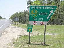
While the New Jersey Turnpike uses a system of long-distance tickets, obtained once by a motorist upon entering and surrendered upon exiting at toll gates (a "closed" system), the Garden State Parkway uses no tickets but collects tolls at toll plazas at somewhat regular intervals along its length and at certain exits (an "open" system). As of 2014, the standard car toll is $0.75 on the main road at two-way toll plazas and $1.50 at one-way toll plazas. Some individual exits require a toll of either $0.50, $0.75, or $1.50.
The parkway has implemented the E-ZPass electronic toll collection system; the first plaza opened in December 1999, and the was system completed on September 19, 2000.[31] Parkway tokens continued to be available until January 1, 2002,[32] and were invalidated effective January 1, 2009.[33] Drivers using exact change lanes are now required to pay with coins only in all toll baskets. The Union Toll Plaza was the first to use an automated toll-collection machine. A plaque commemorating this event includes the first quarter collected at its toll booths.[34]
Tokens originally cost $10 for a roll of 40 tokens (the toll was 25 cents when tokens were introduced), but when the toll was increased to 35 cents, rolls were 30 tokens for $10. Before invalidating the tokens, the NJHA gave several months' warning and gave motorists the opportunity to redeem tokens. Tokens were originally brass, but were changed to a bimetallic composition with an outer silver-colored ring and a brass core. There were also larger bus tokens that existed in each composition, primarily for the use of Atlantic City-bound buses. These were sold in rolls of 20 for $20.

To reduce congestion, some toll plazas on the roadway were converted into one-way plazas between September 2004 and February 2010, dubbed "one-way tolling".[35] Under this program, a $1.50 toll (70 cents or two tokens when first implemented from September 2004 to November 2008 and $1.00 was implemented from December 2008 to December 2011 which was the first phase of the toll increase) is collected in one direction, and the other direction is toll-free. The Cape May (in Upper Township), Great Egg (in Somers Point), New Gretna (in Bass River Township), Barnegat (in Barnegat Township), Asbury Park (in Tinton Falls), Raritan (in Sayreville), Union (in Hillside Township), Essex (in Bloomfield Township), Bergen (in Saddle Brook Township), and Pascack Valley (in Washington Township) toll plazas had been converted to one-way toll plazas. The Toms River (in Toms River Township) Toll Plaza is the only $0.75 toll barrier plaza that is collected in both directions.
Beginning on November 19, 2001, E-ZPass customers were charged the approximate token rate, that is 33 cents (peak travel) or 30 cents (off-peak travel), instead of 35 cents.[32] Due to tremendous cost overruns in implementing the E-ZPass system on New Jersey's toll highways the discount was eliminated the next year.[36] NJHA E-ZPass customers were charged a $1-per-month account fee,[36] causing many customers to turn in their NJHA E-ZPass transponders in favor of a transponder from an out-of-state authority which did not charge a monthly fee.

On January 8, 2008, New Jersey Governor Jon Corzine proposed increases of fifty percent in tolls on the parkway and turnpike effective in 2010, to be followed by similar 50 percent increases every four years through 2022. Each time tolls increased, there would be an additional increase for inflation since the last toll increase (for the first, since 2006). This increase in tolls, which would take place on all three of New Jersey's toll roads, would, according to Corzine, help pay the state's debt. The roads would be maintained by a nonprofit "public benefit corporation" which would pay back bonds to the state. Without considering inflation, the proposal would have increased the standard 35-cent toll on the Garden State Parkway to approximately $1.80 by 2022, with tolls for the entire length of the northbound Garden State Parkway rising from $4.55 to $30.10 in 2022.[37] It was considered possible that commuters will receive discounts from the higher toll rates.[38] The proposal was not enacted due to fierce opposition from the state of New Jersey. On September 5, 2008, a proposal to increase parkway tolls substantially was reported. The first phase of the toll increase on the Garden State Parkway went into effect on December 1, 2008. As of January 1, 2012, toll rates on the Garden State Parkway are $0.50 for ramp tolls, $0.75 for two-way toll barriers, and $1.50 for one-way toll barriers.[39][40]
There are three types of toll lanes at the toll plazas, however not all plazas have every type of lane at all times. The first are E-ZPass only, which only accept vehicles with E-ZPass tags. The speed limit in these lanes is 15 mph (24 km/h), or 55–65 mph (89–105 km/h) for Express E-ZPass lanes, depending on the parkway's actual speed limit.
The second type of lane is exact change. Although they previously accepted both parkway tokens or exact change, the tokens were no longer sold after January 1, 2002, and were no longer accepted on the parkway after January 1, 2009. Drivers using exact change lanes are now required to pay with coins only. In these lanes, motorists deposit coins in a toll basket and each coin is mechanically counted. Payment of tolls is enforced by photo, a system that went into effect on October 17, 2011.[41]
The third type of toll lane is cash receipts. These lanes are manned; toll collectors can provide change and receipts to drivers. E-ZPass is also accepted.
Picnic areas
One of the objectives of the parkway was to become a state park its entire length, and its users would enjoy park-like aesthetics with minimal intrusion of urban scenery. Along the ride, users were permitted to stop and picnic along the roadway to further enjoy the relaxation qualities the parkway had to offer. All picnic areas had tall trees that provided shade and visual isolation from the roadway. Grills, benches, running water and restrooms were provided. Over time as the parkway transformed into a road of commerce, the picnic areas were being closed for a variety of reasons. Their ramp terminals became insufficient to accommodate the high-speed mainline traffic and in addition to the decreasing amount of users, the picnic areas were becoming more effective as maintenance yards and were converted as such or closed altogether.
The history of the picnic areas includes an infamous story in the murder of Maria Marshall orchestrated by her husband Robert O. Marshall in the Oyster Creek picnic area on the night of September 7, 1984.[42] The story was made into a novel and television movie on NBC.
The three remaining picnic areas are closed from dusk to dawn. Posted signs within the picnic area prohibit fires and camping.
There were ten operational picnic areas:
- Tall Oaks (closed): southbound only formerly at milepost 137
- Madison Hill (closed): northbound only formerly at milepost 134.9
- Glenside (closed): southbound only formerly at milepost 130.2
- Telegraph Hill (open): exit 116
- Herbertsville (closed): southbound only; converted to a maintenance yard of the same name and heavy vehicle weigh station
- Polhemus Creek (closed): northbound only formerly at milepost 87.2
- Double Trouble (closed): southbound only formerly at milepost 79.0
- Oyster Creek: located in the median in Lacey Township. The facility is not signed from the mainline Parkway, but there are signs located within the picnic area that state the facility is closed from dusk to dawn and that fires and camping are prohibited similar to the signs posted at the other two picnic areas currently open. The official Garden State Parkway website does not list Oyster Creek as a picnic area. It is possible that this picnic area has for all intents and purposes closed since this section of the Parkway is currently experiencing a major widening construction project and access to it is blocked and most likely will not reopen since the land used for widening the mainline was taken from the picnic area.
- Stafford Forge (closed): located in the median at milepost 61.1
- John B. Townsend Shoemaker Holly (open): located in the median at milepost 22.7. John B. Townsend was a physician from Ocean City who became the New Jersey Highway Authority's second Vice Chairman in 1955. The word Shoemaker comes from the last name of the landowner in the way of the Parkway's alignment during its initial construction. The term Holly comes from the Shoemaker's holly tree that was on his property. The tree is presumed to be 300 years old and one of, if not, the oldest holly tree in the United States.[43]
Service areas
All service areas are located in the center median, unless otherwise noted.
- Montvale: food, restrooms, information, and fuel (milepost 171)
- Brookdale North: fuel only; right-side exit northbound
- Brookdale South: food, restrooms, and fuel (milepost 153.3): right-side exit southbound
- Vaux Hall: food, restrooms, and fuel (milepost 142): right-side exit northbound
- Colonia North: fuel, convenience store and restrooms only; right-side exit northbound
- Colonia South: fuel, convenience store and restrooms only; right-side exit southbound
- Cheesequake: food, restrooms, and fuel (milepost 123)
- Monmouth: food, restrooms, and fuel (formerly Manasquan, milepost 100.4)
- Forked River: food, restrooms, and fuel (milepost 76)
- Atlantic: food, restrooms, information, and fuel (formerly Atlantic City or Absecon, milepost 41.4)
- Ocean View (formerly Seaville, milepost 18.3): restrooms, vending machines and tourist information only 8am–5pm year-round; fuel 6am–10pm except from Memorial Day to Labor Day when 24 hours
The first service area to open was Cheesequake on May 1, 1955. Prior to that grand opening, the New Jersey Highway Authority had constructed and operated two temporary service areas that offered only gasoline and other vehicular essentials.
- New Gretna: located in the median at milepost 53 that has since been converted to a State Police substation.
- New Shrewsbury: located in the median at milepost 107.
Park-ettes
In the 1950s, four petroleum companies were hired to provide gasoline and vehicular necessities—Esso, Texaco, Atlantic and Cities Service. The Cities Service company was the petroleum provider at Monmouth, Forked River, Atlantic City (Absecon at the time) and Ocean View (Seaville at the time) and offered a service where female employees were hired for those service area showrooms, wore uniforms and were known as the Park-ettes. Their duties included providing directions and other information to motorists as well as rendering odd bits of service such as sewing a missing button on a patron's coat.[44]
Exit list
Many entrances and exits have tolls. In general, exits have tolls when they precede a barrier toll, and exits are free when they follow a barrier toll. Conversely, entrances that precede a barrier toll are free; and tolls are paid at entrances just beyond a barrier toll. This avoids double tolling (e.g., paying a barrier toll and then immediately paying again to exit) and under-tolling (e.g., driving a long distance and then exiting for free just before a barrier toll).
There are no tolls between exits 127 and 141, inclusive, as this was the original road segment that predates the New Jersey Highway Authority.
| County | Location | mi[1] | km | Exit | Destinations | Notes[45] |
|---|---|---|---|---|---|---|
| Cape May | Lower Township | 0.00 | 0.00 | 0 | At-grade intersection | |
| Middle Township | 3.90 | 6.28 | 4 | Toll (northbound exit and southbound entrance); signed as exit 4A (south) and 4B (north) southbound | ||
| 6.54 | 10.53 | 6 | Southbound exit and northbound entrance | |||
| 8.40 | 13.52 | 9 | Former at-grade intersection, removed 2014 | |||
| 9.90 | 15.93 | 10 | Cape May Court House, Stone Harbor | Access via CR 657, former at-grade intersection, removed 2014[22] | ||
| 11.04 | 17.77 | 11 | Former at-grade intersection, removed 2015[22] | |||
| 11.80 | 18.99 | 12 | Southbound entrance only, no exit | |||
| 13.60 | 21.89 | 13 | ||||
| Dennis Township | 17.50 | 28.16 | 17 | Sea Isle City, Dennis Township | Access via CR 625, southbound exit and northbound entrance | |
| Upper Township | 19.38 | 31.19 | Cape May Toll Plaza (northbound only) | |||
| 20.25 | 32.59 | 20 | Northbound exit and southbound entrance | |||
| 25.34 | 40.78 | 25 | Southern terminus of concurrency with US 9; access to Corson's Inlet State Park | |||
| Great Egg Harbor Bay | 27.77 | 44.69 | Great Egg Harbor Bridge | |||
| Atlantic | Somers Point | 28.78 | 46.32 | Great Egg Toll Plaza (southbound only) | ||
| 28.90 | 46.51 | 29 | Northern terminus of concurrency with US 9; northbound exit and southbound entrance | |||
| 30.00 | 48.28 | 30 | Somers Point, Ocean City | Access via North Laurel Drive, southbound exit and northbound entrance, toll on southbound exit | ||
| Egg Harbor Township | 35.82 | 57.65 | 36 | No southbound exit, northbound exit only | ||
| 36.08 | 58.07 | No northbound exit, southbound exit only | ||||
| 36.28 | 58.39 | 37N | Northbound entrance only, no exit | |||
| 36.59 | 58.89 | 37 | Southbound exit and northbound entrance, access to CR 563 north | |||
| 37.23 | 59.92 | 38 | Signed as exits 38 (east) and 38A (west), Exit 38A provides access to Atlantic City International Airport and the FAA Tech Center | |||
| Galloway Township | 40.04 | 64.44 | 40 | Southbound exit and northbound entrance | ||
| 41.70 | 67.11 | 41 | Opened March 13, 2015; Access to AtlantiCare Medical Campus and Stockton University | |||
| 43.98 | 70.78 | 44 | Northbound exit and southbound entrance opened August 2015; Access to Stockton University, Atlantic City International Airport and the FAA Tech Center | |||
| Port Republic | 48.29 | 77.72 | 48 | Southern terminus of concurrency with US 9; southbound exit and northbound entrance | ||
| Burlington | Bass River Township | 50.67 | 81.55 | 50 | Northern terminus of concurrency with US 9; northbound exit and southbound entrance | |
| 52.70 | 84.81 | 52 | Southbound exit and northbound entrance | |||
| 53.54 | 86.16 | New Gretna Toll Plaza (northbound only) | ||||
| Ocean | Little Egg Harbor Township | 58.69 | 94.45 | 58 | ||
| Stafford Township | 64.11 | 103.18 | 63 | Signed as exits 63A (east) and 63B (west) northbound | ||
| Barnegat Township | 67.81 | 109.13 | 67 | Signed as exits 67A (east) and 67B (west) southbound | ||
| 68.61 | 110.42 | Barnegat Toll Plaza (southbound only) | ||||
| Ocean Township | 70.45 | 113.38 | 69 | Toll (southbound exit and northbound entrance) | ||
| Lacey Township | 75.34 | 121.25 | 74 | Toll (southbound exit and northbound entrance) | ||
| Berkeley Township | 77.40 | 124.56 | 77 | Berkeley | Access via CR 618 / CR 619, toll (southbound exit and northbound entrance) | |
| South Toms River | 80.85 | 130.12 | 80 | Southern terminus of concurrency with US 9; southbound exit and northbound entrance | ||
| Toms River | 81.85 | 131.72 | 81 | Lakehurst Road (CR 527) – Toms River | ||
| 82.35 | 132.53 | 82 | Signed as exits 82 (east) and 82A (west); access to Island Beach State Park | |||
| 84.10 | 135.35 | 83 | Northern terminus of concurrency with US 9; no southbound exit | |||
| 84.72 | 136.34 | Toms River Toll Plaza | ||||
| Lakewood Township | 89.36 | 143.81 | 89 | Signed as exit 89A northbound for Route 70 east and west; 89A (east) and 89B (west) southbound; toll on all ramps | ||
| 90.18 | 145.13 | Signed as exit 89B northbound and 89C southbound; toll on all ramps | ||||
| Brick Township | 91.10 | 146.61 | 90 | Northbound exit and southbound entrance | ||
| 92.62 | 149.06 | 91 | Southbound exit and northbound entrance, signed as exits 91B (south) and 91A (north) southbound; toll on southbound exit and northbound entrance | |||
| Monmouth | Wall Township | 98.23 | 158.09 | 98 | Toll (southbound exit and northbound entrance) | |
| Tinton Falls | 101.24– 101.60 | 162.93– 163.51 | 100 | No direct access from Route 33 west to Parkway south or from Parkway south to Route 66 east | ||
| 103.15 | 166.00 | 102 | Neptune, Asbury Park | Access via CR 16, southbound exit and northbound entrance | ||
| 103.96 | 167.31 | Asbury Park Toll Plaza (northbound only) | ||||
| 104.20 | 167.69 | South end of local-express lanes split | ||||
| 106.12– 106.39 | 170.78– 171.22 | 105 | Toll (southbound exit and northbound entrance); southbound exit and northbound entrance from express lanes; commercial vehicles must exit here | |||
| Middletown Township | 110.14 | 177.25 | 109 | Toll (southbound exit and northbound entrance) | ||
| Middletown–Holmdel township line | 113.88 | 183.27 | 114 | Holmdel, Middletown | Access via CR 52, toll (southbound exit and northbound entrance) | |
| Holmdel Township | 115.85 | 186.44 | 116 | |||
| 117.00 | 188.29 | Crossover ramps between express and local lanes | ||||
| Hazlet Township | 118.50 | 190.71 | 117 | Toll (southbound exit and northbound entrance); southbound exit and northbound entrance from express lanes | ||
| Aberdeen Township | 118.79 | 191.17 | 118 | Aberdeen | Access via CR 3, southbound exit and entrance, toll, formerly 117A until 2016 | |
| Middlesex | Old Bridge Township | 121.13 | 194.94 | 120 | Laurence Harbor, Matawan | Access via CR 689, access to Cheesequake State Park |
| Sayreville | 124.64 | 200.59 | 123 | Southbound exit and northbound entrance | ||
| 124.99 | 201.15 | 124 | Main Street (CR 670) – Sayreville, South Amboy | Southbound exit and northbound entrance | ||
| 125.28 | 201.62 | North end of local-express lanes split | ||||
| 125.68 | 202.26 | Raritan Toll Plaza (southbound only) | ||||
| 126.36 | 203.36 | 125 | Northbound exit and southbound entrance | |||
| Raritan River | 127.33 | 204.92 | Driscoll Bridge | |||
| Woodbridge Township | 128.0 | 206.0 | 127 | Signed as exit 129 southbound; southbound exit via New Brunswick Avenue | ||
| 129.50 | 208.41 | 129 | Exit 11 on I-95 / Turnpike | |||
| 129.50 | 208.41 | Southbound exit only, northbound exit via exit 127 | ||||
| 130.63 | 210.23 | 130 | Southbound exit and northbound entrance; signed as exit 130B (south/Trenton) and 130A (north/Newark) | |||
| 131.33 | 211.36 | 131A | Wood Avenue South (CR 649) | Signed as exit 131 southbound | ||
| 131.83 | 212.16 | 131B | Access via CR 657, northbound exit and southbound entrance | |||
| 131.97 | 212.39 | 132 | Formerly exit 131 until March 2015[46] | |||
| Union | Clark | 136.22 | 219.22 | 135 | Clark, Westfield | Access via CR 613 |
| Cranford | 137.59 | 221.43 | 136 | Linden, Roselle, Winfield Park | Access via CR 607 / CR 615 | |
| 138.74 | 223.28 | 137 | ||||
| Kenilworth | 140.34 | 225.86 | 138 | |||
| Union Township | 141.10 | 227.08 | 139A | Chestnut Street (CR 619) | Northbound exit and entrance | |
| 139B | Signed as exit 140A (formally 140) southbound | |||||
| 141.70 | 228.04 | 140 | Signed as exit 140B (formally 140A) southbound | |||
| 142.10 | 228.69 | 141 | Vauxhall Road (CR 630) – Union | Southbound exit and northbound entrance | ||
| Hillside | 142.66 | 229.59 | Union Toll Plaza (northbound only) | |||
| 142.80 | 229.81 | 142A | Toll (northbound exit and entrance); southbound exit to I-78 east opened December 10, 2010 | |||
| 142.90 | 229.98 | 142B | Toll (northbound exit and entrance); northbound exit ramp to I-78 west opened September 16, 2009 | |||
| 143.00 | 230.14 | 142C | Hillside, Maplewood | Access via North Union Avenue, northbound exit and southbound entrance | ||
| Essex | Irvington | 144.0 | 231.7 | 143 | Springfield Avenue (CR 603) / Lyons Avenue (CR 602) – Irvington, Maplewood, Hillside | Signed as exits 143A (Maplewood), 143B (Hillside) and 143C (Springfield) southbound |
| 145.98 | 234.93 | 144 | Toll (northbound exit and southbound entrance) | |||
| East Orange | 146.93– 147.15 | 236.46– 236.81 | 145 | Toll (northbound exit and southbound entrance) | ||
| 148.44 | 238.89 | 147 | Springdale Avenue – East Orange | Southbound exit and northbound entrance | ||
| Bloomfield | 149.2 | 240.1 | 148 | Toll (northbound exit and southbound entrance) | ||
| 150.22 | 241.76 | 149 | Belleville Avenue (CR 506) – Belleville, Glen Ridge | Southbound exit and northbound entrance | ||
| 150.66 | 242.46 | Essex Toll Plaza (southbound only) | ||||
| 151.1 | 243.2 | 150 | Hoover Avenue (CR 651) – Bloomfield, Belleville | Northbound exit and southbound entrance | ||
| 152.45 | 245.34 | 151 | Watchung Avenue (CR 655) – Nutley, Montclair | Toll (southbound exit and northbound entrance) | ||
| Passaic | Clifton | 154.06– 154.45 | 247.94– 248.56 | 153 | Toll (southbound exit and northbound entrance); signed as exits 153A (east) and 153B (west) northbound; no southbound access to Route 3 west, access to Meadowlands Sports Complex | |
| 155.91 | 250.91 | 154 | Toll (southbound exit and northbound entrance) | |||
| 156.4 | 251.7 | 155A | Northbound exit and southbound entrance, formerly exit 155P until 2016 | |||
| 156.68 | 252.15 | 155B | Hazel Street (CR 702) | Northbound exit and southbound entrance, formerly exit 155 until 2016 | ||
| 158.19 | 254.58 | 156 | Northbound exit and southbound entrance | |||
| Bergen | Elmwood Park | 158.87 | 255.68 | 157 | Same directional movements only | |
| Saddle Brook | 160– 160.35 | 260– 258.06 | 159 | Toll (on northbound exit); no direct northbound access to I-80 west | ||
| 160.46 | 258.24 | Bergen Toll Plaza (northbound only) | ||||
| Paramus | 161.53 | 259.96 | 160 | Northbound exit and southbound entrance | ||
| 161.88 | 260.52 | 161 | Northbound exit and southbound entrance | |||
| 163.06 | 262.42 | 163 | Southbound exit and northbound entrance, access to Meadowlands Sports Complex | |||
| 163.29 | 262.79 | Northbound exit and southbound entrance | ||||
| 164.94 | 265.45 | 165 | Ridgewood, Oradell | Access via CR 80, toll (northbound exit and southbound entrance) | ||
| 165.93 | 267.04 | 166 | Washington, Westwood | Access via CR 110, southbound exit and northbound entrance | ||
| Washington Township | 166.25 | 267.55 | Pascack Valley Toll Plaza (southbound only) | |||
| 167.46 | 269.50 | 168 | Northbound exit and southbound entrance | |||
| Woodcliff Lake | 170.15 | 273.83 | 171 | Chestnut Ridge Road (CR S-73) – Woodcliff Lake | Northbound exit and southbound entrance | |
| Montvale | 171.52 | 276.03 | 172 | Grand Avenue (CR 94) – Montvale, Park Ridge | Northbound exit and southbound entrance | |
| 172.40 | 277.45 | – | Continuation into New York via the GSP Connector | |||
1.000 mi = 1.609 km; 1.000 km = 0.621 mi
| ||||||
See also
 U.S. Roads portal
 New Jersey portal
References
- 1 2 3 4 5 6 7 8 9 10 11 12 13 14 15 16 17 18 19 "Garden State Parkway straight line diagram" (PDF). New Jersey Department of Transportation. Retrieved December 8, 2009.
- 1 2 "Title 16: Department of Transportation; Chapter 32: Truck Access" (PDF). New Jersey Department of Transportation. Retrieved August 13, 2010.
- ↑ Samuel, Peter (January 6, 2003). "15-lane bridge for Garden State Parkway". Tollroads News. Retrieved September 23, 2008. "The Garden State Parkway is America's busiest single tollroad in terms of toll transaction numbers - 609m in 2001 or 1.67m/day average."
- ↑ Samuel, Peter (January 29, 2008). "USA Today reports dramatically more expensive tolls—lousy data". TollRoadsNews. Retrieved September 23, 2008.
- 1 2 Laurie, Maxine N.; Mappen, Marc (2004–2005). Encyclopedia of New Jersey. Rutgers University Press. p. 305.
- ↑ Pierson, Melissa Holbrook (1998). The perfect vehicle: what it is about motorcycles. W. W. Norton & Company. p. 82. ISBN 0-393-31809-5.
- ↑ "Governor McGreevey Announces Planned Improvements from Turnpike Authority Consolidation" (Press release). New Jersey Turnpike Authority. July 10, 2003. Retrieved March 18, 2010.
- ↑ "New Jersey Sues Florida Pizza Shop". Philadelphia, PA: WCAU-TV. Associated Press. July 24, 2014. Retrieved July 24, 2014.
- ↑ Photo of Exit 171
- ↑ Travel Center Opens on Parkway
- ↑ Garden State Parkway Interchange 89
- ↑ Garden State Parkway Interchange 69
- ↑ Garden State Parkway Interchange 100
- ↑ Higgs, Larry (March 13, 2015). "What exit? Parkway exit numbers officially change today as new exit opens". NJ star Ledger. Retrieved March 13, 2015.
- ↑ Barnegat's interchange to open Wednesday May 20, 2009
- 1 2 "NJDOT's 2007–2010 Road Improvements" (PDF). (1.53 MB)
- ↑ Driscoll Bridge opening May 20, 2009
- 1 2 3 4 NJTPA Online Transportation Information System -- Project Detail
- ↑ "NJDOT to begin reconstruction of Route I-280/Garden State Parkway Interchange 145" (Press release). New Jersey Department of Transportation. September 15, 2006. Retrieved June 14, 2007.
- ↑ Pascack Valley One Way Toll
- ↑ "New ramp linking I-78 and the Garden State Parkway opens today". New Jersey Department of Transportation. December 10, 2010. Retrieved December 14, 2010.
- 1 2 3 "Advisory: Mechanic Street Exit from Garden State Parkway to Close Permanently". Middle Township New Jersey. Middle Township Municipality. Retrieved August 24, 2014.
- ↑ "NJDOT's 2005–2007 Road Improvements" (PDF). (80.9 KB) accessed June 18, 2007
- ↑ Nee, Daniel (July 13, 2016). "Parkway Exit 91 Project Now Shut Down, Brick Officials in the Dark". Brick Shorebeat. Retrieved September 3, 2016.
- ↑ "Garden State Parkway construction project focuses on new exits". Retrieved July 23, 2015.
- ↑ Google (September 16, 2016). "Google Street View imagery of Garden State Parkway" (Map). Google Maps. Google. Retrieved September 16, 2016.
- ↑ The NJ Law Reads as follows: "3. With the exception of vehicles holding a special permit, only New Jersey State Police vehicles, Authority maintenance vehicles and other Authority authorized vehicles, with a gross weight, G.V.W.R. and/or G.C.W.R. in excess of 10,000 pounds, shall be allowed on the Parkway north of Interchange 105, except that all vehicles in excess of 10,000 pounds are allowed on Ramp 7 in Woodbridge Township, Middlesex County for purposes of accessing the Turnpike."
- ↑ "Section 19:8-1.9(b)15" (PDF). Garden State Parkway Regulations. State of New Jersey. October 23, 1987. Retrieved October 17, 2007.
19:8-1.9(b)15: All vehicles except cars, campers, omnibuses, and vehicles entitled to toll-free passage under N.J.A.C. 19:8-3.2 (Toll-free passage) are prohibited from the Parkway north of Interchange 105.
- ↑ "N.J. to consider allowing trucks on Garden State Parkway north of exit 105". The Star-Ledger. Associated Press. April 18, 2011. Retrieved April 19, 2011.
- ↑ "N.J. won't allow trucks on Garden State Parkway north of exit 105". The Star-Ledger. Associated Press. April 18, 2011. Retrieved April 19, 2011.
- ↑ "E-ZPass open from N.Y. State to Cape May" (Press release). New Jersey Highway Authority. September 19, 2000.
- 1 2 "Parkway to Discontinue Token Sales" (Press release). New Jersey Highway Authority. December 26, 2001.
- ↑ Strauss, Robert (July 20, 2008). "Soon, Token Non Grata on the Garden State". The New York Times. Retrieved March 18, 2010.
- ↑ "Union Watersphere". lostinjersey.wordpress.com. March 19, 2009. Retrieved February 23, 2012.
- ↑ NJ Turnpike and Garden State Parkway Project. Retrieved May 11, 2011.
- 1 2 "E-ZPass: A plan that works for NJ" (PDF). July 11, 2002. pp. 9–10. Retrieved June 22, 2009.
- ↑ McCoy, Craig R. (January 9, 2008). "Corzine calls for 50% toll increase". The Philadelphia Inquirer.
- ↑ Nussbaum, Paul (January 11, 2008). "Corzine: Toll-hike breaks are likely". The Philadelphia Inquirer.
- ↑ Samuel, Peter (September 5, 2008). "Threatened by debt default New Jersey Turnpike proposes big toll increases". Tollroads News. Retrieved September 8, 2008.
- ↑ Toll increase in effect on January 1, 2012 on the NJ Turnpike and the Garden State Parkway Retrieved December 17, 2011.
- ↑ PAY TOLL Photo Enforced to all exact change lanes Retrieved October 13, 2011.
- ↑ Sheppard, R.Z. (January 2, 1989). "Books: Serpents in The Garden State". Time. Retrieved May 3, 2010.
- ↑ Cape May County Points of Interest
- ↑ "The First Five Years of the Garden State Parkway" published by the New Jersey Highway Authority, page 29.
- ↑ Garden State Parkway Exits & Toll Barriers
- ↑ "What Exit? New Jersey Question Gets a Bit Trickier". Philadelphia, PA: WCAU-TV. March 13, 2015. Retrieved November 4, 2015.
External links
| Wikimedia Commons has media related to Garden State Parkway. |
- New Jersey Turnpike Authority & Garden State Parkway Official Website
- History of the Garden State Parkway
- "NJ Route 444" (PDF). (2.82 MB) Straight Line Diagram
- Photos of the Garden State Parkway
- New Jersey Expressways and Tollways
- Garden State Parkway (NJ 444) (Greater New York Roads)