Interstate 95 in New Jersey
.svg.png)
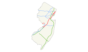
Interstate 95 (I-95) is a major Interstate Highway that traverses nearly the full extent of the East Coast of the United States, from Florida to Maine, with the exception of a small gap in New Jersey. In New Jersey, it runs along much of the main line of the New Jersey Turnpike, as well as the Pearl Harbor Memorial Extension (formerly and still commonly known as the Pennsylvania Turnpike Connector) and the New Jersey Turnpike's northern continuation to the George Washington Bridge, also maintained by the New Jersey Turnpike Authority, for a total of 77.96 mi (125.46 km). Located in the northeastern part of the state near New York City, the 11.03-mile (17.75 km) Western Spur of the New Jersey Turnpike, considered to be Route 95W by the New Jersey Department of Transportation, is also part of I-95. There is also a segment of I-95 to the north of Trenton that is 8.77 mi (14.11 km) and connects the Scudder Falls Bridge to I-295 and U.S. Route 1 (US 1); this is officially Route 95M.
As implied by the two segments listed above, I-95 is discontinuous within New Jersey. From the Pennsylvania direction, I-95 enters New Jersey on the Scudder Falls Bridge and halts at the US 1 interchange, where the freeway turns south as I-295. From the New York direction, I-95 enters New Jersey from the George Washington Bridge and continues south on the New Jersey Turnpike and Pearl Harbor Memorial Extension, where it becomes I-276 at the Delaware River-Turnpike Toll Bridge into Pennsylvania. This discontinuation was caused by the cancellation of the Somerset Freeway in 1983, which would have run from the Trenton segment of I-95 in Hopewell Township northeast to I-287 in Piscataway Township. Here, I-95 would follow present-day I-287 to the New Jersey Turnpike in Edison. In order to fill the gap, the Pennsylvania Turnpike/Interstate 95 Interchange Project has started construction of an interchange between the Pennsylvania Turnpike and I-95 in Bristol Township, Pennsylvania, with I-95 being rerouted to use the Pennsylvania Turnpike to the Delaware River-Turnpike Toll Bridge. The current I-95 around the north side of Trenton to the new interchange will become an extension of I-295, having originally been planned as an extension of I-195 between 2005 and 2015. This interchange is expected to open in 2018, allowing a most direct freeway route from New York City to downtown Philadelphia.
Route description
Trenton segment
_in_Ewing%2C_New_Jersey.JPG)
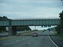
The New Jersey segment of I-95 north of Trenton, officially numbered as Route 95M by the New Jersey Department of Transportation, begins at the Scudder Falls Bridge over the Delaware River in Ewing Township, Mercer County. This bridge is four-lanes wide and is maintained by the Delaware River Joint Toll Bridge Commission.[1] From this point, I-95 continues south into Bucks County, Pennsylvania towards Philadelphia.[4] Immediately after the river, the freeway comes to the Route 29 interchange that also has a northbound entrance from Route 175.[1] Past this interchange, I-95 becomes maintained by the New Jersey Department of Transportation and widens to six lanes, heading northeast past suburban development containing some farmland. The next interchange along the route provides access to CR 579 and the Trenton-Mercer Airport. After CR 579, the highway passes to the northwest of the airport before coming into Hopewell Township. A cloverleaf interchange with CR 611 also serves the Trenton-Mercer Airport.[1][4] I-95 turns east, passing through Ewing Township again before coming back into Hopewell Township and reaching the Route 31 interchange.[1]
The median of the freeway widens as it runs near suburban residential areas and comes into Lawrence Township. This is where the Somerset Freeway would have begun had it been built. Upon entering Lawrence Township, the median narrows and I-95 has a southbound exit and northbound entrance serving Federal City Road.[1][4] Continuing east, the road reaches a cloverleaf interchange with US 206. After US 206, I-95 comes to a northbound ramp to CR 546 before coming to a partial cloverleaf interchange at CR 583.[1] From this point, the freeway passes commercial areas before reaching a cloverleaf interchange at US 1. This segment of I-95 ends just west of the US 1 interchange and the freeway turns south as I-295, where motorists use I-295 south and I-195 east to access the New Jersey Turnpike and the main segment of I-95 in New Jersey.[1][4][5]
Main segment
New Jersey Turnpike
The main segment of I-95 in New Jersey officially begins at the Delaware River-Turnpike Toll Bridge over the Delaware River in Burlington Township, Burlington County, where the road continues west into Pennsylvania as the Pennsylvania Turnpike (I-276).[2][6] From the river, I-95 follows the six-lane Pearl Harbor Memorial Extension of the New Jersey Turnpike east into New Jersey. This road, which is maintained by the New Jersey Turnpike Authority, is not signed as part of I-95 but rather as the New Jersey Turnpike or as I-276 from the mainline New Jersey Turnpike.[7][8] Continuing east through rural areas into Florence Township, the highway has an interchange serving US 130.[2][9] This interchange has a toll plaza on the ramp to southbound I-95. After this interchange, the road comes to a toll barrier that marks the beginning of the turnpike ticket system northbound and the end of the ticket system southbound.[9][10] The Pearl Harbor Memorial Extension crosses into Mansfield Township and passes under I-295 before merging into the mainline of the New Jersey Turnpike at exit 6.[2]
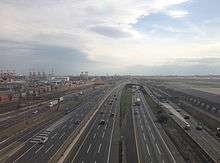
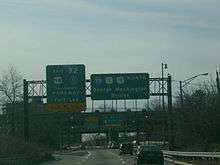
At this point, I-95, still not signed, continues northeast on the mainline of the New Jersey Turnpike, with twelve lanes featuring six inner lanes exclusively for cars separated from six outer lanes for cars, trucks and buses.[2][11] It soon reaches an exit for US 206 in Bordentown Township. Continuing north through mostly rural areas, the road heads into Mercer County and comes to the I-195 interchange in Robbinsville Township. At I-195, the New Jersey Turnpike becomes signed as part of I-95.[12] In East Windsor Township, the road comes to the exit for Route 133/Route 33, located to the east of Hightstown.[2][9] Heading into Middlesex County, development near the highway increases.[9][13] At this point, an interchange serves Route 32 in Monroe Township.[2] Continuing north into more dense suburban development, I-95 intersects Route 18 in East Brunswick Township near the city of New Brunswick.[2][9] After crossing the Raritan River, the New Jersey Turnpike heads northeast to the I-287/Route 440 junction in Edison. In Woodbridge Township, the highway comes to a large interchange accessing both the Garden State Parkway and US 9.[2] From this point, the road enters areas of heavy industry and comes to the CR 602 exit in Carteret. In Union County, I-95 comes to the I-278 exit on the border of Linden and Elizabeth at the western approach to the Goethals Bridge. In the northern part of Elizabeth, the New Jersey Turnpike comes to Route 81 which provides access to the Newark Liberty International Airport before the road runs to the east of the airport. After the airport, I-95 intersects I-78 in Newark, Essex County.[2][9] At US 1-9 Truck, the New Jersey Turnpike splits into two alignments and enters the New Jersey Meadowlands.[2][6][9]
The mainline of I-95 officially follows the Eastern Spur of the New Jersey Turnpike, which has exits to I-280 in Kearny, Hudson County and the Secaucus Junction train station and Route 3/Route 495 in Secaucus, where it reaches the end of the ticket system.[2][10] The Western Spur of the New Jersey Turnpike is signed as I-95 also but officially known as Route 95W.[3] This road has interchanges serving I-280 in Kearny and Route 3/Route 120 in East Rutherford, Bergen County, the latter serving the Meadowlands Sports Complex.[3][9] The ticket system on the Western Spur ends at a barrier in Carlstadt.[3][10] In Ridgefield, the two segments of the New Jersey Turnpike merge again, with the road continuing north into Ridgefield Park.[2][6]
George Washington Bridge approach
In Ridgefield Park, I-95 continues north as a toll-free highway co-signed with the New Jersey Turnpike and maintained by the New Jersey Turnpike Authority.[2][14] It has a large interchange serving US 46, part of which was the original northern terminus of the turnpike.[2] From this point, it has the appearance of a local-express lane configuration carrying three local lanes and two express lanes (3-2-2-3) in each direction, but the northbound "express" lane only leads to I-80 west while the northbound local lanes continues as the main trunk of I-95. The road runs near suburban neighborhoods before entering Teaneck and intersecting with the eastern terminus of I-80. From here, I-95 turns northeast and splits into an actual local-express lane configuration with a 3-2-2-3 lane count, soon interchanging with CR 56 as it passes northwest of Overpeck County Park. The highway turns east as it skirts the border between Englewood to the north and Leonia to the south, entering inhabited areas as it has a northbound exit and southbound entrance serving Broad Avenue.[2][9] I-95 makes a turn to the southeast into Fort Lee, and heads due south to Route 4. At this point, I-95 runs in between the travel lanes of Route 4 as the freeway comes to a large interchange with southbound exits and northbound entrances for Route 4, US 1-9, US 46, and a full interchange with the southern terminus of US 9W (where the Turnpike officially ends and the jurisdiction changes from the Turnpike Authority to the Port Authority).[2]
Here, US 1-9 / US 46 all join I-95 and the road continues southeast containing four local lanes and four express lanes in each direction, passing numerous high-rise buildings.[2][9] The road has a southbound exit and northbound entrance to Route 67 from the express lanes before coming to the eastbound-only toll plaza for the George Washington Bridge. Past the toll plaza, there is a southbound exit and northbound entrance for the Palisades Interstate Parkway, also from the express lanes. After the Palisades Interstate Parkway, the road crosses the Hudson River on the George Washington Bridge, which has eight lanes total on the upper deck (the express lanes) and six lanes total on the lower deck (the local lanes).[2]
History
What is now I-95 and I-295 around the northern part of Trenton was first legislated as part of Route 39, a route that was to run from the Yardley-Wilburtha Bridge around Trenton and then south to Hammonton.[15][16] Seven northeastern states from Virginia to Massachusetts including New Jersey proposed a limited-access highway in 1942 called the 7-State Highway; this was never built.[17] The New Jersey State Highway Department proposed Federal Aid Interstate Route 103 in 1956, and it was approved in 1957 by the Bureau of Public Roads (BPR).[18] At that time, the New Jersey Turnpike (main line and Pennsylvania Extension) and George Washington Bridge had been completed; US 46 connected the north end of the New Jersey Turnpike to the bridge.[19][20][21] The BPR approved the planned alignment north of the Trenton area, which would have run generally northeast to exit 9 (Route 18) of the New Jersey Turnpike. From there it would use the New Jersey Turnpike to its north end (exit 18, US 46) and a proposed freeway north to the planned I-80, then head east to the George Washington Bridge. The road was designated as part of I-95 in 1958.[18]
In the 1960s, the I-95 approach to the George Washington Bridge was completed, connecting to I-80 in Teaneck.[22] The portion of I-95 between the north end of the New Jersey Turnpike and I-80 opened in 1971.[23]
Routing through Central New Jersey: Somerset Freeway
The location of I-95 in the Trenton area had not been finalized when the route was first designated. The BPR preferred using the Trenton Freeway (US 1 and Route 174), which was completed to Whitehead Road, but New Jersey and Pennsylvania proposed using the Scudder Falls Bridge and its approach (Route 129), opened in 1961 to Scotch Road (exit 3), due in part to low design standards of the Trenton Freeway. As a result, I-95 was routed to use the Scudder Falls Bridge approach.[22][24] The approach to the Scudder Falls Bridge was extended in 1974, northeast to the planned interchange with the new I-95 freeway, and then east to US 1 as I-295.[24]
From the I-95/I-295 loop around Trenton, the free routing of I-95 in New Jersey, was to divert from the loop between the Route 31 and Federal City Road exits in Hopewell Township. Then, the highway was to intersect CR 546 and US 206 before coming to I-287 in Piscataway Township.[22] There was also meant to be a small connector roughly one mile in length connecting I-95 with I-287 from the north and designated I-695.[25] (The I-695 designation, along with I-95's alignment in Piscataway Township, was dropped when I-695's own alignment became the preferred routing for I-95 to a full 3-way interchange with I-287 in Franklin Township.[26][27])
At this point, the freeway would have continued northeastward through the western parts of Elizabeth and Newark, then terminate at the northern terminus of the New Jersey Turnpike at Ridgefield, but it was instead decided to route I-95 along the New Jersey Turnpike through North Jersey.[22][28]
The truncated route, known as the Somerset Freeway, was intended to terminate in Piscataway Township at I-287, and I-95 would have continued east along I-287 until it intersected with the New Jersey Turnpike in Edison Township.[22] Both the Somerset Freeway and I-695 were projected to cost $55 million in 1967, with the cost increasing to $375 million in 1979.[25][29] At this point, residents in Hopewell Township, Princeton, and Montgomery Township raised opposition out of the fear the Somerset Freeway would bring unwanted development to area farmland. The New Jersey Turnpike Authority joined environmental and community groups in opposing the Somerset Freeway, as it would provide a toll-free alternative to the New Jersey Turnpike.[30][31] Due to this opposition, New Jersey Governor Brendan Byrne announced in 1980 that the state would not build the Somerset Freeway.[32] The United States Senate officially cancelled the Somerset Freeway in 1983. As a result of this cancellation, the federal government gave New Jersey $246 million for road projects in the area where the Somerset Freeway was to be built.[31]
The New Jersey Department of Transportation transferred the section of I-95 between the north end of the New Jersey Turnpike and the George Washington Bridge to the New Jersey Turnpike Authority in 1992 in order to balance the state budget, thus incorporating it as part of the mainline Turnpike.[14][33]
In 1995, increasing truck traffic on US 206 and Route 31 motivated officials in Mercer County to have the state reconsider building the Somerset Freeway as a way to alleviate traffic on area roads. This option was ruled out due to a $700 million price tag.[34] Also around this time, I-95 was extended east along I-295 between the site of the Somerset Freeway interchange and US 1 in Lawrence Township. Also, the road was officially extended down the New Jersey Turnpike and Pennsylvania Extension to the Delaware River-Turnpike Toll Bridge.[35]
Filling the I-95 gap
Due to the cancellation of the Somerset Freeway, a gap exists on I-95 within New Jersey.[17] I-95 enters New Jersey from Pennsylvania on the Scudder Falls Bridge and heads east to an interchange with US 1 (Brunswick Pike) in Lawrence Township. The road becomes I-295 southbound as it passes through the interchange.[1] Meanwhile, I-95 enters New Jersey from New York on the George Washington Bridge and heads south on the New Jersey Turnpike and Pennsylvania Extension to the Delaware River-Turnpike Toll Bridge, becoming I-276 at the state line.[2] Traffic must utilize other roads in order to fill the gap. For traffic running north–south along the Atlantic seaboard bypassing Philadelphia, the discontinuous sections are linked by the remainder of the New Jersey Turnpike (and I-295 over the Delaware Memorial Bridge).[36] Southbound I-95 traffic headed to Delaware is directed to continue south on the New Jersey Turnpike and use the Delaware Memorial Bridge.[37] The same is done in reverse: thru traffic on I-95 near Wilmington, Delaware is pointed to New Jersey and New York City via the Delaware Memorial Bridge and the New Jersey Turnpike.[38] Meanwhile, traffic from Pennsylvania and Trenton is directed via I-295 and I-195.[5]
In order to close this gap in I-95, an interchange is planned between I-95 and the Pennsylvania Turnpike in Bristol Township, Pennsylvania. The interchange was first planned in the 1980s after the Somerset Freeway was cancelled, making I-95 discontinuous.[39] As a result of this project, I-95 will be rerouted from its current alignment in Pennsylvania at the interchange to the easternmost part of the Pennsylvania Turnpike, replacing I-276 between the interchange and the Delaware River at the Delaware River-Turnpike Toll Bridge. In addition, I-295 will be extended westward from its current northern terminus and around the north side of Trenton on present-day I-95 to the new interchange. I-295 was initially chosen to be extended to the new interchange, but in 2005 plans were changed to extend I-195 from its current western terminus at I-295 and bypass Trenton to the north along I-295 and I-95 to head to the new interchange.[40] On May 20, 2015, the plans were reverted to extend I-295 to the interchange.[41] The multi-phased construction began in late 2010, and the approved design calls for Phase I to tentatively end some time between 2017[5] and 2018.[42] Groundbreaking for the interchange took place on July 30, 2013, with Governor Tom Corbett in attendance.[43]
Exit list
Trenton segment
| County | Location | mi[1] | km | Exit | Destinations | Notes |
|---|---|---|---|---|---|---|
| Bucks | Lower Makefield Township | 0.00 | 0.00 | Pennsylvania state line | ||
| Delaware River | 0.00 | 0.00 | Scudder Falls Bridge | |||
| Mercer | Ewing Township | 0.07 | 0.11 | 1 | ||
| 1.56 | 2.51 | 2 | ||||
| Hopewell Township | 2.83 | 4.55 | 3 | Scotch Road (CR 611) – Trenton-Mercer Airport General Aviation | Split into exits 3A and 3B northbound | |
| 4.24 | 6.82 | 4 | ||||
| Lawrence Township | 5.64 | 9.08 | 5 | Federal City Road | Southbound exit and northbound entrance; split into exits 5A and 5B | |
| 7.11 | 11.44 | 7 | Split into exits 7A and 7B | |||
| 8.12 | 13.07 | 8 | Split into exits 8A and 8B; northbound exit 8A is CR 546 east to CR 583 south | |||
| 8.77 | 14.11 | 67 | Split into exits 67A and 67B northbound. | |||
| Northern terminus of Trenton segment of I-95. Northern terminus of I-295. | ||||||
| 1.000 mi = 1.609 km; 1.000 km = 0.621 mi | ||||||
Main segment
| County | Location | mi[2][3] | km | Exit | Destinations | Notes |
|---|---|---|---|---|---|---|
| Bucks | Bristol Township | 0.00 | 0.00 | Southern terminus of I-95 in New Jersey; Pennsylvania state line | ||
| Delaware River | 0.00 | 0.00 | Delaware River-Turnpike Toll Bridge | |||
| Burlington | Florence Township | 2.61 | 4.20 | 6A | Exit number unsigned; toll plaza at southbound entrance | |
| 3.17 | 5.10 | NJ Turnpike Exit 6 Toll Plaza (Pennsylvania Turnpike) | ||||
| Mansfield Township | 5.33– 6.50 | 8.58– 10.46 | 6 | South end of overlap with NJ Turnpike mainline | ||
| 6.50 | 10.46 | Southern end of dual-dual set up; inner roadway for cars only and outer roadway for cars-trucks-buses | ||||
| Bordentown Township | 7.95 | 12.79 | 7 | |||
| Mercer | Robbinsville Township | 15.15 | 24.38 | 7A | ||
| East Windsor Township | 22.12 | 35.60 | 8 | |||
| Middlesex | Monroe Township | 28.51 | 45.88 | 8A | ||
| East Brunswick Township | 38.07 | 61.27 | 9 | |||
| Raritan River | 38.89 | 62.59 | Basilone Bridge | |||
| Edison Township | 42.73 | 68.77 | 10 | |||
| Woodbridge Township | 45.65 | 73.47 | 11 | |||
| Carteret | 50.53 | 81.32 | 12 | Carteret, Rahway (CR 602) | ||
| Union | Elizabeth | 53.75 | 86.50 | 13 | I-278 exit 2 | |
| 56.33 | 90.65 | 13A | Elizabeth, Newark Airport, Elizabeth Seaport (Route 81 north) | |||
| Essex | Newark | 59.19 | 95.26 | 14 | Western terminus of the Newark Bay Extension | |
| 61.10– 61.30 | 98.33– 98.65 | Car and truck lanes end northbound and begin southbound. Eastern and Western Spurs (continuations of the car and truck lanes, respectively) begin northbound and end southbound. | ||||
| 61.52– 1.15 | 99.01– 1.85 | 15E | Full interchange on the Eastern Spur, southbound exit and northbound entrance on the Western Spur | |||
| Hudson | Kearny | 63.18– 3.08 | 101.68– 4.96 | 15W | Full interchange on the Western Spur, southbound exit and northbound entrance on the Eastern Spur | |
| Secaucus | 65.30 | 105.09 | 15X | Secaucus, Secaucus Junction Park-Ride | Exit on the Eastern Spur | |
| 67.23 | 108.20 | NJ Turnpike Exit 16E/18E Toll Plaza (Lincoln Tunnel/George Washington Bridge) | ||||
| 67.60 | 108.79 | 17 | Exit on the Eastern Spur; signed as exit 16E northbound; northbound entrance is toll-free | |||
| Bergen | East Rutherford | 7.02 | 11.30 | 16W | Exit on the Western Spur | |
| Carlstadt | 8.00– 8.10 | 12.87– 13.04 | NJ Turnpike exit 18W toll plaza (George Washington Bridge) | |||
| Ridgefield Park | 71.32– 11.03 | 114.78– 17.75 | Eastern and Western Spurs merge northbound and split southbound | |||
| 72.31 | 116.37 | 68 | Exit number only signed southbound, which also includes Teaneck Road | |||
| 72.48 | 116.65 | 68 | Challenger Road | Northbound exit only; southbound exit is part of exit 68 (US 46/Teaneck Road) | ||
| Express (upper) lanes and local (lower) lanes split northbound and merge southbound. | ||||||
| Teaneck Township | 73.59 | 118.43 | 69 | Exit number only signed southbound; east end of I-80, exits 68A-B | ||
| 74.10 | 119.25 | 70 | Leonia, Teaneck (CR 56) | Signed as exits 70A (Leonia) and 70B (Teaneck) northbound | ||
| Englewood | 75.58 | 121.63 | 71 | Broad Avenue – Leonia, Englewood | Northbound exit and southbound entrance | |
| Fort Lee | 76.2– 76.53 | 122.6– 123.16 | 72A | East end of Route 4; southbound exit and northbound entrance | ||
| 76.62– 76.66 | 123.31– 123.37 | 72B | South end of US 1-9 / US 46 overlap; southbound exit and northbound entrance | |||
| 77.02 | 123.95 | 72 | Signed as exit 73-74 southbound, north end of NJ Turnpike | |||
| 77.18 | 124.21 | 73 | Southbound exit and northbound entrance | |||
| 77.53 | 124.77 | 74 | Southbound exit and northbound entrance (upper level only) | |||
| Hudson River | 77.96 | 125.46 | George Washington Bridge | |||
| Northern terminus of I-95 in New Jersey; New York state line | ||||||
1.000 mi = 1.609 km; 1.000 km = 0.621 mi
| ||||||
See also
 U.S. Roads portal
 New Jersey portal
References
- 1 2 3 4 5 6 7 8 9 10 11 New Jersey Department of Transportation. "Interstate 95M straight line diagram" (PDF). Trenton: New Jersey Department of Transportation. Retrieved March 26, 2007.
- 1 2 3 4 5 6 7 8 9 10 11 12 13 14 15 16 17 18 19 20 21 22 New Jersey Department of Transportation. "Interstate 95 straight line diagram" (PDF). Trenton: New Jersey Department of Transportation. Retrieved March 26, 2007.
- 1 2 3 4 5 6 New Jersey Department of Transportation. "Interstate 95W straight line diagram" (PDF). Trenton: New Jersey Department of Transportation. Retrieved January 26, 2010.
- 1 2 3 4 Google (January 26, 2010). "Overview Map of I-95 in New Jersey (Trenton Section)" (Map). Google Maps. Google. Retrieved January 26, 2010.
- 1 2 3 Frassinelli, Mike (September 7, 2010). "N.J., Pennsylvania Officials Plan to Close Longtime Gap on Route 95". The Star-Ledger. Newark, NJ. Retrieved September 20, 2010.
- 1 2 3 Travel Boards. "New Jersey Interchanges & Service Areas". Travel Boards. Retrieved January 26, 2010.
- ↑ Google (2010). "Street View Signage from US 130 Ramp to Pearl Harbor Turnpike Extension" (Map). Google Maps. Google. Retrieved January 26, 2010.
- ↑ Google (January 26, 2010). "Street View Signage on New Jersey Turnpike Southbound at Exit 6" (Map). Google Maps. Google. Retrieved January 26, 2010.
- 1 2 3 4 5 6 7 8 9 10 Google (January 26, 2010). "Overview Map of I-95 in New Jersey (Main Section)" (Map). Google Maps. Google. Retrieved January 26, 2010.
- 1 2 3 New Jersey Turnpike Authority. "Class 1 Passenger Cars Toll Schedule" (PDF). Woodbridge: New Jersey Turnpike Authority. Retrieved January 26, 2010.
- ↑ Google (January 26, 2010). "Street View Signage on US 206 Ramp to New Jersey Turnpike" (Map). Google Maps. Google. Retrieved January 26, 2010.
- ↑ Google (January 26, 2010). "Street View Signage for New Jersey Turnpike Interchange on Eastbound I-195" (Map). Google Maps. Google. Retrieved January 26, 2010.
- ↑ "Work Begins to Widen Jersey Turnpike". The Intelligencer. Doylestown, PA. Associated Press. July 3, 2009.
- 1 2 Romano, Jay (April 7, 1991). "Florio Plan to Sell Roads Is Criticized". The New York Times. Retrieved January 26, 2010.
- ↑ State of New Jersey, Laws of 1927, Chapter 319.
- ↑ Williams, Jimmy & Williams, Sharon. "1927 New Jersey Road Map". 1920s New Jersey Highways. Retrieved October 8, 2008.
- 1 2 Kennedy, Randy (December 29, 2000). "BEATEN TRACK: A special report.; I-95, a River of Commerce Overflowing With Traffic". The New York Times. Retrieved January 29, 2010.
- 1 2 Wright, George Cable (March 5, 1958). "Jersey Acts To Speed U.S. Aid for Its $388.5 Million Freeway". The New York Times.
- ↑ New Jersey Turnpike Authority. "About the Turnpike". New Jersey Turnpike Authority. Retrieved January 30, 2010.
- ↑ Port Authority of New York and New Jersey. "History: George Washington Bridge". Port Authority of New York and New Jersey. Retrieved January 30, 2010.
- ↑ "New Road Signs Ready in New Jersey". The New York Times. December 16, 1952. Retrieved July 20, 2009.
- 1 2 3 4 5 Chevron Oil Company & H.M. Gousha (1969). Map of New Jersey (Map). Scale not given. Chevron Oil Company.
- ↑ New Jersey Department of Transportation (1971). Opening Interstate Route 95: Ridgefield Park and Teaneck, Bergen County. Trenton: New Jersey Department of Transportation.
- 1 2 Delaware Valley Regional Planning Commission (1979). Interstate 95. Delaware Valley Regional Planning Commission.
- 1 2 Federal Highway Administration & New Jersey Department of Transportation (1979). Interstates 95 and 695: Administrative Action Draft Environmental Impact Statement and Section 4(f) Statement. Trenton: New Jersey Department of Transportation.
- ↑ Martin, Raymond C., Jr. "Map 5: All Considered Alignments, 1979" (Map). New Jersey Expressways and Tollways. Archived from the original on June 10, 2011. Retrieved August 22, 2011.
- ↑ Martin, Raymond C., Jr. "Map 6: Preferred Alternative Schematics and Exit List, 1979" (Map). New Jersey Expressways and Tollways. Archived from the original on September 27, 2011. Retrieved August 22, 2011.
- ↑ New Jersey State Highway Department (1962). Alternative Route Study: Interstate Route 95. Trenton: New Jersey State Highway Department.
- ↑ New Jersey Department of Transportation (1967). New Jersey Highway Facts. Trenton: New Jersey Department of Transportation.
- ↑ "Two Interstate Roads May Go Uncompleted". The New York Times. March 30, 1976.
- 1 2 Nordheimer, Jon (February 12, 1995). "Traffic Jams Around Princeton Rekindle a Highway Debate". The New York Times. Retrieved January 29, 2010.
- ↑ "Governor Byrne Cancels I-95 Through Central Jersey". The New York Times. May 4, 1980.
- ↑ Gray, Jerry (January 27, 1992). "Fight Over Florio Budget Plan Heating Up in Hostile Trenton". The New York Times. Retrieved January 29, 2010.
- ↑ Luse, Ruth (October 26, 1995). "Missing Link To Be Revived?". The Hopewell Valley News.
- ↑ Rand McNally (1996). "New Jersey" (Map). United States-Canada-Mexico Road Atlas. Chicago: Rand McNally.
- ↑ Google (January 31, 2010). "Overview Map of Connection Between Discontinuous Segments of I-95" (Map). Google Maps. Google. Retrieved January 31, 2010.
- ↑ Google (January 31, 2010). "Street View Signage on the Pearl Harbor Memorial Extension Before the New Jersey Turnpike Interchange" (Map). Google Maps. Google. Retrieved January 31, 2010.
- ↑ Google (January 31, 2010). "Street View Signage on Northbound I-95 Approaching I-295 Split in Delaware" (Map). Google Maps. Google. Retrieved January 31, 2010.
- ↑ Hampton, Christina M. (Winter 1998). "PennsylvaniaTurnpike/I-95 Interchange Project: Building Toward a Consensus". Pennsylvania Turnpike Commission. p. 7. Retrieved January 31, 2010.
- ↑ PA Turnpike / I-95 Interchange Project (September 14, 2005). "Design Advisory Committee Meeting #2 Summary" (PDF). PA Turnpike / I-95 Interchange Project. Retrieved August 8, 2006.
- ↑ Nadeau, Gregory G. (May 20, 2015). "FHWA to AASHTO I-95 Designation" (PDF) (Letter). Letter to Bud Wright. Washington, DC: Federal Highway Administration. Retrieved June 8, 2015.
- ↑ Samuel, Peter (December 10, 2010). "Penn Pike Moving—Very Slowly—to End Gap in I-95". TOLLROADSnews. Retrieved December 10, 2010.
- ↑ Chang, David (July 30, 2013). "New Project Links Pa. Turnpike to I-95". Philadelphia: WCAU-TV. Retrieved July 30, 2013.
External links
| Wikimedia Commons has media related to Interstate 95 in New Jersey. |
- I-95, N.J. Turnpike - West Alignment straight line diagram (PDF)
- Rose, Joel. "At Last, I-95's Missing Link Hits The Road". NPR, 2010-08-21.
- History of the Interstate 95 "Missing Link" of central New Jersey
- The Roads of Metro New York - New Jersey Turnpike (I-95)
- The Roads of Metro New York - Interstate 95 (Trenton Section)
- Exitlists.com Interstate 95
- Speed Limits for New Jersey State Roads: Interstate 95
| Previous state: Pennsylvania |
New Jersey | Next state: New York |
| ||