Whitesboro, New Jersey
| Whitesboro, New Jersey | |
|---|---|
| Census-designated place | |
|
Whitesboro School | |
 Map of the former Whitesboro-Burleigh CDP in Cape May County. Inset: Location of Cape May County in New Jersey. | |
| Coordinates: 39°02′32″N 74°52′05″W / 39.042252°N 74.868134°WCoordinates: 39°02′32″N 74°52′05″W / 39.042252°N 74.868134°W | |
| Country |
|
| State |
|
| County | Cape May |
| Township | Middle |
| Named for | George Henry White |
| Area[1] | |
| • Total | 3.632 sq mi (9.406 km2) |
| • Land | 3.614 sq mi (9.360 km2) |
| • Water | 0.018 sq mi (0.047 km2) 0.50% |
| Elevation[2] | 20 ft (6 m) |
| Population (2010 Census)[3] | |
| • Total | 2,205 |
| • Density | 610.2/sq mi (235.6/km2) |
| Time zone | Eastern (EST) (UTC-5) |
| • Summer (DST) | Eastern (EDT) (UTC-4) |
| ZIP code | 08252 - Cape May[4] |
| Area code(s) | 609 |
| FIPS code | 3480855[1][5] |
| GNIS feature ID | 02390509[1][6] |

Whitesboro is an unincorporated community and census-designated place (CDP) located within Middle Township in Cape May County, New Jersey, United States.[7] Until the 2000 Census the area had been part of the Whitesboro-Burleigh CDP, which was split in 2010 into separate CDPs for Burleigh and Whitesboro.[8] As of the 2010 United States Census, the CDP's population was 2,205.[3] Whitesboro was founded as a planned residential community for African Americans and has the majority-black population of the township.
History
Whitesboro was founded about 1901 by the Equitable Industrial Association, which had prominent black American investors including Paul Laurence Dunbar, the educator Booker T. Washington and George Henry White, the leading investor and namesake. He was an attorney who had moved to Philadelphia after serving as the last black Republican congressman representing North Carolina's 2nd congressional district. White and his fellow entrepreneurs wanted to create a self-reliant community for blacks, without the discrimination faced the southern states. Shares in the planned community were sold to African Americans from North and South Carolina and Virginia.
In 2006, the Johnson Family Historical Trust discovered the value of its original deed to Whitesboro property from the George H. White Realty Company. It has been called one of "America's Untold Treasures" by appraiser Phillip Merrill. The Johnson Family Historical Trust holds rare items important to Whitesboro, such as a 1936 formerly owned by James L. Johnson, a nationally recognized ham radio operator. His radios are of interest to Whitesboro and national history in technology.
There are more than 50 known and appraised artifacts from the original investors of the town that planned to be featured in Whitesboro in the few years to come. A dig for national history was planned, to uncover more artifacts at various historical sites in Whitesboro, hosted by the Johnson Family Historical Trust.
Geography
According to the United States Census Bureau, the CDP had a total area of 3.632 square miles (9.406 km2), including 3.614 square miles (9.360 km2) of land and 0.018 square miles (0.047 km2) of water (0.50%).[1][9]
Demographics
| Historical population | |||
|---|---|---|---|
| Census | Pop. | %± | |
| 2010 | 2,205 | — | |
| Population sources: 2010[3] | |||
Census 2010
The 2010 United States Census counted 2,205 people, 870 households, and 571.6 families residing in the CDP. The population density was 610.2 per square mile (235.6/km2). The CDP contained 1,072 housing units at an average density of 296.6 per square mile (114.5/km2). The racial makeup of the CDP was 53.02% (1,169) White, 37.05% (817) Black or African American, 0.45% (10) Native American, 1.13% (25) Asian, 0.00% (0) Pacific Islander, 3.13% (69) from other races, and 5.22% (115) from two or more races. Hispanics or Latinos of any race were 8.75% (193) of the population.[3]
Out of a total of 870 households, 23.2% had children under the age of 18 living with them, 42.0% were married couples living together, 18.3% had a female householder with no husband present, and 34.3% were non-families. 30.2% of all households were made up of individuals, and 17.9% had someone living alone who was 65 years of age or older. The average household size was 2.53 and the average family size was 3.15.[3]
In the CDP, 24.2% of the population were under the age of 18, 8.3% from 18 to 24, 21.9% from 25 to 44, 24.3% from 45 to 64, and 21.3% who were 65 years of age or older. The median age was 41.5 years. For every 100 females the census counted 89.9 males, but for 100 females at least 18 years old, it was 84.8 males.[3]
Notable people
People who were born in, residents of, or otherwise closely associated with Whitesboro include:
- Stedman Graham (born 1951), a 1,000-point scorer for the Middle Township High School boys varsity basketball team; he is an educator, author, businessman, and speaker who is the longtime partner of media mogul Oprah Winfrey.[10]
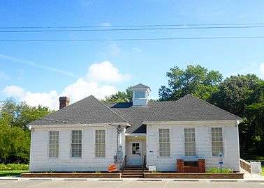 Front of Whitesboro School
 World War I memorial
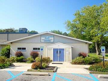 Martin Luther King Community Center
References
- 1 2 3 4 Gazetteer of New Jersey Places, United States Census Bureau. Accessed July 21, 2016.
- ↑ U.S. Geological Survey Geographic Names Information System: Whitesboro Census Designated Place, Geographic Names Information System. Accessed October 19, 2012.
- 1 2 3 4 5 6 DP-1 - Profile of General Population and Housing Characteristics: 2010 Demographic Profile Data for Whitesboro CDP, New Jersey, United States Census Bureau. Accessed October 19, 2012.
- ↑ Look Up a ZIP Code for Whitesboro, NJ, United States Postal Service. Accessed October 19, 2012.
- ↑ American FactFinder, United States Census Bureau. Accessed September 4, 2014.
- ↑ US Board on Geographic Names, United States Geological Survey. Accessed September 4, 2014.
- ↑ Locality Search, State of New Jersey. Accessed April 19, 2015.
- ↑ New Jersey: 2010 - Population and Housing Unit Counts - 2010 Census of Population and Housing (CPH-2-32), United States Census Bureau, August 2012, pg. III-3. Accessed October 19, 2012. "Cape May County—New CDPs: Belleplain, Burleigh (formed from part of deleted Whitesboro-Burleigh CDP and additional area), and Whitesboro (formed from part of deleted Whitesboro-Burleigh CDP); Deleted CDPs: Whitesboro-Burleigh (split to form all of Whitesboro and part of Burleigh CDPs)."
- ↑ US Gazetteer files: 2010, 2000, and 1990, United States Census Bureau. Accessed September 4, 2014.
- ↑ "Embrace Diversity With Stedman Graham: 'Diversity: Leaders Not Labels' Teaches Readers to Harness Their Skills and Achieve Success", ABC News, September 21, 2006. Accessed June 17, 2007. "Students were bused from Whitesboro to attend Middle Township schools, where I attended an integrated high school."
External links
| Wikimedia Commons has media related to Whitesboro, New Jersey. |
- The Cape May County Gazette, community newspaper
- The Beachcomber
Municipalities and communities of Cape May County, New Jersey, United States | ||
|---|---|---|
| Cities | 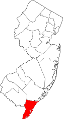 | |
| Boroughs | ||
| Townships | ||
| CDPs | ||
| Other unincorporated communities | ||